Overview
A couple of rounds of showers and thunderstorms affected the area on Saturday May 20th. Widespread rain and embedded thunderstorms moved from west to east across northern Indiana, southern Lower Michigan, and northwest Ohio during the day Saturday. Additional storms developed across northwest Indiana late Saturday afternoon and then moved across northern Indiana on Saturday evening. These thunderstorms in this second round developed to the north of a warm front and several of the cells exhibited storm scale rotation. One of the thunderstorms produced a weak tornado across the far western portions of White county in northern Indiana. The main threat transitioned to heavy rainfall and flooding later Saturday evening.
Flooding
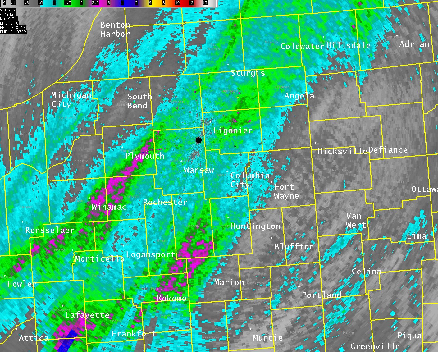
The combination of a warm front lifting northward, much above normal moisture for late May, and an upper level system approaching from the west resulted in some heavy rainfall across the area. The image below represents radar rainfall estimates for May 20th (see Rainfall tab for actual rainfall observations). A couple of swaths of heavy rainfall can be noted from the radar estimates. The first swath extends from northern White county into southwest Elkhart county, with a second area of heavy rainfall from southern Miami county across the western portions of Huntington county. Rainfall amounts in these heaviest axes were in the 1.5 to 4 inch range.
Radar Estimated Rainfall
 |
Radar:
 |
 |
|
KIWX 0.5 degree Storm Relative Motion
|
Rotational Tracks from KIWX radar. Indicates the history of storm scale rotation with the storm that produced the weak tornado in western White county. |
Storm Reports
PRELIMINARY LOCAL STORM REPORT...SUMMARY
NATIONAL WEATHER SERVICE NORTHERN INDIANA
1234 AM EDT SUN MAY 21 2017

..TIME...   ...EVENT...      ...CITY LOCATION...     ...LAT.LON...
..DATE...   ....MAG....      ..COUNTY LOCATION..ST.. ...SOURCE....
            ..REMARKS..

0735 PM     TORNADO          8 SSW WOLCOTT           40.65N 87.09W
05/20/2017                   WHITE              IN   TRAINED SPOTTER

            TRAINED SPOTTER REPORTS SLENDER/ROPE CONE
            TORNADO.

0914 PM     HEAVY RAIN       1 WNW INDIANA BEACH     40.80N 86.79W
05/20/2017  M2.01 INCH       WHITE              IN   MESONET


1004 PM     HEAVY RAIN       2 E WINAMAC             41.06N 86.57W
05/20/2017  E4.00 INCH       PULASKI            IN   PUBLIC

            RELAYED FROM BROADCAST MEDIA. ANOTHER PERSON
            HAD ENTIRE FRONT YARD UNDER WATER AND
            BASEMENT FLOODING.

1024 PM     HEAVY RAIN       1 ESE NAPPANEE          41.44N 85.97W
05/20/2017  M2.57 INCH       ELKHART            IN   MESONET

            SINCE MIDNIGHT.

1024 PM     HEAVY RAIN       3 SW BOURBON            41.27N 86.15W
05/20/2017  M3.24 INCH       MARSHALL           IN   MESONET

            SINCE MIDNIGHT.

1102 PM     FLOOD            3 E LINCOLNVILLE        40.76N 85.62W
05/20/2017                   HUNTINGTON         IN   TRAINED SPOTTER

            WATER ACROSS ROADWAY SOUTH OF CHAPEL RD AND
            SR 105.

1110 PM     FLOOD            4 NNW MOUNT ETNA        40.80N 85.58W
05/20/2017                   HUNTINGTON         IN   TRAINED SPOTTER

            WATER ACROSS ROADWAY.

1121 PM     HEAVY RAIN       1 ESE NAPPANEE          41.44N 85.97W
05/20/2017  M3.17 INCH       ELKHART            IN   MESONET

            SINCE MIDNIGHT.

1122 PM     HEAVY RAIN       GOSHEN                  41.58N 85.84W
05/20/2017  M2.47 INCH       ELKHART            IN   MESONET

            SINCE MIDNIGHT.

1124 PM     HEAVY RAIN       2 ESE SOMERSET          40.66N 85.79W
05/20/2017  M2.74 INCH       WABASH             IN   MESONET

            SINCE MIDNIGHT.

1124 PM     HEAVY RAIN       3 WSW AMBOY             40.59N 85.98W
05/20/2017  M2.63 INCH       MIAMI              IN   MESONET

            SINCE MIDNIGHT.

1126 PM     HEAVY RAIN       2 NW MARION             40.57N 85.69W
05/20/2017  M1.63 INCH       GRANT              IN   MESONET

            SINCE MIDNIGHT.

1127 PM     HEAVY RAIN       WINONA LAKE             41.22N 85.82W
05/20/2017  M1.94 INCH       KOSCIUSKO          IN   MESONET

            SINCE MIDNIGHT.

1129 PM     HEAVY RAIN       1 NNW LARWILL           41.19N 85.63W
05/20/2017  M1.81 INCH       WHITLEY            IN   MESONET

            SINCE MIDNIGHT.

1130 PM     HEAVY RAIN       2 SE CENTREVILLE        41.90N 85.49W
05/20/2017  M1.61 INCH       ST. JOSEPH         MI   MESONET

            SINCE MIDNIGHT.

1134 PM     HEAVY RAIN       1 SW GOSHEN             41.57N 85.85W
05/20/2017  M2.05 INCH       ELKHART            IN   COCORAHS

            SINCE MIDNIGHT.

1136 PM     FLOOD            4 S HUNTINGTON          40.83N 85.51W
05/20/2017                   HUNTINGTON         IN   TRAINED SPOTTER

            WATER ACROSS THE ROADWAY.
Rain Reports
Public Information Statement
National Weather Service Northern Indiana
141 AM EDT Sun May 21 2017

...Rainfall Reports Last 24 Hours...

Location                     Amount    Time/Date       Lat/Lon

...Indiana...

...Elkhart County...
1 ESE Nappanee               3.17 in   1121 PM 05/20   41.44N/85.97W
1 ESE Nappanee               2.57 in   1024 PM 05/20   41.44N/85.97W
Goshen                       2.47 in   1122 PM 05/20   41.58N/85.84W
1 SW Goshen                  2.05 in   1134 PM 05/20   41.57N/85.85W

...Huntington County...
1 ENE Bowerstown             1.79 in   0100 AM 05/21   40.90N/85.41W
3 SSW Huntington             1.76 in   0118 AM 05/21   40.83N/85.53W

...Kosciusko County...
Northern Indiana Wfo         2.13 in   1200 AM 05/21   41.36N/85.70W
Winona Lake                  1.94 in   1127 PM 05/20   41.22N/85.82W
2 SW Warsaw                  1.66 in   0112 AM 05/21   41.21N/85.87W
Tippecanoe Lake              1.65 in   0115 AM 05/21   41.33N/85.77W
2 N North Webster            1.63 in   0112 AM 05/21   41.36N/85.70W
2 WSW Syracuse               1.59 in   0117 AM 05/21   41.41N/85.79W

...Marshall County...
Plymouth                     3.67 in   0117 AM 05/21   41.34N/86.31W
3 SW Bourbon                 3.24 in   1024 PM 05/20   41.27N/86.15W
2 W Mentone                  1.57 in   0118 AM 05/21   41.18N/86.08W

...Miami County...
3 WSW Amboy                  2.63 in   1124 PM 05/20   40.59N/85.98W
3 W Amboy                    2.63 in   0120 AM 05/21   40.59N/85.98W

...Noble County...
3 NE Avilla                  1.70 in   0114 AM 05/21   41.40N/85.20W
1 E Big Lake                 1.57 in   0106 AM 05/21   41.28N/85.47W

...Pulaski County...
2 E Winamac                  4.00 in   1004 PM 05/20   41.06N/86.57W

...Steuben County...
1 SE Crooked Lake            1.76 in   0118 AM 05/21   41.66N/85.02W
2 W Silver Lake              1.69 in   1215 AM 05/21   41.63N/85.11W

...Wabash County...
2 ESE Somerset               3.26 in   0118 AM 05/21   40.66N/85.79W
Somerset                     2.93 in   0120 AM 05/21   40.66N/85.81W
2 ESE Somerset               2.74 in   1124 PM 05/20   40.66N/85.79W
2 ESE Lagro                  1.77 in   1215 AM 05/21   40.81N/85.68W

...White County...
Norway                       2.57 in   1145 PM 05/20   40.78N/86.76W
1 WNW Indiana Beach          2.01 in   0914 PM 05/20   40.80N/86.79W
1 WNW Indiana Beach          1.90 in   0115 AM 05/21   40.80N/86.79W

...Whitley County...
1 NNW Larwill                1.81 in   1129 PM 05/20   41.19N/85.63W
Tri-lakes                    1.60 in   0107 AM 05/21   41.22N/85.48W
2 NE Tri-Lakes               1.54 in   0113 AM 05/21   41.25N/85.45W

Observations are collected from a variety of sources with varying
equipment and exposures. We thank all volunteer weather observers
for their dedication. Not all data listed are considered official.
Environment
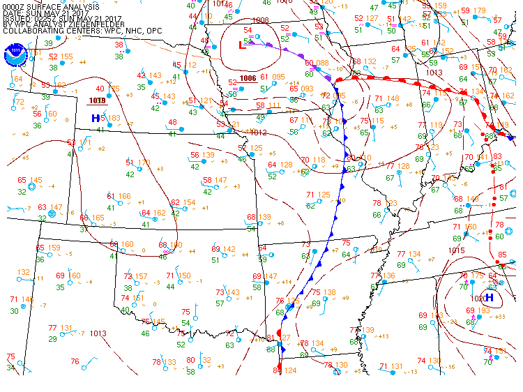
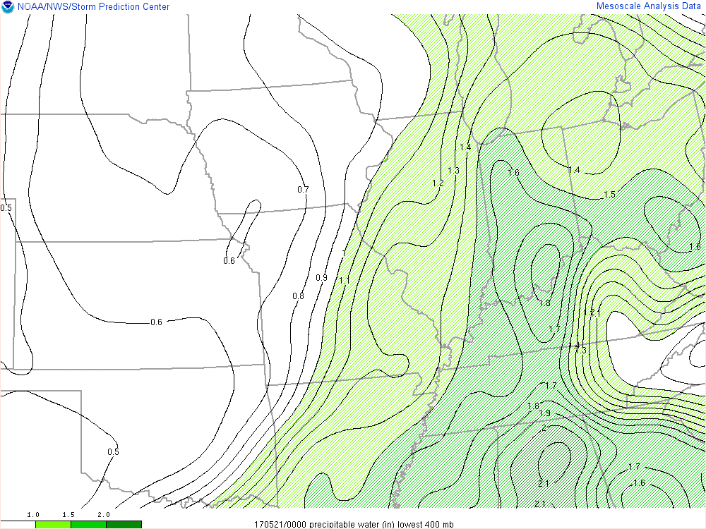
A very moist air mass moved into the area Saturday setting the stage for heavy rainfall Saturday evening. The strongest thunderstorms were located across southern portions of the forecast area where the greatest instability was located to the north of the warm front.
 |
 |
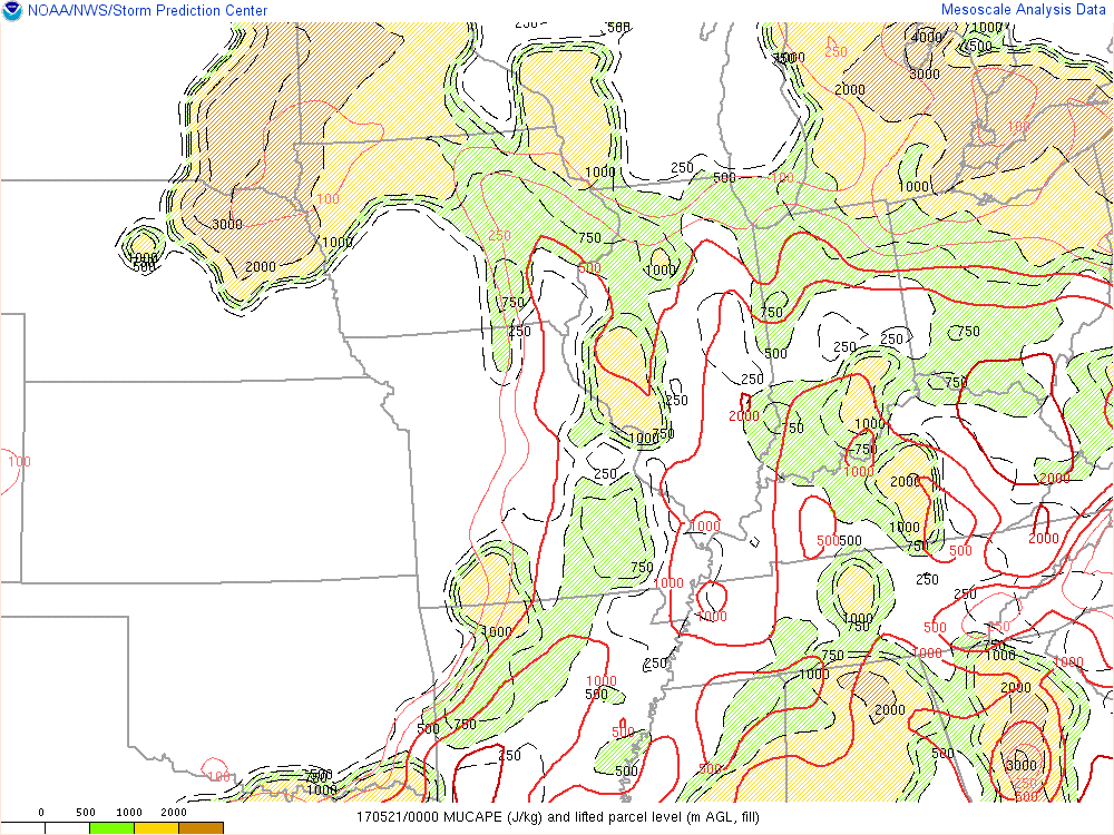 |
| 8pm May 20 Surface Analysis | 8pm May 20 Precipitable Water | 8pm May 20 Most Unstable CAPE |
 |
Media use of NWS Web News Stories is encouraged! Please acknowledge the NWS as the source of any news information accessed from this site. |
|

