|
PARAMETER |
WATCH |
WARNING |
ADVISORY |
|---|---|---|---|
|
BLIZZARD |
Potential for Sustained wind or frequent gusts > 35 mph and visibility ¼ mi < in S/BS for > 3 hrs in the next 12 to 48 hours
WINTER STORM WATCH |
Sustained wind /frequent gusts > 35 mph and visibility < ¼ mile in snow/blowing snow for > 3 hours
BLIZZARD WARNING |
NOT ISSUED |
|
BLOWING DUST |
NOT ISSUED |
NOT ISSUED |
Widespread visibility < ¼ mile |
|
FIRE |
Potential for ten hour fuels <= 8%, sustained winds >= 20 mph for 3 hours or more, RH <= 25% for 3 hours or more
|
ten hour fuels <= 8%, sustained winds >= 20 mph for 3 hours or more, RH <= 25% for 3 hours or more RED FLAG WARNING |
NOT ISSUED |
|
DENSE FOG |
NOT ISSUED |
NOT ISSUED |
Widespread visibility < ¼ mile |
|
FREEZE |
Potential for Temperatures < 32°F or < 28°F between May 1 and November 1.
FREEZE WATCH |
Temperatures < 32°F or < 28°F between May 1 and November 1.
FREEZE WARNING |
NOT ISSUED |
|
FROST |
Address potential in the HWO and other notification methods. |
NOT ISSUED |
Formation of frost between May 1 and November 1. (Temperatures less than or equal to 36).
FROST ADVISORY |
|
FREEZING RAIN |
Potential for freezing rain with significant /damaging ice accumulations (usually ≥ ¼")
WINTER STORM WATCH |
Ice accumulation ≥ ¼" on all surfaces
ICE STORM WARNING |
Light ice accrual generally < ¼" of an inch on all surfaces
WINTER WEATHER ADVISORY |
|
FREEZING FOG |
Address potential in HWO and other notification methods. |
NOT ISSUED |
Very light ice accumulation from freezing fog |
|
EXTREME HEAT |
|
HI > 105° F and the minimum heat index of at least 75° F for a 48 hour period. Consider a HI warning if Heat advisory conditions are met for 4 consecutive days |
HI around 100° F and/or |
|
SLEET
|
Sleet ≥ ½" accumulation WINTER STORM WATCH |
Sleet Accumulation > ½" WINTER STORM WARNING |
Sleet Accumulation < ½" WINTER WEATHER ADVISORY |
|
SNOW
|
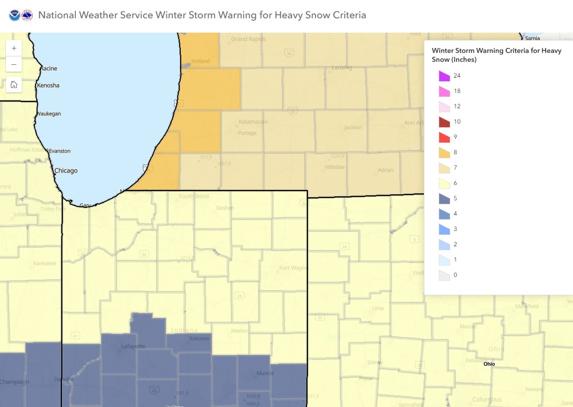
See Figure 1 below. Michigan: Berrien County ≥ 8". Branch, Cass, Hillsdale, St. Joseph: ≥ 7" Indiana: ≥ 6"
WINTER STORM WATCH |
See Figure 1 below. Michigan: Berrien County ≥ 8". Branch, Cass, Hillsdale, St. Joseph: ≥ 7" Indiana: ≥ 6" WINTER STORM WARNING |
3 to 5 inches
WINTER WEATHER ADVISORY |
|
WIND |
Sustained non-convective wind > 40 mph
|
Sustained non-convective wind > 40 mph for > 1 hour and/or gusts > 58 mph HIGH WIND WARNING |
Sustained non-convective wind between 30 and 39 mph for > 1 hour and/or gusts between 45 - 57 mph WIND ADVISORY |
|
EXTREME COLD |
Potential for Wind Chill ≤ -25° F EXTREME COLD WATCH |
Wind Chill < -25° F EXTREME COLD WARNING |
Wind Chill -15° F to -24° F COLD WEATHER ADVISORY |
|
WINTER STORM
|
Combination of Snow, Sleet and Freezing Rain Meeting Warning Criteria, and/or Blowing and Drifting Snow Approaching Blizzard Conditions; Mixed Precipitation (lesser amounts if mixed precipitation) WINTER STORM WATCH |
Combination of any winter warning hazards, including significant blowing and drifting snow below blizzard conditions (lesser amounts may be warranted especially if significant mixed precipitation in an early or late season event) WINTER STORM WARNING |
|
|
WINTER WEATHER |
|
|
Combination of any winter advisory hazards WINTER WEATHER ADVISORY |
Figure 1: Winter Storm Warning for Heavy Snow Criteria.