Overview
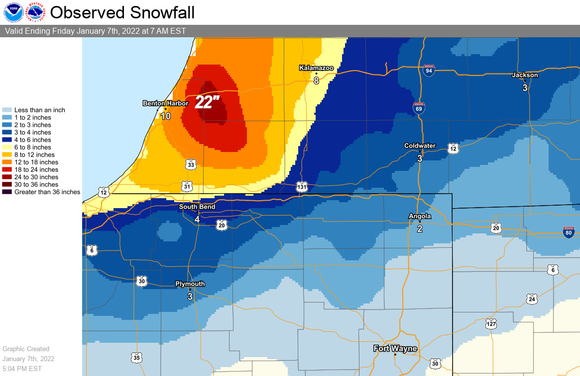
Arctic airmass brought cold temperatures and lake effect snow to the area. SW Lower MI was most impacted by the lake effect snow as a single band of 1-2" per hour snowfall rates dropped into Berrien/Cass counties around 8 pm on January 6th and lingered overnight. After a lull in lake effect on Friday morning, another dominant band formed during afternoon and affected South Haven to north of Three Rivers during the afternoon. 8 to 14 inches fell overnight across northern Berrien County with 48 hour totals of 19 to 24 inches across far northern/northeast Berrien County. Wind chills Thursday night into Friday morning ranged from 5 to 15 below zero.A combination of several lake effect snow bands spread a swath of heavy snow across a narrow corridor of counties in southwest Lower Michigan. As is typical of this type of snow, the accumulation came fast and the gradient of snow was tight.
Photos:
 |
 |
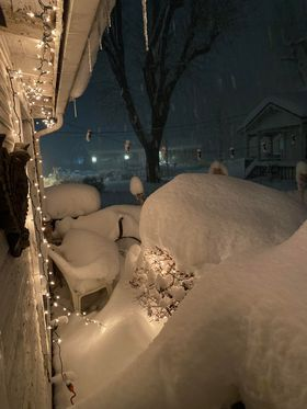 |
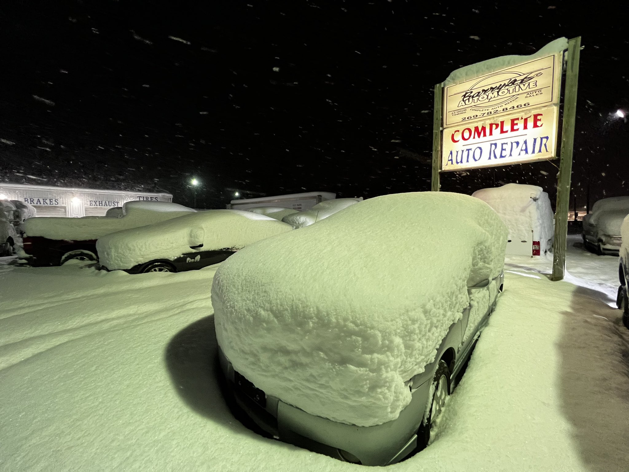
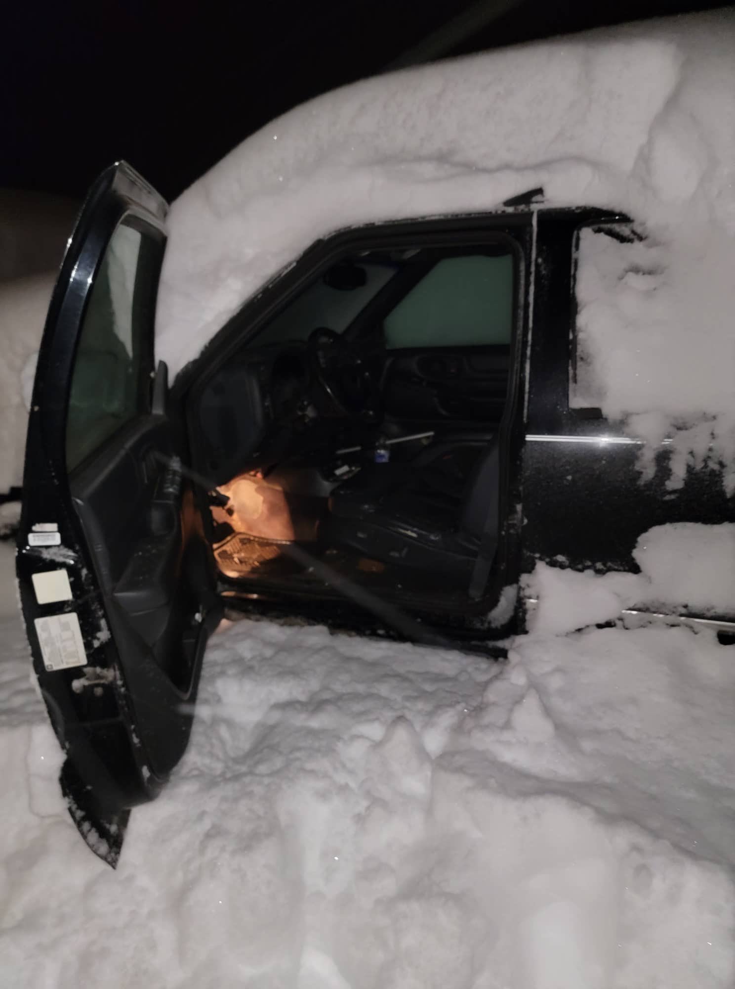
| Heavy Lake Effect Snowfall in Dowagiac, MI. Photo courtesy of Chicago & Midwest Storm Chasers @ChicagoMWeather | Snow covered this vehicle in Dowagiac, MI. Photo courtesy of Maci Tetrick and Michael E. | Lake Effect Snow makes a winter wonderland on these shrubs outside of a home on the Cass County / Van Buren County Line. Photo provided by Matt Rudkin @MattRudkinWx |
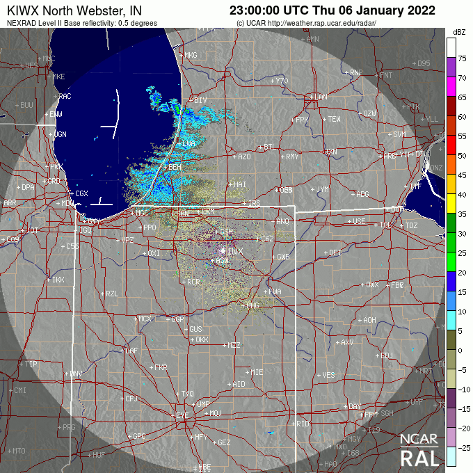
Radar:
Radar evolution of lake effect snow bands:
Initially light lake effect snow showers were ongoing from the previous event with westerly flow of 15 to 25 knots, a few gusts to around 30 knots at times in the evening. Better accumulation began when a W-E oriented band developed from Lake MI around 6 PM EST Thursday from roughly Stevensville, MI (Berrien Co) to Dowagiac, MI (Cass Co). This dropped southward through about 8:30 PM EST before weakening.
Meanwhile, the single band connected up to Lake Superior and huddled somewhat near the Lake MI Shoreline (W-E initially) dropped steadily southward through the late afternoon/evening hours with 1-2" snow rates-causing accidents, visibilities less than 1/2 mile (blowing/drifting/falling snow), and road closures (US 131, and others). This band entered Berrien County around 8 PM EST Thursday evening and spread into Cass county (Michigan).
By 2 AM EST Friday, the band took on a more NNW-SSE orientation, extending from Benton Harbor (KBEH) down to the Edwardsburg, MI area. There were numerous videos on Twitter and reports of the accidents from a group of chasers following the band.
Another dominant band formed from South Haven to north of Three Rivers in the mid-afternoon Friday.
 |
|
| 24 hour loop of 0.5 degree Reflectivity from KIWX radar of lake effect banding (6 pm January 6 to 6 pm January 7) |
Storm Reports
.
Public Information Statement
National Weather Service Northern Indiana
448 PM EST Fri Jan 7 2022

...SNOWFALL REPORTS OVER PAST 48 HOURS...

Location                     Amount    Time/Date       Lat/Lon

...Indiana...

...La Porte County...
0.8 W La Porte               1.0 in    1258 AM 01/07   41.61N/86.73W

...St. Joseph County...
2 S Indian Village           3.2 in    0700 AM 01/07   41.69N/86.23W
Granger 1.8 ENE              3.0 in    0700 AM 01/07   41.75N/86.11W
1 N New Carlisle             3.0 in    0100 PM 01/07   41.71N/86.51W
South Bend 3.3 SE            2.0 in    0800 AM 01/07   41.64N/86.23W
South Bend 4.6 SE            1.2 in    0700 AM 01/07   41.62N/86.22W
Mishawaka 3.9 ENE            1.1 in    0710 AM 01/07   41.68N/86.10W

...Michigan...

...Berrien County...
Watervliet                   22.0 in   0100 PM 01/07   42.19N/86.26W
Eau Claire                   19.0 in   1245 AM 01/07   41.99N/86.30W
3 WSW Sandy Beach            12.0 in   0300 AM 01/07   42.04N/86.23W
3 S Watervliet               10.0 in   0100 PM 01/07   42.15N/86.25W
Buchanan 1.3 WNW             8.5 in    0600 AM 01/07   41.84N/86.39W
Niles 2.7 W                  8.5 in    0800 AM 01/07   41.84N/86.30W
Shoreham 2.0 SE              8.1 in    0800 AM 01/07   42.03N/86.49W
3 ESE Berrien Springs        6.5 in    0617 PM 01/06   41.93N/86.30W
St. Joseph 1.5 SSE           6.0 in    0700 AM 01/07   42.08N/86.48W
Buchanan 1.4 ESE             5.8 in    0700 AM 01/07   41.82N/86.34W
Bertrand                     5.0 in    0800 AM 01/07   41.77N/86.26W
1 WNW Sodus                  5.0 in    0900 AM 01/07   42.05N/86.39W
Shoreham 2.0 SE              4.8 in    0800 AM 01/07   42.03N/86.49W
Saint Joseph                 4.7 in    0900 AM 01/07   42.10N/86.49W
Bertrand                     4.5 in    0800 AM 01/07   41.77N/86.26W
Stevensville 1.7 SSE         4.4 in    0845 AM 01/07   41.99N/86.51W
3 ESE Berrien Springs        4.3 in    0751 AM 01/07   41.93N/86.30W
Buchanan 1.3 WNW             4.0 in    0600 AM 01/07   41.84N/86.39W
St. Joseph 2.8 SSE           4.0 in    0700 AM 01/07   42.06N/86.47W
Buchanan 1.4 ESE             3.5 in    0700 AM 01/07   41.82N/86.34W
Stevensville 1.7 SSE         3.5 in    0845 AM 01/07   41.99N/86.51W
St. Joseph 1.5 SSE           3.0 in    0700 AM 01/07   42.08N/86.48W

...Cass County...
3 E Magician Lake            15.0 in   1120 PM 01/06   42.06N/86.11W
1 SSE Indian Lake            15.0 in   0344 AM 01/07   41.98N/86.20W

...St. Joseph County...
Three Rivers 2.4 NE          1.5 in    0700 AM 01/07   41.97N/85.60W
0.7 S Three Rivers           1.4 in    0700 AM 01/07   41.93N/85.63W

Observations are collected from a variety of sources with varying
equipment and exposures. We thank all volunteer weather observers
for their dedication. Not all data listed are considered official.
 |
Media use of NWS Web News Stories is encouraged! Please acknowledge the NWS as the source of any news information accessed from this site. |
|

