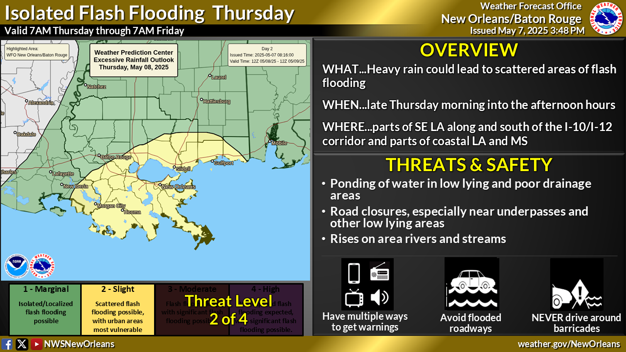
National Weather Service United States Department of Commerce
Click a location below for detailed forecast.

Last Map Update: Mon, Apr 6, 2026 at 1:08:28 pm CDT

Mild and breezy conditions are expected through Thursday with highs in the 70s each day. Tuesday will be dry, but scattered afternoon showers and storms will return for Wednesday and Thursday.
Elevated Tides / Coastal Flooding mid to late week during high tide cycles. Strong easterly winds are expected to develop by early to mid week, with sustained winds of 15–25 kt and gusts of 30–35 kt continuing through at least Thursday. These persistent onshore winds, combined with the ongoing spring tide cycle, will likely lead to coastal flooding from Tuesday into the latter part of the week.


CoCoRaHS
CoCoRaHS - Click for more information
Submit
Storm Report

Submit a Storm Report

River Stages
Latest River Stages


Quick Access to Text Products


 Current Weather Observations...
Location Time
(CDT)
Weather Vsby.
(SM)
Temp.
(ºF)
Dewpt.
(ºF)
Hum.
(%)
Wind
(mph)
Wind Chill / Heat Index
(ºF)
Pres.
(in)
Baton Rouge LA12:53Clear10654039NE 10G21-30.21
Biloxi MS10:55Mostly Clear10594354NNE 14G22-30.16
Gulfport MS12:53Clear10604251NNE 10G21-30.16
Hammond LA12:55Clear10624043NNE 12G16-30.20
Houma LA12:47Clear7604455E 18-30.19
McComb MS09:53Partly Cloudy10756775SSE 12-30.14
New Orleans LA12:53Mostly Cloudy10624145N 13G23-30.18
Slidell La12:53Clear10614147N 13G20-30.17