National Weather Service United States Department of Commerce

Multiple Days of Severe Weather from Thunderstorms and Wildfires

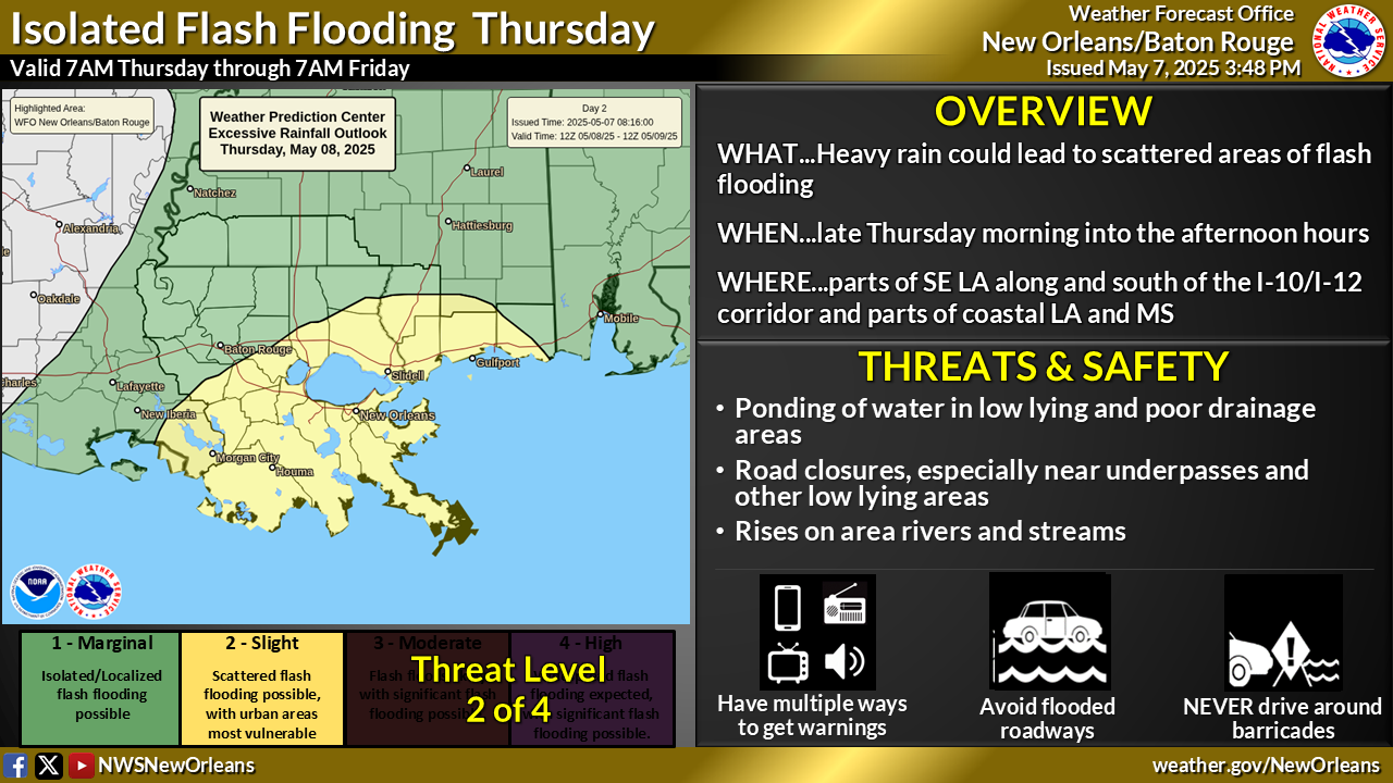
Active spring pattern across the center of the nation with several rounds of severe thunderstorms in the forecast through the weekend. The regions under the greatest threats are the southern Plains into the Mississippi Valley. Meanwhile, dry and breezy conditions with dry fuels are aiding in wildfires across the western High Plains and the Southeast. Wind and some snow for northern Rockies. Read More >

Click a location below for detailed forecast.

Last Map Update: Fri, Apr 24, 2026 at 3:40:13 pm CDT

This Weekend: Monitoring 3 Possible Rounds of Storms. Fri night/Sat morning: Storms approach from the northwest. Medium confidence, mainly in regards to how far/strong the complex can hold together. Main impacts if this occurs: damaging winds, large hail, damaging winds. Round 2: Saturday afternoon/evening, some scattered showers or storms pop up. Low to medium confidence if these storms can develop, if so where and how strong. Main impacts if these occur: gusty winds, large hail, dangerous lightning. Sunday morning and afternoon, another complex possible from the northwest. Forecast confidence is low if this complex can form and how strong it will be. Main impacts if this occurs, damaging winds large hail and dangerous lightning. These storms are expected to drift south and east thru Friday evening/night into northern Louisiana and central Mississippi. What We Don’t Know: If these storms can organize into a complex and continue/persist south and east thru the overnight hours. If so, how strong or severe these storms might be. Check back!
There is a SLIGHT Risk of Severe Weather (level 2 of 5) for late Friday night into Saturday morning across southeast Louisiana and southern Mississippi. Individual hazard threats are as follows. Wind threat: level 2 of 5. Slight risk of wind damage from winds 60+ mph. Hail threat: low, but possible isolated hail quarter size or larger. Tornado threat: level 1 of 5. A few mostly weak tornadoes. Flood threat: minimal. Ponding in poor drainage areas. Monitor the forecast for changes. Plan ahead for where you will take shelter if needed.
Rain chances gradually increase into Saturday, with scattered showers and storms most likely in the morning. Isolated showers and storms remain possible Friday and Sunday, while early next week trends warmer and mostly dry. By Tuesday, highs climb into the lower 90s with near-record warmth possible and only limited rain chances.


CoCoRaHS
CoCoRaHS - Click for more information
Submit
Storm Report

Submit a Storm Report

River Stages
Latest River Stages


Quick Access to Text Products


 Current Weather Observations...
Location Time
(CDT)
Weather Vsby.
(SM)
Temp.
(ºF)
Dewpt.
(ºF)
Hum.
(%)
Wind
(mph)
Wind Chill / Heat Index
(ºF)
Pres.
(in)
Baton Rouge LA14:53Mostly Cloudy10836656S 9-29.81
Biloxi MS14:55Partly Cloudy10806866SSE 12-29.84
Gulfport MS14:53Partly Cloudy10796766SSE 13G24-29.86
Hammond LA15:15Lightning Observed10837066S 12-29.82
Houma LA14:47Partly Cloudy7806969SSE 15-29.86
McComb MS14:53Mostly Cloudy10846654-29.81
New Orleans LA14:53Cumulonimbus Clouds, Towering Cumulus Clouds Observed10816967S 15G24-29.84
Slidell La14:53Lightning Observed10806662S 13-29.85