National Weather Service United States Department of Commerce
Click a location below for detailed forecast.

Last Map Update: Wed, Apr 1, 2026 at 3:18:16 pm CDT

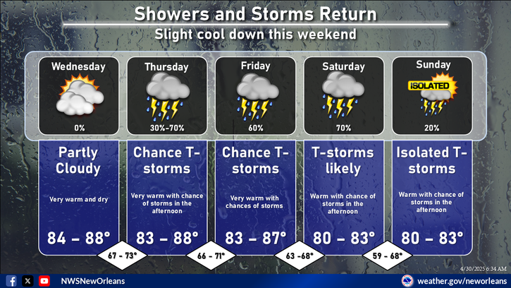
Scattered to numerous showers and storms are expected this afternoon and evening. While not everyone will see rain, coverage will be fairly widespread across the region.
Daily rain chances continue through Friday with the greatest coverage midweek. Most areas will see light totals, though locally higher amounts are possible. Temperatures remain above normal.
Looking at long-term forecasts, there's a slight chance that the local area will see above-normal temperatures.
Looking at long-term forecasts suggest rainfall is leaning toward near normal for this time of year.


CoCoRaHS
CoCoRaHS - Click for more information
Submit
Storm Report

Submit a Storm Report

River Stages
Latest River Stages


Quick Access to Text Products


 Current Weather Observations...
Location Time
(CDT)
Weather Vsby.
(SM)
Temp.
(ºF)
Dewpt.
(ºF)
Hum.
(%)
Wind
(mph)
Wind Chill / Heat Index
(ºF)
Pres.
(in)
Baton Rouge LA14:53Thunder In The Vicinity \ Lightning Observed10876243SSW 13G18-30.03
Biloxi MS14:55Lightning Observed10776873SSE 15G22-30.09
Gulfport MS14:55Overcast10766979ESE 16-30.11
Hammond LA14:55Lightning Observed10816966SE 10-30.07
Houma LA14:47Partly Cloudy7806865S 14-30.09
McComb MS09:53Partly Cloudy10756775SSE 12-30.14
New Orleans LA14:53Cumulonimbus Clouds Observed10836656SSE 14-30.07
Slidell La14:53Lightning Observed10816762S 20G29-30.08