...2012 YEARLY CLIMATE SUMMARY...
Synopsis:
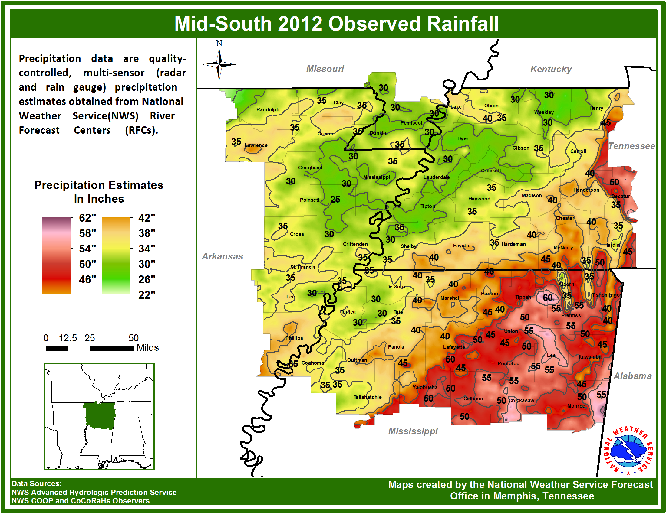
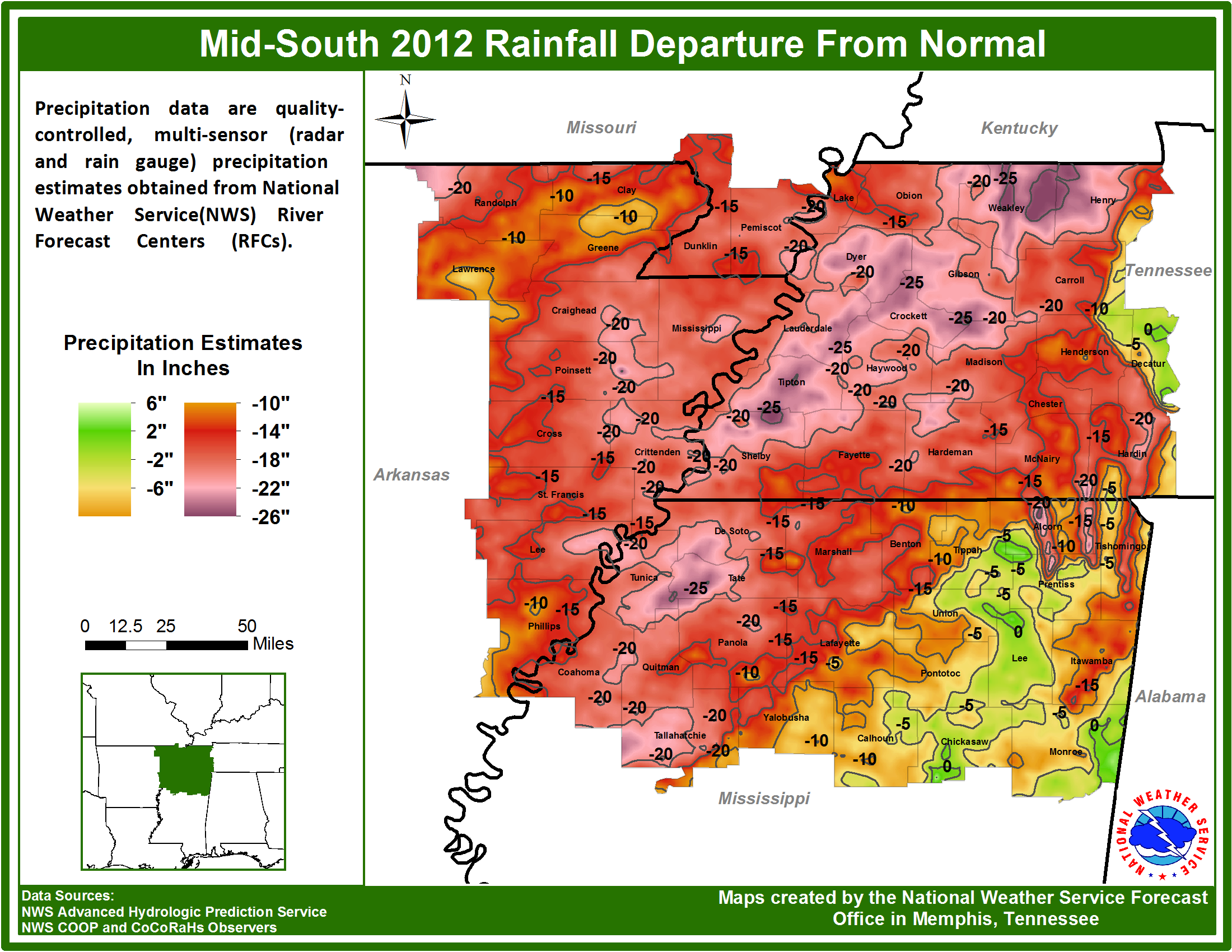
2012 was a record setter in many ways for the Mid-South Region. From relentless heat to extreme drought, the weather in 2012 had various adverse impacts on property and commerce across the area. As for the official climate sites, 2012 ranked in at least the top 4 for all sites. 2012 was the all-time warmest year on record at Memphis, number two all-time at Jackson and Jonesboro, while Tupelo came in at number four all-time. The intense heat was no doubt aided by the extreme drought conditions that were seen across most of the Mid-South region. Areas along and north of the I-40 corridor saw the worst drought conditions of all, where most of the region remained in the D3-D4 drought range. Aside from the agricultural impacts of the drought, the Mississippi River saw near record low levels during the summer/early fall season. This caused major impacts to commerce on the river as some vessels were docked, or loads were lightened for fears of running aground in shallow waters. Likewise, some river ports along the Mississippi River were closed temporarily for the same reasons. The lowest water stage in Memphis for the year occurred on September 19th with a value of -9.86 feet, which was second all-time. The lowest ever recorded water level in Memphis occurred on July 10th, 1988 when the stage came in at -10.70 feet. Below is a Drought Monitor graphic from early August, which was the peak of the drought in 2012. Also included are two estimated yearly rainfall graphics for the Mid-South:

The chart below contains all the notable 2012 climate data for all four official climate sites in the Mid-South:
|
|
Memphis |
Jackson |
Jonesboro |
Tupelo |
|
Average Temp |
65.8 |
62.2 |
63.7 |
64.5 |
|
Normal Avg. Temp |
63.1 |
59.8 |
60.0 |
62.5 |
|
Departure from Normal |
2.7 |
2.4 |
3.7 |
2.0 |
|
Warmest Day(s) |
103(6/29,7/5) |
104(7/6) |
105(7/19) |
106(6/29) |
|
Coldest Day(s) |
21(12/30) |
17(1/3) |
18(12/27) |
19(2/12) |
|
Total Precipitation |
36.90 |
42.01 |
33.57 |
49.77 |
|
Normal Precipitation |
53.68 |
53.27 |
48.10 |
55.01 |
|
Departure from Normal |
-16.78 |
-11.26 |
-14.53 |
-5.24 |
|
Wettest Day(s) |
1.78(5/31) |
2.32(7/18) |
3.17(9/7) |
2.95(9/17) |
|
Snowiest Day(s) |
0.9(12/26) |
0.5(12/26) |
4.5(12/25) |
T(2/13,12/26) |
Records Set and Notable Statistics:
Memphis:
#1 Warmest Year – Average Temp of 65.9 Degrees
#1 Warmest March - Average Temp of 64.8 Degrees
#2 Driest April – Total Precipitation of 1.04 Inches
#4 Warmest May - Average Temp of 76.3 Degrees
#6 Warmest July - Average Temp of 85.3 Degrees
#8 Warmest December - Average Temp of 49.8 Degrees
#8 Wettest September – Total Precipitation of 7.01 Inches
#8 Driest Year – Total Precipitation of 36.90 Inches
Jackson:
#1 Warmest March - Average Temp of 61.7 Degrees
#1 Driest April – Total Precipitation of 1.15 Inches
#2 Warmest Year - Average Temp of 62.2 Degrees
#5 Warmest December - Average Temp of 47.0 Degrees
#6 Warmest January - Average Temp of 44.8 Degrees
#7 Warmest May - Average Temp of 72.5 Degrees
#7 Coolest October - Average Temp of 57.9 Degrees
#8 Driest Year – Total Precipitation of 42.01 Inches
#8 Wettest September – Total Precipitation of 5.95 Inches
#9 Driest May – Total Precipitation of 2.05 Inches
#9 Driest November – Total Precipitation of 2.16 Inches
#10 Wettest July – Total Precipitation of 7.03 Inches
Jonesboro:
#1 Warmest March - Average Temp of 62.8 Degrees
#2 Warmest Year - Average Temp of 63.7 Degrees
#2 Warmest July - Average Temp of 85.7 Degrees
#3 Driest April – Total Precipitation of 1.22 Inches
#7 Warmest Month of All Time – July Average Temp of 85.7 Degrees
#7 Driest Year – Total Precipitation of 33.57 Inches
Tupelo:
#1 Warmest March – Average Temp of 63.8 Degrees
#4 Warmest Year - Average Temp of 64.6 Degrees
#4 All Time High Temperature – 106 Degrees 6/29/2012
#4 Driest November – Total Precipitation of 1.16 Inches
#6 Warmest May - Average Temp of 74.1 Degrees
#7 Wettest September – Total Precipitation of 7.71 Inches
#8 Warmest January - Average Temp of 48.2 Degrees
#8 Warmest December - Average Temp of 49.7 Degrees
#8 Driest April – Total Precipitation of 1.75 Inches
Significant Weather Events of 2012:
Drought: As mentioned above, 2012 was one of the worst droughts in fifty years for the central United States. The Agricultural industry felt perhaps the worst impacts from the drought as crop yields suffered. Elsewhere, major impacts to commerce were felt along some of the country’s most vital waterways.
Heat: One thing lead to another as upper level atmospheric flow patterns produced strong high pressure ridging over the central United States which in turn brought on the intense drought. This persistent ridging also kept skies clear allowing for abundant sunshine which helped to produce record heating. Although portions of the Mid-South saw many days were the temperatures exceeded the century mark, there were zero heat related fatalities that were reported to the National Weather Service.
Severe Weather: In comparison, 2012 was a rather calm year for severe weather across the Mid-South region. Unlike years past, there were no major widespread severe weather outbreaks to note. Likewise, there were zero severe weather related fatalities reported to the National Weather Service. There were however some localized events to note such as a few high wind events and a total of nine confirmed tornadoes across the region. Below is a chart describing those nine tornado events:
|
Date |
Time(LST) |
F-Scale |
Comments |
|
1/22/2012 |
2103 |
1 |
A tornado touched down in Monroe County Mississippi. A large shed was flipped over the top of a Quonset-shaped farm shop. Large holes were ripped into the sides of the shop. An irrigation pivot was overturned, tin was torn off tractor sheds and other types of sheds, and power poles/trees were blown down. The tornado exited Monroe County south-southeast of Palmer and entered Phillips County southwest of Postelle and continued to move northeast for a couple of miles before lifting. |
|
1/22/2012 |
2300 |
0 |
The tornado touched down just west of Marks Mississippi and moved northeast. About 7 homes were damaged. The damage included blown off shingles, minor roofing material, a garage door blown out and numerous windows broken. |
|
1/22/2012 |
2355 |
1 |
The tornado started about 5 miles south of Lexington Tennessee and moved northeast. Numerous trees were uprooted or snapped along the path. A portion of a roof was blown off a house. A shed in the backyard was also destroyed. The tornado touched down primarily on ridge tops before eventually lifting just northeast of Butterscotch Road. |
|
2/1/2012 |
2014 |
0 |
A tornado briefly touched down along Sipsey-Detroit Road near Sipsey Fork Mississippi, just west of the Mississippi-Alabama Border. The tornado moved northeast for approximately 200 yards. A single family home sustained minor damage which included the collapse of a carport. An awning of a mobile home was blown off. The mobile home also sustained damage from a shed that was lifted up by the tornado and thrown into the mobile home. The shed was destroyed as well as a nearby chicken coop. Several cedar trees were blown over or snapped. |
|
4/5/2012 |
1049 |
0 |
A weak tornado briefly touched down near the intersection of Highway K and Highway P. This is near the Netherlands Missouri area. No damage was reported. |
|
4/5/2012 |
1051 |
0 |
A weak tornado touched down just north of the Concord overpass near Interstate 55 at mile marker 24 in Missouri. No damage was reported. |
|
4/26/2012 |
1744 |
2 |
A tornado touched down along Highway 225 and Silerton Road near Montezuma Tennessee and moved southeast for roughly 2 miles. Six homes were damaged with two sustaining significant damage. A roof of a church sustained minor damage. A few farm sheds were damaged as well. A camper and boat was destroyed. Trees were snapped in the area and a few vehicles sustained shattered windows. A cotton module compress was also destroyed. The tornado lifted along Cecil Thomas Road. |
|
9/1/2012 |
1519 |
2 |
A tornado briefly touched down southwest of the Corning Arkansas Municipal Airport and traveled northeast across the northern portion of the airport. Two hangars were extensively damaged with a few others receiving minor damage. Many of the aircraft that were housed inside the hangar were heavily damaged as well. Two homes near the airport had windows blown out and a shed had the roof blown off. The tornado continued northeast crossing Highway 67. Power poles along the highway were knocked down. A clear path was seen in the bean field north of Highway 67. The tornado lifted near County Road 135. Large amounts of debris were found nearly 1.5 miles away from the airfield with one 930 pound piece of equipment found nearly a quarter of mile away from the building which it was being stored. |
|
9/1/2012 |
1522 |
0 |
A tornado briefly touched down in a farm field near the intersection of County Road 147 and Highway 67, northeast of Corning Arkansas. |
|
9/1/2012 |
1703 |
0 |
A tornado briefly touched down near the intersection of Highway N and US Highway 412 near Bucoda Missouri. A farm shed was damaged as well as the equipment inside. |
Winter Weather: 2012 got off to a slow start with regards to winter weather but finished strong by bringing a late white Christmas to the Mid-South Region. During the month of December, a strong upper level system moved through Christmas evening and into the following morning. Some areas in northeast Arkansas received upwards of 12-14 inches of snowfall. As for the official climate sites, Memphis International Airport reported 0.9 inches, Jackson McKellar Airport reported 0.5 inches, Tupelo Regional Airport reported a trace, and Jonesboro Regional Airport received the highest amount with 6.5 inches of snowfall.
CDG

