Memphis, TN
Weather Forecast Office
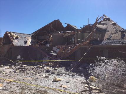
...NWS Surveys Northeast Mississippi Tornado Damage...
NWS survey rated this tornado an EF2 with maximum winds near 115 MPH. Most of the damage was EF0/EF1 with maximum damage near Burnsville Mississippi. No injuries reported, with a number of homes damaged significantly. The tornado began in southeastern Alcorn County; just north of Jacinto Community tracking northeast at approximately 8 miles just northeast of Burnsville.
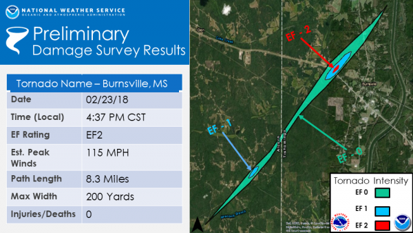
000
NOUS44 KMEG 252205
PNSMEG
MSZ002>006-009-013>017-TNZ053-089>092-261015-

PUBLIC INFORMATION STATEMENT
NATIONAL WEATHER SERVICE MEMPHIS TN
405 PM CST MON FEB 25 2019

...NWS DAMAGE SURVEY FOR 02/23/19 TORNADO EVENT NEAR BURNSVILLE
MISSISSIPPI...

.TORNADO NEAR BURNSVILLE, MISSISSIPPI...

RATING: EF2
ESTIMATED PEAK WIND: 115 MPH
PATH LENGTH /STATUTE/: 8.3 MILES
PATH WIDTH /MAXIMUM/: 200 YARDS
FATALITIES: 0
INJURIES: 0

START DATE:FEB/23/2019
START TIME: 0437 PM CST
START LOCATION: 7 SE BURNSVILLE, MS
START LAT/LON: 34.7899/-88.4084

END DATE: FEB/23/2019
END TIME: 0447 PM CST
END LOCATION: 1 NNE BURNSVILLE, MS
END LAT/LON: 34.8740/-88.3054

SURVEY SUMMARY:
MOST OF THE DAMAGE WAS EF0/EF1 WITH MAXIMUM NEAR BURNSVILLE. A
NUMBER OF HOMES WERE DAMAGED WITH MOST OF THE PATH IN RURAL
AREAS.

NOTE: INFORMATION IN THIS STATEMENT IS PRELIMINARY AND SUBJECT TO
CHANGE PENDING FINAL REVIEW OF THE EVENT AND PUBLICATION IN NWS
STORM DATA.

$$
CURRENT HAZARDS
Briefing Page
Outlooks
Submit a Storm Report
Submit a Storm Photo
View Storm Report
Spot Forecast Request
Hazard Outlook
FORECASTS
Local
Graphical
Probabilistic
Precipitation
Aviation
Fire
Severe Weather
Winter Weather
Tropical Weather
Air Quality
US Dept of Commerce
National Oceanic and Atmospheric Administration
National Weather Service
Memphis, TN
7777 Walnut Grove Road, OM1
Memphis, TN 38120
(901) 544-0399
Comments? Questions? Please Contact Us.

