Summary: Widespread damage was observed along a line from Houston, Mississippi to Camden, Tennessee on Saturday as the remnants of Tropical Storm Olga lifted through the Mid-South. Multiple structures were damaged, as well as countless trees and powerlines were downed. At least one fatality and one critical injury have been attributed to the remnants of Olga.
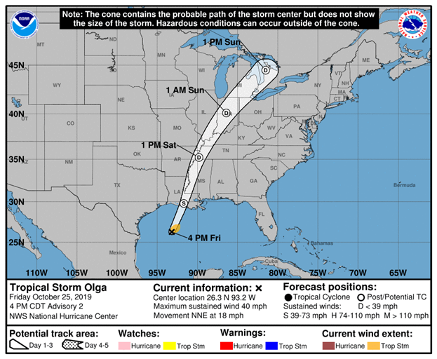
Setup: Tropical Storm Olga formed in the Gulf of America Friday afternoon near the Louisiana coast. Olga then transitioned to a Post-Tropical Storm and merged with a cold front as it quickly lifted northeast through the Lower Mississippi River Valley on Saturday.
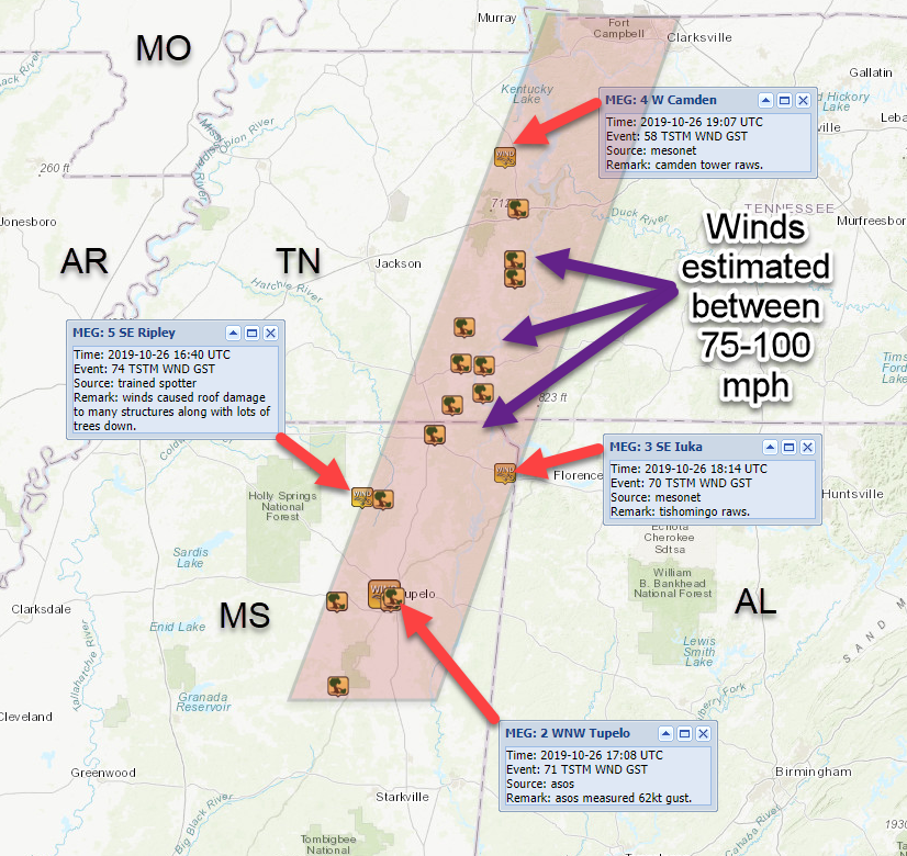
As Olga’s remnants moved into the Mid-South, sustained winds of 30-40 mph were reported at several sites for up to an hour as the storm passed over. The first instance of damage occurred near Houston, Mississippi, where county-wide tree damage was observed. Widespread damage continued along a north-northeast track for nearly 150 miles as it moved through Mississippi and Tennessee. Numerous trees, powerlines, and structures were damaged along the path, before Olga’s remnants moved east of the Tennessee River.
Some of the most impressive winds were recorded at Tupelo Municipal Airport. Multiple wind gusts of 50-70 mph occurred for nearly 45 minutes as Olga moved through. The circulation maintained its intensity as it tracked north into Corinth, MS and eventually into Adamsville, TN, where some of the worst damage was observed. Winds were estimated to be in the 75-100 mph range. Damage continued through west Tennessee along the Tennessee River and eventually crossed over Interstate-40. Several semis were flipped along the interstate as winds remained very strong. Damage continued into Camden, Tennessee before crossing the Tennessee River.
Data:
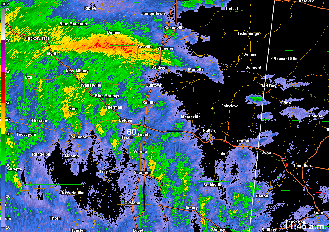
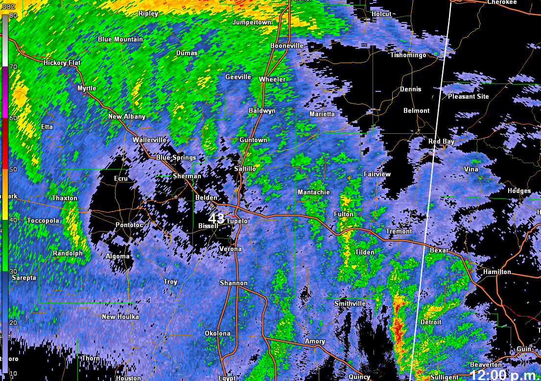
Columbus radar loop showing the storm from 11:05 a.m. till 1:45 p.m., October 26, 2019.

Remnants of Olga Preliminary Damage Track - Saturday, October 26th, 2019 (Blue boxes are measured wind gusts)
Olga Forecast Track (National Hurricane Center) Friday, October 25th, 2019
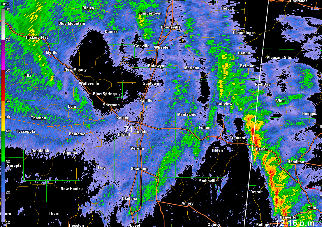
Radar images from Columbus Radar (11:40 am, 12:00 pm, 12:16 pm CDT) Observed wind gusts at Tupelo airport (shown in white)
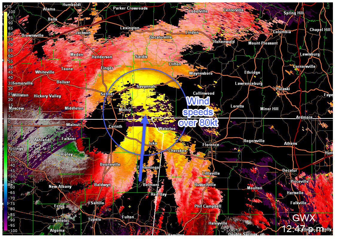
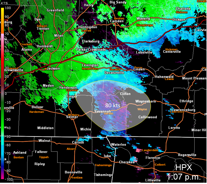
The radar measures winds to or from the radar. In the images below the radar from Columbus and Fort Campbell show wind speeds over 80 kt (92 mph) several thousand feet above the ground.
Columbus radar from 12:47 p.m. showing over 90 mph winds in the blue circle.
Fort Campbell radar from 1:07 p.m. showing over 90 mph winds in the white shaded area.
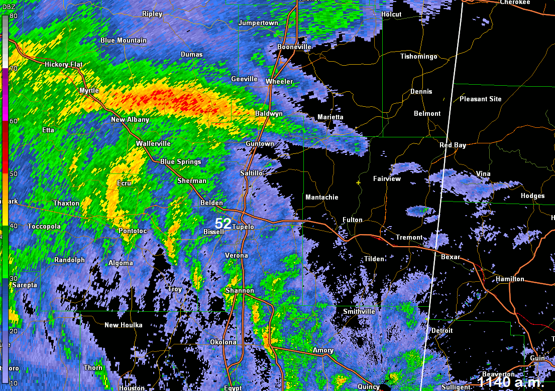
Loop of Wind gusts values at Tupelo and radar from Columbus
Storm Reports:
PRELIMINARY LOCAL STORM REPORT...SUMMARY
NATIONAL WEATHER SERVICE MEMPHIS TN
904 AM CDT TUE OCT 29 2019

..TIME...   ...EVENT...      ...CITY LOCATION...     ...LAT.LON...
..DATE...   ....MAG....      ..COUNTY LOCATION..ST.. ...SOURCE....
            ..REMARKS..

1040 AM     TSTM WND DMG     HOUSTON                 33.90N  89.00W
10/26/2019                   CHICKASAW          MS   EMERGENCY MNGR

            TREES DOWN THROUGHTOUT THE COUNTY. ALSO SOME POWERLINES
            KNOCKED DOWN.

1111 AM     TSTM WND DMG     PONTOTOC                34.25N  89.01W
10/26/2019                   PONTOTOC           MS   EMERGENCY MNGR

            2 SEMI TRUCKS BLOWN OVER ON HWY 278. WINDS ESTIMATED AT
            70 MPH. TREES DOWN AND POWER LINES DOWN. 4 ROADS CLOSED
            BUT OPENED WITHIN 2 HOURS. 10 TO 15 HOMES DAMAGED BY
            WIND AND TREES FALLING DOWN ON THEM.

1140 AM     TSTM WND GST     5 SE RIPLEY             34.68N  88.88W
10/26/2019  M74 MPH          TIPPAH             MS   TRAINED SPOTTER

            WINDS CAUSED ROOF DAMAGE TO MANY STRUCTURES ALONG WITH
            LOTS OF TREES DOWN.

1142 AM     TSTM WND DMG     4 NE DUMAS              34.67N  88.78W
10/26/2019                   TIPPAH             MS   EMERGENCY MNGR

            NUMEROUS TREES DOWN...ESPECIALLY ALONG CR 600.

1146 AM     TSTM WND GST     2 WNW TUPELO            34.28N  88.77W
10/26/2019  M60 MPH          LEE                MS   ASOS

            ASOS REPORTED WIND GUST OF 52 KT.

1200 PM     TSTM WND DMG     1 SW TUPELO             34.25N  88.74W
10/26/2019                   LEE                MS   TRAINED SPOTTER

            TREES UPROOTED AND SNAPPED.

1208 PM     TSTM WND GST     2 WNW TUPELO            34.28N  88.77W
10/26/2019  M71 MPH          LEE                MS   ASOS

            ASOS MEASURED 62KT GUST.

1231 PM     TSTM WND DMG     1 NE TUPELO             34.27N  88.72W
10/26/2019                   LEE                MS   COUNTY OFFICIAL

            TREE DOWNED ALONG ELVIS PRESLEY DRIVE.

1240 PM     TSTM WND DMG     4 NNW PICKWICK DAM      35.11N  88.28W
10/26/2019                   HARDIN             TN   SOCIAL MEDIA

            NUMEROUS TREES DOWN IN NIXON.

1248 PM     TSTM WND DMG     CORINTH                 34.94N  88.52W
10/26/2019                   ALCORN             MS   PUBLIC

            TREES DOWN AND SHINGLES BLOWN OFF ROOF.

0100 PM     TSTM WND DMG     CORINTH                 34.94N  88.52W
10/26/2019                   ALCORN             MS   TRAINED SPOTTER

            MULTILPE TREES DOWN ALONG WITH POWER LINES THROUGHOUT
            ALCORN COUNTY. SIGNS ALSO BLOWN DOWN.

0113 PM     TSTM WND DMG     MICHIE                  35.06N  88.43W
10/26/2019                   MCNAIRY            TN   PUBLIC

            TREES DOWN AND POWER LINES DOWN. SOME HOUSE DAMAGE DUE
            TO TREES DOWN.

0114 PM     TSTM WND GST     3 SE IUKA               34.78N  88.17W
10/26/2019  M70 MPH          TISHOMINGO         MS   MESONET

            TISHOMINGO RAWS.

0120 PM     TSTM WND DMG     2 W SAVANNAH            35.22N  88.27W
10/26/2019                   HARDIN             TN   SOCIAL MEDIA

            SHINGLES OFF ROOF.

0130 PM     TSTM WND DMG     ADAMSVILLE              35.23N  88.39W
10/26/2019                   MCNAIRY            TN   SOCIAL MEDIA

            *** 1 FATAL *** ON PERKINS ROAD IN ADAMSVILLE A LARGE
            TREE FELL ON AND KILLED A 64 YEAR OLD MAN.

0153 PM     TSTM WND DMG     MILLEDGEVILLE           35.38N  88.37W
10/26/2019                   MCNAIRY            TN   AMATEUR RADIO

            TREES ON HOUSES

0154 PM     TSTM WND DMG     DECATURVILLE            35.58N  88.12W
10/26/2019                   DECATUR            TN   SOCIAL MEDIA

            SEVERAL TREES DOWN AND POWER POLES DAMAGED IN
            DECAUTARVILLE.

0155 PM     TSTM WND DMG     PARSONS                 35.65N  88.12W
10/26/2019                   DECATUR            TN   TRAINED SPOTTER

            MULTIPLE TREES AND POWER LINES DOWN IN AND AROUND THE
            CITY OF PARSONS.

0207 PM     TSTM WND GST     4 W CAMDEN              36.07N  88.17W
10/26/2019  M58 MPH          BENTON             TN   MESONET

            CAMDEN TOWER RAWS.

0230 PM     TSTM WND DMG     14 S CAMDEN             35.86N  88.10W
10/26/2019                   BENTON             TN   SOCIAL MEDIA

            7 SEMI TRUCKS BLOWN OVER ON I-40 BRIDGE OVER TENNESSEE
            RIVER IN BENTON COUNTY. WINDS WERE ESTIMATED TO BE 70
            MPH.

0230 PM     TSTM WND DMG     DECATURVILLE            35.58N  88.12W
10/26/2019                   DECATUR            TN   BROADCAST MEDIA

            *** 1 INJ *** A LARGE TREE FELL ON TRAILER HOME AND CAR
            IN RURAL DECATUR COUNTY. A WOMAN WAS CRITICALLY INJURED.

