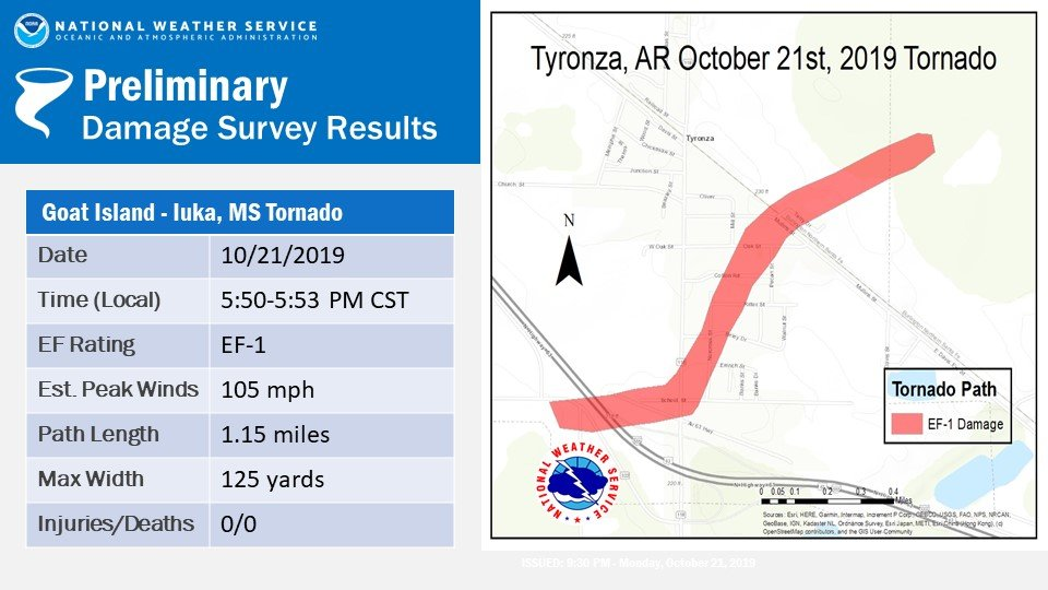
...NWS Damage Survey For Tyronza Tornado Event...

Rating: EF-1
Estimated Peak Wind: 105 MPH
Path Length /Statute/: 1.15 Miles
Path Width /Maximum/: 125 yards
Fatalities: 0
Injuries: 3

Start Date: Oct 21 2019
Start Time: 550 am CDT
Start Location: 1 SW Tyronza
Start Lat/Lon: 35.4827/-90.3644

End Date: Oct 21 2019
End Time: 553 am CDT
End Location: 1 NE Tyronza
End Lat/Lon: 35.4915/-90.3479

SURVEY SUMMARY:
Short track tornado. There was straight line wind damage
surrounding the tornado. Primarily damage to a convenient store
and elementary school. Several outbuildings were destroyed.
Numerous trees down.
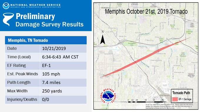
...NWS Damage Survey For Memphis Tornado Event - Update 1...

Rating: EF-1
Estimated Peak Wind: 105 MPH
Path Length /Statute/: 7.4 Miles
Path Width /Maximum/: 250 yards
Fatalities: 0
Injuries: 0

Start Date: Oct 21 2019
Start Time: 634 am CDT
Start Location: Memphis
Start Lat/Lon: 35.0452/-89.9839

End Date: Oct 21 2019
End Time: 643 am CDT
End Location: East Memphis
End Lat/Lon:  35.0855/-89.8623

SURVEY SUMMARY:
Primary damage to Cottonwood Apartments with significant roof
damage. Numerous trees and business signs down. Tornado began from
the Memphis Airport to Balmoral area of East Memphis
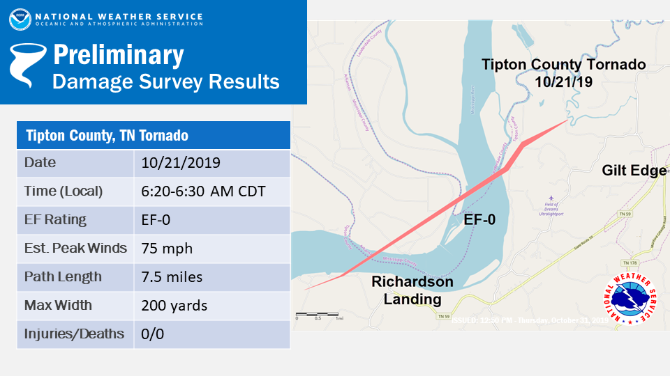
...NWS Damage Survey For Tipton County...

Rating: EF-0
Estimated Peak Wind: 75 mph
Path Length /Statute/: 7.5 miles
Path Width /Maximum/: 200 yards
Fatalities: 0
Injuries: 0

Start Date: Oct 21 2019
Start Time: 620 am CDT
Start Location: Richardsons Landing
Start Lat/Lon: 35.5095/-89.9776

End Date: Oct 21 2019
End Time: 630 am CDT
End Location: 2 miles NW of Gilt Edge
End Lat/Lon: 35.5690/-89.8642

SURVEY SUMMARY:
Tornado touched down in farmlands near the Mississippi River.
Tornado tracked intermittingly and continued northeast across the
Mississippi River breaking tree limbs and uprooting a few trees
before lifting south of the Hatchie River northwest of Gilt Edge.
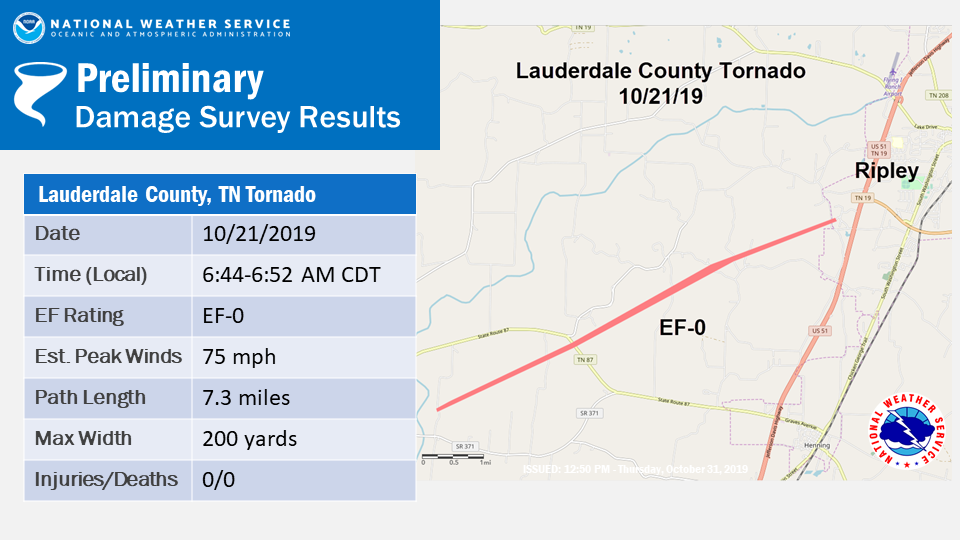
...NWS Damage Survey For Lauderdale County...

Rating: EF-0
Estimated Peak Wind: 75 mph
Path Length /Statute/: 7.3 miles
Path Width /Maximum/: 200 yards
Fatalities: 0
Injuries: 0

Start Date: Oct 21 2019
Start Time: 644 am CDT
Start Location: 8 SW of Ripley
Start Lat/Lon: 35.6811/-89.6854

End Date: Oct 21 2019
End Time: 652 am CDT
End Location: 1 SW of Ripley
End Lat/Lon: 35.7268/-89.5679

SURVEY SUMMARY:
Tornado touched down in southern Lauderdale County and tracked northeast
toward Ripley, lifting before reaching the town. Large tree limbs were
broken and a few trees were uprooted. There was minor roof damage to one
home.
NOTE: Information above is preliminary and subject to change pending final review of the event and publication in NWS Storm Data.

