NOUS44 KMEG 010107
PNSMEG
ARZ009-018-026>028-035-036-048-049-058-MOZ113-115-MSZ001>017-
020>024-TNZ001>004-019>022-048>055-088>092-011300-

Public Information Statement
National Weather Service Memphis TN
805 PM CDT Thu Mar 31 2022

...NWS Damage Survey For 03/30/2022 Tornado Event - Update 2...

.OVERVIEW...
A survey of the damage from Wednesday evening`s thunderstorms
resulted in three confirmed tornadoes in West Tennessee. These
tornadoes affected areas in Madison, Gibson, and Carroll Counties.
In addition to these tornadoes, widespread damage from straight-
line winds exceeding 80 mph was surveyed. Tree damage was widespread
with several homes sustaining roof damage. Numerous utility poles
were downed as well. Additional information may result in changes to
this preliminary information.
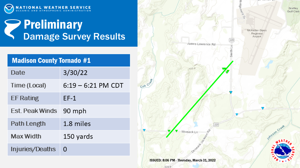
.Tornado #1 in Denmark, Tennessee...

Rating: EF-1 Estimated Peak Wind: 90 MPH Path Length /Statute/: 1.8
miles Path Width /Maximum/: 150 yards Fatalities: 0 Injuries: 0

Start Date: 03/30/22 Start Time: 6:19 PM CDT Start Location: 35.5713
Start Lat/Lon: -88.9469

End Date: 03/30/22 End Time: 6:21 PM End Location: 35.5914 End
Lat/Lon: -88.9254

SURVEY SUMMARY:

A brief tornado developed just south of Womack Lane to the west of
Denmark-Jackson Road. Damage was observed to two homes on Womack
Lane, one with significant roof damage. Numerous trees were uprooted
or snapped as this tornado moved northeast across rural, wooded
land. Additional damage was observed at the Pacific Manufacturing
facility on Smith Lane where the east-facing wall of a large metal
building was peeled off of the frame. Several large rolling doors
were blown in at this facility. There were also several metal power
poles that were severely bent along Smith Lane. Additional damage
was observed farther to the northeast across the southern portion of
Jackson, but this is currently believed to be due to straight-line
winds. This includes several businesses damaged along Airways
Boulevard just to the east of the South Fork of the Forked Deer
River and the numerous trees down across the city.
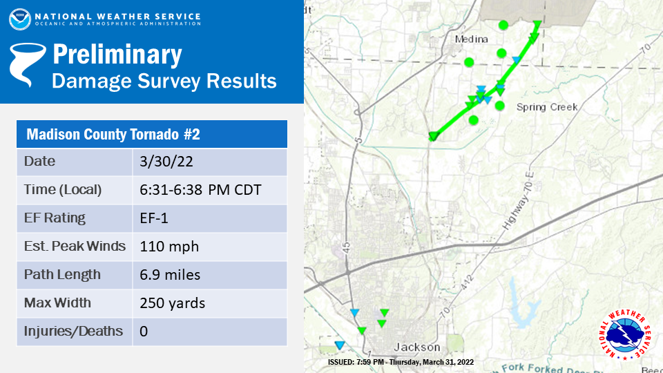
.Tornado #2 near Medina, Tennessee...

Rating: EF-1 Estimated Peak Wind: 110 MPH Path Length /Statute/: 6.9
miles Path Width /Maximum/: 250 yards Fatalities: 0 Injuries: 0

Start Date: 03/30/22 Start Time: 6:31 PM CDT Start Location: 35.8173
Start Lat/Lon: -88.7095

End Date: 03/30/22 End Time: 6:38 PM CDT End Location: 35.7450 End
Lat/Lon: -88.7915

SURVEY SUMMARY:

The tornado caused damage along an intermittent track with several
short-lived touchdowns over the nearly 7 mile path. The initial
touchdown occurred near intersection of Old Medina Road and Barnes
Road, where 2 houses sustained considerable damage.

The first house on the corner had the majority of its roof removed,
the garage doors blown in, and an outbuilding nearly destroyed.
Debris was lofted and deposited in the forest downstream.

Another house, which was located northeast of the corner house,
sustained minor roof damage. Nearly all windows on the front and
back of the house were blown out. The house and a couple of vehicles
on the property received damage from flying debris lofted from the
corner house. The tornado lifted very shortly after affecting these
homes.
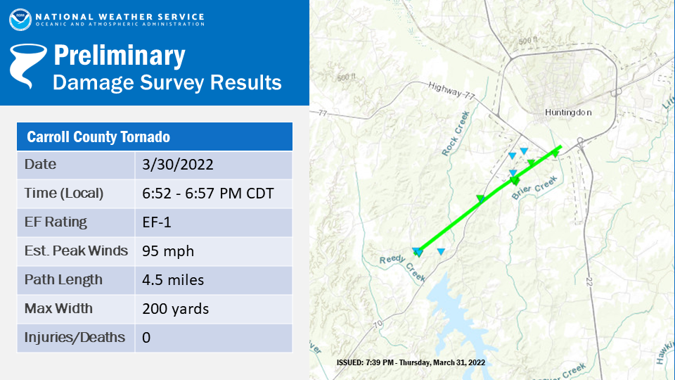
.Tornado #3 in Huntingdon, Tennessee...

Rating: EF-1 Estimated Peak Wind: 95 MPH Path Length /Statute/: 4.5
miles Path Width /Maximum/: 200 yards Fatalities: 0 Injuries: 0

Start Date: 03/30/22 Start Time: 6:52 PM CDT Start Location: 35.9525
Start Lat/Lon: -88.4832

End Date: 03/30/22 End Time: 6:57 PM End Location: 35.9907 End
Lat/Lon: -88.4187

SURVEY SUMMARY:

The tornado initially touched down south of Voss Lane to the west of
Highway 70, resulting in significant tree damage. The tornado
tracked northeast, crossing Highway 70 north of Tate Loop causing
significant damage on the south end of Skyline Lane. Several houses
sustained roof damage, blown out windows, and widespread tree
damage. The tornado continued northeast crossing Veterans Drive
South before dissipating near Lexington Street.


...NWS Damage Survey For 03/30/2022 Tornado Event - Update 2...

.OVERVIEW...

A survey of the damage from the thunderstorms on Wednesday
evening resulted in a confirmed tornado in Northwest Mississippi.
This tornado affected areas in Panola County. Widespread fallen
trees caused significant structural damage to several houses,
including roof and siding damage. Tornadic winds in excess of 100
mph have been estimated from the extent of the damage.
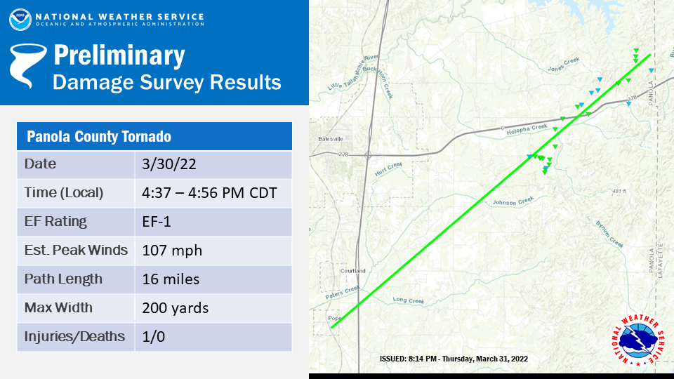
.Tornado #4 in Southeastern Panola County, MS... Rating: EF-1 Estimated Peak Wind: 107 mph Path Length /Statute/: 16 miles Path Width /Maximum/: 200 yards Fatalities: 0 Injuries: 1 Start Date: 3/30/2022 Start Time: 4:37 PM CDT Start Location: Pope / Panola County / MS Start Lat/Lon: 34.211 / -89.945 End Date: 3/30/2022 End Time: 4:56 PM CDT End Location: 3 W Burgess / Panola County / MS End Lat/Lon: 34.358 / -89.724 SURVEY SUMMARY: An NWS damage survey crew confirmed that last night`s thunderstorms produced an EF-1 tornado from Pope, MS to just south of Sardis Lake, MS. This tornado started just west of Interstate 55 in Pope, MS, causing widespread tree damage and even uprooting a large tree onto a home. Several utility poles were snapped with loose power lines hanging down over roads. As the tornado moved northeast, it likely peaked in intensity as it damaged several homes off of De Bowen Wilson Rd and crossed over Hwy 6. Multiple large trees were snapped at the trunks and several others were twisted and/or uprooted. A mobile home off Hwy 6 was severely damaged and caused one injury. After the tornado crossed over Hwy 6, it moved towards Sardis Lake. Numerous large tree branches and utility poles were snapped, as well as several trees uprooted. The easternmost part of the damage found by the survey crew appeared to be on Sardis Lake Drive, where fallen trees caused significant roof and siding damage to a few houses. The tornado likely lifted just west of the Panola/Lafayette County line..Tornado #5 in Calhoun County, MS... Rating: EF-1 Estimated Peak Wind: 90 MPH Path Length /Statute/: 7.7 miles Path Width /Maximum/: 100 yards Fatalities: 0 Injuries: 0 Start Date: 03/30/22 Start Time: 0524 PM CDT Start Location: 4.5 Miles NNW Bruce Start Lat/Lon: 34.0492 /-89.3786 End Date: 03/30/22 End Time: 0532 PM CDT End Location: 1 Mile NE Sarepta End Lat/Lon: 34.1289 /-89.2863 SURVEY SUMMARY: The tornado initially touched down on County Road 271 just southwest of Highway 9 West. Several large trees were uprooted in the area, a home received minor damage, and a couple of outbuildings had their roofs partially removed. The tornado continued northeast over a densely forested area to Highway 9. Along Highway 9, 20 power poles were destroyed and numerous trees were uprooted or snapped. The tornado continued directly along highway 9 damaging several homes and outbuildings, uprooting and snapping numerous trees, and a shifted a mobile off its blocks. The tornado continued along highway 9 and lifted just northeast of the town of Sarepta. Straight-line wind damage was observed southwest of the tornado track near Highway 32 in the community of Ellard. EF Scale: The Enhanced Fujita Scale classifies tornadoes into the following categories: EF0...Weak......65 to 85 mph EF1...Weak......86 to 110 mph EF2...Strong. ..111 to 135 mph EF3...Strong....136 to 165 mph EF4...Violent...166 to 200 mph EF5...Violent...> 200 mph NOTE: Information in this statement is preliminary and subject to change pending final review of the event and publication in NWS Storm Data.
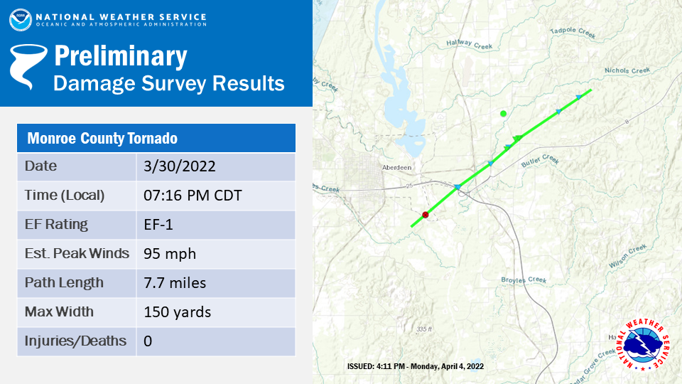
.Tornado in Monroe County, Mississippi...

Rating: EF-1
Estimated Peak Wind: 95
Path Length /Statute/: 7.7 miles
Path Width /Maximum/: 150 yards
Fatalities: 0
Injuries: 0

Start Date: 03/30/22
Start Time: 07:16 PM CDT
Start Location: 3 SE Aberdeen / Monroe County / MS
Start Lat/Lon: 33.7970 / -88.5221

End Date: 03/30/22
End Time: 07:26 PM CDT
End Location: 6 WSW Greenwood Springs / Monroe County / MS
End Lat/Lon: 33.8648 / -88.4163

SURVEY SUMMARY:

A tornado developed approximately 3 miles southeast of Aberdeen
near a wooded area along Sharpley Bottom Road per a tornadic
debris signature. As this tornado moved northeast, tree damage was
immediately northwest of the intersection of Highways 45 and 25
South near East Aberdeen. More uprooted trees were observed along
Highway 25 South near Nichols Creek. The tornado intensified as it
crossed Dan Taylor Road and Old Columbus Road, snapping and
uprooting hardwood trees, indicative of wind speeds near 95 mph.
The tornado continued northeast, resulting in minor tree damage
along Burns Cemetery Road and Beeks Road, dissipating in the
wooded area prior to reaching West Road. Thanks to NSSL for
assistance with this damage survey.

$$

AC3/MJ/SWB/CAD/TLS JR

