|
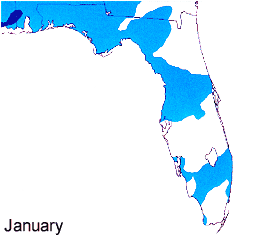
January Lightning Plot
(Flashes per square kilometer)
During the month of January, very little lightning occurs over the state of Florida. For the most part, the distribution of flash densities are governed largely by the passage of mid-latitude synoptic-scale systems such as consecutively active cold fronts. The maximum located over the panhandle is due to warm moist air from the gulf interacting with synoptic scale systems. As these systems move northeast, lightning activity decreases as the dynamics move off the east coast.
Back to Top
|
|
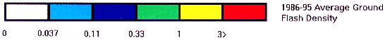
February Lightning Plot
(Flashes per square kilometer)
During the month of February, very little change occurs overall compared to January, as the lightning activity is still driven by mid latitude disturbances.
Back to Top
|
|
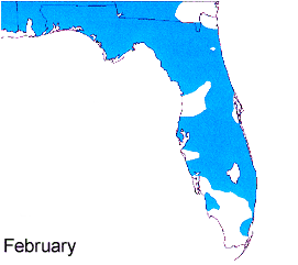
March Lightning Plot
(Flashes per square kilometer)
Things begin to change in February. It is during this time of the year that the state of Florida, especially the peninsula, sees most of its' significant severe weather. Likewise, an increase of lightning activity is observed. Down over South Florida, these convective systems have less of a influence and likewise less lightning.
Back to Top
|
|
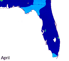
April Lightning Plot
(Flashes per square kilometer)
During April, the flash densities continue to increase, especially over the peninsula. This is due to the continued influence of synoptic systems and an increasing sun angle. Sea breeze forcing is also beginning to occur over the region, especially along the coastal sections over the peninsula. It is interesting to note that although lightning has increased over the state from the months gone by, the month of April is the driest month of the year for Florida.
Back to Top
|
|
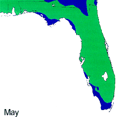
May Lightning Plot
(Flashes per square kilometer)
May shows a rapid increase of lightning over the state. Although synoptic influences are rapidly decreasing, a few significant events due occur as weak short waves move across an unstable atmosphere over the state. However, the main contribution to lighting is due to the developing thunderstorms associated with the sea breezes.
Back to Top
|
|
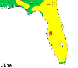
June Lightning Plot
(Flashes per square kilometer)
During the month of June, the flash rates over the peninsula begin to dominate. This is due to the two seabreezes which develop along the east and west coast. Although a sea breeze develops along the coast along the panhandle, it is the collision of the two sea breezes over the peninsula which cause the high flash rates during June and the remainder of the summer season. This plot also shows local influences of the geography influencing the flash rates as a maximum is indicated west of Tampa.
The minimum over south Florida is due to a combination of reasons. One of these reasons is due to the combination of the narrowness of the peninsula in this location and the low level easterlies being deeper over South Florida. These two factors combine to force the east coast sea breeze to move quickly west towards the west coast. this quick movement of the sea breeze does not allow the atmosphere to destabilize enough for storms to develop. In addition this area is covered by the Everglades which is slightly cooler and likewise less unstable then the remainder of the state. Another possible reason for the minimum is due to the subtropical ridge over this location, especially in the Summer months. It is interesting to note that the minimum over the South part of the state is noticeable on nearly all of the monthly plots.
Back to Top
|
|
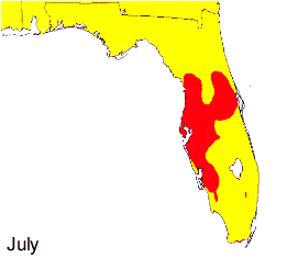
July Lightning Plot
(Flashes per square kilometer)
July is the month for Lightning over the state of Florida! The combination of warm coastal waters and near maximum insolation allows for both sea breezes to become well developed over the peninsula. The maximum over the central part of the peninsula is due to the location of the subtropical ridge axis over the region. Typically, this axis is located over the north central part of the peninsula. On a long term average, the sea breeze along the east coast will move in quickly along the southern part of the east coast while up north it will only move in slowly inland, or not at all. Over on the west coast, the southern section of the west coast sea breeze will move in only slowly while up north the boundary will move relatively quickly inland. As the day progresses, the differential motion of the sea breezes will allow for a collision process to occur NE/SW over the central part of the peninsular region.
Back to Top
|
|
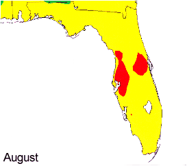
August Lightning Plot
(Flashes per square kilometer)
August is still very active over the State of Florida, with the same general pattern as July, however there is a slight decrease in overall activity. This decrease is due to two factors: The first is decreasing insolation, which decreases the instability somewhat over the state. the second factor is the subtropical ridge building over the area aloft. During this time of the year, the subtropical ridge is at its farthest location pole ward, which helps stabilize the atmosphere aloft.
Back to Top
|
|
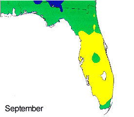
September Lightning Plot
(Flashes per square kilometer)
September shows a significant decrease in lighting activity statewide. The reason is due to the influence of frontal systems over the southeastern United States. Monthly wind plots for stations over Florida indicate the average wind flow has shifted from the southeast to the northeast (except for the southern 1/3 of the state in which southeast flow still predominates). The shift in wind flow is due to high pressure systems building in from the north which shifts the low level wind field to the northeast. Another reason for decreasing flash rates is due to decreasing insolation.
Back to Top
|
|
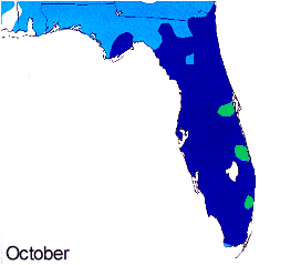
October Lightning Plot
(Flashes per square kilometer)
During October, the most noticeable flash maximums occur in areas along the east coast from the Cape on south. This is due to convectively active heavy rain events which occur during this time of the year on the east coast. These heavy rain events occur when frontal systems stall over the region allowing for localized areas of convergence to set up. It is believed that the subtropical jet also plays a role in the vertical motion fields. In addition, local seabreeze thunderstorms still develop which account for the relative maximum over the peninsula.
Back to Top
|
|
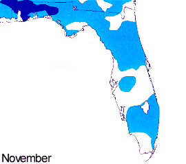
November Lightning Plot
(Flashes per square kilometer)
Lightning flash rates drop dramatically in November as high pressure systems bring dry air to the state of Florida. Once again the panhandle area/northern peninsula shows a relative maxima in lighting activity, and this is due to transient frontal systems moving across the region.
Back to Top
|
|
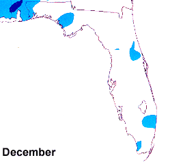
December Lightning Plot
(Flashes per square kilometer)
The month of December shows the least amount of lightning activity over the state of Florida. This is due to the minimal amount of solar insolation and very stable air advected in from high pressure centers moving in from the continental United States.
Back to Top
|
|
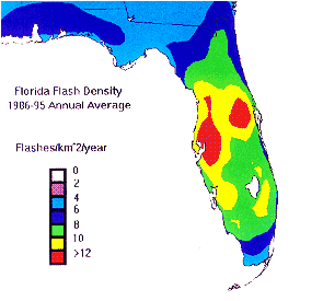
Annual Lightning Plot
Back to Top
.
|


