Overview
|
A southward moving cold front tracked across central and southern MN early Monday morning before stalling near Redwood Falls, MN over to Eau Claire, WI. Morning stratus associated with this frontal boundary aided an increased thermal gradient along this boundary. Later in the afternoon, a surface low centered over eastern Nebraska advected unstable air into much of southern MN. This airmass converged on the pre-existing stationary boundary which led to the initiation of several severe thunderstorms. Many thunderstorms produced large to very large hail measuring as large as 3.5" in diameter as well as tornadoes. |
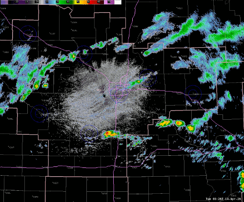 KMPX Radar Reflectivity from April 13th, 2026. |
Tornadoes
Four tornadoes occurred across south central Minnesota. The first tornado, north-northwest of Truman, has been rated EF-U (unknown intensity since it didn't hit anything). The tornado between Truman and Amboy has been rated EF-1. The tornado west of Elmore has been given a rating of EF-1, and the rating for the tornado in extreme northwest Freeborn County has been rated EF-1.
The first tornado, 3 miles north-northwest of Truman, was caught on video by several storm chasers. Path length was approximately 2/3 mile and it lasted from 6:12 p.m. to 6:13 p.m. CDT. The maximum width is estimated at 25 yards. It moved over open fields and didn't hit anything, so it's rating is EF-U (unknown).
The second tornado began two miles north of Truman and tracked east to about 5 miles west of Amboy. Ground contact began at 6:15 p.m. CDT and the tornado dissipated at approximately 6:40 PM after being mostly on the ground for 8.5 miles. The rating is EF-1 with estimated maximum winds of 90 mph. The tornado mostly moved across open fields, but it did hit four houses and some groves of trees. One house had garage doors blown out, patio lights blown out of the soffits, sporadic shingle damage, while outbuildings had shed doors blown out along with some other damage. Another farm had a small building lifted off the foundation and dropped down 30 yards away. One other location had an enclosed trailer picked up and deposited across the field. The tornado was on the ground most of the way, but there were three separate times when it did not make ground contact for a minute or two. The same parent circulation, however, persisted along the entire path; Storm Data allows this to be documented as one tornado. This determination has been based on many, many videos from storm chasers as well as damage photos provided by the Blue Earth County Sheriff's Office. It is certainly possible that this may change if new information becomes available. The maximum width is estimated at 200 yards and video showed it to be a multiple vortex tornado at times.
Farther south, starting at 7:15 PM six miles west of Elmore, MN, a tornado was caught on video/photos by at least two storm chasers. It hit a farm, with one building losing 6-10 tin panels from its roof and having garage doors blown in. Some trees were also damaged. It has been rated EF-1 with estimated maximum winds of 90 mph. Path length was 4.5 miles, and it dissipated 1.5 miles west-northwest of Elmore.
At approximately 8:05 PM, a tornado was reported in northwest Freeborn County, just under 3 miles SE of Matawan, MN. The tornado destroyed three farm outbuildings and removed much of a shed's roof. Debris was blown over one mile away. The tornado snapped or damaged dozens of trees. This tornado was rated an EF-1 with estimated maximum winds of 105 mph. Path length was 2.7 miles, and it dissipated 4.5 miles NW of Hartland.
Select a tornado from the table to zoom into the track and view more information. The default table view is limited to 8 tracks, but can be scrolled by a mouse wheel or dynamically expanded. Additionally, the table can fill the entire window by clicking the small circular expanding arrow icon at the very top right of the table and returned to its original size by clicking the button again. The side information panel that opens over the map can be closed using the "X" on the upper right corner of the pop-up. Zoom into the map and click damage points to see detailed information and pictures from the surveys.
Select a tornado from the table to zoom into the track and view more information. The default table view is limited to 8 tracks, but can be scrolled by a mouse wheel or dynamically expanded. Additionally, the table can fill the entire window by clicking the small circular expanding arrow icon at the very top right of the table and returned to its original size by clicking the button again. The side information panel that opens over the map can be closed using the "X" on the upper right corner of the pop-up. Zoom into the map and click damage points to see detailed information and pictures from the surveys.
|
NOTE: times shown below are local to your device's time zone. |

The Enhanced Fujita (EF) Scale classifies tornadoes into the following categories:
| EF0 Weak 65-85 mph |
EF1 Moderate 86-110 mph |
EF2 Significant 111-135 mph |
EF3 Severe 136-165 mph |
EF4 Extreme 166-200 mph |
EF5 Catastrophic 200+ mph |
 |
|||||
| Tornadoes that fail to impact any ratable damage indicators on the EF-Scale are rated EF-Unknown (EF-U) | |||||
Hail
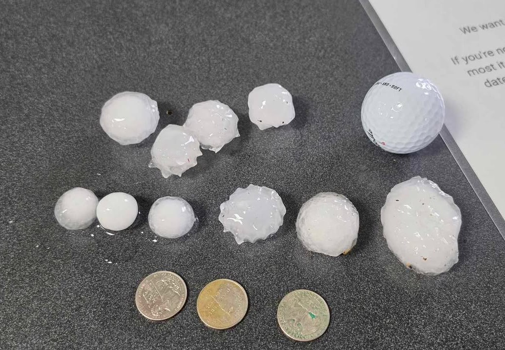
Many storms from this event produced considerably large hail with varied diameters from quarter size up to just smaller than softball. Of the 50+ hail measurements our office received, five reports consisted of hailstones at or greater than 3" diameter. The largest hail stone measured at 3.5" diameter in Lake Crystal, MN (Blue Earth County). The second largest was 3.3" diameter in Dennison, MN (Goodhue County). The third largest hail stones at 3" diameter were measured near Faribault, MN (Rice County) and near Morristown, MN (Steele County).
 |
 |
 |
.png) |
|
3" diameter hail measurement south of Hanska, MN (Brown Co). |
Multiple large hailstones in Faribault, MN. Courtesy of Annelisa Brown |
2" diameter hail measurement in St. Peter, MN. Courtesy of Jamison Willis |
Plate of large hailstones collected near Urland Church along Goodhue Cty 9. Courtesy of Jim Braaten |
 |
.png) |
 |
.jpeg) |
| Photo of hail accumulation near Lake City, MN (Goodhue Co). Courtesy of Blaine Thomas |
Hail accumulation in Rice Co. Courtesy of Rice Co Emergency Management |
Hail damage to rear windshield of a car near St. Peter, MN and Cleveland, MN. Courtesy of Rachel Sirek Olmanson |
Photo of hail accumulation near Nerstrand, MN. Courtesy of Marcia Cronce |
Heavy Rain
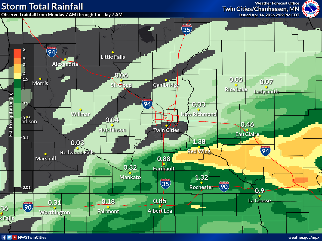
Thunderstorms also consisted of heavy downpours and rainfall amounts exceeding between 1 to 3 inches of rainfall. In south-central Eau Claire County, WI, localized flooding caused water to flow over a roadway just north of Eleva, WI.
 |
 |
| Map of the storm total rainfall from this event. | Water over Lowes Creek Rd just west of STH93 in south central Eau Claire Co. Courtesy of Timothy McCaughey |
Storm Reports
Below is a map of the local storm reports associated with this event. More information pertaining to each report can be found by clicking: IEM :: LSR from NWS MPX.
 |
| Map of the local storm reports across southern Minnesota and western Wisconsin. Courtesy of IEM LSR App |
 |
Media use of NWS Web News Stories is encouraged! Please acknowledge the NWS as the source of any news information accessed from this site. |
|

