Overview
|
A line of thunderstorms developed over western MN and progressed eastward during the evening of July 28th, 2025. As this line of storms reached eastern MN, storm intensity increased producing 60 to 70 mph damaging wind gusts across the Twin Cities metro down to Mankato. These storms the continued on into western WI and southeast MN. Reports of trees down and power outages were reported across several areas that the storm had moved through. A couple noteworthy measured gusts were at the Owatonna airport in Steele Co at 70mph, and Rochester airport in Olmstead County at 76 mph. Meanwhile, a second area of storms produced significant damaging wind across northern Iowa. The strongest wind gusts from this event were at the airport in Spencer, IA with 92 mph and airport near Waterloo, IA at 78 mph.
|
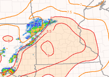
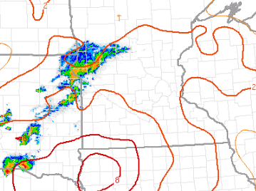
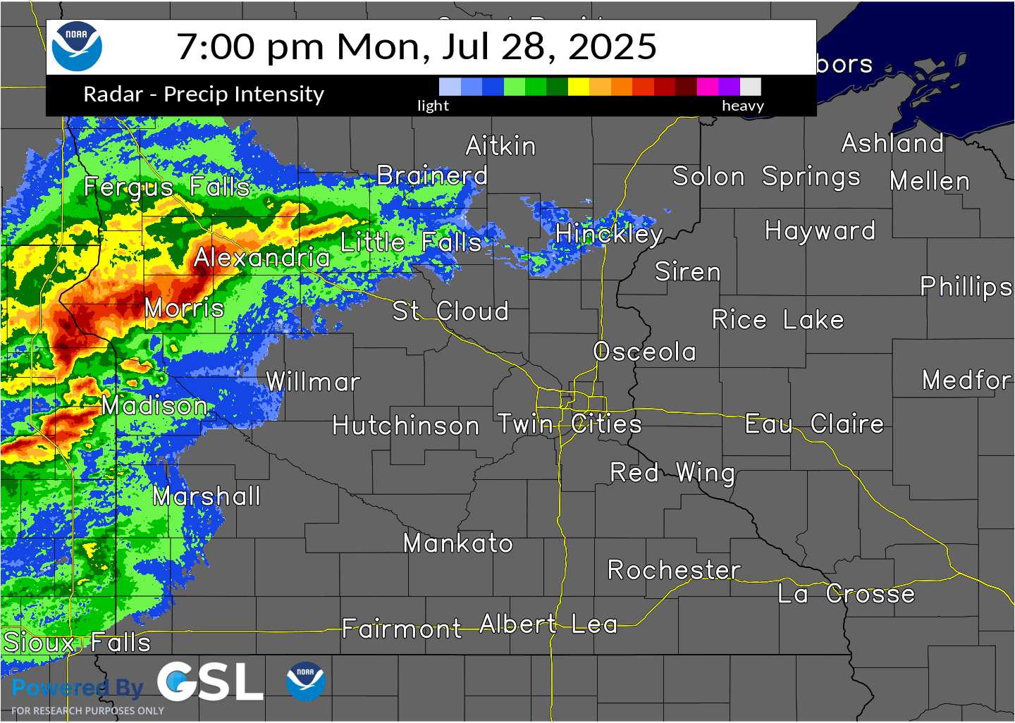 Radar reflectivity from 7:00 PM to 12:00 AM showing the storms move across the region. Most of the severe winds were reported as the storms approached the Twin Cities metro and moved south/east into Wisconsin. |
Environment
The near storm environment was driven primarily by large instability. This was due to steep mid level lapse rates overtop a warm and humid airmass south of a warm front. The storms developed across that Dakotas and western Minnesota, and moved into east/southeast during the late evening and overnight.
 |
 |
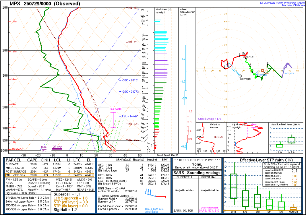 |
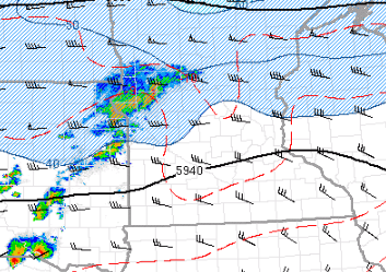
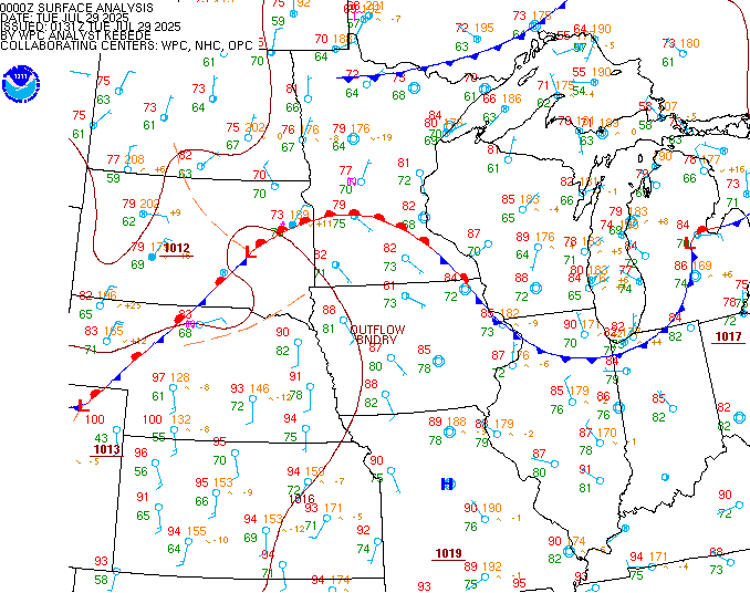
| July 29, 00Z 500mb heights and wind showing west-to-east flow across the Upper Midwest. | July 29, 00Z surface map showing a warm front across southern Minnesota. | July 29, 00Z forecast sounding from the NWS Twin Cities forecast office in Chanhassen MN showing steep mid level lapse rates, and increasing winds aloft. |
 |
 |
 |
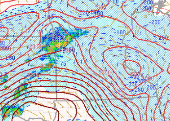
| July 29, 00Z 700mb to 500mb Lapse rates showing values 8.5 to 9 C/km! This allowed a strong cold pool to develop, which factored into the longevity of the system. | July 29, 00Z MLCAPE showing the highest values across northwest Iowa, with a gradient over southwest Minnesota. | July 29, 00Z Derecho Composite parameter was highest across northwest Iowa. This is the area where there were multiple observed wind gusts in excess of 90 mph! |
Storm Reports
Here is a link to severe weather reports, with summary LSR listed below. We'll continue to update those over as we receive more information.
Preliminary Local Storm Report...Summary
National Weather Service Twin Cities/Chanhassen MN
1219 AM CDT Tue Jul 29 2025
..TIME... ...EVENT... ...CITY LOCATION... ...LAT.LON...
..DATE... ....MAG.... ..COUNTY LOCATION..ST.. ...SOURCE....
..REMARKS..
0640 PM Hail 6 NW Donnelly 45.74N 96.10W
07/28/2025 M0.88 Inch Stevens MN Law Enforcement
0720 PM Tstm Wnd Dmg 6 ESE Browerville 46.05N 94.75W
07/28/2025 Todd MN Public
Along CR 29 north of Mill Lake. Portion of a
roof of a shed blown off. Fish house blown
around. Relayed by County Dispatch.
0725 PM Tstm Wnd Gst 7 S Alberta 45.47N 96.06W
07/28/2025 M55 MPH Stevens MN Storm Chaser
0738 PM Flash Flood Morris 45.58N 95.91W
07/28/2025 Stevens MN Law Enforcement
Multiple roads flooded in Morris, including
2 feet of water over County Road 22 and West
7th Street.
0909 PM Tstm Wnd Gst 2 SSW Hutchinson 44.86N 94.38W
07/28/2025 M60 MPH McLeod MN AWOS
Hutchinson airport.
0910 PM Tstm Wnd Dmg 1 WSW Elk River 45.31N 93.59W
07/28/2025 Sherburne MN Amateur Radio
Ten inch tree broken.
0918 PM Tstm Wnd Dmg Winsted 44.96N 94.05W
07/28/2025 McLeod MN Trained Spotter
Tree down on house. Time estimated based on
radar.
0929 PM Tstm Wnd Dmg Mayer 44.89N 93.88W
07/28/2025 Carver MN Trained Spotter
12 inch diameter tree snapped at the base.
0929 PM Tstm Wnd Gst 2 WSW Plato 44.76N 94.08W
07/28/2025 M59 MPH McLeod MN AWOS
Glencoe Airport.
0930 PM Tstm Wnd Dmg 1 NE Spring Lake Park 45.12N 93.23W
07/28/2025 Ramsey MN Public
Large tree down approximately 18 inches in
diameter. Near 85th Ave and Spring Lake Road
in Mounds View. Time estimated based on
radar.
0930 PM Tstm Wnd Dmg 1 SW Columbia Heights 45.04N 93.27W
07/28/2025 Anoka MN Amateur Radio
Tree down across much of Main St at 37th.
Time estimated based on radar.
0940 PM Tstm Wnd Dmg 1 W Dellwood 45.10N 93.00W
07/28/2025 Ramsey MN Amateur Radio
Two trees down on the north side of White
Bear Lake.
0945 PM Tstm Wnd Dmg 1 SSW Edina 44.89N 93.37W
07/28/2025 Hennepin MN Fire Dept/Rescue
Trees down, including some on Valley View
Rd. Time estimated based on radar.
0945 PM Tstm Wnd Gst 1 E Richfield 44.87N 93.25W
07/28/2025 M59 MPH Hennepin MN Trained Spotter
Measured by meteorologist.
0947 PM Tstm Wnd Gst 3 ENE Richfield 44.89N 93.23W
07/28/2025 M60 MPH Hennepin MN ASOS
Measured at MSP Airport.
0948 PM Tstm Wnd Dmg Somerset 45.13N 92.68W
07/28/2025 St. Croix WI Trained Spotter
Reports of several trees down in the Village
of Somerset. As well as reports of downed
power lines. Time estimated via radar.
0949 PM Tstm Wnd Gst 1 ESE Shakopee 44.79N 93.50W
07/28/2025 M65 MPH Scott MN Mesonet
Measured by Scott County mesonet.
0950 PM Tstm Wnd Dmg 1 NE Lake Elmo 45.02N 92.87W
07/28/2025 Washington MN Public
Three to four inch branches broken off of
healthy trees. Time estimated based on
radar.
0950 PM Tstm Wnd Dmg 1 W South St. Paul 44.89N 93.06W
07/28/2025 Dakota MN Amateur Radio
Tree down on Southview Blvd near Hwy 52.
0954 PM Tstm Wnd Gst Savage 44.76N 93.36W
07/28/2025 M62 MPH Scott MN Trained Spotter
0955 PM Tstm Wnd Dmg 1 S Somerset 45.11N 92.67W
07/28/2025 St. Croix WI Law Enforcement
Dozens of trees down, many of which were
across roads from Houlton to New Richmond.
0955 PM Tstm Wnd Dmg 2 WNW Eden Prairie 44.86N 93.47W
07/28/2025 Hennepin MN Public
Large tree downed in Eden Prairie. Photo
report via X.
0955 PM Tstm Wnd Dmg 1 SW Belle Plaine 44.62N 93.78W
07/28/2025 Scott MN Public
Report of downed maple tree in backyard.
0956 PM Tstm Wnd Gst 3 NNW New Prague 44.59N 93.59W
07/28/2025 M61 MPH Scott MN Mesonet
Corrects previous tstm wnd gst report from 3
NNW New Prague. Measured by Scott County
mesonet.
0956 PM Tstm Wnd Dmg 1 SE Belle Plaine 44.61N 93.75W
07/28/2025 Scott MN Trained Spotter
Large tree snapped in Belle Plaine. Photo
report via X. Time estimated radar.
1000 PM Tstm Wnd Gst 5 SW Prior Lake 44.66N 93.52W
07/28/2025 M55 MPH Scott MN Amateur Radio
Measured by weather station. Associated with
gust front.
1002 PM Tstm Wnd Gst 2 S Credit River 44.65N 93.38W
07/28/2025 M64 MPH Scott MN Trained Spotter
Measured at CR27 and Longview.
1004 PM Tstm Wnd Dmg 2 NE New Richmond 45.14N 92.51W
07/28/2025 St. Croix WI Trained Spotter
5 inch trees snapped in yard. Time
approximate.
1005 PM Tstm Wnd Dmg 1 SW New Richmond 45.11N 92.56W
07/28/2025 St. Croix WI Trained Spotter
Multiple trees larger than 1 foot in
diameter snapped or uprooted along 172nd
Avenue in New Richmond. Time estimated from
radar.
1005 PM Tstm Wnd Dmg Rosemount 44.74N 93.13W
07/28/2025 Dakota MN Public
Report of downed power lines near highway 3
in Rosemount. Time estimated from radar.
1010 PM Tstm Wnd Dmg Montgomery 44.44N 93.58W
07/28/2025 Le Sueur MN Trained Spotter
Large healthy pine tree snapped about 15
feet above ground, with its top resting on a
house. This was near the intersection of 3rd
Street NE and Linden Avenue. Large limbs
snapped nearby. Time estimated based on
radar.
1010 PM Tstm Wnd Dmg 1 NW Baldwin 44.97N 92.38W
07/28/2025 St. Croix WI Trained Spotter
Large tree branches down. Power out. Time
estimated by radar.
1012 PM Tstm Wnd Dmg Montgomery 44.44N 93.58W
07/28/2025 Le Sueur MN Trained Spotter
Report of multiple trees down near the high
school in Montgomery. Time estimated via
radar.
1015 PM Tstm Wnd Dmg Prescott 44.75N 92.79W
07/28/2025 Pierce WI Law Enforcement
Trees and power lines reported down.
1015 PM Rain 1 ENE Maple Plain 45.01N 93.65W
07/28/2025 M1.50 Inch Hennepin MN Trained Spotter
Measured 1.5 inches of rain in the
9:15-10:15PM timeframe.
1018 PM Tstm Wnd Gst 1 NW Baldwin 44.97N 92.38W
07/28/2025 M58 MPH St. Croix WI Trained Spotter
1025 PM Tstm Wnd Dmg Ellsworth 44.74N 92.48W
07/28/2025 Pierce WI Law Enforcement
Trees and power lines reported down.
1025 PM Tstm Wnd Dmg 1 SW Spring Valley 44.84N 92.26W
07/28/2025 Pierce WI Trained Spotter
Downed large tree blocking the road near Van
Buren and Silver Fox in Spring Valley. Time
estimated from radar.
1025 PM Hail 1 S Morristown 44.21N 93.44W
07/28/2025 M1.25 Inch Rice MN Trained Spotter
1027 PM Tstm Wnd Gst 3 NW Faribault 44.33N 93.31W
07/28/2025 M58 MPH Rice MN AWOS
At Faribault Airport. A three inch diameter
tree was reported down near the airport.
1035 PM Tstm Wnd Gst 2 WNW Bay City 44.59N 92.48W
07/28/2025 M58 MPH Pierce WI AWOS
Measured at Red Wing Airport.
1037 PM Tstm Wnd Gst 3 NW Bloomer 45.12N 91.54W
07/28/2025 M63 MPH Chippewa WI Public
Measured with home weather station. Several
branches down.
1040 PM Tstm Wnd Gst 3 NNW Owatonna 44.12N 93.26W
07/28/2025 M70 MPH Steele MN AWOS
Measured at Owatonna Airport.
1045 PM Tstm Wnd Dmg Menomonie 44.87N 91.93W
07/28/2025 Dunn WI Emergency Mngr
Trees and power lines reported down.
1050 PM Tstm Wnd Dmg 1 E Prior Lake 44.72N 93.40W
07/28/2025 Scott MN Public
Tree down across Cassandra St.
1100 PM Tstm Wnd Dmg 2 NW Durand 44.65N 91.99W
07/28/2025 Pepin WI Public
Tree down across road.
1100 PM Tstm Wnd Dmg 3 ESE Stockholm 44.46N 92.20W
07/28/2025 Pepin WI Law Enforcement
Several trees down across roads in the
Stockholm and Pepin areas.
1105 PM Tstm Wnd Dmg 4 ENE Durand 44.65N 91.90W
07/28/2025 Pepin WI Law Enforcement
Tree down across road.
1120 PM Tstm Wnd Dmg Eau Claire 44.82N 91.50W
07/28/2025 Eau Claire WI Law Enforcement
About one dozen trees across roads in
various parts of the city. Some power lines
also down.
Photos & Video
Header
 |
 |
 |
|
| Large tree snapped on northwest side of White Bear Lake. (Source: Jessie Kraemer) |
Another large tree snapped near White Bear Lake. (Source: Jessie Kraemer) |
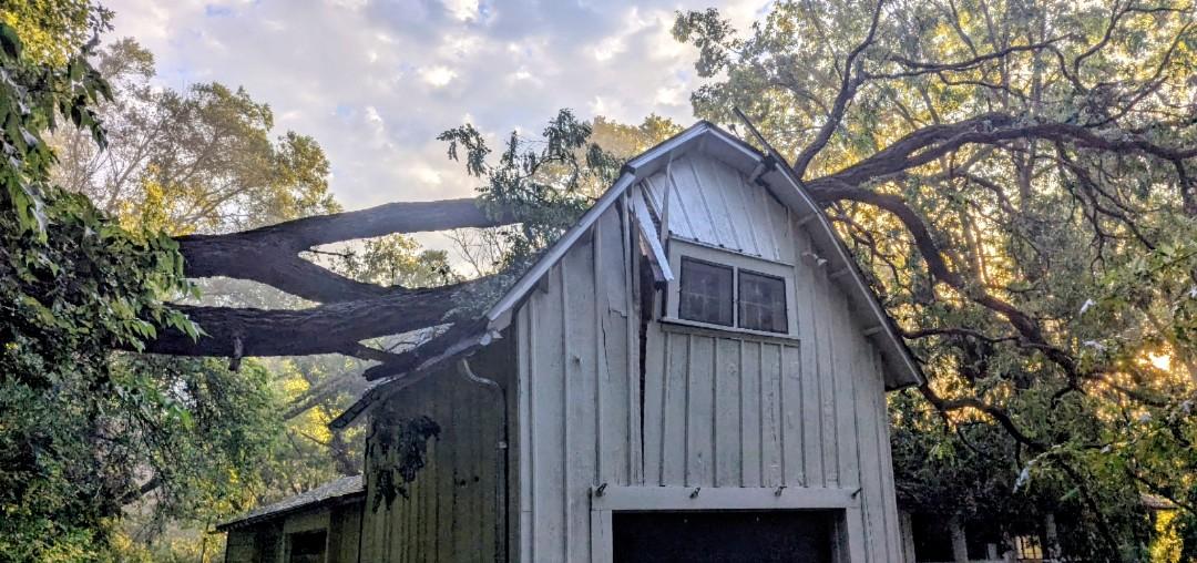
A tree that fell on a shed near Marine on St. Croix. (Source: Lee Borowska) |
Caption (source) |
 |
Media use of NWS Web News Stories is encouraged! Please acknowledge the NWS as the source of any news information accessed from this site. |
|

