Overview
|
The first significant lake effect snow took place late Wednesday night through early Thursday morning. Widespread 3-6 inches of snow with pockets of 8-12 inches fell across the northwest wind lake effect snow belts. Strong winds, at times gusting more than 40 mph, caused considerable blowing snow especially over exposed roadways, leading to difficult driving conditions and multiple car accidents. Cold air invaded the region late Wednesday night into Thursday, leading to below-zero wind chill temperatures across much of the area. This event signaled the beginning of the winter season to many. |
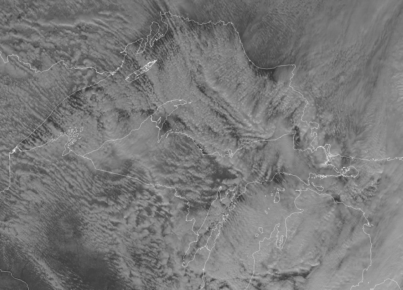 Visible satellite image from approximately 12:30 PM Thursday, 11/9, showing multiple lake effect snow bands across Lake Superior and Upper Michigan |
Snowfall Reports:
Here is a list of preliminary snowfall reports received during the event. The highest snowfall totals were confined to the northwestern snow belts, especially across Ontonagon and Houghton counties. Localized amounts in excess of 8 inches were also found across Marquette and Alger counties. The lake effect snow was more cellular in nature than expected (as opposed to developing into 1-3 dominant bands), leading to generally more widespread but less extreme snow totals. Even so, many areas saw their first significant snowfall of the year.
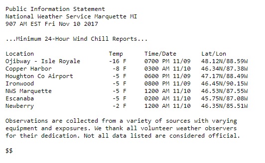
...48-Hour Storm Total Snowfall Reports...

Location                     Amount    Time/Date       Lat/Lon

...Alger County...
Eben Junction                9.4 in    0847 AM 11/10   46.35N/86.97W
1 SSE Chatham                7.0 in    0949 AM 11/10   46.33N/86.92W
Grand Marais                 5.0 in    0839 AM 11/10   46.67N/85.98W
Munising                     4.0 in    0630 AM 11/10   46.41N/86.66W

...Baraga County...
Herman                      11.0 in    1000 AM 11/10   46.67N/88.37W
3 ENE Prequaming             3.0 in    0713 AM 11/09   46.86N/88.34W
1 S Keweenaw Bay             4.3 in    0707 PM 11/09   46.84N/88.48W

...Delta County...
3 E Round Lake               9.0 in    0753 AM 11/10   46.15N/86.68W
3 SSW Brampton               1.0 in    0743 AM 11/09   45.88N/87.09W

...Gogebic County...
Ironwood                     5.5 in    0521 PM 11/09   46.45N/90.15W
Watersmeet 12WSW             4.0 in    0700 AM 11/10   46.22N/89.41W
2 WNW Ironwood               2.0 in    0700 AM 11/10   46.47N/90.19W
Bessemer                     2.0 in    0250 AM 11/09   46.48N/90.05W

...Houghton County...
1 SSW Allouez               11.5 in    0830 AM 11/09   47.28N/88.42W
Calumet                     11.0 in    0239 PM 11/09   47.25N/88.45W
Painesdale                  10.0 in    1113 AM 11/09   47.04N/88.67W
2 E Redridge                10.0 in    0900 AM 11/09   47.15N/88.72W
Hancock                      8.0 in    0827 AM 11/09   47.13N/88.60W
Houghton                     7.0 in    0704 AM 11/09   47.12N/88.56W
Twin Lakes                   6.0 in    0805 AM 11/09   46.90N/88.83W
Laurium                      6.0 in    0656 AM 11/09   47.24N/88.44W
Chassell                     6.0 in    0816 AM 11/09   47.03N/88.53W
Jacobsville                  4.1 in    0700 AM 11/10   47.01N/88.43W
6 ESE Chassell               2.6 in    0700 AM 11/10   46.99N/88.41W

...Keweenaw County...
Ahmeek                      10.0 in    0908 AM 11/09   47.30N/88.40W
Phoenix                      4.0 in    0248 AM 11/09   47.39N/88.28W

...Marquette County...
Marquette                    8.0 in    0700 AM 11/10   46.54N/87.40W
8 S Mountain Lake            7.2 in    0800 AM 11/09   46.75N/87.88W
10 SE Big Bay                7.0 in    0820 AM 11/09   46.70N/87.59W
Green Garden                 5.1 in    0512 AM 11/10   46.45N/87.30W
NWS Marquette                5.0 in    0700 AM 11/10   46.53N/87.55W
Harvey                       2.6 in    0841 AM 11/10   46.49N/87.35W
Clarksburg                   1.9 in    0700 AM 11/10   46.50N/87.84W
5 ESE Champion               1.2 in    0744 AM 11/10   46.49N/87.85W
4 NE Negaunee                1.0 in    0734 AM 11/10   46.53N/87.55W

...Menominee County...
1 SE Menominee               0.9 in    0900 AM 11/09   45.11N/87.61W

...Ontonagon County...
White Pine                  14.0 in    0542 PM 11/09   46.75N/89.58W
Bruce Crossing              10.0 in    0656 PM 11/09   46.53N/89.17W
Paulding                     6.4 in    0415 PM 11/09   46.40N/89.18W
Rockland                     6.0 in    0800 AM 11/09   46.74N/89.18W
2 NW Mass City               6.0 in    0611 AM 11/09   46.78N/89.11W
Bruce Crossing               2.0 in    0701 AM 11/09   46.54N/89.18W

...Schoolcraft County...
Manistique                   5.5 in    0755 AM 11/10   45.96N/86.25W
2 ENE Cooks                  2.6 in    0800 AM 11/10   45.93N/86.44W
Observations are collected from a variety of sources with varying
equipment and exposures. We thank all volunteer weather observers
for their dedication. Not all data listed are considered official.

$$
Cold Temperatures:
The first arctic air mass overspread the region late Wednesday night and Thursday morning with accompanying low temperatures in the single digits. Combined with gusty winds, wind chills dropped below zero across much of the Upper Peninsula with the coldest readings observed in unprotected areas.
 |
Meteorology:
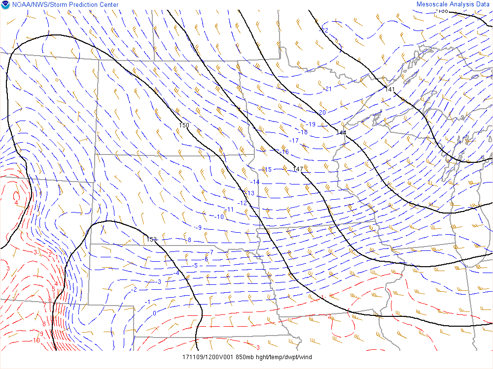
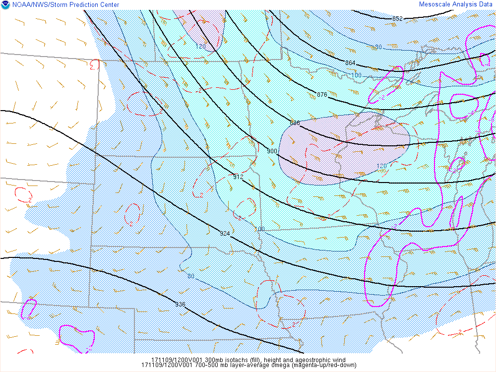
Here are a few graphics depicting the state of the atmosphere during the morning of Wednesday, Nov. 9th. The difference in the 850 mb and lake temperatures approached nearly 20 degrees Celsius, which contributed to considerable "lake-effect" instability.
 |
 |
 |
 |
|
7:00 AM EST, Nov. 9th, 2017 Mean sea level pressure (contoured) |
7:00 AM EST, Nov. 9th, 2017 850mb heights (contoured), temperatures (dashed lines), and dew point temperatures (color filled). |
7:00 AM EST, Nov. 9th, 2017 500mb heights (contoured), temperatures (dashed lines), and wind speeds (color filled). |
7:00 AM EST, Nov. 9th, 2017 300mb heights (contoured), upper-level divergence (solid pink lines), and wind speeds (color filled). |
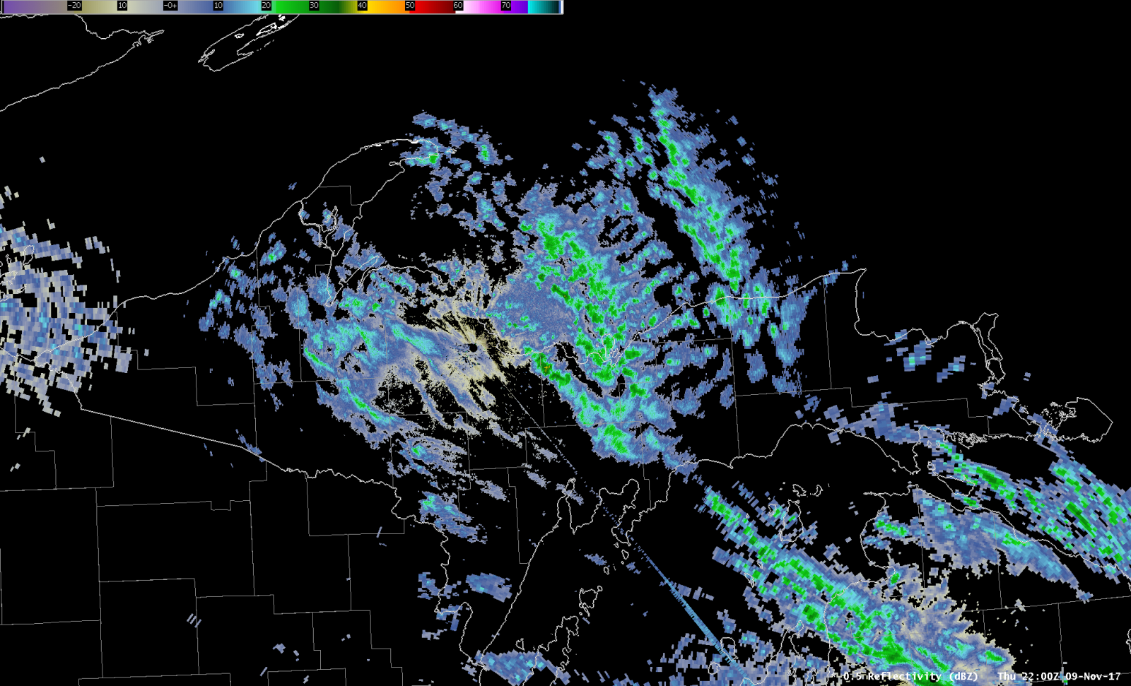
However, the instability overwhelmed the low-level shear leading to distinct convective cores (as opposed to 1-3 dominant bands). As a result, the central and eastern Lake Superior shore saw somewhat widespread but less extreme snow totals as opposed to the very high totals one may expect with dominant snow bands. However, the snow was quite intense inside each convective core, with snowfall rates approaching 1-2"/hour. As such, the heaviest snowfall totals were found where cores trained over the same area for longer periods of time.
 |
|
Regional radar image valid for 5:00 PM Nov. 8th, 2017 showing the cellular nature of the lake effect snow over the central and eastern Lake Superior shore.
|
Services:
 |
 |
 |
 |
|
6am EST: Nov. 7th, 2017 Graphic posted to our website and social media platforms highlighting the potential for significant lake effect snow and cold temperatures a few days before the event. |
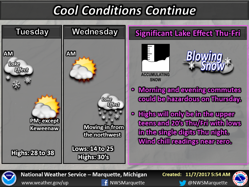
~10am EST: Nov. 7th, 2017 Additional details describing the what, when, and where of this event were provided via our website and social media platforms. This graphic highlighted the winter-like temperatures and potential snowfall amounts. |
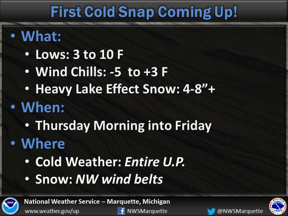
6am EST: Nov. 8th, 2017 This weather story highlighted not only the potential hazards due to the heavy lake effect snow and gusty winds, but also starting talking about snowfall totals through the event and the magnitude of the cold air. |
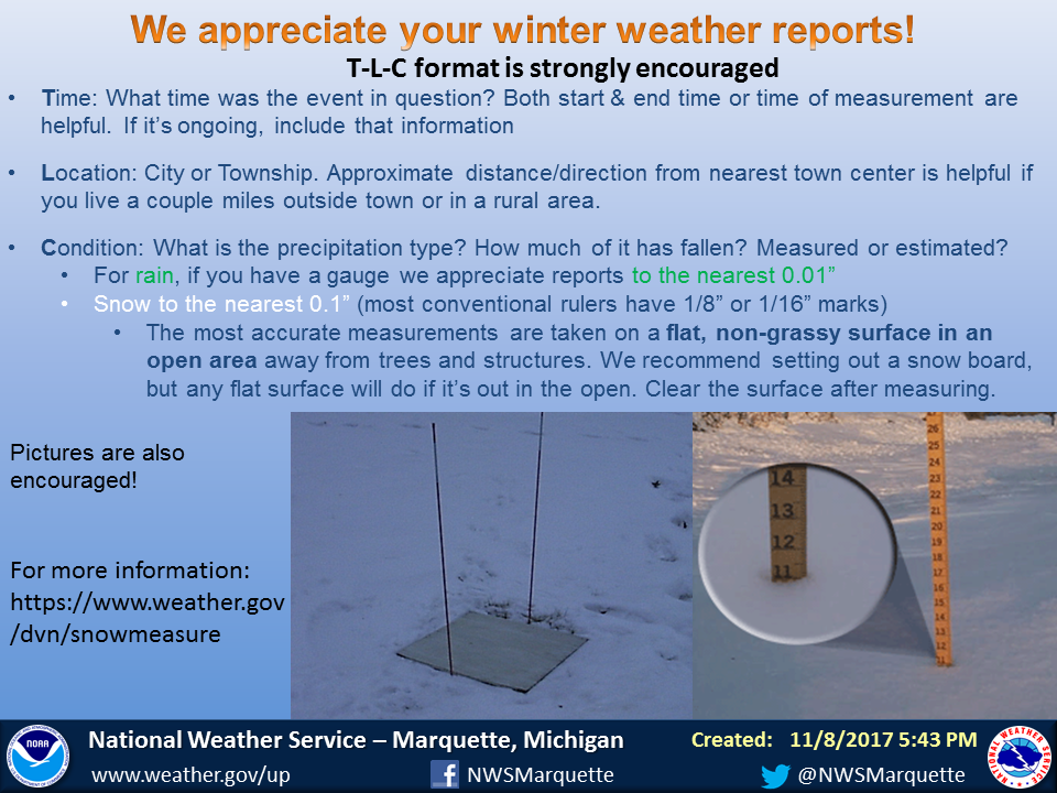
6pm EST: Nov. 8th, 2017 A graphic was posted highlighting how to measure snowfall and what information to provide within reports. |
 |
 |
|
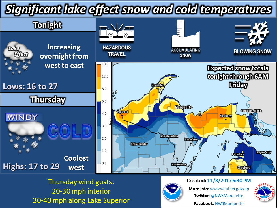
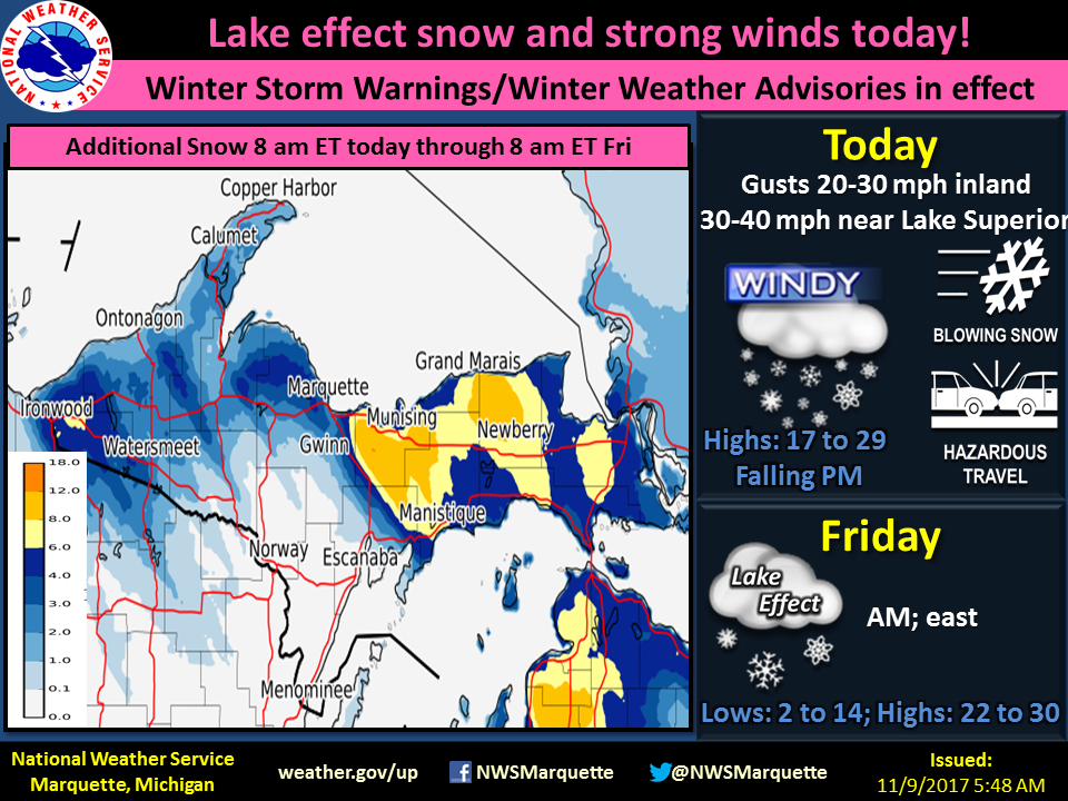
~6am EST: Nov. 9th, 2017 This graphic was shared via social media and our website during the event to provide an update on how much additional snow was expected to fall Thursday and Thursday night. |
6pm EST: Nov. 9th, 2017 This weather story highlighted the winter-like temperatures expected Thursday night, along with the continued lake effect snow near Lake Superior and the hazards associated with this snow. |
 |
Media use of NWS Web News Stories is encouraged! Please acknowledge the NWS as the source of any news information accessed from this site. |
|

