Overview
|
On Monday, December 11th, a clipper system tracked across Lake Superior and strengthened across the eastern portions of the lake bringing northerly gales to 45 knots behind the exiting system. This northerly flow allowed for moderate to heavy lake effect snow across the region through Tuesday December 12th. While numerous moderate to heavy snow bands where observed across Upper Michigan, a significant snow squall impacted the city of Marquette and areas east of M-553 late Monday through early Tuesday. Snowfall amounts affected by the band totaled between 8-12 inches.
|
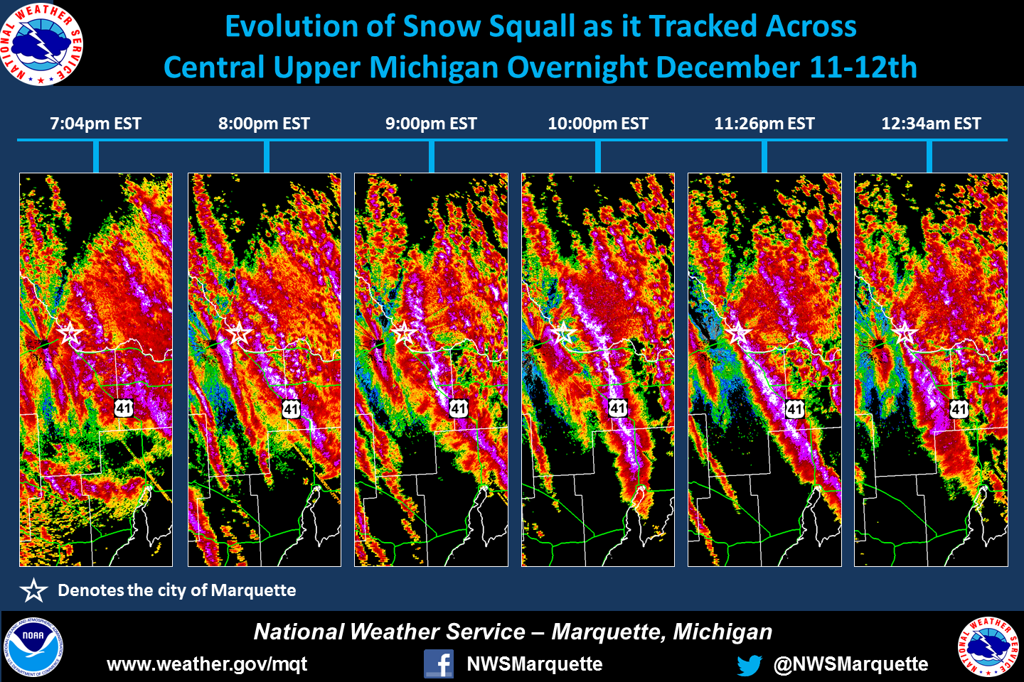 The above image shows the evolution of the snow squall that impacted eastern Marquette county and western Alger counties late Monday into early Sunday. |
Snow Reports
Here are the storm reports from the entire event. Note the wide range of reports (especially within short distances)--this is often the case with lake effect snow dominated by one or two bands.
...Snowfall Reports...

Location                     Amount    Time/Date

...Alger County...
Kiva                         11.0 in   0854 AM 12/12
Traunik                      10.0 in   0829 AM 12/12
1 W Munising                 6.0 in    0201 PM 12/12
11 S Grand Marais            5.0 in    0700 AM 12/12
Eben Junction                4.4 in    0815 AM 12/12
Wetmore 15S                  3.6 in    0800 AM 12/12
5 E Round Lake               3.6 in    0800 AM 12/12
5 ESE Forest Lake            3.1 in    0700 AM 12/12
Munising                     3.0 in    0630 AM 12/12

...Baraga County...
2 SE Herman                  3.0 in    0800 AM 12/12
1 ESE Three Lakes            2.3 in    0800 AM 12/12

...Delta County...
Rapid River                  12.0 in   0600 AM 12/12
4 S Trenary                  10.0 in   0824 AM 12/12
3 SSE Rapid River            4.1 in    0900 AM 12/12
Garden Corners               3.6 in    0800 AM 12/12
1 NW Garden Corners          3.6 in    0800 AM 12/12
Bark River                   2.0 in    0900 AM 12/12
5 NNE Stonington             2.0 in    0800 AM 12/12
9 S Rapid River              2.0 in    0800 AM 12/12
Gladstone                    1.8 in    0700 AM 12/12
4 SSW Brampton               1.5 in    0700 AM 12/12

...Gogebic County...
Ironwood                     1.4 in    0100 AM 12/12

...Houghton County...
1 E Houghton                 4.8 in    0900 AM 12/12
Kearsarge                    4.0 in    0800 AM 12/12
1 SW Allouez                 4.0 in    0800 AM 12/12
Painesdale                   3.3 in    0800 AM 12/12
2 E Redridge                 3.0 in    1100 AM 12/12
5NW Atlantic Mine            3.0 in    1100 AM 12/12
1 NE Hancock                 2.8 in    0700 AM 12/12

...Luce County...
2 SSE Newberry               6.1 in    0800 AM 12/12

...Marquette County...
Skandia                      12.0 in   0745 AM 12/12
Carlshend                    11.0 in   0808 AM 12/12
Harvey                       9.5 in    0916 AM 12/12
Marquette                    9.3 in    0100 PM 12/12
6 SSE Mountain Lake          5.6 in    1000 AM 12/12
2 SSE Harvey                 5.5 in    0625 AM 12/12
3 NE Negaunee                4.9 in    0700 AM 12/12
Green Garden                 4.4 in    0519 AM 12/12
9 SSE Big Bay                4.0 in    0700 AM 12/12
Marquette 16.0 NW            4.0 in    0700 AM 12/12
2 NW National Mine           3.0 in    0700 AM 12/12
3 W Ishpeming                3.0 in    0700 AM 12/12
4 NNW Little Lake            2.7 in    0800 AM 12/12
Clarksburg                   2.0 in    0700 AM 12/12
6 E Champion                 2.0 in    0700 AM 12/12

...Ontonagon County...
Paulding                     3.1 in    0815 AM 12/12
8 N Mass City                2.1 in    0700 AM 12/12

...Schoolcraft County...
1 S Manistique               3.0 in    0700 AM 12/12
Cooks 2NE                    2.3 in    0800 AM 12/12
2 NE Cooks                   2.3 in    0800 AM 12/12

Observations are collected from a variety of sources with varying
equipment and exposures. We thank all volunteer weather observers
for their dedication. Not all data listed are considered official.

$$
Services
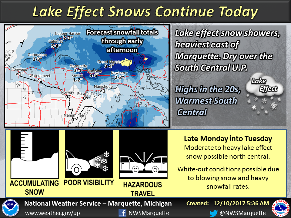
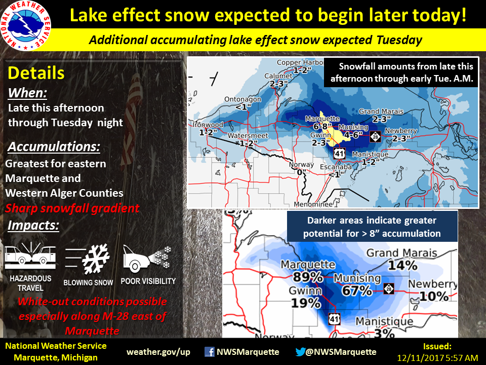
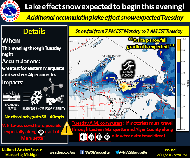
It was apparent that a lake effect snow event would take place across portions of north-central Upper Michigan days in advance. As such, graphic were sent out on social media leading up to the event focusing on eastern Marquette and western Alger counties where the heaviest snowfall was anticipated. See some of our graphics below.
 |
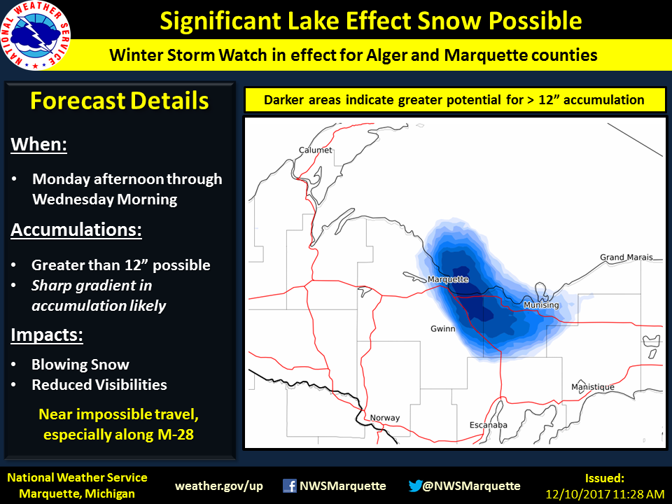 |
| Weather story issued on the morning of Sunday, December 10th highlighting the potential impacts for the expected heavy lake effect snow. | Update to the weather story on Sunday afternoon showing the area where confidence was highest that significant snow accumulations and impacts would be observed. |
 |
 |
| Weather story issued on the morning of Monday, December 11th. | Weather story update on the evening of Monday, December 11th. |
 |
 |
| Nowcast graphic showing the widespread lake effect snow bands and highlighting the impacts. | Nowcast graphic highlighting the snow squall that impacted much of eastern Marquette county and it's impacts. |
Radar Loop
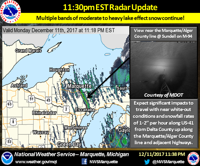
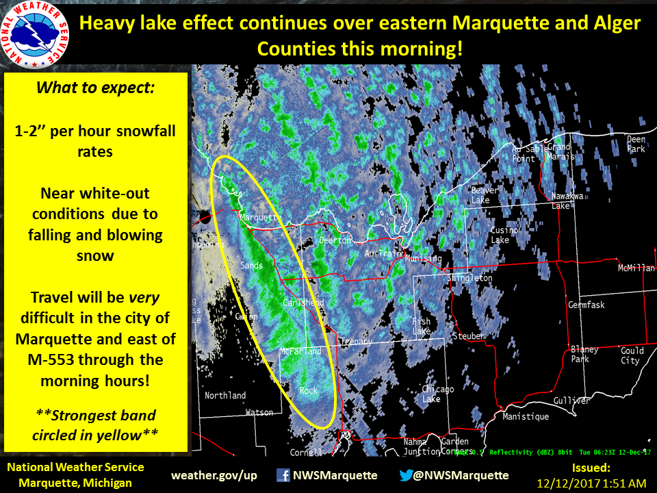
As the winds changed direction, a quickly-moving snow squall pushed through north-central Upper Michigan. Behind the initial squall, bands of lake effect snow developed across the region. As expected, a more dominant band developed overnight across eastern Marquette and western Alger counties contributing to significant short-term snowfall totals across the aforementioned areas. By morning, the dominant band weakened giving way to several bands of moderate snow. Also note how many of the bands had several distinct "cores" or cells. Such a radar presentation exemplifies the considerable lake-induced instability, resembling a similar structure to "pop-up" thunderstorms that develop on a warm summer days.
 |
| Radar loop from 5:00 PM EST Monday, 12/11 to through 7:00 AM EST Tuesday, 12/12. |
Environment
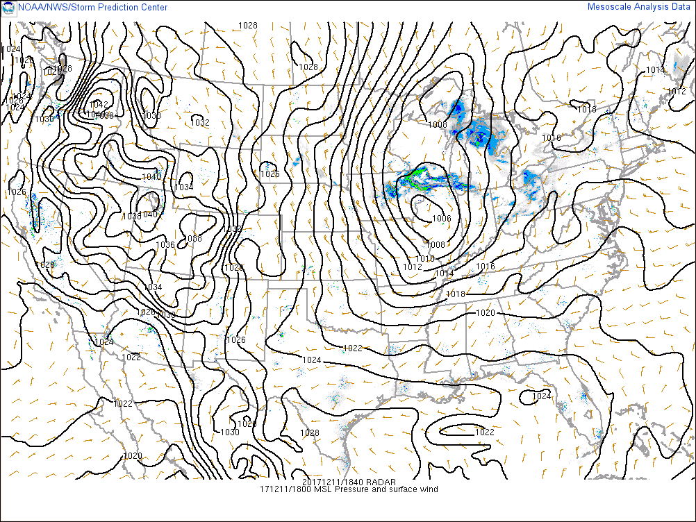
Below are upper-air and surface maps showing the progression of the synoptic setup as a clipper system tracked across the region, bringing strong cold air advection across the Upper Great Lakes as it lifted northeast. With 850 mb temperatures dropping to -15 to -25 C behind the exiting surface low, significant lake-induced CAPE developed with inversion heights approaching 8-10 thousand feet at times during the event. The track of the surface and 850 mb low allowed for quasi-unidirectional northerly flow to develop across and upstream of Lake Superior. This not only is an ideal setup for multiple snow bands to develop across the north wind snow belts, but for a dominant snow squall from an intra-lake connection. The snow squall that impacted central Upper Michigan was such a band, and had connections to Lake Nipigon up in southern Ontario, and then further down stream across Lake Michigan and lower Michigan. In fact, the strong pressure gradient as the surface and increasing cold air advection promoted strong and gusty northerly winds, which allowed the snow squall to reach all the way down to the Bay of Green Bay!
| 500 mb heights, wind speeds (color contoured), and wind barbs. | .png) |
.png) |
.png) |
.png) |
| Time and Date | 7 am EST Dec. 11th | 1 pm EST Dec. 11 | 7 pm EST Dec. 11 | 1 am EST Dec. 12 |
| 850 mb, heights, wind bards, moisture (color contoured), and temperatures (blue and red dashed lines). | .png) |
.png) |
.png) |
.png) |
| Time and Date | 7 am EST Dec. 11th | 1 pm EST Dec. 11 | 7 pm EST Dec. 11 | 1 am EST Dec. 12 |
| Mean sea level pressure, surface wind, and mosaic radar. | .png) |
 |
.png) |
.png) |
| Time and Date | 7 am EST Dec. 11th | 1 pm EST Dec. 11 | 7 pm EST Dec. 11 | 1 am EST Dec. 12 |
Below are three maps showing the low-level lapse rates between 0 and 3 km. Notice the transition to steeper low-level lapse rates over Lake Superior after cold air advection began to stream southward. This resulted in significant lake-induced CAPE and favored highly convective snow bands. At times, the lake-induced CAPE values approached 800 J/kg--which is quite impressive!
.png) |
.png) |
.png) |
| 1pm EST Dec. 11 | 7pm EST Dec 11 | 1am EST Dec 11 |
 |
Media use of NWS Web News Stories is encouraged! Please acknowledge the NWS as the source of any news information accessed from this site. |
|

