Overview
|
A strong fall storm tracked across the central Great Lakes, bringing storm force winds across Lake Superior and high winds across much of northern Upper Michigan. Frequent winds gusts of 50 to 60 mph downed thousands of trees and snapped power lines, leading to widespread power outages and hazardous travel across northern portions of Upper Michigan. Elsewhere across the region, frequent wind gusts of 30 to 40 mph resulted in sporadic power outages. As a result from the strong winds large waves were observed on Lake Superior, with the highest waves along the shoreline from Big Bay down through Grand Marais. At times, wave heights reached 25 to 30 feet. |
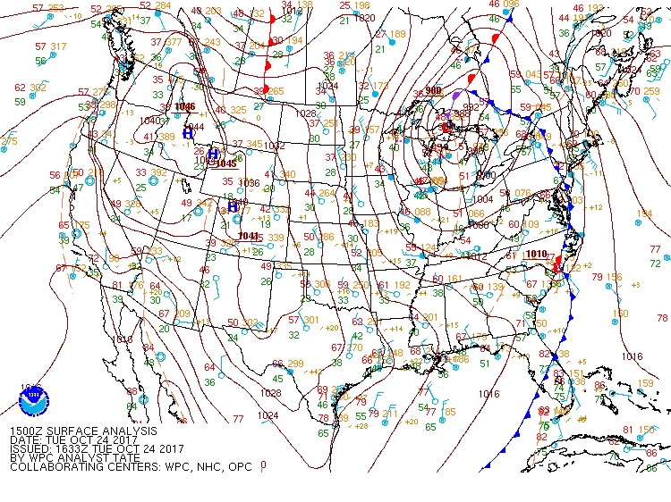 1500Z Surface Analysis showing the strong storm system tracking across eastern portions of Upper Michigan. |
 |
%20Twitter.png) |
 |
|
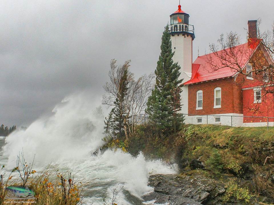
Large waves crashing into the shoreline in Eagle Harbor, Michigan. Image courtesy of @Isaac_diener |
Picture showing the extent of lakeshore flooding near Picnic Rocks in Marquette, Michigan. Image courtesy of @Nicole_TV6 |
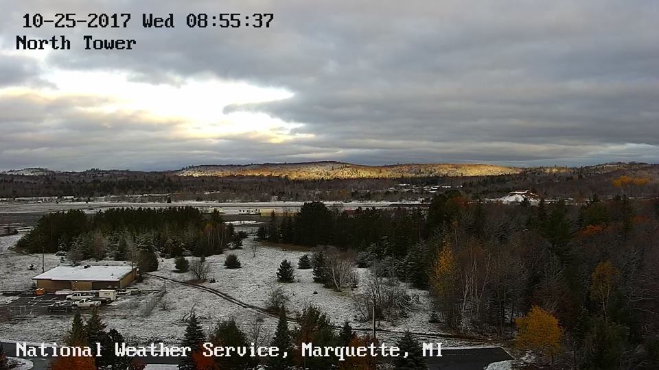
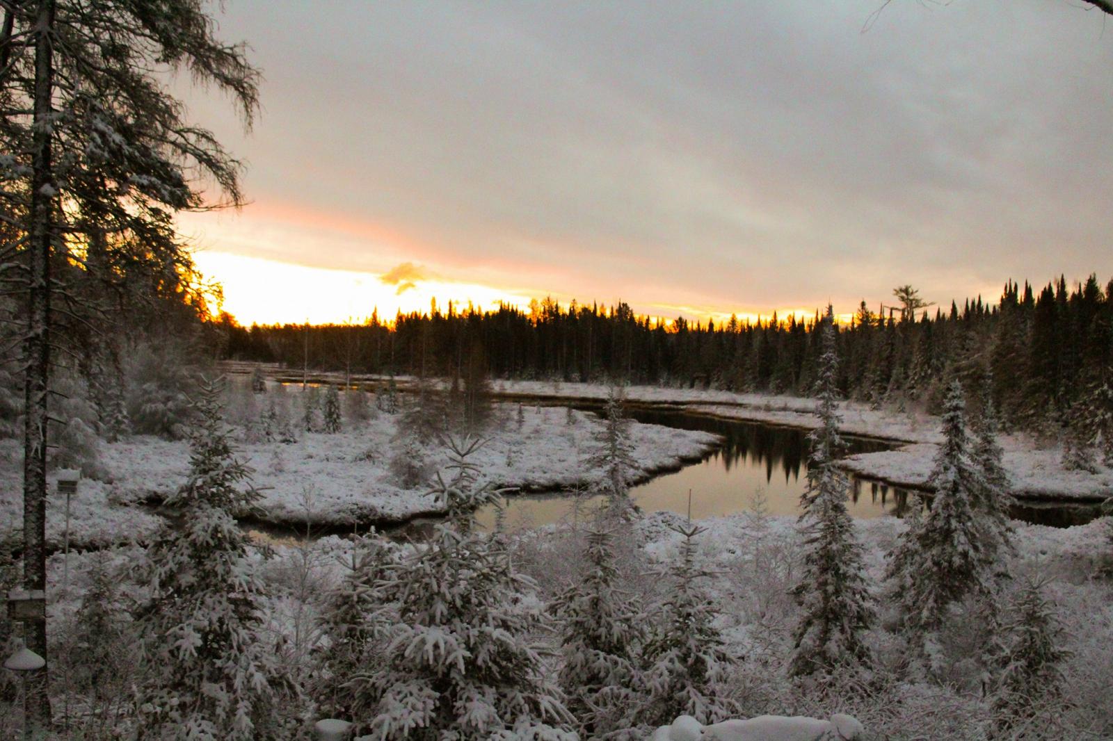
Picture of the snow that developed behind the exiting system from the NWS Marquette webcam. |
Strong Winds and High Waves:
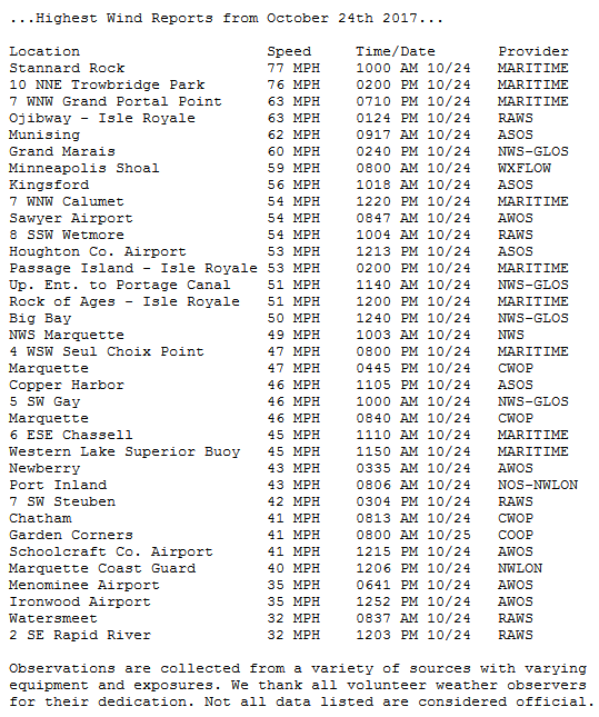
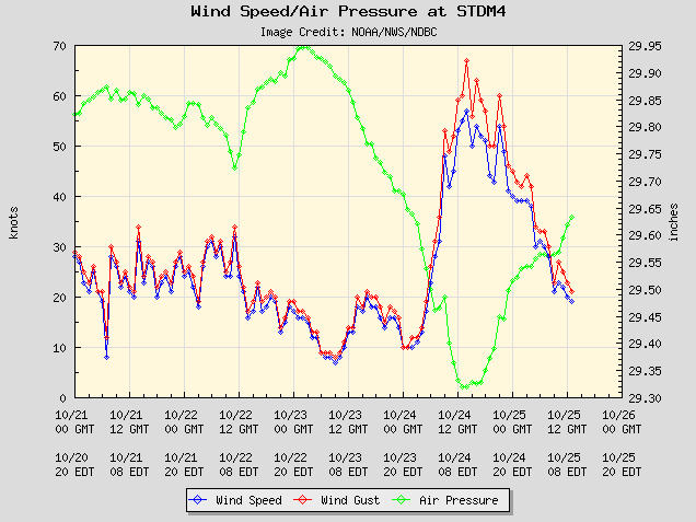
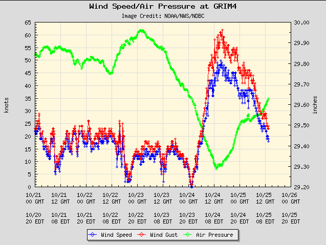
As strong northerly winds roared across central and eastern portions of Lake Superior, these strong winds impacted the open waters of Lake Superior, but also inland across north central and eastern Upper Michigan. The highest winds were recorded over the open waters of Lake Superior, with a few hurricane force wind gusts at the marine sites of Stannard Rock and Granite Island. Below is a list showing the strongest observed winds and meteograms showing the evolution of these strong winds across the open waters of Lake Superior, along with the resulting large waves.
 |
 |
 |
|
This meteogram shows the trace of pressure in green, sustained wind speeds in blue, and wind gusts in red for conditions at Stannard Rock. The highest wind gust recorded was 77 mph on the morning of Oct. 24th. |
This meteogram shows the trace of pressure in green, sustained wind speeds in blue, and wind gusts in red at Granite Island. The highest wind gust recorded was 76 mph on Oct. 24th. |
 |
 |
|
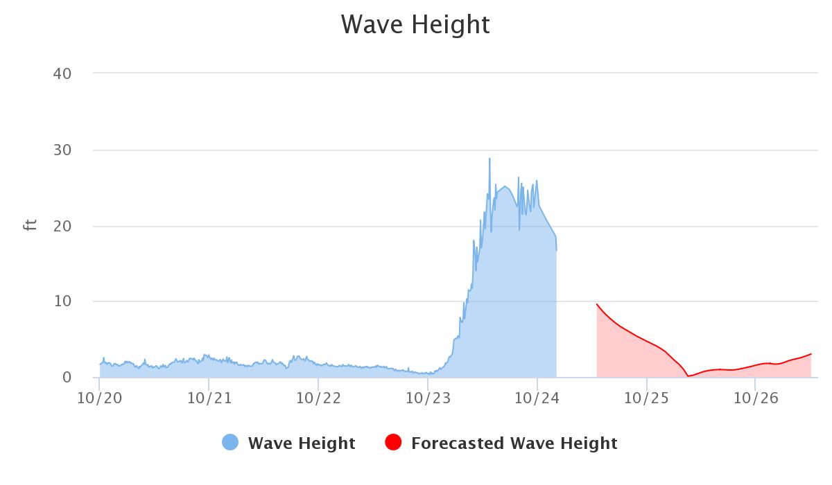
This graph shows the rapid increasing wave heights observed north of Munising just off the coast of Grand Island. Wave heights remained between 20 and 30 feet through much of the event, with the peak wave height near 30 feet. This data is courtesy of The Great Lakes Observing System and Dr. John Lenters, research scientist with Lentic Environmental Services. |
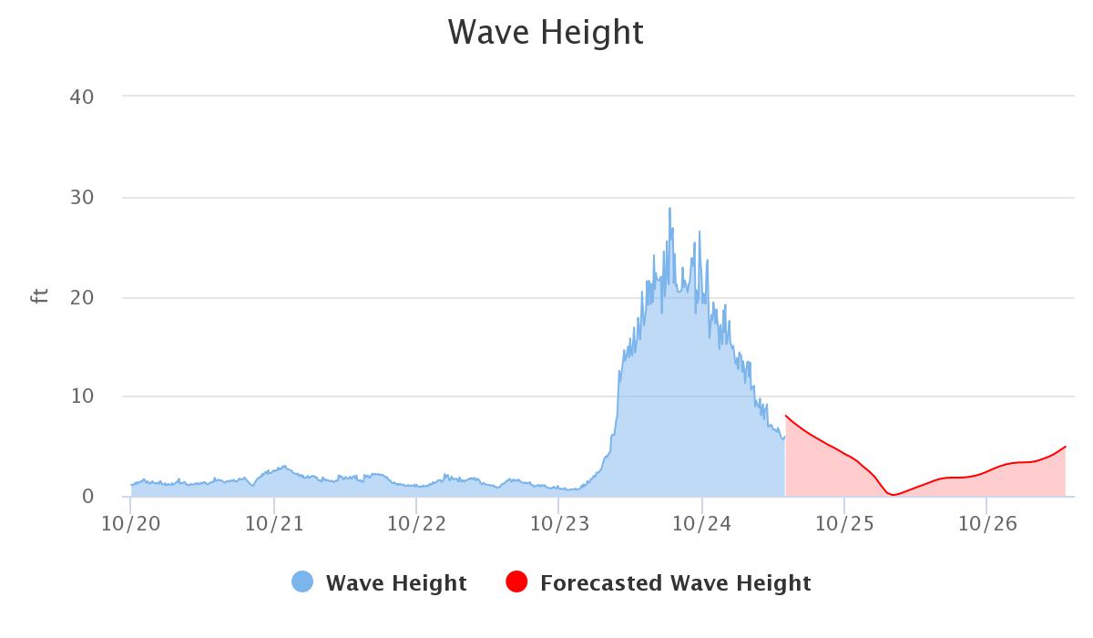
This graph shows the rapid increasing wave heights observed north of Marquette near Granite Island. Wave heights remained between 20 and 30 feet through much of the event, with a peak wave height near 30 feet. This data is courtesy of The Great Lakes Observing System and Dr. John Lenters, research scientist with Lentic Environmental Services. |
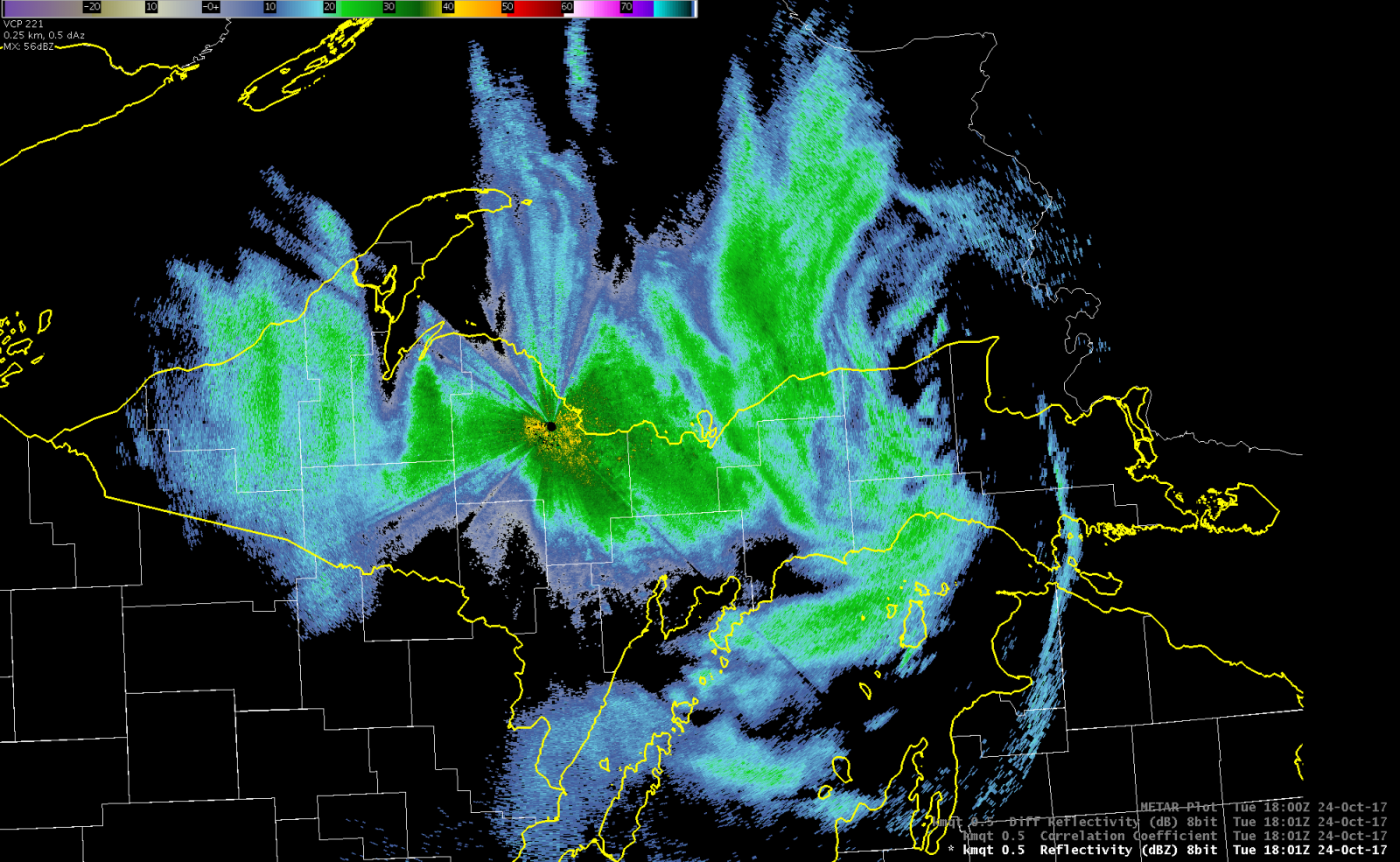
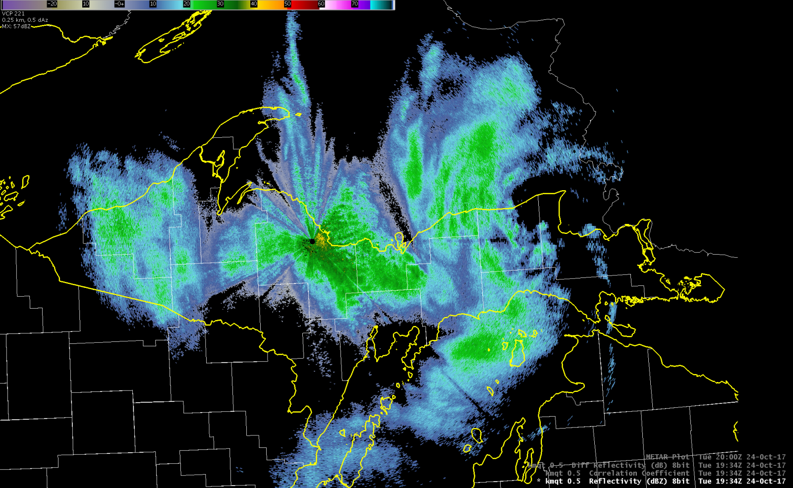
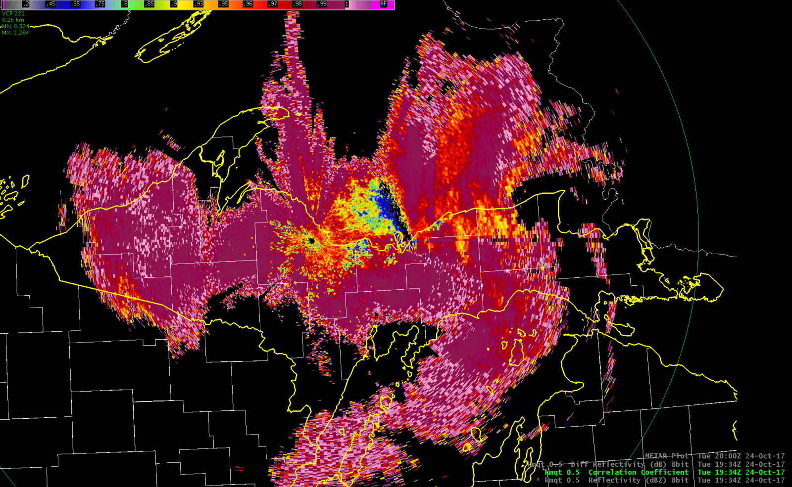
Radar:
 |
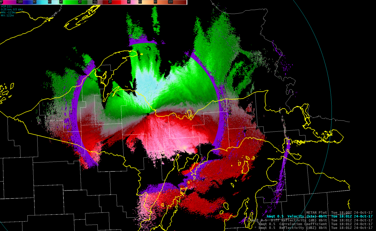 |
| Reflectivity showing fairly widespread precipitation across Upper Michigan around 2pm EDT. At the time of this radar data, light snow as falling across the western portions of Upper Michigan, rain was the predominate precipitation type across the south and east, and rain had already begun to mix in with snow across the north central. | Velocity data showing the magnitude of the strong winds aloft. These estimates reached 50 to 70 mph winds at times, but were elevated due to the curvature of the Earth; however, these stronger elevated winds were able to mix down to the surface at times, especially over Lake Superior. The bright blue to green colors show northerly winds moving towards the radar and the red to bright red colors show these northerly winds moving away from the radar. |
 |
 |
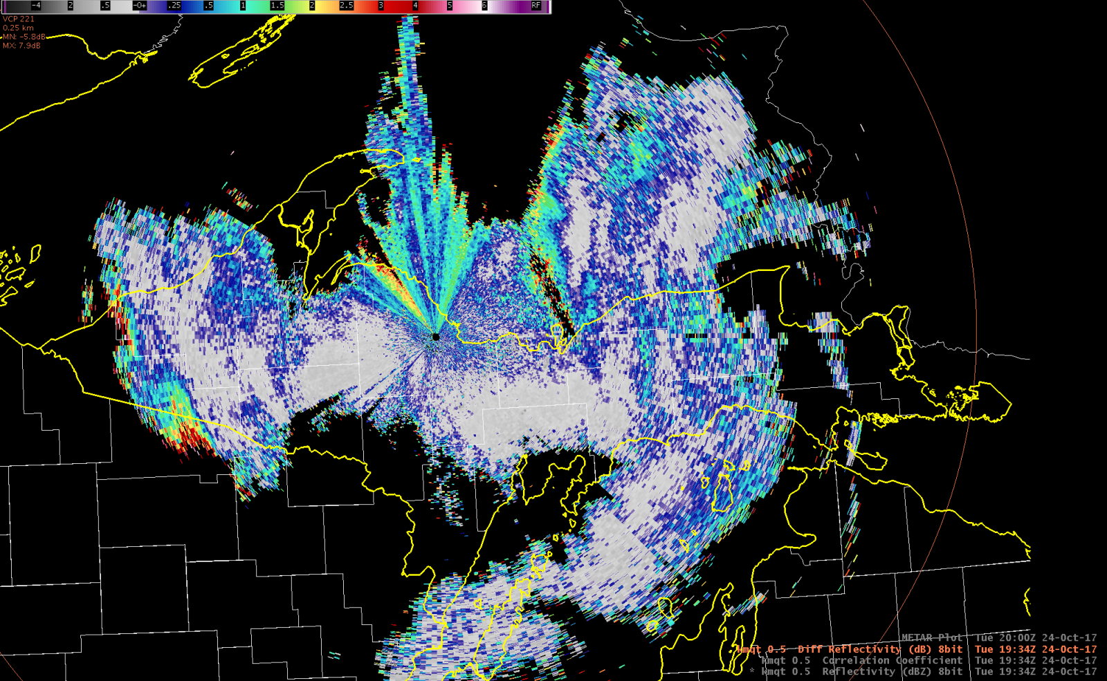 |
| Reflectivity ~3:35pm EDT showed widespread precipitation as it continued across Upper Michigan. | Correlation Coefficient (CC) ~3:35pm EDT showed a melting layer across north central portions of the area where rain began to mix with snow in some areas (shown in red, orange, and yellow colors). Elsewhere precipitation has switched over to snow across the west and remained predominately rain across the south and east (shown in purple). | Differential Reflectivity (ZDR) ~3:35pm EDT showed hints of this melting layer as well across the north central as ZDR transitioned from around or below 0 (shown primarily in the grey area across the west) to above 0 and became rather noisy. |
Storm Reports:
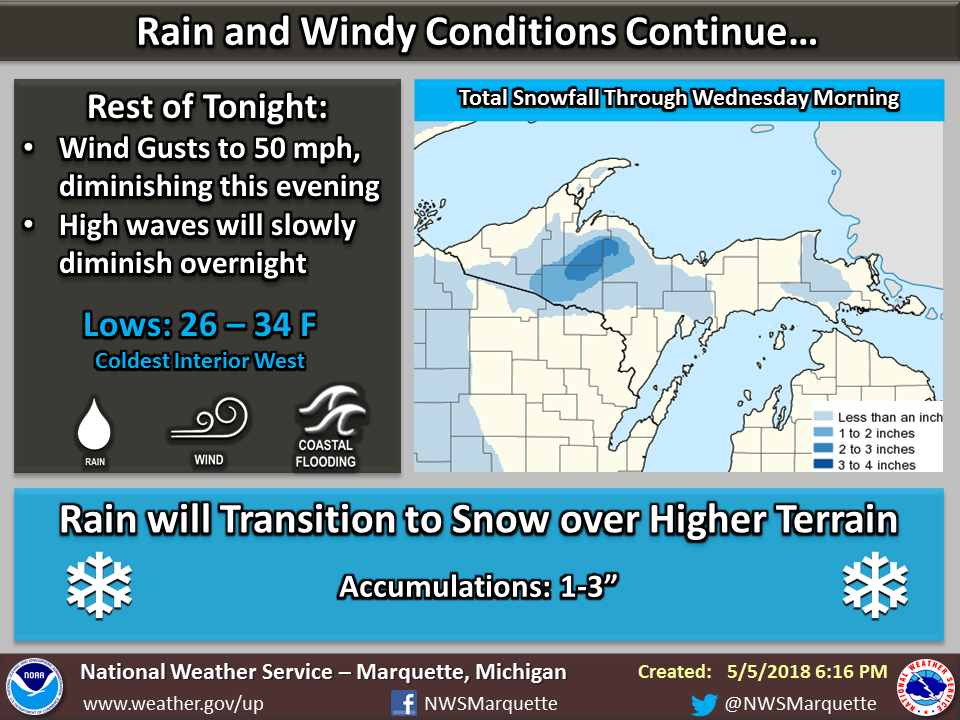
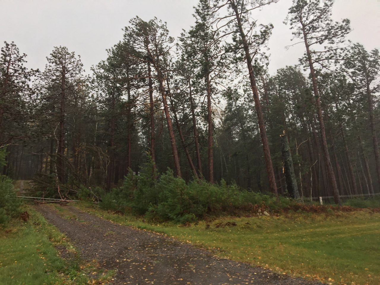
The strong winds observed across the area resulted in thousands of downed trees and power lines, mainly across the Keweenaw Peninsula and north central portions of Upper Michigan. Below is a map showing some of the reports we received of wind damage and observed wind gusts. As the main area of low pressure slowly pivoted across eastern portions of Upper Michigan, colder air began to filter across western and central portions of the area. This resulted in rain transitioning to snow. Snowfall amounts on the backside of the system ranged from just under one-half inch to upwards of 2 inches.
.png) |
| It is important to note that not all wind damage from this storm and/or snowfall amounts are represented on this map. |
Rain Reports:
| Above are the 48-hour rainfall totals across Upper Michigan. |
.png) |
| Above are a few of the higher rainfall amounts from this event. |
Meteorology/Science:
Synoptic Summary.
 |
 |
 |
 |
|
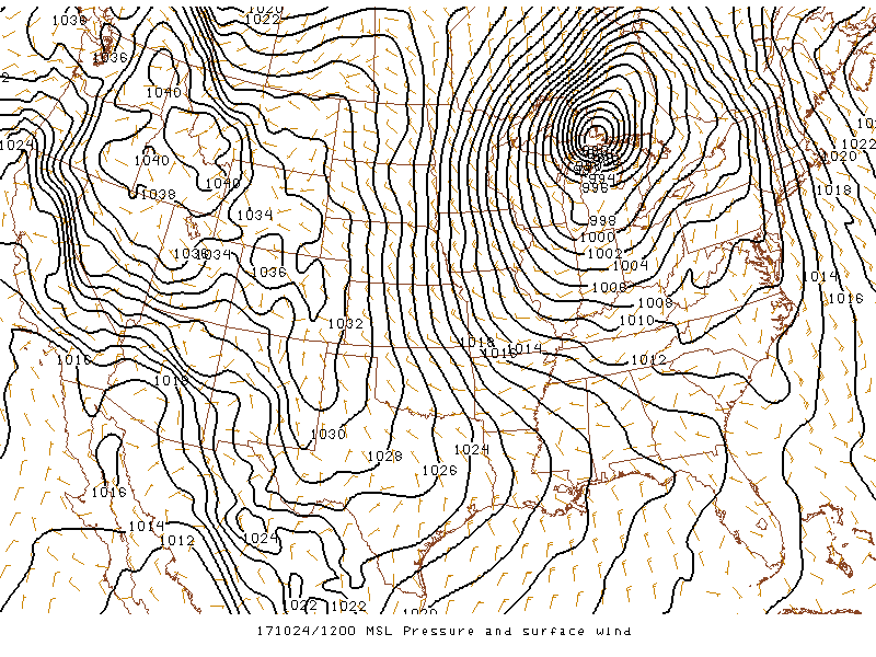
12Z Oct. 24th, 2017 Mean sea level pressure (contoured) |
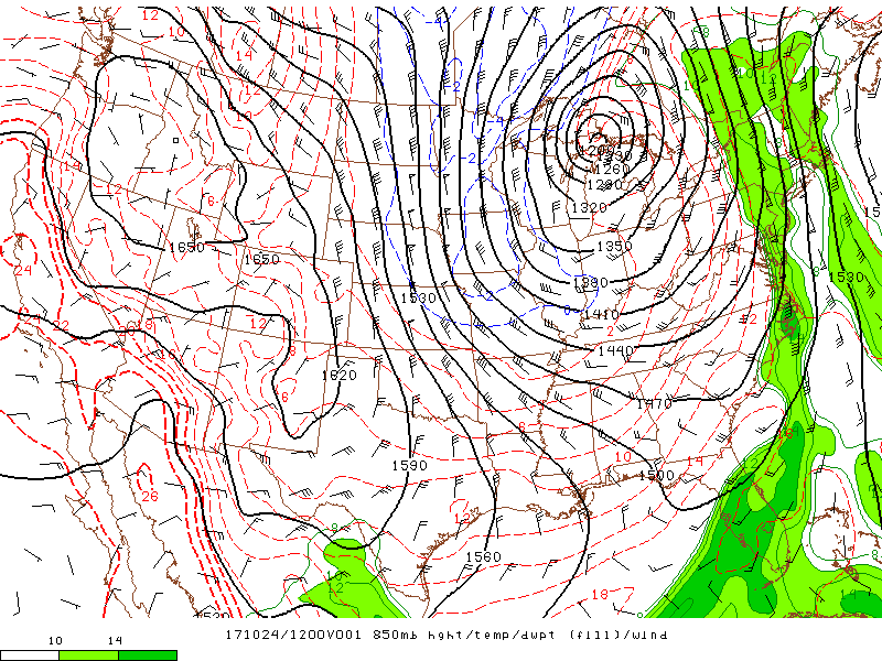
12Z Oct. 24th, 2017 850mb heights (contoured), temperatures (dashed lines), and dew point temperatures (color filled). |
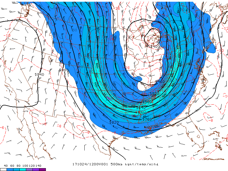
12Z Oct. 24th, 2017 500mb heights (contoured), temperatures (dashed lines), and wind speeds (color filled). |
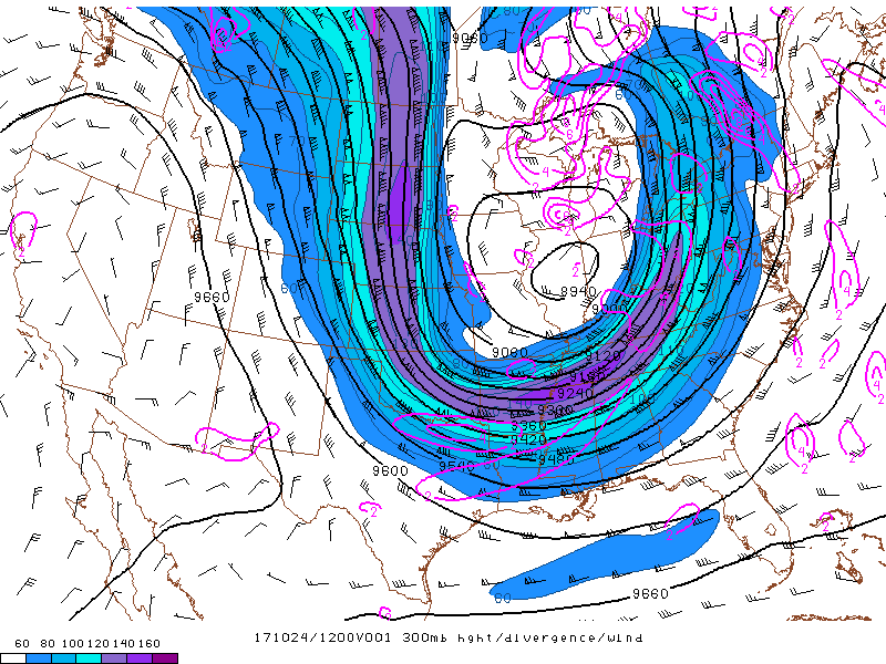
12Z Oct. 24th, 2017 300mb heights (contoured), upper-level divergence (solid pink lines), and wind speeds (color filled). |
Below is archived forecast data from the National Weather Service.
 |
 |
 |
 |
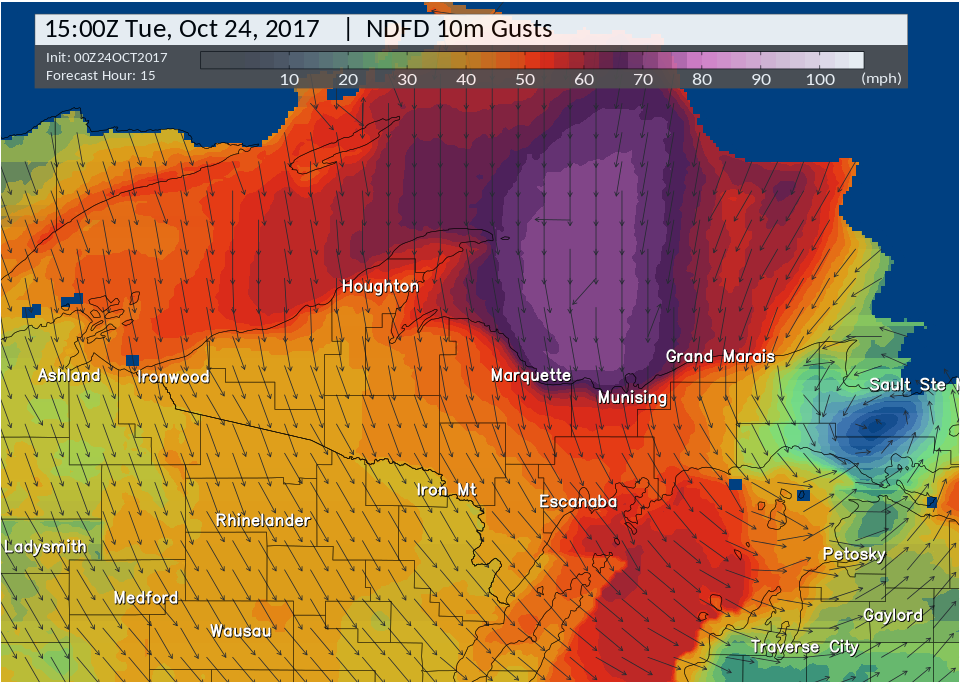
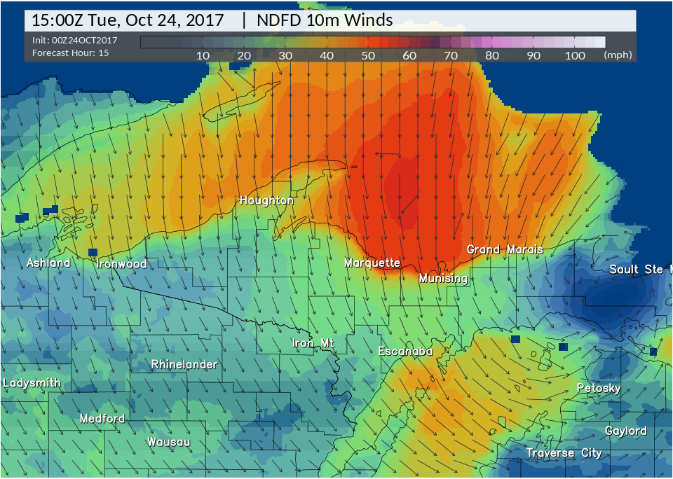
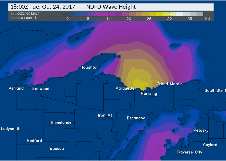
| Forecast wind gusts during the morning of October 24th, 2017. | Forecast sustained winds during the morning of October 24th, 2017. | Forecast wave heights over Lakes Superior and Michigan during the event. | Forecast snowfall behind the exiting low pressure system. |
Service Provided Before and During Event:
While the storm was quite significant, there was considerable uncertainty in the track and strength of the storm leading up to the event. The morphology of the system was quite complex--two separate low pressure systems eventually merged over eastern downstate Michigan, and the resulting low pressure system tracked northwestward toward the Upper Peninsula. While such a scenario was still uncertain early on, forecasters highlighted the potential for a strong storm as early as Thursday, October 19th in the area forecast discussion saying:
"Operational models have mostly trended away from [the trough] amplifying sufficiently to phase early on with the aforementioned energy over the [lower] Mississippi valley, which would lead to a strong storm system lifting far enough [west] into the Great Lakes region to impact the weather here significantly."
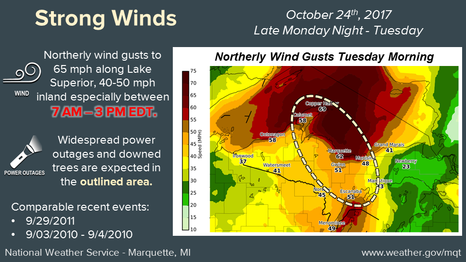
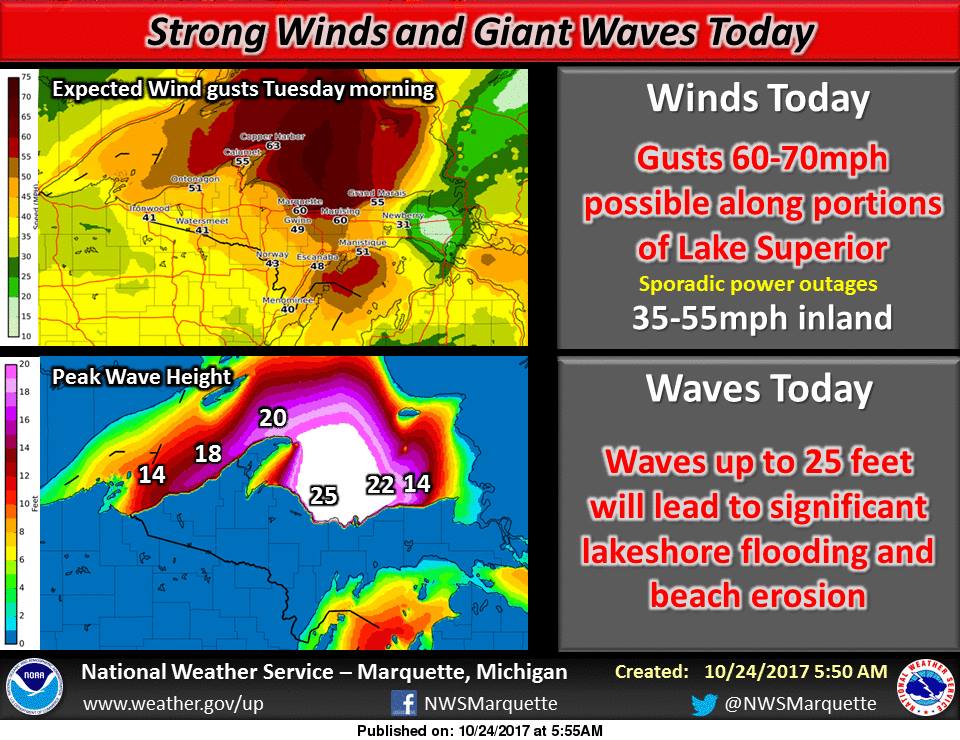
That is, even with the uncertainty in the evolution of the system, the forecaster highlighted that such a scenario would lead to significant impacts across the region. By late Sunday night, most operational models converged on the eventual strength and track of the impending storm system. As such, forecaster confidence increased considerably that the region would see very large waves and high winds. High wind and coastal flood warnings were subsequently issued just before sunrise on Monday morning as were social media graphics highlighting the impacts of the storm (see below). Additionally, forecasters started briefing both local and state wide partners about the potential impacts of the storm, providing an array of critical decision support services.
 |
 |
|
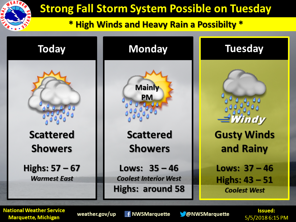
This graphic was posted during the morning of Sunday, 10/22, highlighting the potential for high winds and heavy rain on Tuesday. |
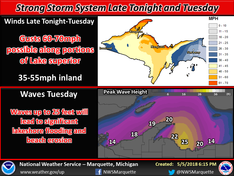
This graphic was posted during the morning of Monday, 10/23 highlighting the potential for damaging winds and very large waves. |
 |
 |
|
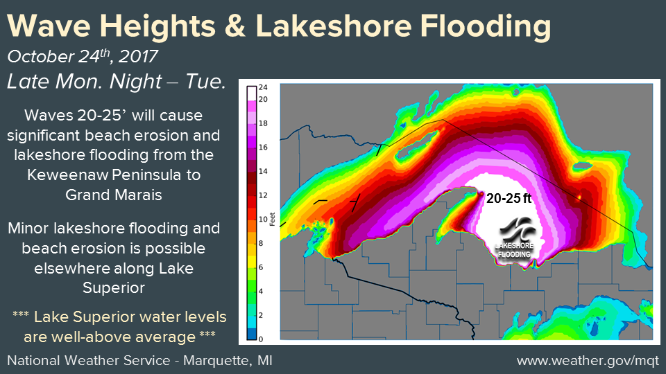
This graphic was posted during the afternoon of Monday, 10/23, highlighting the potential for very high waves and lake shore flooding. |
This graphic was posted during the afternoon of Monday, 10/23, highlighting the potential for very strong damaging winds and numerous power outages. |
 |
 |
|
This graphic was posted during the morning of the event on Tuesday, 10/24. Consistent messaging about the potentially strong damaging winds and giant waves with previous and concurrent graphics conveyed the serious nature of the threat. |
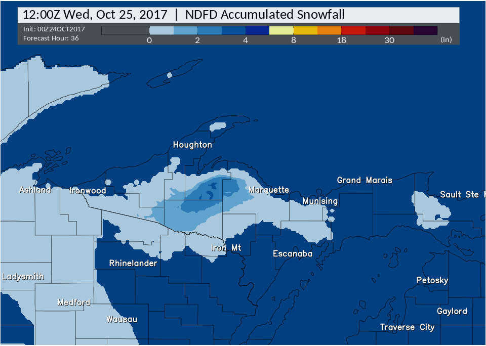
Finally, a graphic highlighting the snow potential along the backside of the system was posted during the late afternoon of Tuesday, 10/24. While snow was in the forecast well before Tuesday, forecasters decided to focus on the high wind and waves in previous graphics in order to highlight the most significant impacts of the storm. |
Photos:
 |
 |
 |
|
Large tree snapped on power line on M-28 in Marquette County. Photo taken by NWS employee. |
Several trees down along M-28 near Lakenenland. Photo taken by NWS employee |
Large tree down in Nestoria. Photo courtesy of Jill Jacobs Meadows. |
 |
 |
 |
|
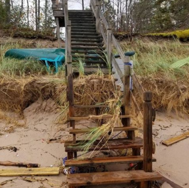
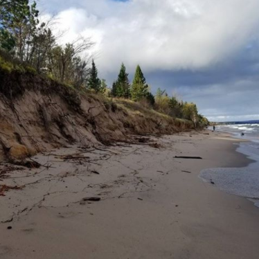
Significant beach erosion near Shot Point in Marquette County. Photo courtesy of G Marshall Bertram. |
Significant beach erosion near Shot Point in Marquette county. Photo courtesy of G Marshall Bertram. |
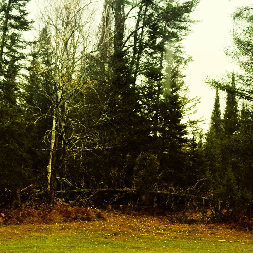
Snowfall in Nestoria. Photo courtesy of Jill Jacobs Meadows |
 |
 |
 |
|
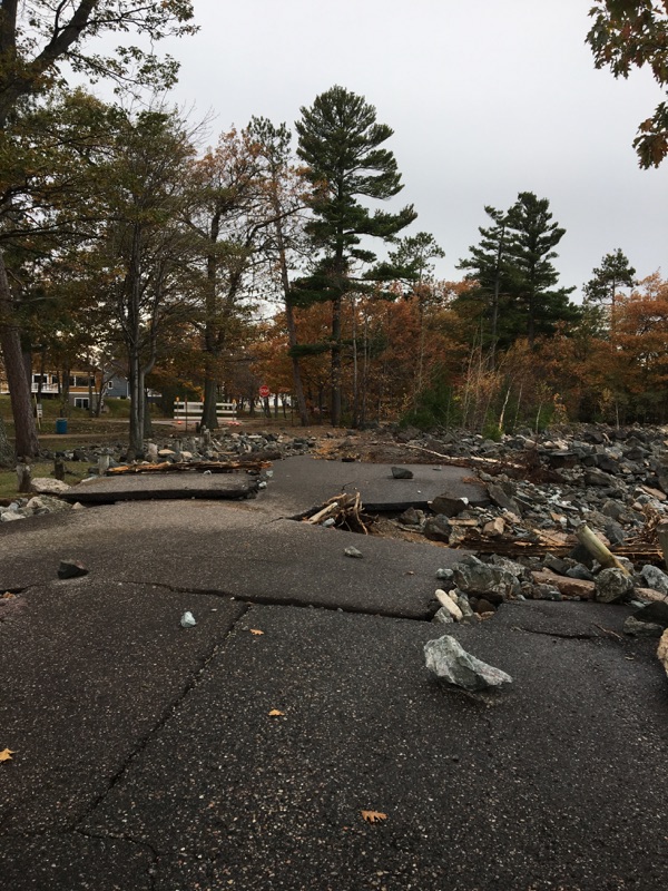
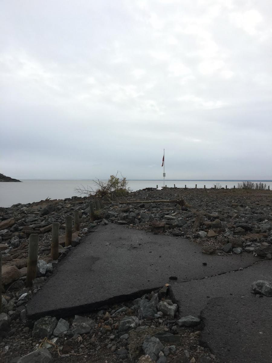
Picnic Rocks Park in Marquette. Photo taken by NWS employee. |
Picnic Rocks Park in Marquette. Photo taken by NWS employee. |
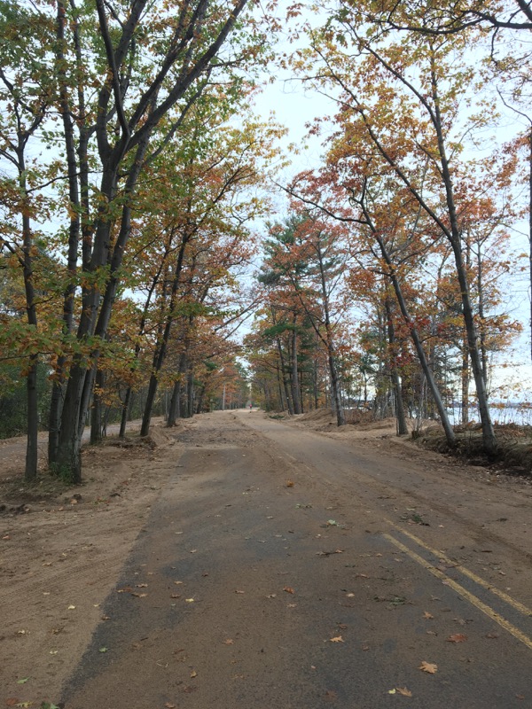
Lake Shore Boulevard in Marquette. Photo taken by NWS employee. |
 |
Media use of NWS Web News Stories is encouraged! Please acknowledge the NWS as the source of any news information accessed from this site. |
|

