Overview
|
After a stretch of relatively dry and mild conditions, a strong low pressure system impacted the Great Lakes bringing the return of winter conditions. Near-record high temperatures were met with rare December thunderstorms as the low pressure system rapidly strengthened as it approached the area. As the storm passed by, high winds with gusts over 60 MPH lead to sporadic power outages and heavy lake effect snow across the west and northwestern snow belts. A hurricane-force wind gust of 75 MPH was also measured at the Stannard Rock Lighthouse on Lake Superior. |
|
High Winds:
Gusty winds were observed across the entire Upper Peninsula on Tuesday, December 5th. The strongest winds, at times gusting over 60 MPH, were confined to Lake Superior and the western shore of Lake Superior/along the Keweenaw Peninsula. The strongest winds were reported at Stannard Rock Lighthouse, with sustained winds of 60 MPH and gusts in excess of 70 MPH. More information about winds over Lake Superior are included in the "Marine Weather" tab.
Here is a list of the highest wind reports received during the day on December 12th.
...High Wind Reports from the 12/5 to 12/6 Event...

Location                     Speed     Time/Date       Lat/Lon/Elev (ft.)

...Michigan...

...Baraga County...
1 SSE Pequaming              53 MPH    0928 AM 12/05   46.84N/88.38W
1 WNW Michigamme             52 MPH    0147 AM 12/05   46.54N/88.13W

...Delta County...
3 N Escanaba                 44 MPH    0447 AM 12/05   45.79N/87.08W
Rapid River                  43 MPH    0719 AM 12/05   45.93N/86.98W
7 SW Steuben                 43 MPH    0504 AM 12/05   46.13N/86.58W
2 ENE Ford River             41 MPH    0425 AM 12/05   45.69N/87.11W

...Dickinson County...
Kingsford                    44 MPH    0716 AM 12/05   45.82N/88.11W

...Gogebic County...
Wakefield                    49 MPH    0533 AM 12/05   46.48N/89.95W
Ironwood Airport             43 MPH    1203 PM 12/05   46.53N/90.13W

...Houghton County...
1 WSW Twin Lakes             62 MPH    0647 AM 12/05   46.88N/88.86W
Houghton Co. Airport         61 MPH    0555 PM 12/05   47.17N/88.49W
Up. Ent. to Portage Canal    54 MPH    0940 AM 12/05   47.28N/88.53W
1 SW Laurium                 52 MPH    0647 PM 12/05   47.22N/88.46W
4 NNW Hancock                49 MPH    0115 PM 12/05   47.19N/88.63W
1 E Trout Creek              48 MPH    0648 AM 12/05   46.48N/88.99W
Jacobsville                  44 MPH    0700 AM 12/06   47.01N/88.43W
5 SW Gay                     41 MPH    0200 PM 12/05   47.18N/88.24W

...Keweenaw County...
4 S Copper Harbor            46 MPH    0400 PM 12/05   47.40N/87.90W
Copper Harbor                45 MPH    0713 PM 12/05   47.47N/87.88W

...Luce County...
Newberry                     54 MPH    0534 AM 12/05   46.31N/85.46W

...Marquette County...
1 E Gwinn                    43 MPH    0717 PM 12/05   46.28N/87.42W
3 NE Negaunee                41 MPH    0641 PM 12/05   46.53N/87.55W
Marquette Coast Guard        40 MPH    0806 AM 12/05   46.55N/87.38W

...Menominee County...
Menominee Airport            41 MPH    0341 AM 12/05   45.13N/87.64W

...Ontonagon County...
Ontonagon                    59 MPH    0908 AM 12/05   46.89N/89.32W
6 E Mass City                40 MPH    0547 PM 12/05   46.77N/88.95W

...Schoolcraft County...
Port Inland                  53 MPH    0712 AM 12/05   45.97N/85.87W
Cooks                        41 MPH    0717 AM 12/05   45.91N/86.48W
1 SW Germfask                40 MPH    0603 AM 12/05   46.24N/85.94W

...Maritime Stations...
Stannard Rock                75 MPH    0700 PM 12/05   47.18N/87.22W
Passage Island - Isle Royale 60 MPH    0900 AM 12/05   48.22N/88.37W
Ojibway - Isle Royale        56 MPH    0824 AM 12/05   48.11N/88.61W
Rock of Ages - Isle Royale   53 MPH    0800 AM 12/05   47.87N/89.31W
Minneapolis Shoal            49 MPH    0705 AM 12/05   45.58N/87.00W
Grand Marais                 47 MPH    0840 PM 12/05   46.68N/85.98W

Observations are collected from a variety of sources with varying
equipment and exposures. We thank all volunteer weather observers
for their dedication. Not all data listed are considered official.

$$
Marine Weather:
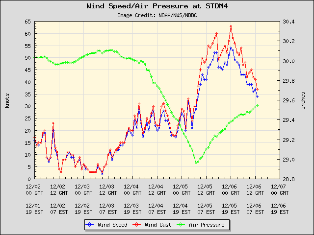
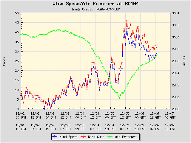
The highest winds for this event were measured on Lake Superior at the Stannard Rock Lighthouse. The station reported wind gusts in excess of 60 MPH from ~4:30 AM 12/5 to 3:00 AM 12/6--over 22 hours straight! At times, the wind was sustained at 60 mph with gusts in excess of 70 MPH! The peak gust at Stannard Rock Lighthouse was 75 MPH at ~ 7:00 PM 12/5.
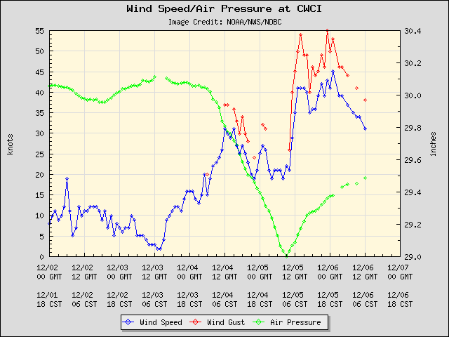
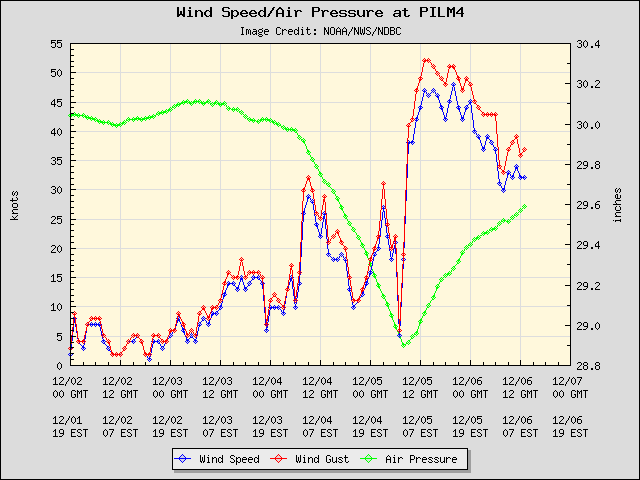
Below are plots of the wind speed (knots, blue), wind gusts (knots, red), and air pressure (inches of mercury, green) courtesy of the National Data Buoy Center.
 |
 |
|
Stannard Rock (Click on the image for larger version) |
Caribou Island (Canada) (Click on the image for larger version) |
 |
 |
|
Passage Island - Isle Royale (Click on the image for larger version) |
Rock of Ages - Isle Royale (Click on the image for larger version) |
Snowfall Reports:
While some snow fell along the backside of the system, the majority of the snow from this event will fall as lake effect. As of now, here are the highest wind reports we've received.
...36-hour Snowfall Reports...

* Last Updated at 9:00 AM EST 12/6*

Location                     Amount    Time/Date       Lat/Lon

...Michigan...

...Baraga County...
Keweenaw Bay                 7.5 in    0500 AM 12/06   46.86N/88.48W
Three Lakes                  1.0 in    0800 AM 12/06   46.56N/88.21W

...Dickinson County...
Norway                       0.2 in    0800 AM 12/06   45.78N/87.90W

...Gogebic County...
2 NW Ironwood                6.2 in    0800 AM 12/05   46.47N/90.18W
Bessemer                     4.0 in    0500 AM 12/05   46.48N/90.05W
12 WSW Watersmeet            0.5 in    0700 AM 12/05   46.22N/89.41W

...Houghton County...
Painesdale                   11.8 in   0800 AM 12/06   47.03N/88.67W
1 N Hancock                  10.0 in   1000 AM 12/05   47.14N/88.60W
Kearsarge                    9.0 in    0800 AM 12/05   47.28N/88.42W
1 ENE Hancock                7.5 in    0700 AM 12/06   47.14N/88.58W
Jacobsville                  7.4 in    0700 AM 12/06   47.01N/88.43W
Chassell                     7.0 in    0800 AM 12/06   47.03N/88.53W
2 E South Range              2.7 in    0800 AM 12/05   47.08N/88.60W
1 E Houghton                 1.0 in    1015 AM 12/05   47.11N/88.53W
1 SW Allouez                 1.0 in    0800 AM 12/05   47.28N/88.42W
Jacobsville                  0.6 in    0700 AM 12/05   47.01N/88.43W

...Marquette County...
Clarksburg                   0.6 in    0700 AM 12/06   46.50N/87.84W
NWS Marquette                0.3 in    1200 AM 12/06   46.53N/87.55W
Big Bay 9SW                  0.3 in    0800 AM 12/05   46.75N/87.88W
2 NW National Mine           0.2 in    0700 AM 12/05   46.49N/87.72W
Clarksburg                   0.1 in    0700 AM 12/05   46.50N/87.84W
Marquette 16.0 NW            0.1 in    0700 AM 12/05   46.71N/87.64W

...Ontonagon County...
Ontonagon                    8.0 in    0900 PM 12/05   46.87N/89.31W
Bergland Dam                 4.2 in    0800 AM 12/05   46.59N/89.55W
Paulding                     0.7 in    0800 AM 12/06   46.40N/89.18W

Observations are collected from a variety of sources with varying
equipment and exposures. We thank all volunteer weather observers
for their dedication. Not all data listed are considered official.

$$
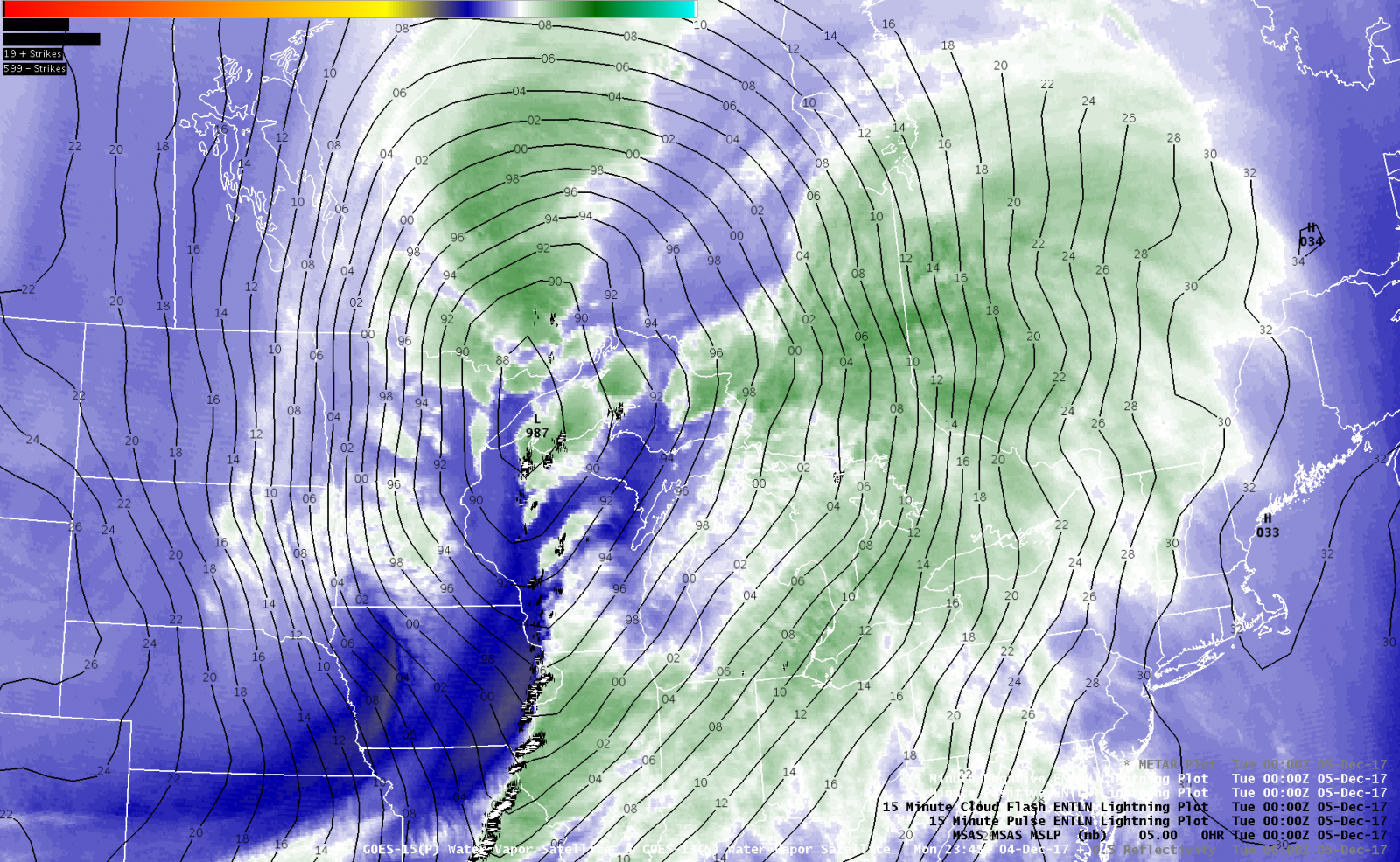
Meteorology:
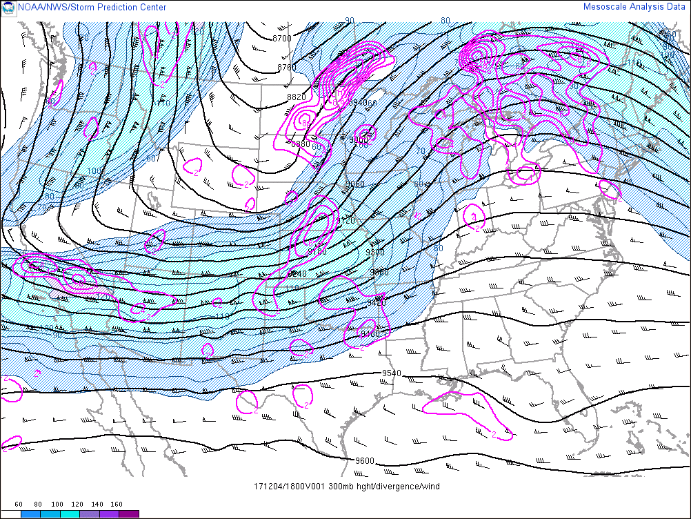
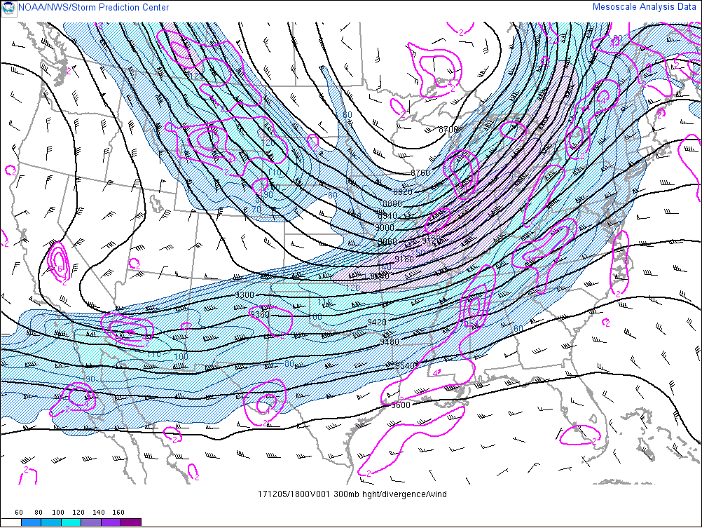
The maps below from the surface through 300 mb (~ 30,000 ft) demonstrate the evolution of the strong and dynamic storm that tracked across western Lake Superior late Monday, Dec. 4th through Tuesday Dec. 5th.
As can be seen in the following three maps at 300 mb (~ 30,000 ft), two upper-level jet streaks (shaded) "coupled" or phased enabling large-scale diffluence (magenta coutours) over the northern Plains. The upper-level trough adopted a strongly-negative tilt as it progressed into the Ohio River Valley, fostering the rapid deepening of the surface low pressure system.
 |
 |
 |
|
1:00 PM EST, Dec. 4th, 2017 300mb heights, wind speeds, and divergence |
1:00 AM EST, Dec. 5th, 2017 300mb heights, wind speeds, and divergence |
1:00 PM EST, Dec. 5th, 2017 300mb heights, wind speeds, and divergence |
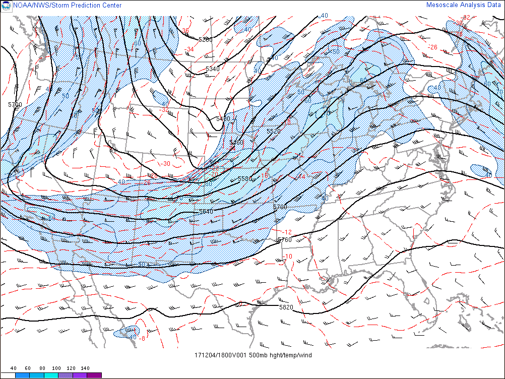
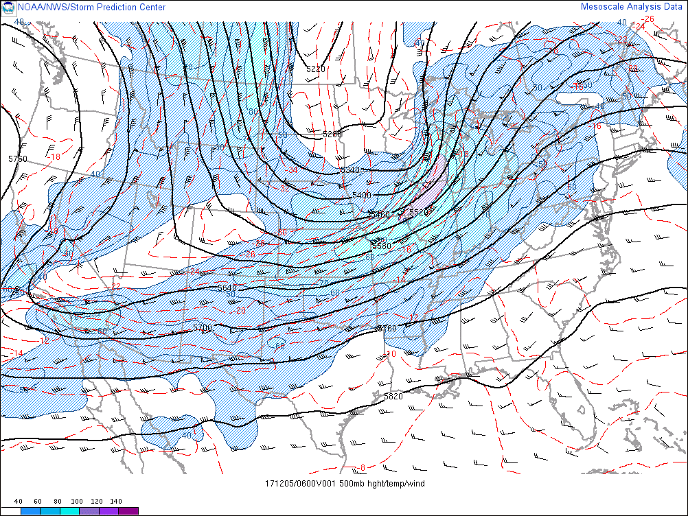
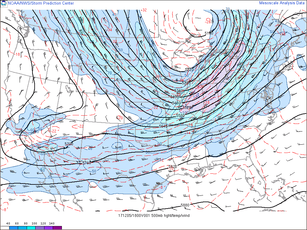
A similar evolution was evident at 500 mb, or roughly 18,000 feet into the atmosphere. Note the strong 120 knot jet streak over the central Great Lakes.
 |
 |
 |
|
1:00 PM EST, Dec. 4th, 2017 500mb heights, temperatures, and wind speeds |
1:00 AM EST, Dec. 5th, 2017 500mb heights, temperatures, and wind speeds |
1:00 PM EST, Dec. 5th, 2017 500mb heights, temperatures, and wind speeds |
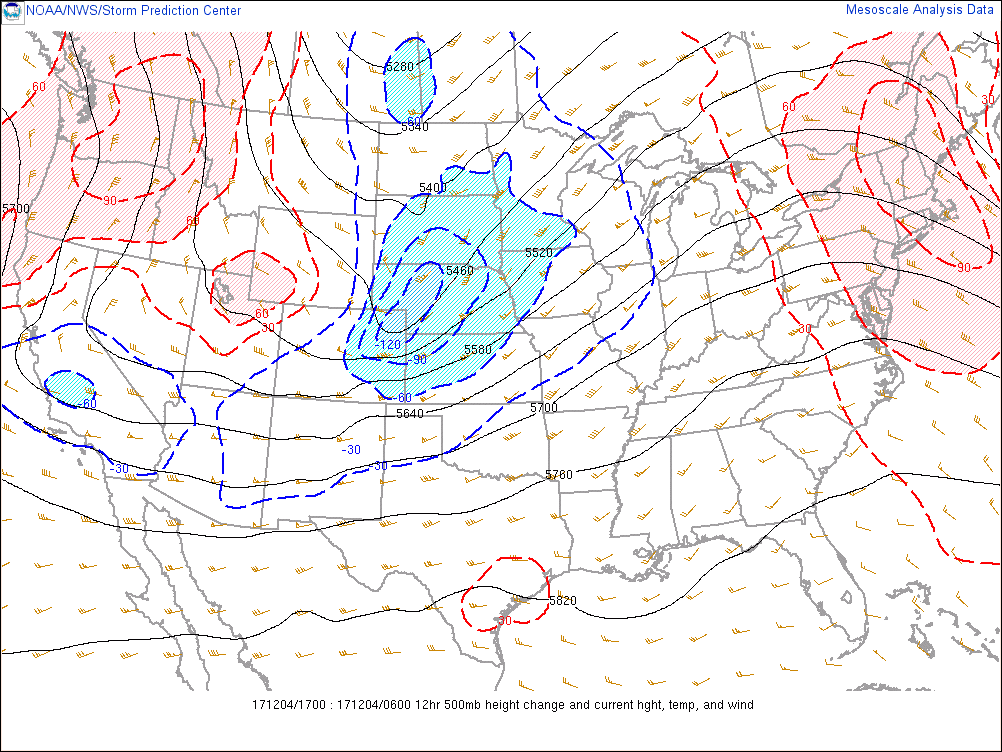
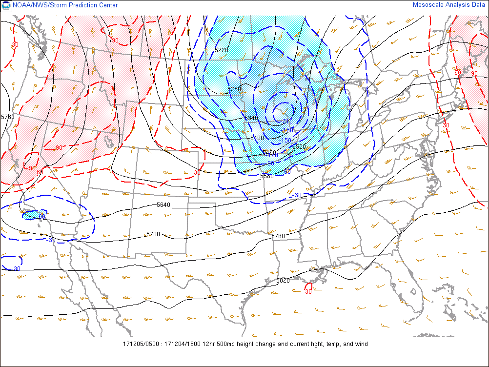
The rapid strengthening of the storm is easily visible by examining the 500 mb height falls, which are related to changes in pressure. Notice how the height falls increased significantly with time, hinting at the rapid strengthening of the storm.
 |
 |
 |
|
1:00 PM EST, Dec. 4th, 2017 500mb heights and 12-hour height changes |
1:00 AM EST, Dec. 5th, 2017 500mb heights and 12-hour height changes |
1:00 PM EST, Dec. 5th, 2017 500mb heights and 12-hour height changes
|
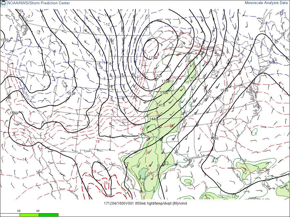
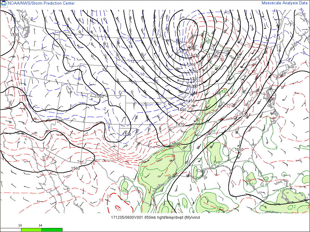
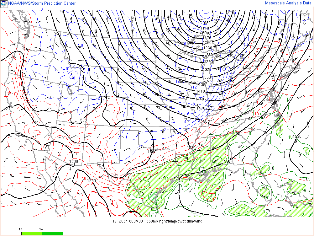
Closer to the ground (~ 5000 ft), strong warm air advection ahead of the surface low contributed to unseasonable warm temperatures on December 4th as well as rare December thunderstorms. With relatively low freezing levels, some thunderstorms produced quite a bit of lightning and even small hail. Also note the strong cold air advection, which factored into the strong winds at the surface.
 |
 |
 |
|
1:00 PM EST, Dec. 4th, 2017 850mb heights, temperatures, wind speeds, and moisture |
1:00 AM EST, Dec. 5th, 2017 850mb heights, temperatures, wind speeds, and moisture |
1:00 PM EST, Dec. 5th, 2017 850mb heights, temperatures, wind speeds, and moisture |
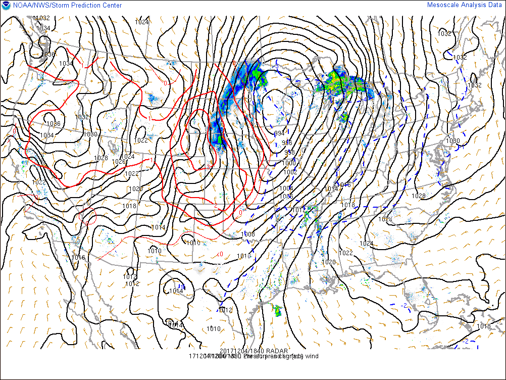
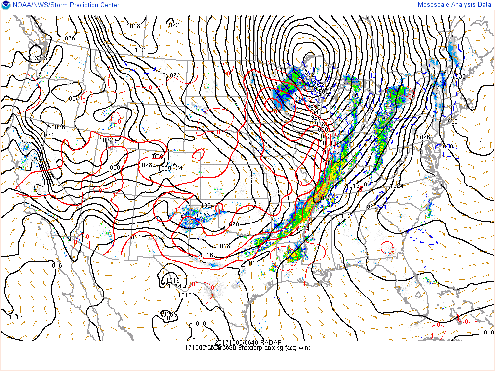
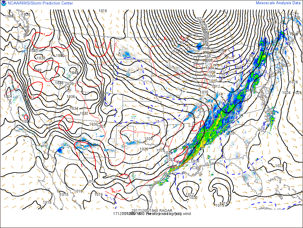
At the surface, the rapid deepening of the low pressure system was evident, dropping over 20 mb in a 24 hour period. Also notice how the surface pressure tendency couplet strengthened with time (e.g. red and blue lines). The very strong winds observed on and along the western shore of Lake Superior were enhanced by this pressure tendency couplet, which is known as the isallobaric wind. As the system moved over Lake Superior, rain quickly changed to snow from west to east. Combined with strong westerly winds, many locations along the Keweenaw Peninsula saw blizzard-like conditions.
 |
 |
 |
|
1:00 PM EST, Dec. 4th, 2017 Mean sea level pressure, 2-hr pressure changes, and mosaic reflectivity |
1:00 AM EST, Dec. 5th, 2017 Mean sea level pressure, 2-hr pressure changes, and mosaic reflectivity |
1:00 PM EST, Dec. 5th, 2017 Mean sea level pressure, 2-hr pressure changes, and mosaic reflectivity |
Service Provided:
 |
 |
|
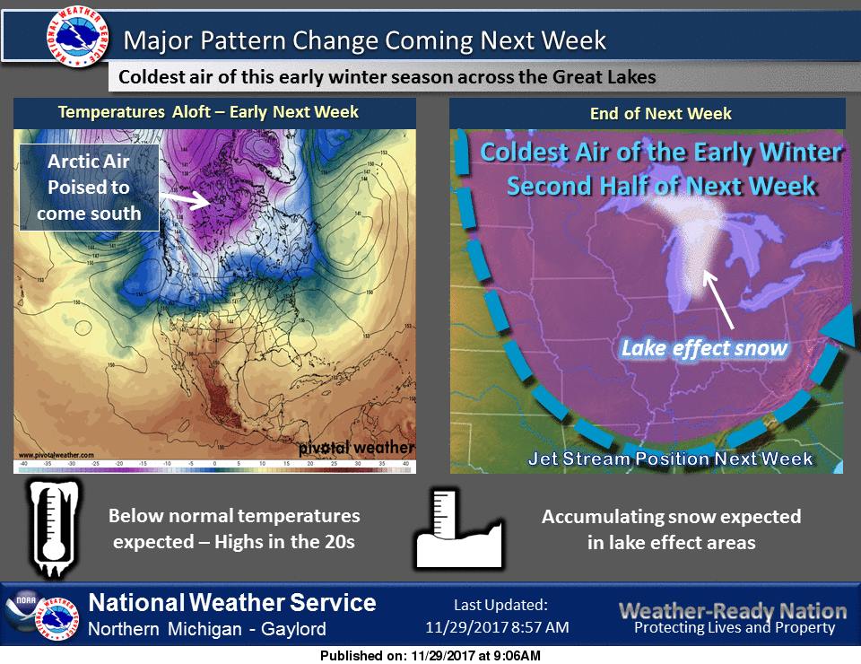
9:30 AM EST, Nov. 29th, 2017 We first indicated the potential for a pattern change on November 29th by sharing a graphic made by our friends at the NWS office in Gaylord. |
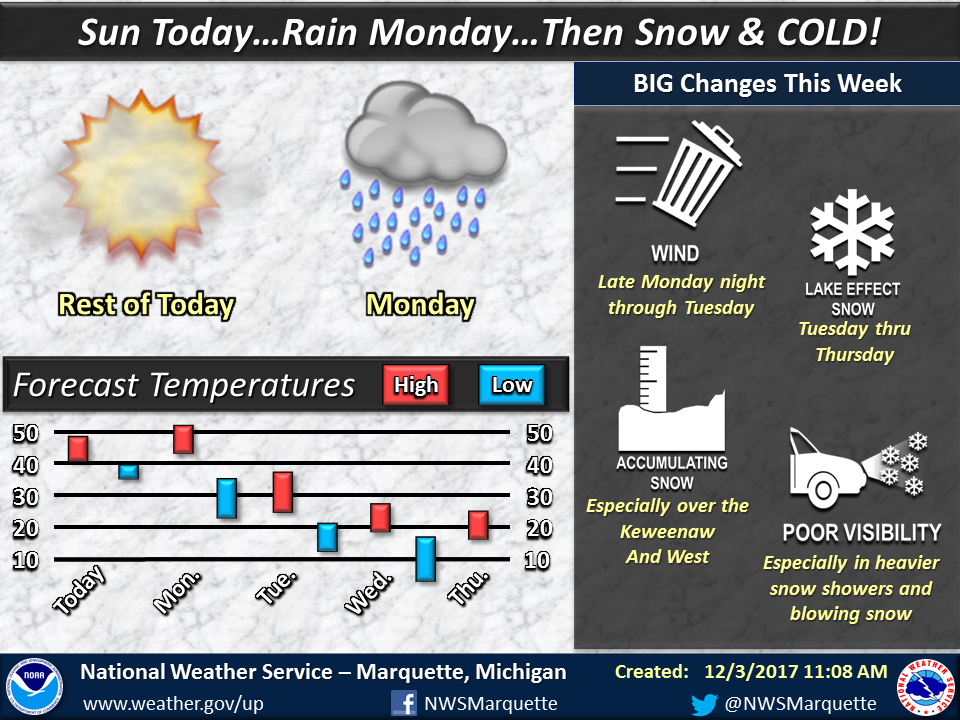
~11:15 am EST, Dec. 3rd, 2017 Soon after, we started highlighting the potential for gusty winds and lake effect snow. The details of the storm were still uncertain owing to model spread in system track and intensity. |
 |
 |
|
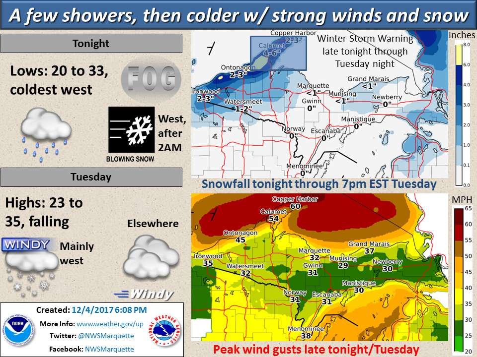
~6:00 PM EST, Dec. 4th, 2017 A day before the event, maps of the expected snowfall and wind gusts were provided, highlighting the Keweenaw Peninsula as an area where high impact weather was becoming likely. |
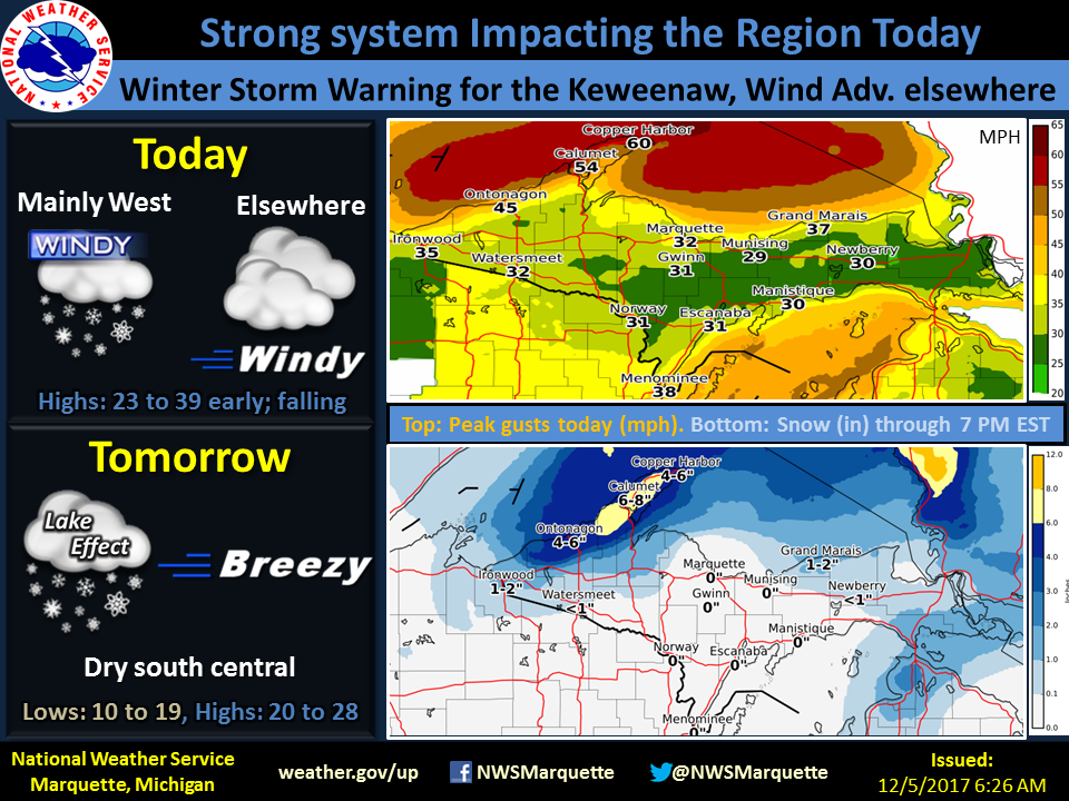
6:30 AM EST, Dec. 5th, 2017 Finally, the morning of the event, we posted updated maps of expected snowfall and wind gusts. |
 |
Media use of NWS Web News Stories is encouraged! Please acknowledge the NWS as the source of any news information accessed from this site. |
|