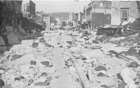
Winsted, Connecticut after the flood
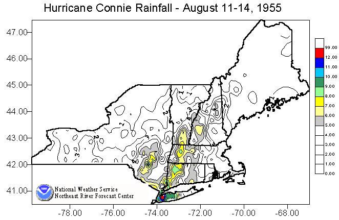
In little over a week, two hurricanes passed by Southern New England in August 1955 producing major flooding over much of the region. Hurricane Connie produced generally 4-6 inches of rainfall over southern New England on August 11 and 12. The result of this was to saturate the ground and bring river and reservoir levels to above normal levels.
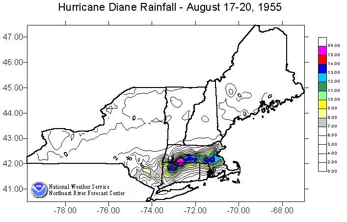
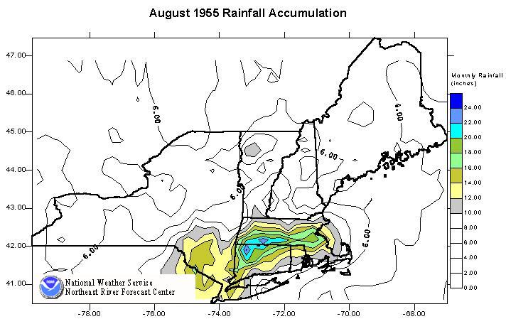
Hurricane Diane came a week later and dealt a massive punch to New England. Rainfall totals from Diane ranged up to nearly 20 inches over a two day period. The headwaters of the Farmington River in Connecticut recorded 18 inches in a 24-hour period. Both of these accumulations exceeded records for New England. The same is true of much of the flooding that resulted from these massive rainfall amounts.
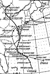
Path of Hurricanes Connie and Diane
With the strong intensity rainfall on saturated soil, the rise of the rivers was very rapid. Even the coastal regions of Eastern Massachusetts -- the Charles, Taunton, and Neponset Rivers -- experienced dramatic and rapid rises. On the Blackstone River, dam breaks caused significant flooding and destruction in Woonsocket RI. The entire reach of the Quinebaug River set new flow records.
In the Connecticut River valley, the most significant flows were experienced on the Chicopee, Westfield, and Farmington Rivers. However, on the mainstem, since the heaviest rainfalls did not reach far to the north and did not result in significant flows into Massachusetts, flooding, although significant, did not reach the record breaking volumes that occurred on the tributaries. In Westfield MA, the Westfield River exceeded its previous record stage by nearly 5 feet.
The Housatonic, Naugatuck, and Quinebaug Rivers also saw record or near-record flows. In New York, while the Hudson and Mohawk Rivers did not experience flooding, in southeastern New York, Rondout Creek and the Walkill River did see record breaking flooding.
While these hurricanes affected the entire Atlantic coast from North Carolina through Massachusetts, the state of Connecticut suffered the most damage. Of the 180 lives that were lost, 77 were in Connecticut. Of the 680 million dollars in property damage, over 350 million dollars occurred in Connecticut. Over 200 dams in New England suffered partial to total failure. Many of these were in the area immediately south of Worcester, in the Thames and Blackstone headwaters.
If August was not bad enough, two months later, a four day storm dumped an additional 12-14 inches of rain in southwest New England. This event was not as widespread as the August storms; however, record flood level were achieved in some locations of the Housatonic and Hudson River basins.
| River | Location | Flow | cfs/sq mi | Stage |
|---|---|---|---|---|
| Quinebaug | Quinebaug | 49300 cfs | 318 csm | 19.0 ft * |
| Connecticut | Hartford | 198,000 cfs | 19 csm | 30.6 ft |
| Housatonic | Gaylordsville | 51,800 cfs | 52 csm | 18.6 ft * |
| Pomeraug | Southbury | 29,400 cfs | 392 csm | 21.8 ft * |
| Naugatuck | Beacon Falls | 106,000 cfs | 408 csm | 25.7 ft * |
| Charles | Dover | 3220 cfs | 17 csm | 9.2 ft * |
| Blackstone | Woonsocket | 32,900 cfs | 79 csm | 21.8 ft * |
| Westfield | Westfield | 70,300 cfs | 141 csm | 34.2 ft * |
| W Br Farmington | New Boston | 34,300 cfs | 374 csm | 14.1 ft * |
| Rondout Cr | Rosendale | 30,900 cfs | 80.7 csm | 23.9 ft |
| Walkill | Gardiner | 30,600 cfs | 44 csm | 19.8 ft |
* represents flood of record

