Northeast RFC
River Forecast Center
The floods of March 1968 were not as dramatic as some earlier events in terms of the rainfall
amounts, nor did it seriously impact the major mainstem rivers of the region. However, its
impact in many ways was just as significant since its focus was on the heavily populated areas of
eastern Massachusetts and Rhode Island. No lives were lost due to the flooding; however,
damage estimates totalled about $37 million.
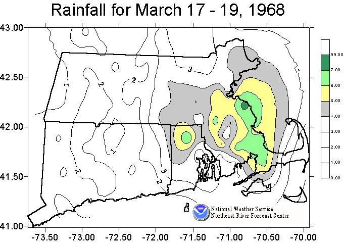
Two significant storms impacted southern New England in March 1968. The first was not major,
but it did combine with some snowmelt to bring a rise into many of the rivers and streams in the
region. The second storm occurred March 17-19 and delivered up to 7 inches of rain with the
heaviest amounts occurring just south of Boston.
The Ipswich, Charles, and Taunton River basins among others recorded floods of record during
this event.
| River | Station | Flow | cfs/sq mile | Stage |
|---|---|---|---|---|
| Ipswich | Ipswich | 2680 cfs | 22 csm | 8.4 ft |
| Charles | Dover | 3220 cfs | 18 csm | 8.7 ft * |
| Neponset | Norwood | 1140 cfs | 32 csm | 10.5 ft |
| Wading | Norton | 1460 cfs | 34 csm | 11.5 ft * |
| Blackstone | Woonsocket | 15,400 cfs | 37 csm | 14.6 ft |
| Pawcatuck | Westerly | 4470 cfs | 15 csm | 10.5 ft * |
US Dept of Commerce
National Oceanic and Atmospheric Administration
National Weather Service
Northeast RFC
46 Commerce Way
Norton, MA 02766
(508) 622-3300
Comments? Questions? Please Contact Us.

