Overview
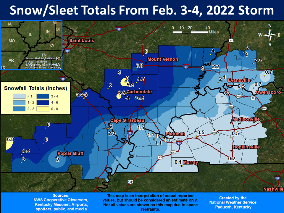
A strong cold front moved slowly southeast across the lower Ohio Valley and southeast Missouri on February 3-4. Ahead of the front, the precipitation was mostly rain along the Tennessee border of Christian County, KY. Immediately behind the front, an ice storm occurred over much of western Kentucky. Deeper into the cold air, a zone of heavy sleet fell near the Ohio River and much of southeast Missouri. Further northwest from Mount Vernon to Carbondale, Illinois, the cold air was deep enough for plenty of snow.Snow/Ice
A major winter storm dumped significant amounts of snow, sleet, and freezing rain. An ice storm was experienced across most of western Kentucky and southwest Indiana. A zone of heavy sleet was observed along the Ohio River and in parts of southeast Missouri. Further northwest, several inches of snow fell from Mount Vernon, Illinois across the Carbondale area into the Ozark foothills of southeast Missouri. Note: Some of the precipitation amounts over western Kentucky south of Madisonville and east of Paducah are ice amounts.
Photos
Coming soon...
| Caption (source) |
Caption (source) |
Caption (source) |
Caption (source) |
Storm Reports
Extensive power outages were reported in parts of western Kentucky, especially from Murray to Princeton, Madisonville, and Owensboro. Parts of southwest Indiana had scattered power outages. Power was restored to nearly all customers by Sunday night, February 6.
Additional storm reports will be posted here.
 |
Media use of NWS Web News Stories is encouraged! Please acknowledge the NWS as the source of any news information accessed from this site. |
|

