On Saturday, May 29, 1982, a deadly F4 tornado carved a 17-mile long path across Williamson County, Illinois, including the city of Marion. At times, the tornado was nearly a quarter mile wide. The tornado first touched down about 3 miles northwest of Carterville around 3:05 p.m. After moving southeast across Carterville to Crainville, the twister then paralleled Illinois Route 13 through Marion. On the ground for nearly 30 minutes, the tornado claimed 10 lives in Marion, injured nearly 200, and left approximately 1,000 persons homeless across Williamson County.
What follows is the description of the tornado's path taken from the May 1982 issue of Storm Data, a monthly publication of the National Climatic Data Center in Asheville, North Carolina.
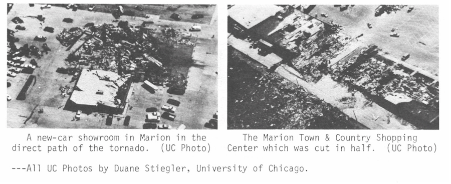
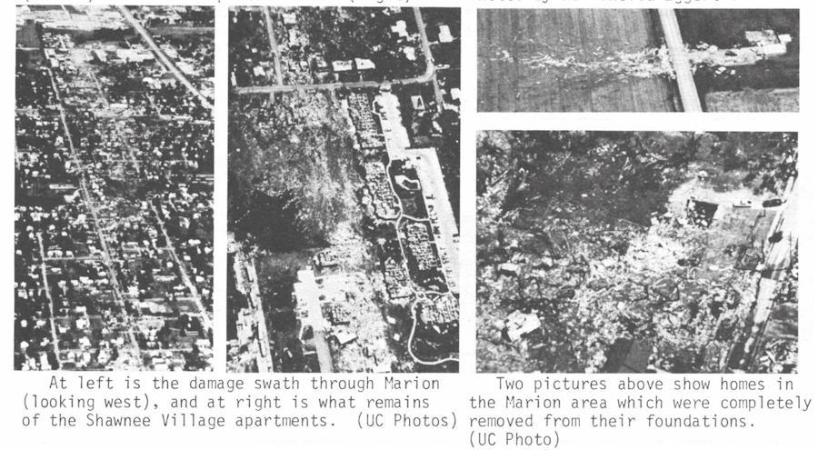
"Ten persons were killed and 181 persons were injured when a massive tornado cut a path through 3 towns in Williamson County and contained 3 separate vorticies rotating around the main tornado. The initial touchdown was approximately 4 miles northwest of Carterville and 1 mile north of Crab Orchard Lake. It lifted briefly, touching down in a subdivision of Carterville demolishing 2 homes and causing damage to several others. The tornado again lifted briefly and touched down again in downtown Carterville. It traveled through the east section of town and through Crainville where several homes, business buildings and many trees were damaged. The tornado then increased in size and several funnels were observed within the tornado. Extensive damage occurred at the Williamson County Airport between 1410 and 1415 CST. Then the tornado either changed course or formed a new funnel as it followed highway 13 through Marion. A truck plaza near Interstate 57 in western Marion was demolished. A car was struck on Interstate 57 and exploded. A motel and 3 shopping centers were damaged. Two of the 39 motel occupants were injured. The Shawnee Village 190 unit apartment complex was destroyed and 2 schools were severely damaged. One person died when a wall fell and 2 more died when they were literally blown out of their homes. In Marion a total of 161 homes and 47 businesses were destroyed; 59 homes and 29 businesses suffered damage. In Williamson County, 52 businesses were destroyed and 37 were heavily damaged. In total, 648 homes were damaged with 40% of these destroyed and 23% suffering major damage. Many persons were trapped under rubble. Over 200 cars were damaged or destroyed. The tornado lifted approximately 1 mile east-southeast of Routes 166 and 13; and the estimated damage was between 85 to 100 million dollars. The total homeless was approximately 1,000."
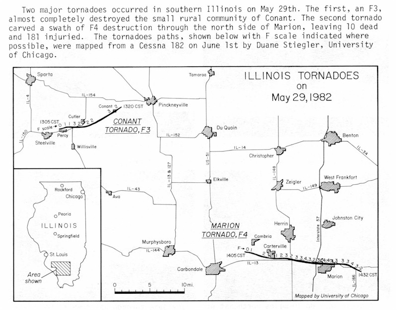
Also from the May 1982 issue of Storm Data is a map of the damage path for both the Conant F3 and Marion F4 tornadoes. Both were mapped on June 1, 1982, from a Cessna 182 by Duane Stiegler, University of Chicago. Click on the thumbnail below for a larger image.
In the days following the event, a very extensive damage assessment survey of the Williamson County tornado was conducted by Mr. Bob Hamilton, Meteorologist-In-Charge of the St. Louis NOAA National Weather Service Forecast Office in 1982. Click here to view the highlights of this report.
The official May 1982 Storm Data report was compiled by the NOAA National Weather Service Forecast Office in St. Louis, and published by the National Climatic Data Center in Asheville, North Carolina. Click here for excerpts from this report related to the Williamson County tornado. You will need a PDF reader to view this report. You may alternatively view most of this report in sections by visiting the Photos page on this site.
A review of the 12 UTC (7 a.m. CDT) 500 mb and surface analyses from the morning of May 29, 1982 reveals a great deal about the potential for severe thunderstorms later that day. The 12 UTC analysis had a 500 mb low over Montana, with a positively tilted trough extending south from the low into northern California. A high pressure ridge was situated from James Bay in Canada south into New York state. With a trough to our west and ridge in the east, this placed the immediate region in a west-southwesterly flow pattern. Looking at the finer scale, a shortwave disturbance was analyzed near the Missouri/Illinois border with west-northwest winds immediately behind it over western Missouri. In addition, a band of 20 to 30 knot southwest winds, perhaps some form of a weak jet max, was punching into central Oklahoma from New Mexico and Arizona.
On the 12 UTC surface chart, a cold front was draped from Minnesota southwest across Iowa, Kansas, Oklahoma, and into Texas. A triple point was found just south of Des Moines, Iowa, with a warm front jutting east across northern Illinois and Indiana. Morning dew points ranged from 65°F at St. Louis, Missouri and Louisville, Kentucky, to 72°F at Memphis, Tennessee. 70 or 71°F dew points were found in Fort Smith, Arkansas, Springfield and Cape Girardeau, Missouri, and Fort Campbell, Kentucky. An outflow boundary was draped over Central Illinois and Missouri from overnight convection that was decaying as it tracked east across the two states.
By early afternoon, archived surface observations from both Carbondale and Marion, Illinois (KMDH & KMWA) showed temperatures had reached the mid to upper 80s with dew points just above 70°F. Judging by the conditions at both the surface and several thousand feet up, all the necessary ingredients were present for the development of thunderstorms later that day, including moisture, lift, and instability.
(1.) Moisture - Southwest flow and morning dew points in the upper 60s to lower 70s indicated there was a steady stream of warm, moist Gulf of America air surging north across the Mississippi Delta Region into the Lower Ohio River Valley. By early afternoon, surface dew points likely ranged from 70 to 75°F over southern Illinois.
(2.) Lift - Afternoon satellite imagery showed a synoptic-scale circulation (the surface low) entering northwest Illinois. While the surface cold front likely had advanced into Missouri and the western fringe of Illinois by early afternoon, this was probably not the lifting mechanism that contributed directly to the thunderstorm development. The convection firing over southwest Illinois and southeast Missouri appeared to be along another boundary--more than likely the outflow boundary left over from overnight convection. The weak 500 mb jet max noted over the Southern Plains earlier in the day may have also contributed as a lifting mechanism as it headed northeast across the Ozarks by afternoon.
(3.) Instability - Intervals of midday sunshine boosted temperatures into the middle and upper 80s by early afternoon. This combined with 70's dew points certainly made for a very unstable air mass.
(4.) Wind Shear - The presence of moisture, lift, and instability certainly made the atmosphere ripe for thunderstorm development. While no significant speed or directional shear was detected in the surface or upper-air analyses, the boundary along which the Williamson County supercell thunderstorm tracked apparently provided enough localized shear for the supercell to form and eventually spin up a tornado.
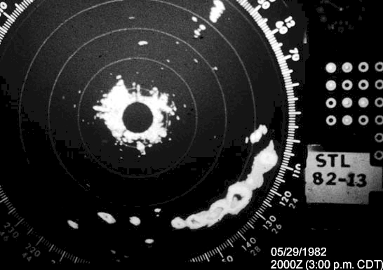
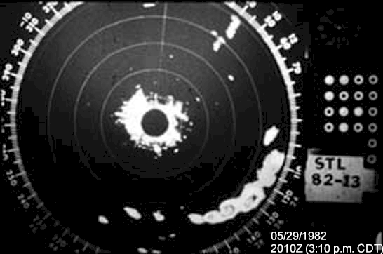
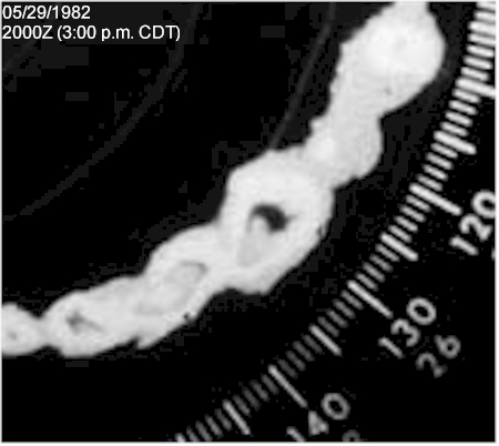
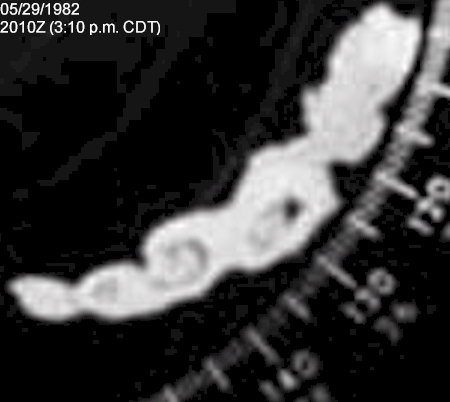
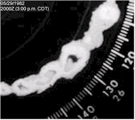
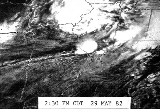
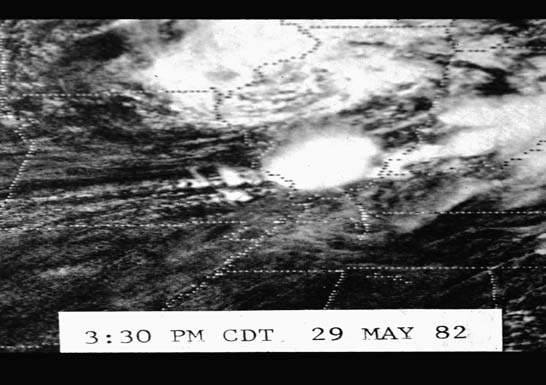
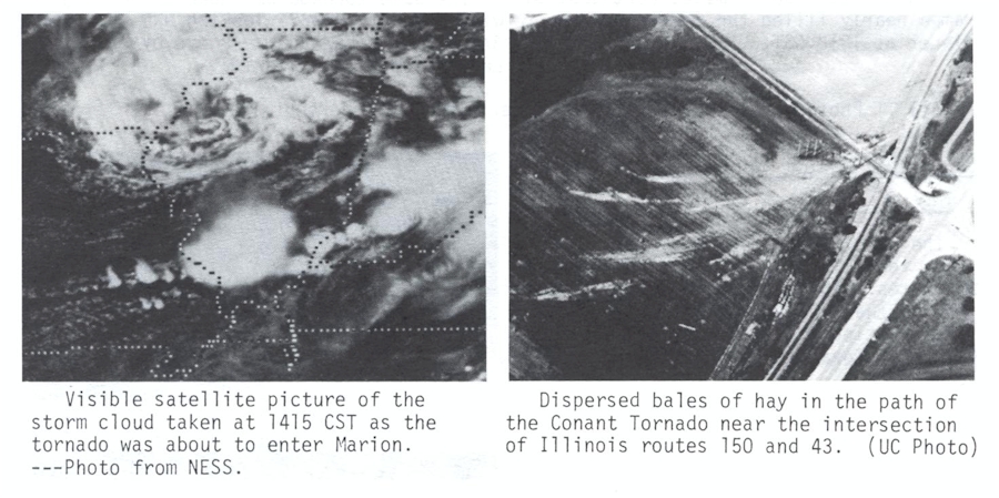
The first section contains radar and satellite imagery of the thunderstorm that produced the Marion tornado. The first two radar images were taken at 3:00 and 3:10 p.m. CDT respectively from the St. Louis WSR-57. The second two images are enlarged copies of the first two images for easier viewing. The final radar image is a loop of the third and fourth images. The strongest storm in the center of the image is the storm that produced the first reported tornado touchdown west-northwest of Carterville, Illinois at 3:05 p.m. CDT. Below the radar images are satellite pictures from 2:30 and 3:30 p.m. CDT respectively. All of these images are from the files of Dennis McCarthy, former Regional Director of NWS Central Region Headquarters.
 |
 |
 |
 |
 |
 |
 |
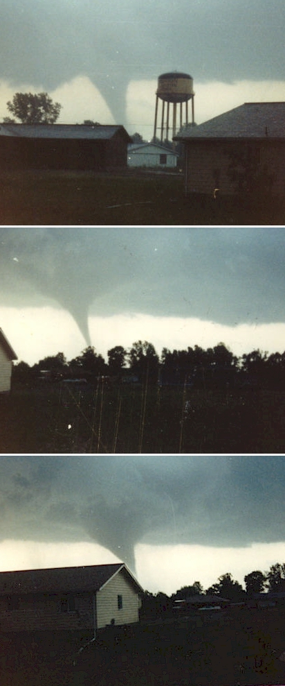
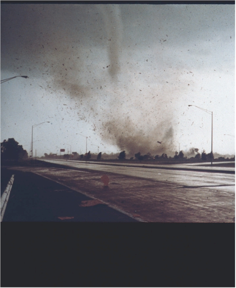
The next section contains impressive photographs of the actual tornado, shown as it moved east along Illinois Route 13 toward Marion. The left three pictures were shot from the southern portion of Herrin, Illinois, looking south-southeast toward Route 13. They were provided by Bill May, former resident of Herrin, and member of A.R.E.S. (Amateur Radio Emergency Services) when these pictures were taken. The picture on the right is a close-up shot of the tornado, looking southeast toward Marion from the Illinois Route 13 interchange of Interstate 57. While the identity of the person who took this picture is unknown, the ownership rights to this photograph belong to Don Fisher of Marion. We are using this picture with his permission.
 |
 |
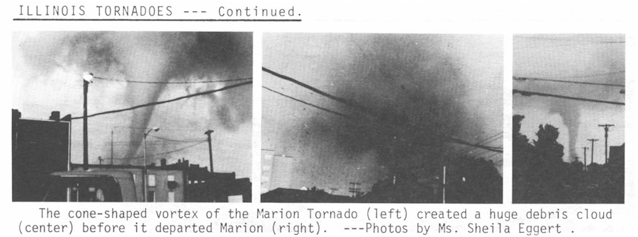
The final section contains excerpts from the official May 1982 Storm Data report related to the Williamson County tornado. This report was compiled by the NOAA National Weather Service Forecast Office in St. Louis, and published by the National Climatic Data Center in Asheville, North Carolina. Credits are contained in the captions underneath the photos.
 |
 |
 |
 |
Advanced technology and improved communication have certainly helped to better warning operations over the past few decades. Even with such systems as Doppler radar and the Advanced Weather Interactive Processing System, the warning process still has plenty of room for improvement. While radar is helping to detect more severe weather events than ever before, the warning forecasters at NOAA's National Weather Service still rely heavily on trained spotters to help correlate radar data with ground-truth information. These spotters range from those in the law enforcement community to emergency management and volunteer weather observers.
Everyone who worked at the NOAA National Weather Service Forecast Office in St. Louis, Missouri in 1982 and had input into this web site were quick to recall the tremendous service that law enforcement and spotter groups provided in relaying timely information to those who were issuing the warnings on May 29, 1982. Bob Hamilton, the Meteorologist-In-Charge of the St. Louis NOAA National Weather Service Forecast Office in 1982, said the event "provided a great example of the cooperation between law enforcement, civil defense, and local media in the warning process."
In particular, the efforts of Troopers Rheamond Evans and Paul Freeman, both now retired from Illinois State Police District 13 in DuQuoin, Illinois, were recognized with a "Special Service Award" after the Marion tornado event. Both troopers were on duty when the tornado touched down, and followed the tornado as it headed east along Route 13 into Marion. In fact, if it were not for the brave efforts of these unsung heroes, the death toll may have been much higher.
According to former NWS Central Region Director Dennis McCarthy, the brave effort of both Illinois State Police troopers "underscores the importance of timely ground-truth reports in the warning process and provides an example of the efforts law enforcement folks make during severe weather outbreaks."
The author of this page would like to thank the following agencies and individuals who directly assisted in compiling information for this web page:
National Weather Service, Central Region Headquarters, Kansas City, Missouri
National Weather Service Forecast Office, St. Louis, Missouri
National Climatic Data Center, Asheville, North Carolina
- Page authored by: Ryan J. Presley, Meteorologist, NWS Paducah (Retired)
 |
Media use of NWS Web News Stories is encouraged! Please acknowledge the NWS as the source of any news information accessed from this site. |
|

