Overview
A strong cold front moved rapidly east. A broken line of strong to severe thunderstorms formed along the front during the warmth of the afternoon hours over southeast Missouri. This line of storms progressed rapidly east across the lower Ohio Valley, accompanied by scattered reports of large hail and wind damage. National Weather Service storm damage surveys revealed 11 tornadoes occurred in our forecast area across portions of southeast Missouri, southern Illinois, and western Kentucky. The two strongest tornadoes were rated EF-2's. These occurred from far eastern Williamson County into Saline County Illinois and in Livingston County Kentucky.
|
|
||||||||||
|
||||||||||
|
Tornado #1 - Carterville, Illinois
Track Map %204-3-18.png) 
|
||||||||||||||||
|
Tornado #2 - Pittsburg, Illinois
Track Map %204-3-18.png)
|
||||||||||||||||
|
Tornado #3 - Galatia, Illinois
Track Map %204-3-18.png)
|
||||||||||||||||
|
Tornado #4 - Burna, Kentucky
Track Map %204-3-18.png)
|
||||||||||||||||
|
Tornado #5 - Metropolis, Illinois
Track Map %204-3-18.png)
|
||||||||||||||||
|
Tornado #6 - Clinton, Kentucky Northwest
Track Map 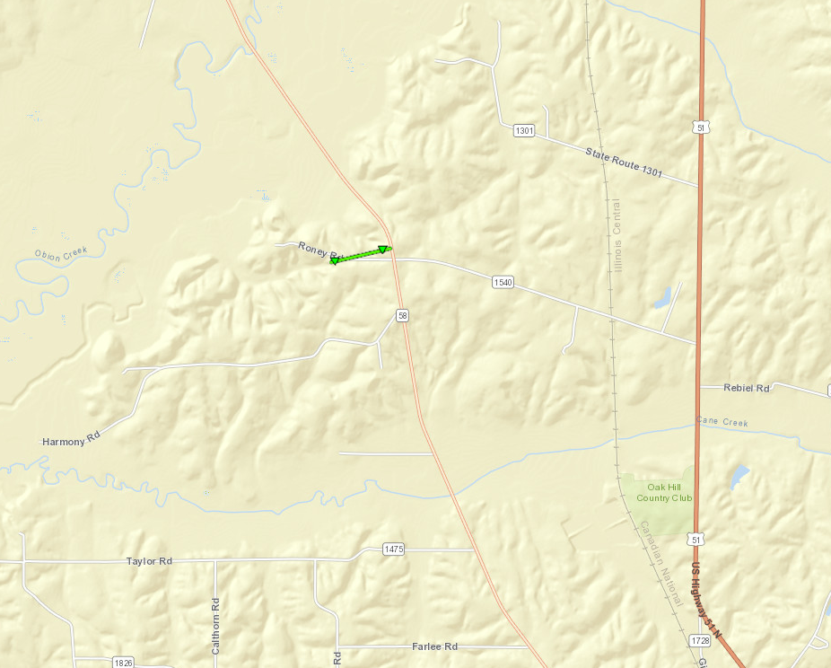
|
||||||||||||||||
|
Tornado #7 - Clinton, Kentucky Northeast
Track Map 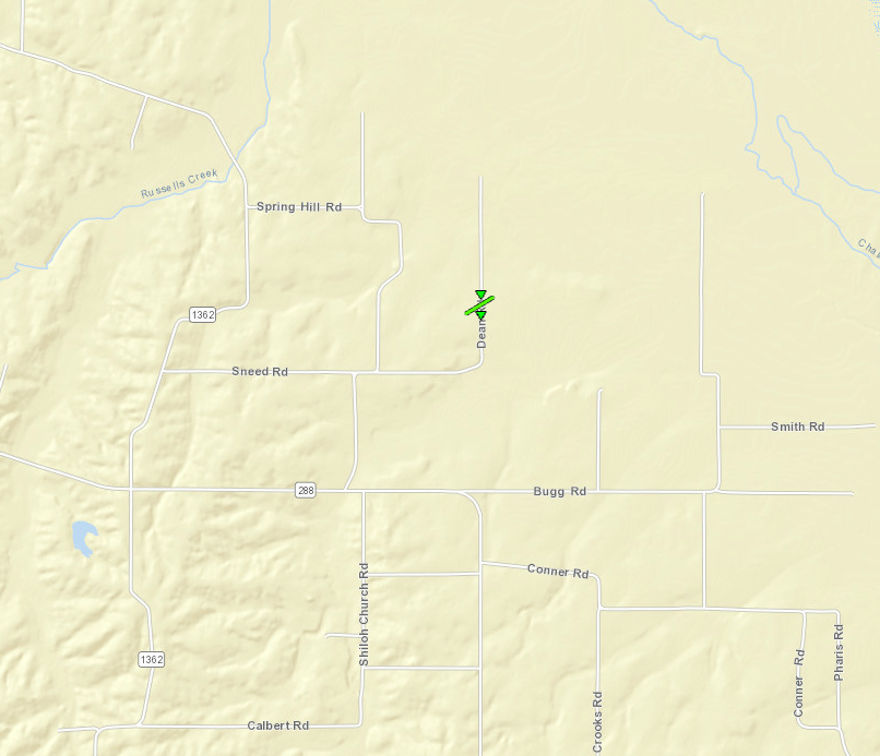
|
||||||||||||||||
|
Tornado #8 - Matthews, Missouri
Track Map %204-3-18.png)
|
||||||||||||||||
|
Tornado #9 - Baker, Missouri
Track Map %204-3-18.png)
|
||||||||||||||||
|
Tornado #10 - NE of New Haven, Illinois
Track Map %20tornado%20path%20map.PNG)
|
||||||||||||||||
|
Tornado #11 - NNE of Wingo, KY
Track Map %20Track%20Map.PNG)
|
||||||||||||||||
The Enhanced Fujita (EF) Scale classifies tornadoes into the following categories:
| EF0 Weak 65-85 mph |
EF1 Moderate 86-110 mph |
EF2 Significant 111-135 mph |
EF3 Severe 136-165 mph |
EF4 Extreme 166-200 mph |
EF5 Catastrophic 200+ mph |
 |
|||||
Wind & Hail:
Wind
Pockets of wind damage were reported. Much of the damage will be surveyed by the NWS to determine where tornadic activity occurred. In particular, a path of destructive winds across northern Williamson and Saline Counties in Illinois will be surveyed.
Hail
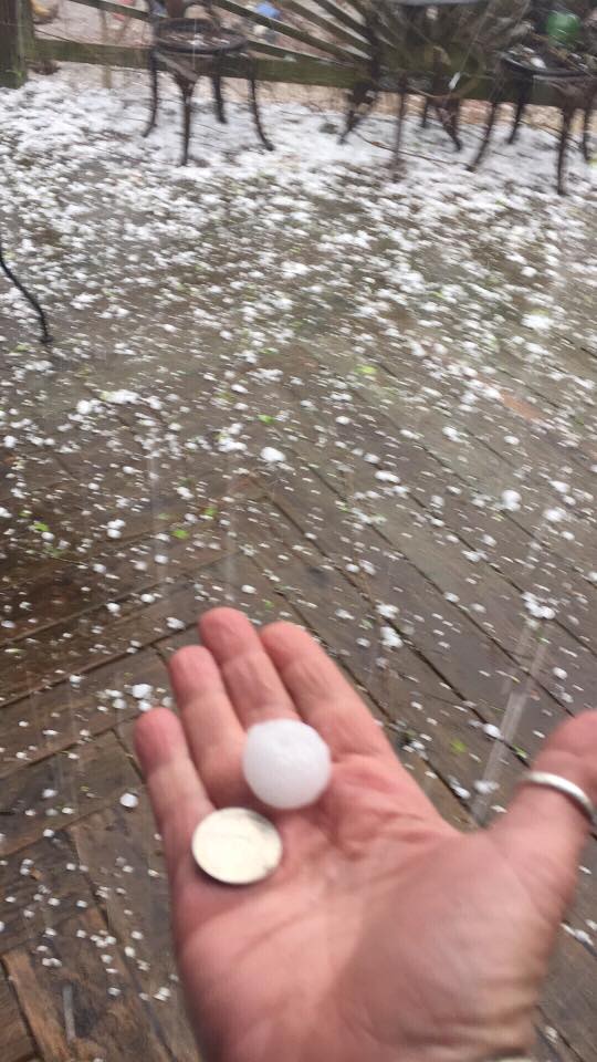
Some very large hail was reported with the storms as they moved into southeast Missouri. The largest hailstone was about 3 inches in diameter, which is slightly larger than a baseball. This hail occurred in the Poplar Bluff area. Quarter to golf ball size hail was reported at a few other locations in southeast Missouri and southwest Illinois. As the storms moved east, the incidents of large hail decreased.
Photos:
 |
 |
 |
 |
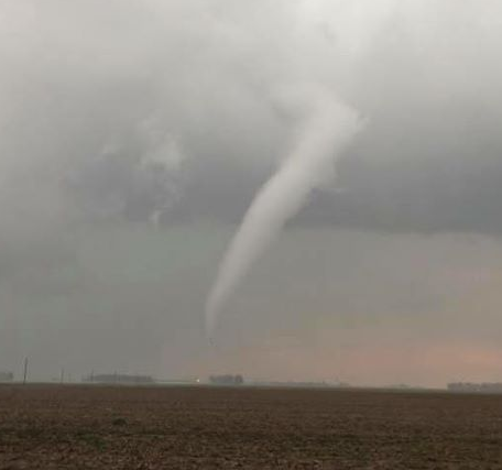
| Hail around 3 inches in diameter west of Poplar Bluff, MO via Velvet Jones-Krueger | Quarter-size hail west of Poplar Bluff, MO via Velvet Jones-Krueger | Tornado 7 miles south of Essex, MO (source: John Holt) |
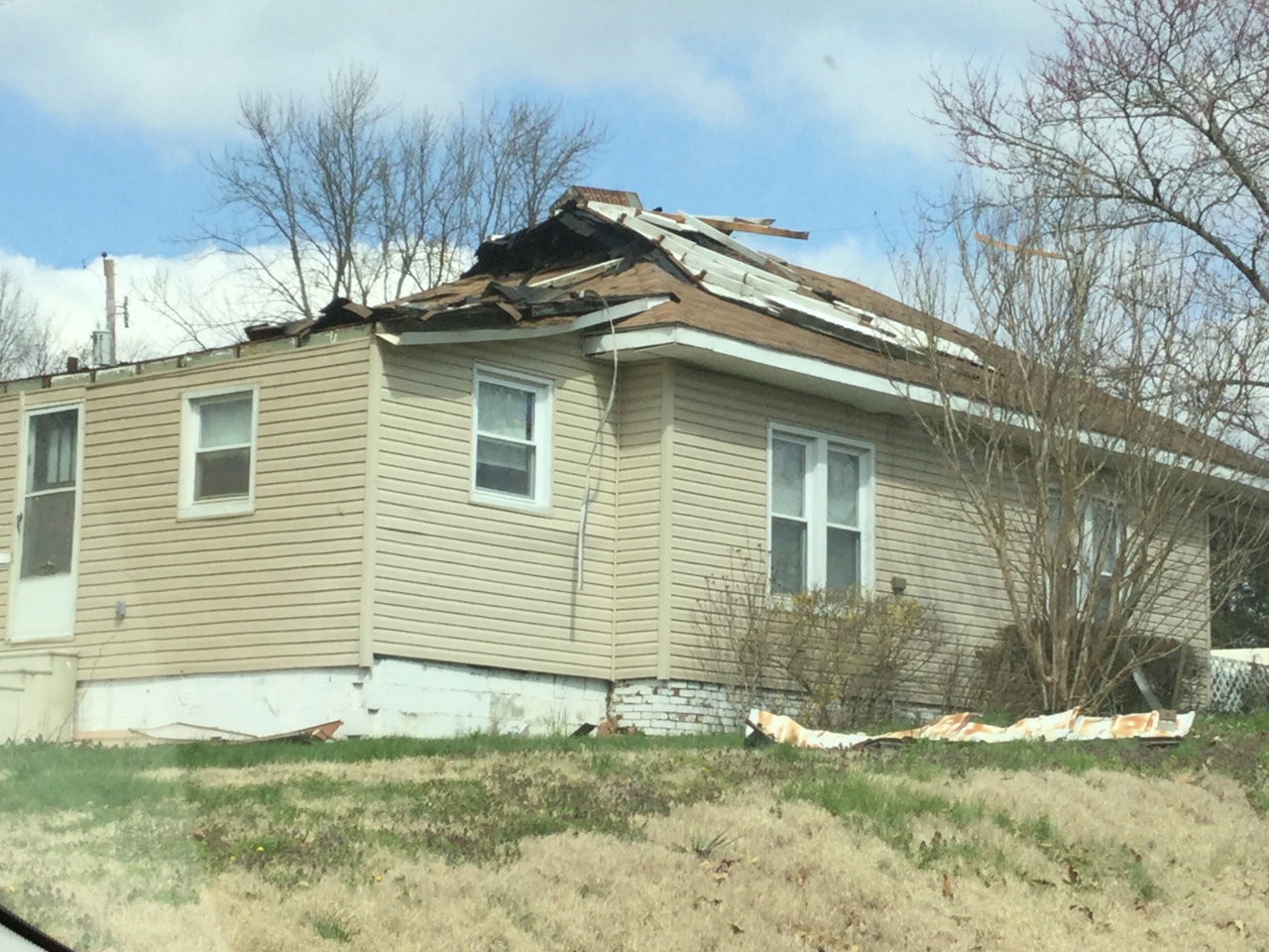
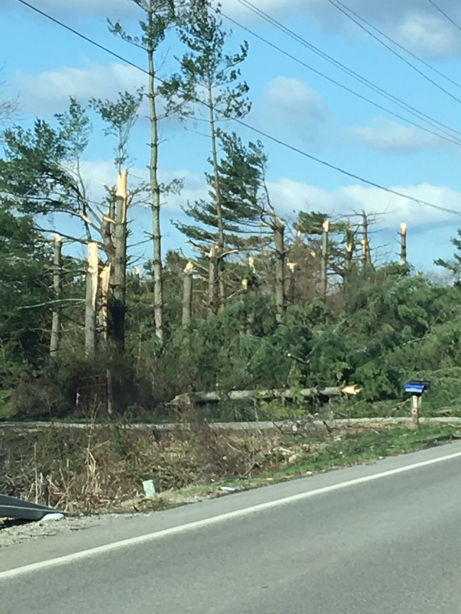
Tornado damage in Williamson County Illinois via NWS Storm Damage Survey |
 |
 |
 |
 |
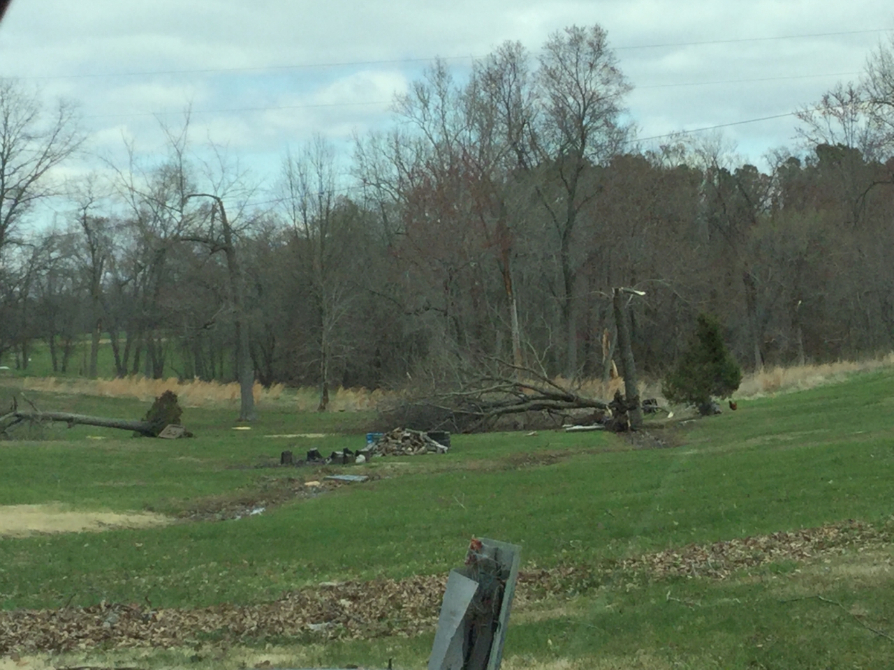
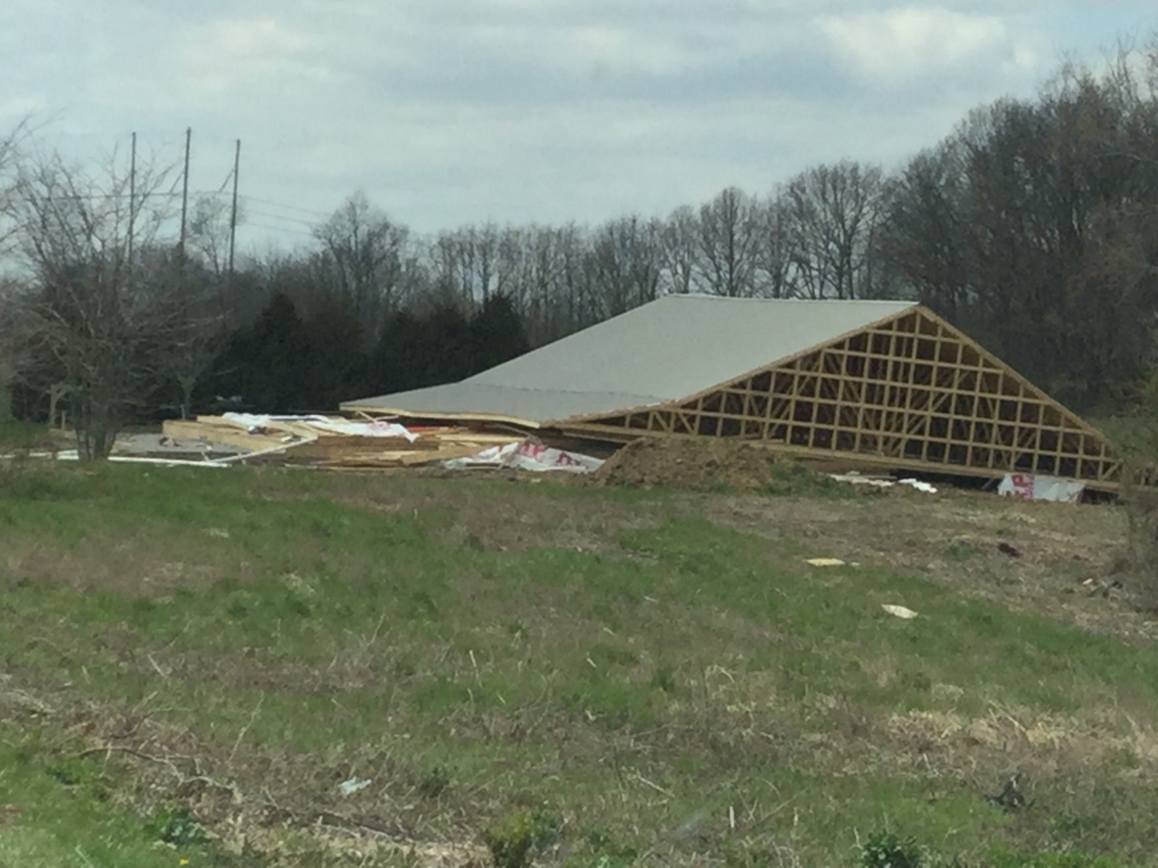
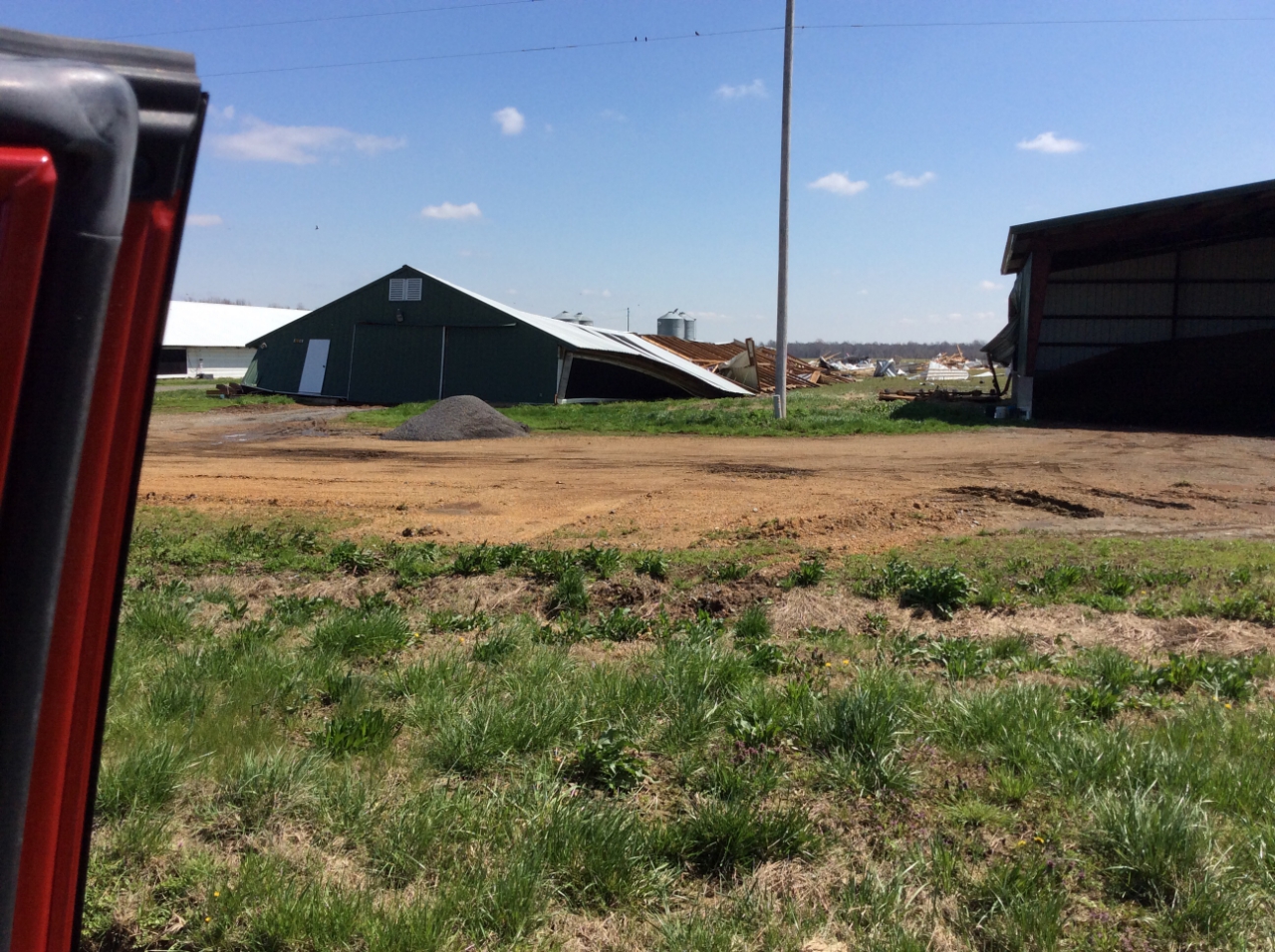
| Tornado damage in Williamson County Illinois via NWS Storm Damage Survey | Tornado damage in Williamson County Illinois via NWS Storm Damage Survey | Tornado damage in Williamson County Illinois via NWS Storm Damage Survey | Tornado damage in Livingston County Kentucky via NWS Storm Damage Survey |
 |
 |
||
| Tornado damage in Hickman County Kentucky via NWS Storm Damage Survey | Storm damage in Saline County Illinois along Hwy 34 via Scott Riley |
Radar:
Click here for a radar loop of this event
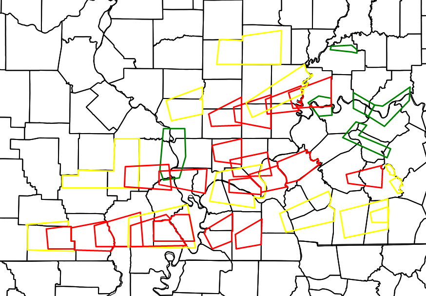 |
| Map above shows all warning polygons issued during this event. Red are Tornado Warnings, Yellow are Severe Thunderstorm Warnings, and Green are River Flood Warnings. |
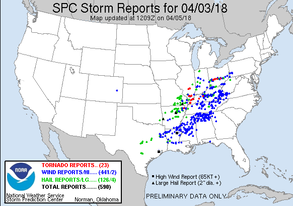
Storm Reports
Click here for an interactive map of local storm reports from this event
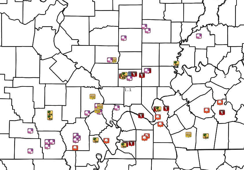 |
PRELIMINARY LOCAL STORM REPORT...SUMMARY
NATIONAL WEATHER SERVICE PADUCAH KY
923 PM CDT TUE APR 3 2018

..TIME...   ...EVENT...      ...CITY LOCATION...     ...LAT.LON...
..DATE...   ....MAG....      ..COUNTY LOCATION..ST.. ...SOURCE....
            ..REMARKS..

0425 PM     HAIL             DONIPHAN                36.62N 90.82W
04/03/2018  M1.00 INCH       RIPLEY             MO   TRAINED SPOTTER

            LATE REPORT. QUARTER SIZE HAIL REPORTED IN THE COMMUNITY.


0430 PM     HAIL             4 W ELLSINORE           36.93N 90.82W
04/03/2018  M1.00 INCH       CARTER             MO   TRAINED SPOTTER

            REPORTED WEST OF ELLSINORE.

0445 PM     HAIL             7 SW POPLAR BLUFF       36.69N 90.50W
04/03/2018  M0.50 INCH       BUTLER             MO   EMERGENCY MNGR

0449 PM     HAIL             POPLAR BLUFF            36.76N 90.41W
04/03/2018  E0.50 INCH       BUTLER             MO   EMERGENCY MNGR

            MARBLE SIZE HAIL REPORTED ON WEST SIDE OF TOWN.

0452 PM     HAIL             1 W WOODLAWN            38.33N 89.05W
04/03/2018  M0.88 INCH       JEFFERSON          IL   TRAINED SPOTTER

0453 PM     HAIL             4 W POPLAR BLUFF        36.76N 90.48W
04/03/2018  M2.00 INCH       BUTLER             MO   TRAINED SPOTTER

0455 PM     TSTM WND GST     W DU QUOIN              38.00N 89.24W
04/03/2018  M72.00 MPH       PERRY              IL   TRAINED SPOTTER

0455 PM     HAIL             4 W DU QUOIN            38.00N 89.31W
04/03/2018  M1.00 INCH       PERRY              IL   TRAINED SPOTTER

0455 PM     HAIL             POPLAR BLUFF            36.76N 90.41W
04/03/2018  E3.00 INCH       BUTLER             MO   PUBLIC

            REPORTED BY MEDIA PHOTO FROM PUBLIC.

0455 PM     HAIL             5 W POPLAR BLUFF        36.76N 90.50W
04/03/2018  M0.88 INCH       BUTLER             MO   TRAINED SPOTTER

0455 PM     HAIL             POPLAR BLUFF            36.76N 90.41W
04/03/2018  M1.50 INCH       BUTLER             MO   EMERGENCY MNGR

            PING PONG HAIL REPORTED IN THE COMMUNITY

0507 PM     TSTM WND DMG     GREENVILLE              37.13N 90.45W
04/03/2018                   WAYNE              MO   UTILITY COMPANY

            POWER OUTAGES REPORTED THROUGHOUT THE COUNTY.

0510 PM     HAIL             CAPE GIRARDEAU          37.31N 89.55W
04/03/2018  M1.75 INCH       CAPE GIRARDEAU     MO   EMERGENCY MNGR

            GOLFBALL SIZE HAIL REPORTED IN THE COMMUNTIY OF
            ALLENVILLE.

0512 PM     HAIL             CAPE GIRARDEAU          37.31N 89.55W
04/03/2018  M0.75 INCH       CAPE GIRARDEAU     MO   EMERGENCY MNGR

            WIND GUSTS ESTIMATED 45 MPH WITH THIS STORM

0513 PM     TSTM WND GST     FRUITLAND               37.45N 89.64W
04/03/2018  E55.00 MPH       CAPE GIRARDEAU     MO   TRAINED SPOTTER

            WIND GUSTS ESTIMATED 50 TO 55 MPH

0515 PM     HAIL             CAPE GIRARDEAU          37.31N 89.55W
04/03/2018  M0.50 INCH       CAPE GIRARDEAU     MO   TRAINED SPOTTER

            MARBLE HAIL REPORTED NEAR MM95 ON I-55

0517 PM     HAIL             ORCHARDVILLE            38.50N 88.66W
04/03/2018  M0.88 INCH       WAYNE              IL   TRAINED SPOTTER

0518 PM     HAIL             6 N WAYNE CITY          38.44N 88.59W
04/03/2018  M0.50 INCH       WAYNE              IL   TRAINED SPOTTER

            NICKEL SIZE HAIL WITH WIND GUST 52 MPH

0520 PM     TSTM WND DMG     CRAINVILLE              37.75N 89.06W
04/03/2018                   WILLIAMSON         IL   BROADCAST MEDIA

            LATE REPORT. TREES DOWN AND METAL ROOF PEELED BACK.

0520 PM     HAIL             DELTA                   37.20N 89.74W
04/03/2018  M0.88 INCH       CAPE GIRARDEAU     MO   TRAINED SPOTTER

0525 PM     HAIL             1 E SCOTT CITY          37.22N 89.51W
04/03/2018  M1.00 INCH       SCOTT              MO   TRAINED SPOTTER

0525 PM     TSTM WND DMG     ENERGY                  37.78N 89.03W
04/03/2018                   WILLIAMSON         IL   FIRE DEPT/RESCUE

            LATE REPORT. MULTIPLE STRUCTURES DAMAGED. RELAYED VIA
            FIRE/RESCUE VIDEO.

0525 PM     TSTM WND DMG     ENERGY                  37.78N 89.03W
04/03/2018                   WILLIAMSON         IL   FIRE DEPT/RESCUE

            LATE REPORT. MULTIPLE STRUCTURES DAMAGED. REPORTED FROM
            VIDEO TAKEN BY FIRE/RESUCE.

0529 PM     TSTM WND GST     5 S CAPE GIRARDEAU      37.24N 89.55W
04/03/2018  M58.00 MPH       SCOTT              MO   ASOS

            REPORTED AT THE CAPE GIRARDEAU REGIONAL AIRPORT WHICH
            SETS IN SCOTT COUNTY MISSOURI. ONE QUARTER MILE
            VISIBILITY REPORTED WITH THIS STORM.

0534 PM     HAIL             DEXTER                  36.79N 89.96W
04/03/2018  M1.00 INCH       STODDARD           MO   PUBLIC

            QUARTER SIZE HAIL REPORTED.

0537 PM     TORNADO          2 NNE SPILLERTOWN       37.79N 88.91W
04/03/2018                   WILLIAMSON         IL   LAW ENFORCEMENT

            LATE REPORT. ILLINOIS STATE POLICE REPORT COMFIRMED
            TORNADO

0538 PM     HAIL             5 N DEXTER              36.86N 89.96W
04/03/2018  M0.75 INCH       STODDARD           MO   TRAINED SPOTTER

            DIME SIZE HAIL REPORTED ALONG HIGHWAY 25.

0540 PM     HAIL             DEXTER                  36.79N 89.96W
04/03/2018  M1.25 INCH       STODDARD           MO   EMERGENCY MNGR

            HALF DOLLAR SIZE HAIL REPORT

0545 PM     HAIL             EAST CAPE GIRARDEAU     37.30N 89.50W
04/03/2018  M0.75 INCH       ALEXANDER          IL   TRAINED SPOTTER

            DIME SIZE HAIL REPORTED.

0545 PM     TSTM WND DMG     ENERGY                  37.78N 89.03W
04/03/2018                   WILLIAMSON         IL   TRAINED SPOTTER

            TREE BLOCKING ROAD.

0549 PM     FUNNEL CLOUD     BERNIE                  36.67N 89.97W
04/03/2018                   STODDARD           MO   TRAINED SPOTTER

            REPORTED NNE OF COMMUNITY.

0550 PM     TSTM WND GST     EAST CAPE GIRARDEAU     37.30N 89.50W
04/03/2018  M50.00 MPH       ALEXANDER          IL   TRAINED SPOTTER

0550 PM     HAIL             DEXTER                  36.79N 89.96W
04/03/2018  M1.75 INCH       STODDARD           MO   PUBLIC

            GOLF BALL SIZE HAIL REPORTED.

0553 PM     HAIL             ULLIN                   37.28N 89.18W
04/03/2018  M1.00 INCH       PULASKI            IL   TRAINED SPOTTER

            REPORTED ALONG INTERSTATE 57

0555 PM     FUNNEL CLOUD     MORTONS GAP             37.24N 87.47W
04/03/2018                   HOPKINS            KY   TRAINED SPOTTER

            REPORTED IN COMMUNITY.

0608 PM     TORNADO          GREENVILLE              37.21N 87.18W
04/03/2018                   MUHLENBERG         KY   LAW ENFORCEMENT

            ...UNCOMFIRMED...TORNADO PERIODIC TOUCHDOWNS ON HIGHWAY
            181 NEAR THE COMMUNTIY.

0611 PM     HEAVY RAIN       GOREVILLE               37.56N 88.97W
04/03/2018  M1.10 INCH       JOHNSON            IL   TRAINED SPOTTER

            15 MINUTE RAINFALL ON SOUTH SIDE OF LAKE OF EYGPT

0612 PM     TORNADO          2 E GALATIA             37.84N 88.58W
04/03/2018                   SALINE             IL   LAW ENFORCEMENT

            REPORT OF TORNADO AND DAMAGE TO HOME IN THE GALATIA AREA.
            ...TORNADO UNCONFIRMED...9 HOMES DAMAGED ALONG HARPER
            ROAD. 3 TO 4 HOMES DESTROYED. 2 BARNS/POLEBARNS DAMAGED.
            ROOF OFF OF HOUSE ALONG BANK LICK ROAD.

0624 PM     TSTM WND DMG     2 N MATTHEWS            36.79N 89.58W
04/03/2018                   NEW MADRID         MO   EMERGENCY MNGR

            TWO STRUCTURES DOWN AS WELL AS POWER POLES ALONG STATE
            HIGHWAY FF NEAR CR820

0638 PM     FUNNEL CLOUD     BREMEN                  37.36N 87.22W
04/03/2018                   MUHLENBERG         KY   EMERGENCY MNGR

            RELAYED TO EM...PUBLIC REPORT OF 3 FUNNEL CLOUDS BUT EM
            CAN NOT COMFIRM

0642 PM     FUNNEL CLOUD     EAST PRAIRIE            36.78N 89.38W
04/03/2018                   MISSISSIPPI        MO   TRAINED SPOTTER

            FUNNEL CLOUD MOVING EASTWARD. TELEPHONE POLES DOWN.

0649 PM     FUNNEL CLOUD     SMITHLAND               37.14N 88.40W
04/03/2018                   LIVINGSTON         KY   TRAINED SPOTTER

            LOCATED BETWEEN THE DAM AND THE COMMUNITY.

0702 PM     TORNADO          SALEM                   37.27N 88.24W
04/03/2018                   LIVINGSTON         KY   PUBLIC

            TORNADO REPORTED NEAR THE COMMUNITY RELAYED THROUGH
            TRAINED SPOTTER.

0705 PM     TSTM WND DMG     MARION                  37.73N 88.94W
04/03/2018                   WILLIAMSON         IL   UTILITY COMPANY

            TIME UNKNOWN...399 CUSTOMERS LOST POWER THROUGHOUT THE
            COUNTY.

0711 PM     TSTM WND DMG     4 NW CLINTON            36.71N 89.05W
04/03/2018                   HICKMAN            KY   EMERGENCY MNGR

            TREE ON MOBILE HOME AT INTERSECTION OF STATE HIGHWAY 1540
            AND 58 WEST. NO INJURIES REPORTED. RESCUE SQUAD
            RESPONDED.

0711 PM     FUNNEL CLOUD     CALVERT CITY            37.03N 88.35W
04/03/2018                   MARSHALL           KY   TRAINED SPOTTER

            REPORTED NNW OF COMMUNITY NEAR TENNESSEE RIVER.

0730 PM     TSTM WND DMG     BURNA                   37.26N 88.39W
04/03/2018                   LIVINGSTON         KY   EMERGENCY MNGR

            TIME ESTIMATED. BARN AND HOUSE DAMAGED.

0730 PM     HAIL             MARION                  37.73N 88.94W
04/03/2018  M0.75 INCH       WILLIAMSON         IL   STORM CHASER

0743 PM     FUNNEL CLOUD     3 NE HICKORY            36.85N 88.61W
04/03/2018                   GRAVES             KY   LAW ENFORCEMENT

            REPORTED BY STATE POLICE. ALONG HIGHWAY 45.

0744 PM     FUNNEL CLOUD     HICKORY                 36.82N 88.65W
04/03/2018                   GRAVES             KY   LAW ENFORCEMENT

            REPORTED BY STATE POLICE ALONG HIGHWAY 45.

0749 PM     HAIL             GALATIA                 37.84N 88.61W
04/03/2018  M1.00 INCH       SALINE             IL   TRAINED SPOTTER

0750 PM     TSTM WND GST     CADIZ                   36.87N 87.82W
04/03/2018  M49.00 MPH       TRIGG              KY   MESONET

0805 PM     TSTM WND GST     HOPKINSVILLE            36.85N 87.49W
04/03/2018  M60.00 MPH       CHRISTIAN          KY   EMERGENCY MNGR

            MEASURED AT INTERSECTION OF I-24 AND COX MILL ROAD JUST
            SOUTH OF TOWN.

0808 PM     TSTM WND DMG     HOPKINSVILLE            36.85N 87.49W
04/03/2018                   CHRISTIAN          KY   EMERGENCY MNGR

            PART OF A ROOF OFF A BUILDING ON EAST NINTH STREET NEAR
            THE INTERSECTION OF CLAY STREET. TIME RADAR ESTIMATED.

0822 PM     HEAVY RAIN       OWENSBORO               37.76N 87.12W
04/03/2018  E2.00 INCH       DAVIESS            KY   TRAINED SPOTTER

            ESTIMATED RAINFALL ACCUMULATION WITHIN 45 MINUTES.


&&
Environment
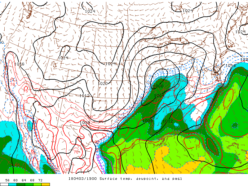
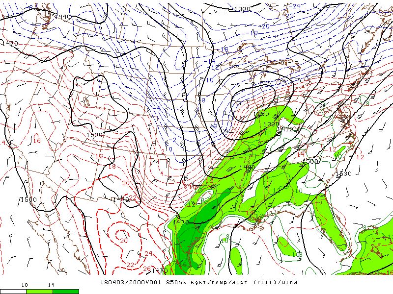
A strong cold front moved rapidly east. A broken line of strong to severe thunderstorms formed along the front during the warmth of the afternoon hours over southeast Missouri. This line of storms progressed rapidly east across the lower Ohio Valley, accompanied by scattered reports of large hail and wind damage. Surface-based instability was moderately strong when the storms developed, then decreased as the event progressed. Winds aloft were quite strong, with 850 mb winds around 50 knots.
 |
 |
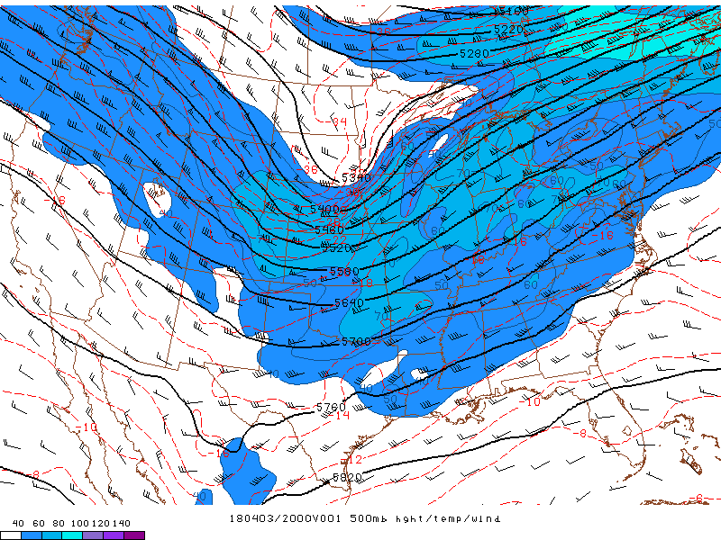 |
| Surface Pressure, Dewpoint, and Temperature valid at 2 PM | 850mb Height/Temp/Wind valid at 3 PM | 500mb Height/Temp/Wind valid at 3 PM |
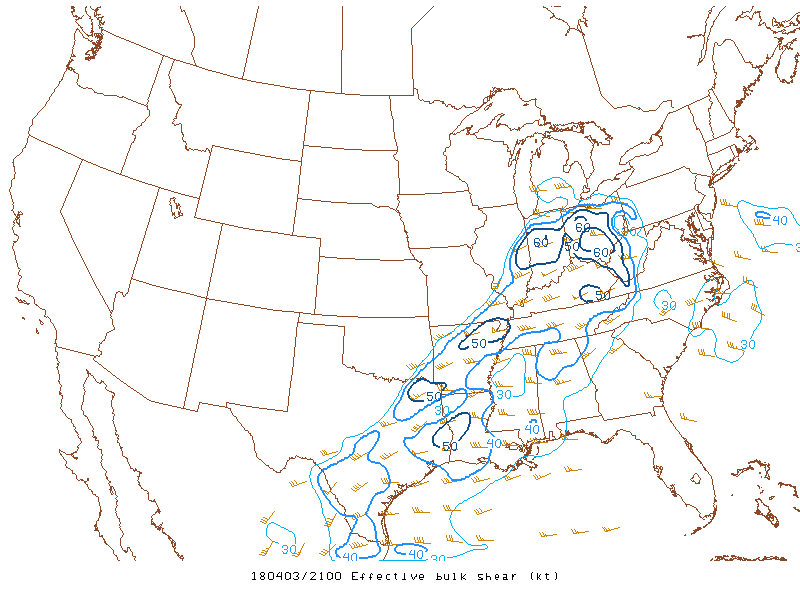
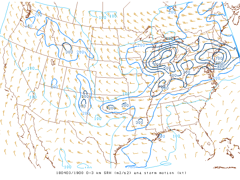
Near-storm environment:
 |
 |
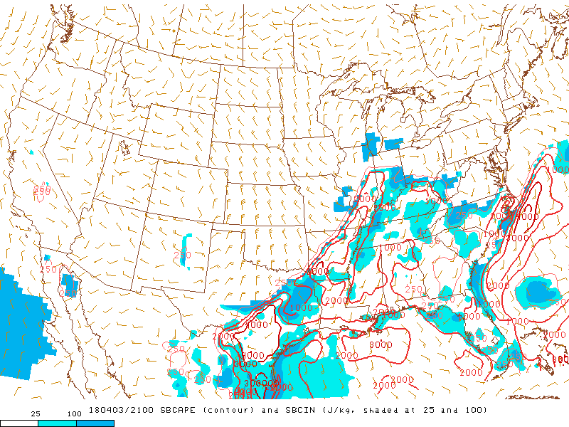 |
| Effective Bulk Shear valid at 4 PM | 0-3km Storm Relative Helicity valid at 2 PM | Surface Based CAPE valid at 4 PM |
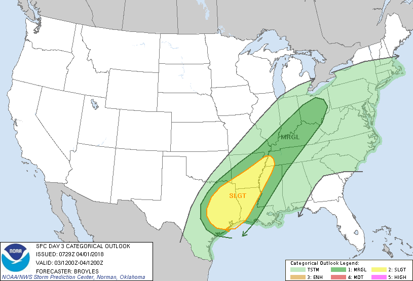
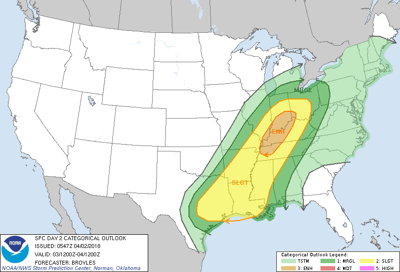
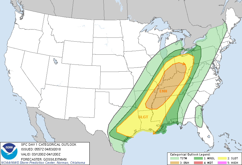
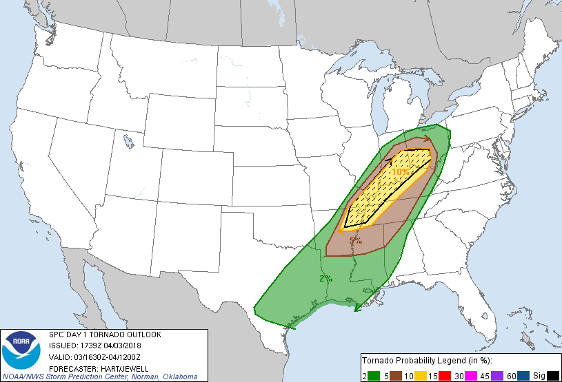
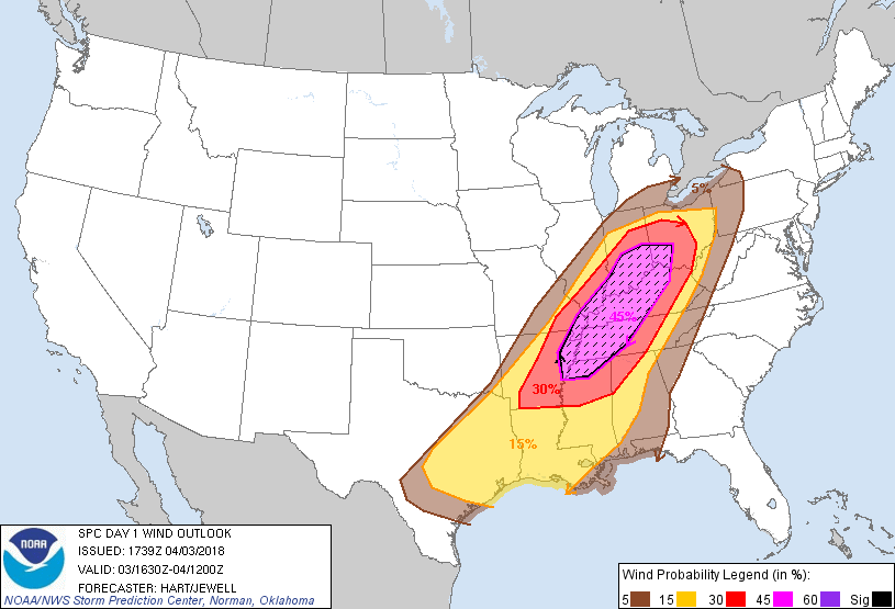
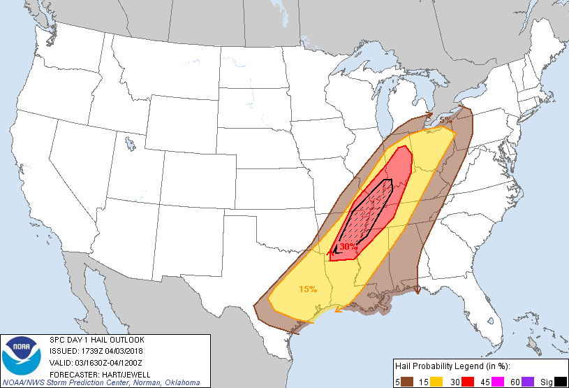
Convective Outlooks Issued from the Storm Prediction Center:
 |
 |
 |
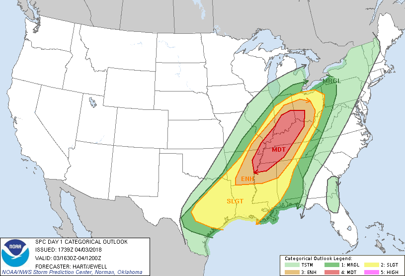 |
| SPC Day 3 Outlook | SPC Day 2 Outlook | SPC Day 1 Outlook (Early Morning) | SPC Day 1 Outlook (Late Morning Update) |
 |
 |
 |
 |
| SPC Day 1 Tornado Probabilities (Late Morning Update) | SPC Day 1 Wind Probabilities (Late Morning Update) | SPC Day 1 Hail Probabilities (Late Morning Update) | SPC Local Storm Reports Issued |
 |
Media use of NWS Web News Stories is encouraged! Please acknowledge the NWS as the source of any news information accessed from this site. |
|

