Overview
Multiple rounds of thunderstorms impacted the region on the last day of May. Damaging winds, large hail, flooding, and 3 tornadoes were observed with this event. The first round of storms moved through southern Illinois mainly north of Route 13 and into southwest Indiana and northwest Kentucky during the morning and early afternoon hours. Widespread damaging winds were associated with this line of storms. Scattered thunderstorm development then began by mid to late afternoon, with coverage increasing as we progressed further into the evening hours. Even after midnight, storms were still ongoing mainly up in southwest Indiana. By this time flooding had become the main threat.Tornadoes:
|
|
||||||||||
|
||||||||||
|
Tornado #1 - Fruitland, Missouri East
Track Map %205-31-18.png) 
|
||||||||||||||||
|
Tornado #2 - Wolf Lake, Illinois #1
Track Map %20%232%205-31-18.png)
|
||||||||||||||||
|
Tornado #3 - Wolf Lake, Illinois #2
Track Map %20%231%205-31-18.png)
|
||||||||||||||||
The Enhanced Fujita (EF) Scale classifies tornadoes into the following categories:
| EF0 Weak 65-85 mph |
EF1 Moderate 86-110 mph |
EF2 Significant 111-135 mph |
EF3 Severe 136-165 mph |
EF4 Extreme 166-200 mph |
EF5 Catastrophic 200+ mph |
 |
|||||
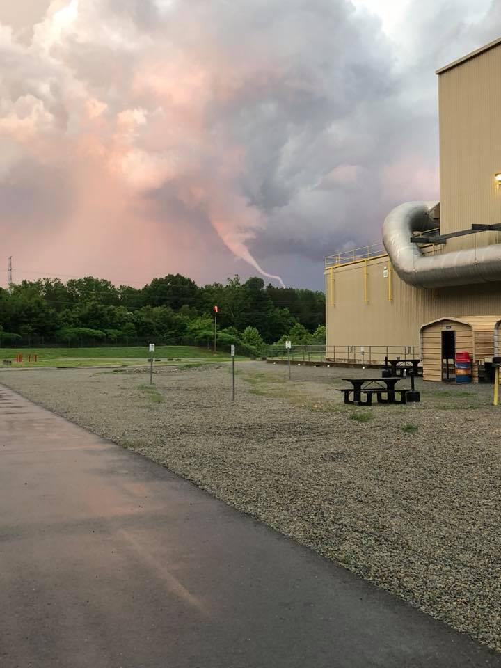
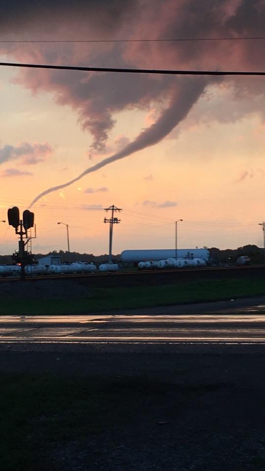
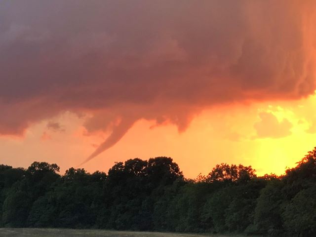
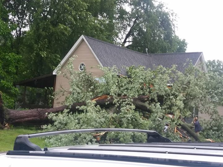
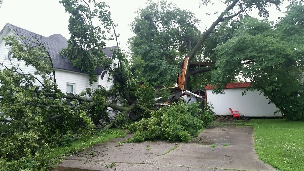
Photos:
 |
 |
 |
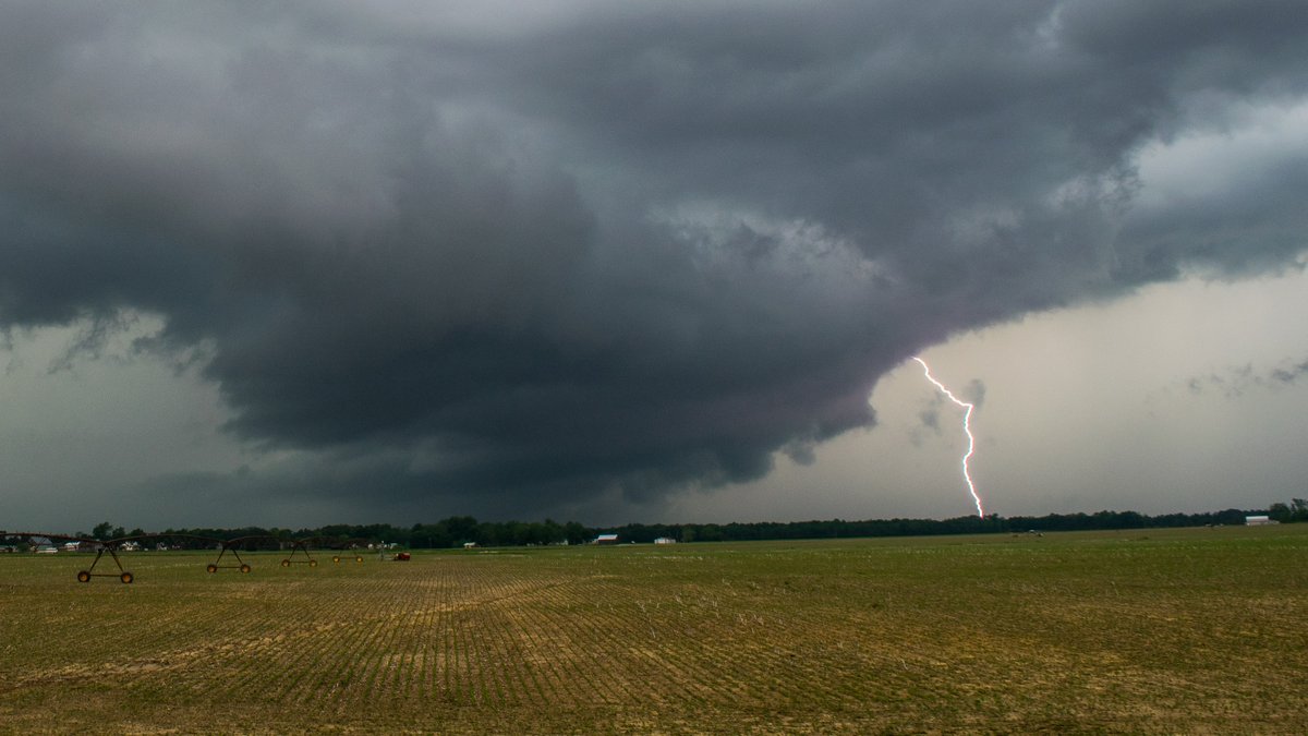 |
| Union County IL tornado from Proctor and Gamble looking toward Wolf Lake via Chris Keppner | Stovepipe tornado looking towards Wolf Lake, IL via Kami Hinkle | Possible tornado in Union County, IL via Crystal Wright Gurley | Lighting and storm clouds via Chris Conley |
 |
 |
 |
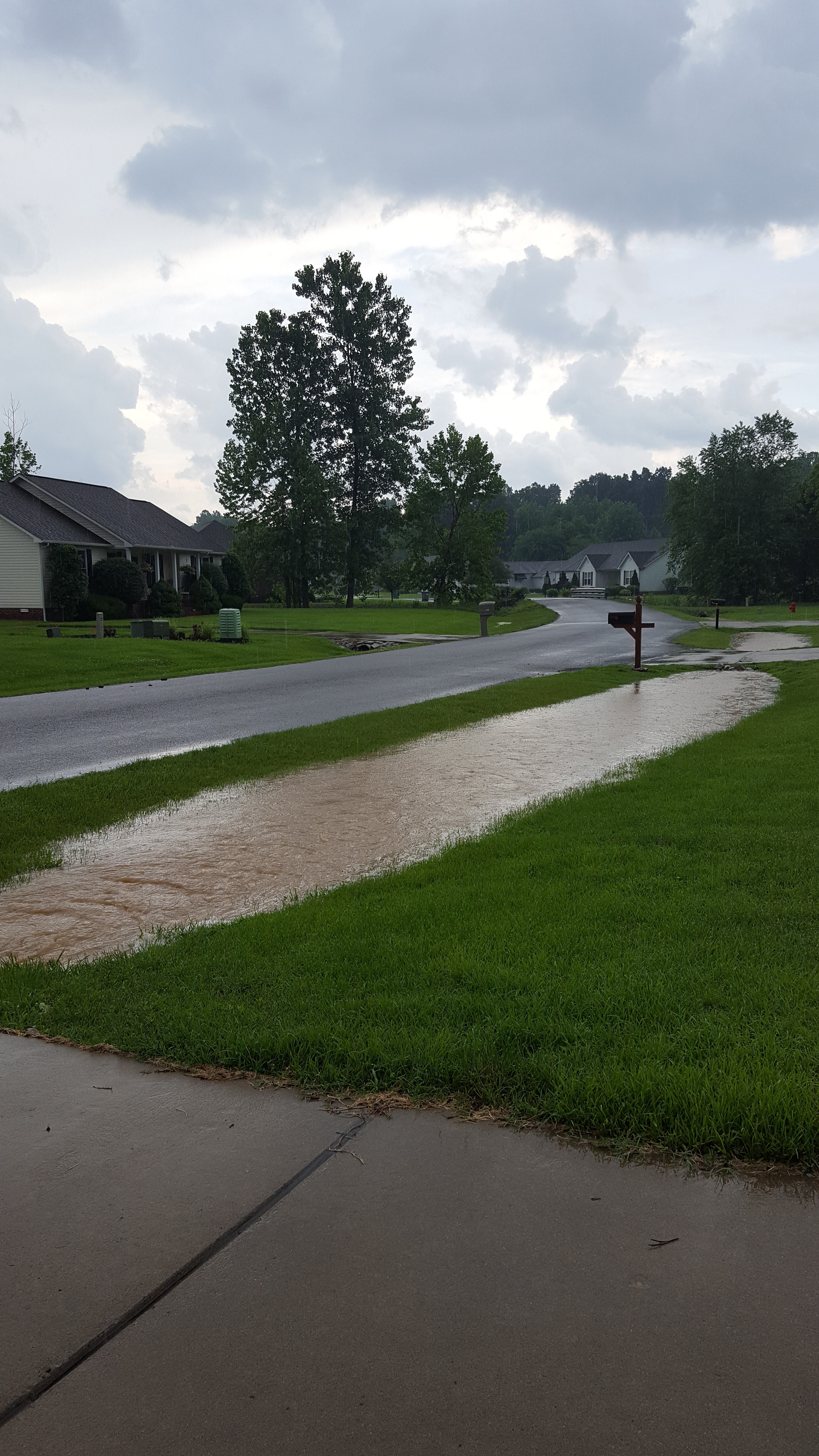 |
| Wind damage in Boonville, IN via Dorothy Annestedt Taylor | Hail in Norris City, ILvia Stephanie Dial Knight | Wind damage in Marion, IL via WSIL | Ditches are full from heavy rain in Lone Oak, KY via NWS Employee |
Radar:
Multiple rounds of thunderstorms impacted the region. The first during the morning/early afternoon hours across portions of southern Illinois, southwest Indiana, and northwest Kentucky. Then scattered storm development began around mid to late afternoon, with coverage increasing again after 7pm and lasting through the late evening hours.
Click here for a radar loop of this event
Storm Reports
PRELIMINARY LOCAL STORM REPORT...SUMMARY NATIONAL WEATHER SERVICE PADUCAH KY 930 PM CDT FRI JUN 1 2018 ..TIME... ...EVENT... ...CITY LOCATION... ...LAT.LON... ..DATE... ....MAG.... ..COUNTY LOCATION..ST.. ...SOURCE.... ..REMARKS.. 0942 AM TSTM WND DMG PINCKNEYVILLE 38.08N 89.38W 05/31/2018 PERRY IL TRAINED SPOTTER MANY TREE LIMBS DOWN. SEVERAL SHINGLES OFF A HOUSE. 0945 AM TSTM WND DMG CAMPBELL HILL 37.93N 89.55W 05/31/2018 JACKSON IL EMERGENCY MNGR TREES ON POWER LINES IN THE NORTHERN AND SOUTHERN PARTS OF JACKSON COUNTY. 0953 AM TSTM WND DMG DU QUOIN 38.00N 89.24W 05/31/2018 PERRY IL EMERGENCY MNGR MULTIPLE TREES/POWER LINES DOWN ACROSS PERRY COUNTY AND POWER OUTAGES REPORTED. 1000 AM TSTM WND DMG SESSER 38.09N 89.05W 05/31/2018 FRANKLIN IL PUBLIC NUMEROUS LIMBS DOWN. GUTTERS BLOWN OFF A HOUSE. POWER OUTAGES. 1005 AM TSTM WND GST WALTONVILLE 38.21N 89.04W 05/31/2018 M40.00 MPH JEFFERSON IL PUBLIC 1013 AM TSTM WND DMG MOUNT VERNON 38.32N 88.91W 05/31/2018 JEFFERSON IL PUBLIC SCATTTERED TREE DAMAGE WITH LIMBS DOWN BETWEEN WOODLAWN AND MT. VERNON. 1015 AM TSTM WND GST 3 E MOUNT VERNON 38.32N 88.86W 05/31/2018 M78.00 MPH JEFFERSON IL NWS EMPLOYEE MEASURED AT MT. VERNON AIPORT. 1020 AM TSTM WND GST BENTON 38.01N 88.92W 05/31/2018 E40.00 MPH FRANKLIN IL TRAINED SPOTTER 1023 AM TSTM WND DMG CHRISTOPHER 37.97N 89.05W 05/31/2018 FRANKLIN IL LAW ENFORCEMENT POWER OUTAGES SCATTERED ACROSS THE COUNTY. INCLUDING CHRISTOPHER AND MULKEYTOWN. ALSO TREE DOWN ON HIGHWAY NEAR ELMWOOD CEMETARY. 1023 AM TSTM WND DMG GALATIA 37.84N 88.61W 05/31/2018 SALINE IL TRAINED SPOTTER TREES AND POWER LINES DOWN ACROSS THE COUNTY. INCLUDING GALATIA AND CARRIER MILLS. 1030 AM TSTM WND DMG 2 NW DALE 38.02N 88.52W 05/31/2018 HAMILTON IL BROADCAST MEDIA TREES DOWN MAKING RT 142 IMPASSABLE NEAR DALE. 1030 AM FLOOD GALATIA 37.84N 88.61W 05/31/2018 SALINE IL LAW ENFORCEMENT FLOOD ALONG HWY 34. 1042 AM TSTM WND DMG CARMI 38.09N 88.17W 05/31/2018 WHITE IL EMERGENCY MNGR TREES AND POWER LINES DOWN. WIND ESTIMATED AT 40 MPH. 1050 AM TSTM WND DMG FAIRFIELD 38.38N 88.37W 05/31/2018 WAYNE IL EMERGENCY MNGR WIND SPEEDS 40-45 MPH WITH GUSTS ABOVE 60 MPH ESTIMATED. TREES AND POWER LINES DOWN ACROSS COUNTY. BLEW DOORS OPEN ON HEALTH DEPT. GENERATORS ARE BEING UTILIZED. 1055 AM TSTM WND DMG CARMI 38.09N 88.17W 05/31/2018 WHITE IL EMERGENCY MNGR SMALL TREES AND POWER LINES DOWN. WIND ESTIMATED AT 40 MPH. 1055 AM TSTM WND DMG CARMI 38.09N 88.17W 05/31/2018 WHITE IL EMERGENCY MNGR SMALL TREES AND POWER LINES DOWN. WIND ESTIMATED AT 40 MPH. 1056 AM TSTM WND GST BELLE PRAIRIE CITY 38.22N 88.55W 05/31/2018 M58.00 MPH HAMILTON IL BROADCAST MEDIA WIND GUST NEAR INTERSTATE 64. 1102 AM TSTM WND DMG ALBION 38.38N 88.06W 05/31/2018 EDWARDS IL 911 CALL CENTER A COUPLE OF SMALL LIMBS DOWN IN THE CITY OF ALBION. 1110 AM TSTM WND DMG MORGANFIELD 37.68N 87.91W 05/31/2018 UNION KY 911 CALL CENTER A TREE WAS REPORTED OVER A ROAD AND ANOTHER LARGE TREE DOWNED IN UNION COUNTY. 1110 AM TSTM WND DMG BROWNS 38.38N 87.98W 05/31/2018 EDWARDS IL TRAINED SPOTTER LARGE TREE DOWN. 1120 AM TSTM WND DMG ALLENDALE 38.53N 87.71W 05/31/2018 WABASH IL PUBLIC TREE FELL ON A HOUSE IN ALLENDALE. 1130 AM TSTM WND DMG HENDERSON 37.84N 87.58W 05/31/2018 HENDERSON KY BROADCAST MEDIA TREE DOWN. 1130 AM TSTM WND DMG PRINCETON 38.36N 87.57W 05/31/2018 GIBSON IN EMERGENCY MNGR TREES AND POWER OUTAGES MAINLY ON THE WEST SIDE OF PRINCETON. TREES ALSO DOWN IN EAST MOUNT CARMEL. 1133 AM TSTM WND DMG EVANSVILLE 37.98N 87.54W 05/31/2018 VANDERBURGH IN TRAINED SPOTTER SEMI TRUCK BLOWN OVER NEAR INTERSTAE 64 AND US HWY 41 INTERSECTION. ALSO NUMEROUS REPORTS OF TREES AND POWER LINES DOWN ACROSS COUNTY. 1135 AM TSTM WND DMG HENDERSON 37.84N 87.58W 05/31/2018 HENDERSON KY EMERGENCY MNGR AT LEAST A HALF DOZEN TREES DOWN AND POWER OUTAGES REPORTED. PEA SIZE HAIL ALSO REPORTED. 1136 AM TSTM WND GST EVANSVILLE 37.98N 87.54W 05/31/2018 E65.00 MPH VANDERBURGH IN TRAINED SPOTTER 1145 AM TSTM WND DMG OAKLAND CITY 38.34N 87.35W 05/31/2018 GIBSON IN EMERGENCY MNGR A HOUSE PORCH COLLAPSED FROM FALLEN TREES. 1145 AM TSTM WND DMG OAKLAND CITY 38.34N 87.35W 05/31/2018 GIBSON IN EMERGENCY MNGR TREES AND POWER LINES DOWN IN OAKLAND CITY WITH SCATTERED AREAS OF TREE LIMBS DOWN ACROSS THE COUNTY. 1145 AM TSTM WND DMG OAKLAND CITY 38.34N 87.35W 05/31/2018 GIBSON IN EMERGENCY MNGR TREES AND POWER LINES DOWN IN OAKLAND CITY WITH SCATTERED WIND DAMAGE ELSEHWERE IN GIBSON CO. 1145 AM TSTM WND DMG BOONVILLE 38.05N 87.27W 05/31/2018 WARRICK IN TRAINED SPOTTER LATE REPORT AND TIME ESTIMATED...LARGE TREE FELL ON HOME NEAR INTERSECTION OF SOUTH 4TH AND OAK. HOME DAMAGED. 1145 AM TSTM WND DMG OAKLAND CITY 38.34N 87.35W 05/31/2018 GIBSON IN EMERGENCY MNGR TREES AND POWER LINES DOWN IN OAKLAND CITY. SCATTERED TREE LIMBS DOWN ELSEWHERE ACROSSS THE COUNTY. 1147 AM TSTM WND DMG CHANDLER 38.04N 87.37W 05/31/2018 WARRICK IN 911 CALL CENTER TREE LIMBS DOWN. 1155 AM HAIL 6 NW HOLLAND 38.31N 87.12W 05/31/2018 E0.25 INCH PIKE IN COCORAHS 1212 PM TSTM WND GST ROCKPORT 37.88N 87.05W 05/31/2018 M59.00 MPH SPENCER IN TRAINED SPOTTER 1245 PM HAIL OWENSBORO 37.76N 87.12W 05/31/2018 E1.00 INCH DAVIESS KY FIRE DEPT/RESCUE REPORTED ALONG THE DAVIESS HANCOCK COUNTY LINE. 0115 PM HAIL BENTON 36.85N 88.36W 05/31/2018 M1.00 INCH MARSHALL KY PUBLIC 0121 PM HAIL BENTON 36.85N 88.36W 05/31/2018 E0.75 INCH MARSHALL KY TRAINED SPOTTER 0201 PM TSTM WND GST NEWBURGH 37.95N 87.40W 05/31/2018 M60.00 MPH WARRICK IN PUBLIC 0253 PM HAIL CAIRO 37.00N 89.18W 05/31/2018 M1.00 INCH ALEXANDER IL BROADCAST MEDIA AT THE CAIRO IL FIRE DEPT. 0253 PM HAIL CAIRO 37.00N 89.18W 05/31/2018 M0.25 INCH ALEXANDER IL BROADCAST MEDIA AT THE CAIRO FIRE DEPT. 0253 PM HAIL CAIRO 37.00N 89.18W 05/31/2018 M1.00 INCH ALEXANDER IL BROADCAST MEDIA AT THE CAIRO IL FIRE DEPT. 0310 PM HEAVY RAIN LONE OAK 37.04N 88.67W 05/31/2018 M0.45 INCH MCCRACKEN KY NWS EMPLOYEE 10 MINUTE ACCUMULATION 0342 PM HAIL KEVIL 37.08N 88.89W 05/31/2018 M0.75 INCH BALLARD KY BROADCAST MEDIA DIME SIZE HAIL REPORTED. 0347 PM TSTM WND GST WEST PADUCAH 37.08N 88.74W 05/31/2018 E55.00 MPH MCCRACKEN KY NWS EMPLOYEE 0352 PM HAIL WEST PADUCAH 37.08N 88.74W 05/31/2018 M1.00 INCH MCCRACKEN KY BROADCAST MEDIA PUBLIC REPORT VIA BROADCAST MEDIA 0400 PM HEAVY RAIN WEST PADUCAH 37.08N 88.74W 05/31/2018 M0.86 INCH MCCRACKEN KY ASOS ONE HOUR MEASUREMENT AT BARKLEY REGIONAL AIRPORT 0400 PM TSTM WND DMG 8 SE LA CENTER 36.99N 88.87W 05/31/2018 BALLARD KY TRAINED SPOTTER NUMEROUS LIMBS DOWN. 0400 PM FLOOD 8 SE LA CENTER 36.99N 88.87W 05/31/2018 BALLARD KY TRAINED SPOTTER WATER ACROSS PHELPS ROAD NEAR THE COMMUNITY OF NEW YORK. 0404 PM HEAVY RAIN WEST PADUCAH 37.08N 88.74W 05/31/2018 M0.66 INCH MCCRACKEN KY ASOS 10 MINUTE ACCUMULATION AT BARKLEY REGIONAL AIRPORT. 0410 PM FLASH FLOOD KEVIL 37.08N 88.89W 05/31/2018 BALLARD KY BROADCAST MEDIA HIGHWAY 60 NEARLY IMPASSABLE WITH NUMEROUS VEHILES IN DITCHES. 0424 PM TSTM WND DMG BOONVILLE 38.05N 87.27W 05/31/2018 WARRICK IN TRAINED SPOTTER LATE REPORT...LARGE TREE FELL ON HOME NEAR INTERSECTION OF SOUTH 4TH AND OAK. HOME DAMAGED. REPORT VIA BROADCAST MEDIA. 0432 PM TSTM WND DMG 3 N HOPKINSVILLE 36.90N 87.49W 05/31/2018 CHRISTIAN KY EMERGENCY MNGR TREES DOWN 0440 PM FLASH FLOOD 3 N HOPKINSVILLE 36.90N 87.49W 05/31/2018 CHRISTIAN KY TRAINED SPOTTER ONE FOOT OF WATER OVER HIGHWAY 41 NEAR OLD KELLY ROAD JUNCTION. 0444 PM HEAVY RAIN WEST PADUCAH 37.08N 88.74W 05/31/2018 M1.74 INCH MCCRACKEN KY NWS EMPLOYEE ONE HOUR RAINFALL ACCUMULATION AT NWS OFFICE IN WEST PADUCAH. 0445 PM TSTM WND DMG 4 NW HOPKINSVILLE 36.90N 87.54W 05/31/2018 CHRISTIAN KY TRAINED SPOTTER ACROSS FROM 3990 PRINCETON ROAD, OR HIGHWAY 91, TREE DOWN AND CORN LAYING FLAT. 0448 PM HEAVY RAIN 6 N HOPKINSVILLE 36.94N 87.49W 05/31/2018 M1.26 INCH CHRISTIAN KY MESONET 40 MINUTE RAINFALL ACCUMULATION 0504 PM FLASH FLOOD HOPKINSVILLE 36.85N 87.49W 05/31/2018 CHRISTIAN KY EMERGENCY MNGR FLASH FLOODING REPORTED IN HAPPY HOLLOW AREA. 0510 PM TSTM WND DMG 10 NE HOPKINSVILLE 36.96N 87.36W 05/31/2018 CHRISTIAN KY EMERGENCY MNGR TREES DOWN ACROSS INTERSECTION OF SHAW OVAL ROAD AND PILOT ROCK ROAD. 0511 PM HAIL VAN BUREN 37.01N 91.01W 05/31/2018 M0.75 INCH CARTER MO LAW ENFORCEMENT DIME SIZE HAIL AND 30 MPH WINDS REPORTED IN THE COMMUNITY. 0520 PM TSTM WND DMG HOPKINSVILLE 36.85N 87.49W 05/31/2018 CHRISTIAN KY EMERGENCY MNGR TREE FELL ACROSS POWER LINES ALONG PARKVIEW ROAD. AREA WITHOUT POWER. TIME ESTIMATED. 0521 PM TSTM WND DMG 3 NE HOPKINSVILLE 36.89N 87.45W 05/31/2018 CHRISTIAN KY EMERGENCY MNGR TREES DOWN BLOCKING ROAD NEAR 4510 N GREENVILLE ROAD. 0522 PM FLASH FLOOD 3 NW HOPKINSVILLE 36.89N 87.53W 05/31/2018 CHRISTIAN KY EMERGENCY MNGR WATER OVER ROAD AND IMPASSABLE NEAR 2675 HAPPY HOLLOW ROAD. 0523 PM HAIL FREEMONT 36.95N 91.15W 05/31/2018 M1.00 INCH CARTER MO FIRE DEPT/RESCUE QUARTER SIZE HAIL REPORTED NEAR INTERSECTION OF HIGHWAY Y AND HIGHWAY 60. 0525 PM HEAVY RAIN HOPKINSVILLE 36.85N 87.49W 05/31/2018 M1.89 INCH CHRISTIAN KY TRAINED SPOTTER 1 HOUR RAINFALL TOTAL. 0533 PM FUNNEL CLOUD ELLSINORE 36.93N 90.75W 05/31/2018 CARTER MO LAW ENFORCEMENT REPORTED BY LAW ENFORCEMENT NORTHWEST OF TOWN 0542 PM FUNNEL CLOUD 5 NW HUNTER 36.94N 90.91W 05/31/2018 CARTER MO TRAINED SPOTTER 0720 PM HAIL CREAL SPRINGS 37.62N 88.84W 05/31/2018 E0.75 INCH WILLIAMSON IL TRAINED SPOTTER 0740 PM FUNNEL CLOUD FRUITLAND 37.45N 89.64W 05/31/2018 CAPE GIRARDEAU MO EMERGENCY MNGR 0743 PM TORNADO 5 NE JACKSON 37.43N 89.59W 05/31/2018 CAPE GIRARDEAU MO TRAINED SPOTTER UNCONFIRMED...REPORTED NORTHEAST OF JACKSON MOVING ACROSS THE MISSISSIPPI RIVER. 0744 PM TORNADO 5 E FRUITLAND 37.45N 89.55W 05/31/2018 CAPE GIRARDEAU MO NWS STORM SURVEY AN EF-1 TORNADO WITH PEAK WINDS OF 90 MPH TOUCHED DOWN 5 MILES EAST OF FRUITLAND AND LIFTED 8 MILES EAST OF FRUITLAND NEAR TRAIL OF TEARS STATE PARK. PATH LENGTH WAS 2.5 MILES WITH A MAXIMUM WIDTH OF 150 YARDS. DOZENS OF TREES, SOME LARGE, WERE BROKEN OR UPROOTED. SEVERAL POWER POLES WERE SNAPPED FROM FALLEN TREES. 0750 PM FUNNEL CLOUD 7 NE FRUITLAND 37.52N 89.55W 05/31/2018 CAPE GIRARDEAU MO EMERGENCY MNGR MULTIPLE REPORTS OF FUNNEL CLOUD NEAR PROCTOR AND GAMBLE PLANT. 0750 PM TORNADO 5 NW WARE 37.50N 89.46W 05/31/2018 UNION IL TRAINED SPOTTER UNCONFIRMED...REPORTED JUST EAST OF THE MISSISSIPPI RIVER. 0754 PM TORNADO 1 S WOLF LAKE 37.49N 89.47W 05/31/2018 UNION IL NWS STORM SURVEY AN EF-1 TORNADO WITH PEAK WINDS UP TO 95 MPH TOUCHED DOWN 2.5 MILES SOUTHWEST OF WOLF LAKE AND LIFTED 1 MILE EAST OF WOLF LAKE. PATH LENGTH WAS 3.5 MILES WITH A MAXIMUM WIDTH OF 150 YARDS. A VERY LARGE EQUIPMENT BARN COLLAPSED AND ANOTHER BARN WAS DESTROYED. A ONE STORY HOUSE WAS PARTIALLY SHIFTED OFF ITS FOUNDATION. ALL STRUCTURAL DAMAGE WAS ALONG THE WARE WOLF LAKE ROAD. 0755 PM TORNADO 2 S WOLF LAKE 37.47N 89.47W 05/31/2018 UNION IL NWS STORM SURVEY AN EF-0 TORNADO WITH PEAK WINDS OF 75 MPH TOUCHED DOWN 3 MILE SOUTHWEST OF WOLF LAKE AND LIFTED 2 MILES SOUTH OF WOLF LAKE. PATH LENGTH WAS 1.25 MILES WITH A MAXIMUM WIDTH OF 50 YARDS. SEVERAL TREE LIMBS, MOSTLY SMALL, WERE BROKEN. THE ROOF OF A BARN WAS BLOWN IN ON ONE SIDE. 0755 PM HAIL 5 SW NORRIS CITY 37.93N 88.39W 05/31/2018 M1.25 INCH HAMILTON IL TRAINED SPOTTER REPORTED IN THE COMMUNITY OF GOSSEETT. 0756 PM TORNADO 5 SW WARE 37.40N 89.46W 05/31/2018 CAPE GIRARDEAU MO TRAINED SPOTTER TORNADO...RECORDED VIDEO OF THE EVENT. 0801 PM HAIL NORRIS CITY 37.98N 88.33W 05/31/2018 M1.50 INCH WHITE IL PUBLIC PING PONG SIZE HAIL. 0804 PM HAIL 3 NW OMAHA 37.92N 88.34W 05/31/2018 M1.00 INCH WHITE IL TRAINED SPOTTER QUARTER SIZE HAIL REPORTED. 0849 PM HAIL 2 N DU QUOIN 38.03N 89.24W 05/31/2018 M0.75 INCH PERRY IL EMERGENCY MNGR 0855 PM FLOOD 1 WNW OWENSBORO 37.76N 87.14W 05/31/2018 DAVIESS KY TRAINED SPOTTER 0922 PM TSTM WND DMG 5 NE ADVANCE 37.15N 89.85W 05/31/2018 CAPE GIRARDEAU MO LAW ENFORCEMENT LATE REPORT...TREES AND POWER LINES DOWN ALONG HIGHWAY 274 0931 PM HAIL WILLIAMSVILLE 36.97N 90.55W 05/31/2018 M0.75 INCH WAYNE MO PUBLIC 0935 PM TSTM WND DMG BENTON 37.10N 89.56W 05/31/2018 SCOTT MO PUBLIC TREES DOWN AND POWER OUTAGES 0936 PM HAIL 2 E DU QUOIN 38.00N 89.20W 05/31/2018 M0.75 INCH PERRY IL EMERGENCY MNGR 0937 PM HAIL 10 N POPLAR BLUFF 36.91N 90.41W 05/31/2018 M0.75 INCH BUTLER MO TRAINED SPOTTER NEAR THE COUNTY LINE 0945 PM TSTM WND GST 1 N DELTA 37.21N 89.74W 05/31/2018 E50.00 MPH CAPE GIRARDEAU MO TRAINED SPOTTER 0950 PM TSTM WND DMG 2 N BLODGETT 37.03N 89.53W 05/31/2018 SCOTT MO PUBLIC TREE BLOWN OVER ROAD ON HIGHWAY H NEAR COUNTY ROAD 506. NUMEROUS POWER OUTAGES ALSO REPORTED WITHIN THE COUNTY AS STORMS ROLLED THROUGH. 0951 PM TSTM WND DMG SW WAPPAPELLO 36.94N 90.27W 05/31/2018 WAYNE MO LAW ENFORCEMENT TREE AND VEHICLE DAMAGE REPORTED NEAR INTERSECTION OF HWY T AND RA. SMALL HAIL ALSO REPORTED. 1015 PM TSTM WND DMG SIKESTON 36.88N 89.58W 05/31/2018 SCOTT MO PUBLIC TREE BLOWN ONTO HOUSE ON LEE STREET. ADDITIONAL TREES BLOWN DOWN IN TOWN AND POWER LINES DOWN IN TOWN. SOME POWER OUTAGES AND NUMEROUS TREE LIMBS DOWN. 1028 PM TSTM WND DMG OSCAR 37.14N 89.03W 05/31/2018 BALLARD KY PUBLIC DAMAGING WINDS WITH POWER OUTAGES REPORTED IN THE COMMUNITY. 1032 PM TSTM WND DMG EAST PRAIRIE 36.78N 89.38W 05/31/2018 MISSISSIPPI MO TRAINED SPOTTER NUMEROUS TREE LIMBS DOWN. 2 TO 3 INCH DIAMETER. 1200 AM FLOOD MACEDONIA 38.05N 88.70W 06/01/2018 HAMILTON IL EMERGENCY MNGR REPORT OF HIGH WATER OVER THE ROADWAY ON STATE HWY 14 AT THE VIADUCT IN MACEDONIA. 1220 AM FLOOD EVANSVILLE 37.98N 87.54W 06/01/2018 VANDERBURGH IN TRAINED SPOTTER FLOODING ON HWY 62 NEAR VETERANS MEMORIAL PARKWAY. 4 TO 6 INCHES OF STANDING WATER ON THE ROAD. 0210 AM FLASH FLOOD CHRISNEY 38.01N 87.03W 06/01/2018 SPENCER IN LAW ENFORCEMENT MULTIPLE VEHICLE WATER RESCUSES REPORTED. WATER COVERED ROADS AND HIGHWAYS INCLUDE 70, 62 NEAR 75 WEST, COUNTY ROAD 1400 NORTH, AND 1600 NORTH JUST EAST OF SANTA CLAUS. 0930 AM HEAVY RAIN EVANSVILLE 37.98N 87.54W 06/01/2018 M3.20 INCH VANDERBURGH IN PUBLIC 24 HOUR RAINFALL ACCUMULATION REPORTED IN THE ANGEL MOUNDS AREA.
 |
Media use of NWS Web News Stories is encouraged! Please acknowledge the NWS as the source of any news information accessed from this site. |
|

