Overview
During the late afternoon and evening hours on Friday, July 8, clusters of severe thunderstorms moved through portions of the region. The worst of the storms occurred across southern Illinois into western Kentucky, where scattered wind damage occurred to trees, powerlines, and outbuildings. Isolated wind damage and hail also occurred near Evansville, IN, and East Prairie, MO. Locally heavy rain of 3 to 5 inches fell near the Madisonville, KY, area in Hopkins County. Beneficial rainfall of 1 to 3 inches also fell across much of western Kentucky into southwest Indiana.Photos & Video
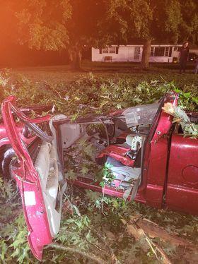
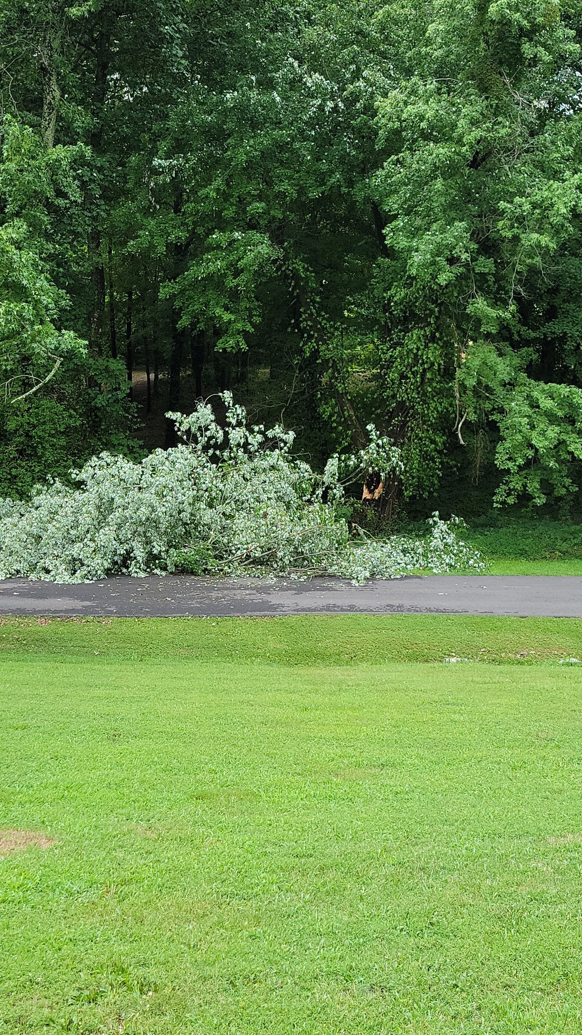
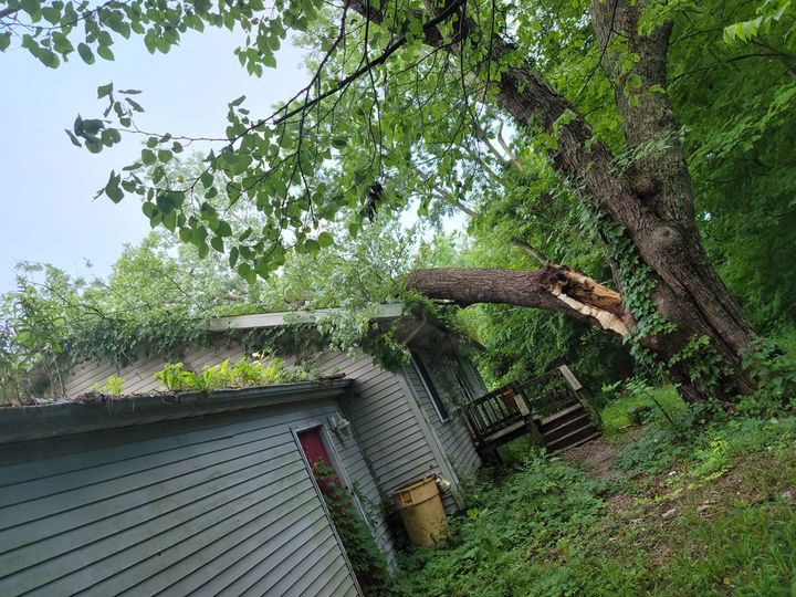
The great majority of the wind damage was from snapped trees and downed tree limbs.
 |
 |
 |
 |
| Tree fell on a vehicle near Buncombe in Johnson County, IL (WSIL-TV) | Tree snapped in Central City, KY (Carlos Tatum) |
Tree limb on house in Gorham, IL (Kim Arena) |
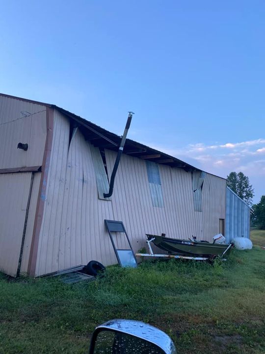
Wall bowed in on a workshop in Clinton, KY. (Allison Kelly) |
Storm Reports
0230 PM     TSTM WND DMG     BREMEN                  37.36N 87.22W
07/08/2022                   MUHLENBERG         KY   PUBLIC

            TREE DAMAGE TO A GARAGE. TIME ESTIMATED.

0235 PM     TSTM WND DMG     3 N CALVERT CITY        37.07N 88.35W
07/08/2022                   LIVINGSTON         KY   EMERGENCY MNGR

            SEVERAL TREE TOPS BROKEN OFF ALONG HADDOX
            FERRY ROAD SOUTH OF HWY 453.

0450 PM     TSTM WND GST     3 NE TRENTON            36.76N 87.22W
07/08/2022  M55 MPH          TODD               KY   MESONET

            OBSERVED WIND GUST AT TODD COUNTY MESONET
            STATION 5 MILES SOUTHWEST OF ELKTON.

0625 PM     TSTM WND DMG     GORHAM                  37.72N 89.49W
07/08/2022                   JACKSON            IL   PUBLIC

            THUNDERSTORM OUTFLOW WINDS SNAPPED A TREE
            WHICH FELL INTO A HOME IN GORHAM CAUSING
            STRUCTURAL DAMAGE.

0640 PM     TSTM WND GST     3 SSW DE SOTO           37.78N 89.25W
07/08/2022  M48 MPH          JACKSON            IL   ASOS

            MEASURED AT THE CARBONDALE ASOS STATION
            LOCATED AT THE SOUTHERN ILLINOIS AIRPORT.

0645 PM     TSTM WND GST     DE SOTO                 37.81N 89.22W
07/08/2022  E60 MPH          JACKSON            IL   TRAINED SPOTTER

            50 TO 60 MPH WIND GUSTS. MULTIPLE SMALL
            BRANCHES 1 TO 3 INCH IN DIAMETER DOWN.

0650 PM     TSTM WND DMG     ROYALTON                37.88N 89.11W
07/08/2022                   FRANKLIN           IL   BROADCAST MEDIA

            LARGE TREE CAME DOWN ON POWER LINE. SEVERAL
            LIMBS DOWN THROUGHOUT TOWN.

0705 PM     TSTM WND DMG     DE SOTO                 37.81N 89.23W
07/08/2022                   JACKSON            IL   PUBLIC

            50-60 MPH WINDS (VISUALLY) CONFIRMED SOUTH
            OF DE SOTO, MULTIPLE SMALL (1-3 INCH)
            BRANCHES DOWN IN YARD. REPORT RELAYED VIA TWITTER.
0745 PM     TSTM WND DMG     3 SW MCLEANSBORO        38.07N 88.57W
07/08/2022                   HAMILTON           IL   EMERGENCY MNGR

            LATE REPORT. NUMEROUS TREES WERE BLOWN DOWN
            ACROSS THE SOUTHERN PART OF HAMILTON COUNTY.
            SOME OF THE MOST CONCENTRATED DAMAGE WAS
            LOCATED SOUTHWEST OF MCLEANSBORO NEAR THE
            INTERSECTION OF ANDERSON SCHOOL ROAD AND
            COUNTY ROAD 1100N. A CARPORT WAS LIFTED AND
            BLOWN A FEW HUNDRED FEET.


0810 PM     HAIL             2 NE DARMSTADT          38.11N 87.56W
07/08/2022  E1.50 INCH       VANDERBURGH        IN   PUBLIC

            PUBLIC REPORT OF 1.25 TO 1.5 INCH HAIL NEAR
            DARMSTADT. TIME ESTIMATED FROM RADAR.

0858 PM     FUNNEL CLOUD     3 NNW NEWBURGH          37.99N 87.41W
07/08/2022                   WARRICK            IN   PUBLIC

            FUNNEL CLOUD OBSEVERED 7 MILES EAST OF
            EVANSVILLE. NOT TOUCHING DOWN AT THIS TIME.
            CORRECTED LOCATION FROM PREVIOUS LSR.

0858 PM     FUNNEL CLOUD     NEWBURGH                37.94N 87.41W
07/08/2022                   WARRICK            IN   PUBLIC

            LATE REPORT.

0950 PM     TSTM WND DMG     4 NW BLANDVILLE         36.98N 89.01W
07/08/2022                   BALLARD            KY   PUBLIC

            LARGE TREE LIMBS DOWN AND A LARGE TREE WAS
            UPROOTED. TIME ESTIMATED FROM RADAR.

0957 PM     TSTM WND DMG     EAST PRAIRIE            36.78N 89.38W
07/08/2022                   MISSISSIPPI        MO   PUBLIC

            SCATTERED 4 INCH LIMB DOWNED AROUND TOWN
            ALONG WITH SOME POWER OUTAGES. TIME
            ESTIMATED FROM RADAR.

1006 PM     TSTM WND DMG     RUMSEY                  37.53N 87.26W
07/08/2022                   MCLEAN             KY   PUBLIC

            TREE UPROOTED.

1012 PM     TSTM WND DMG     BUNCOMBE                37.47N 88.97W
07/08/2022                   JOHNSON            IL   PUBLIC

            NUMEROUS TREES SNAPPED AND LARGE LIMBS
            DOWNED. WINDS WERE ESTIMATED TO BE GREATER
            THAN 60 MPH. TIME ESTIMATED FROM RADAR.

1019 PM     TSTM WND DMG     1 WSW PADUCAH           37.07N 88.65W
07/08/2022                   MCCRACKEN          KY   PUBLIC

            LARGE TREE SNAPPED OFF BROOKFIELD DRIVE IN
            PADUCAH. TIME ESTIMATED.

1019 PM     TSTM WND DMG     1 NNW PADUCAH           37.08N 88.64W
07/08/2022                   MCCRACKEN          KY   NWS EMPLOYEE

            LARGE TREE SNAPPED BY THE BALL FIELDS IN
            NOBLE PARK. TIME ESTIMATED FROM RADAR.

1022 PM     TSTM WND DMG     CUNNINGHAM              36.91N 88.89W
07/08/2022                   CARLISLE           KY   PUBLIC

            LARGE TREE SNAPPED. TIME ESTIMATED FROM
            RADAR.

1030 PM     TSTM WND DMG     1 WNW HAMLETSBURG       37.15N 88.46W
07/08/2022                   POPE               IL   PUBLIC

            ROWS ON CORN BLOWN DOWN. TIME ESTIMATED FROM
            RADAR.

1040 PM     TSTM WND DMG     3 SW BUNCOMBE           37.44N 89.02W
07/08/2022                   JOHNSON            IL   LAW ENFORCEMENT

            *** 1 INJ ***
            AT LEAST ONE PERSON WAS HURT AFTER A TREE
            FELL ONTO THEIR VEHICLE WHILE DRIVING,
            ACCORDING TO ILLINOIS STATE POLICE. ISP SAYS
            IT HAPPENED ON ROUTE 146 JUST EAST OF MT.
            PISGAH ROAD AROUND 10:40 P.M. FRIDAY. THE
            TRUCK WAS HEADING WEST ON ROUTE 146 WHEN A
            LARGE TREE FELL ONTO THE VEHICLE, ACCORDING
            TO ISP. TWO OCCUPANTS WERE INSIDE THE
            VEHICLE BUT ONLY ONE WAS TAKEN TO A HOSPITAL
            FOR TREATMENT. REPORT RELAYED BY WSIL-TV.

1155 PM     TSTM WND DMG     3 E FANCY FARM          36.76N 88.74W
07/08/2022                   GRAVES             KY   PUBLIC

            TREES DOWN AND CORN FLATTENED. TIME
            ESTIMATED BY RADAR.

1201 AM     TSTM WND DMG     CLINTON                 36.67N 88.99W
07/09/2022                   HICKMAN            KY   PUBLIC

            WALL BOWED IN ON A METAL WORKSHOP. TIME
            ESTIMATED FROM RADAR.

1204 AM     TSTM WND DMG     3 NE FULTON             36.54N 88.84W
07/09/2022                   HICKMAN            KY   PUBLIC

            TREE LIMB DOWN AND CORN FLATTENED. TIME
            ESTIMATED FROM RADAR.

1215 AM     TSTM WND GST     3 ESE KIRKSEY           36.67N 88.37W
07/09/2022  M48 MPH          CALLOWAY           KY   AWOS

            CORRECTS PREVIOUS NON-TSTM WND GST REPORT
            FROM 3 ESE KIRKSEY. AWOS STATION KCEY MURRAY
            KY.

1215 AM     TSTM WND GST     4 ENE MAYFIELD          36.77N 88.58W
07/09/2022  M53 MPH          GRAVES             KY   AWOS

            CORRECTS PREVIOUS NON-TSTM WND GST REPORT
            FROM 4 ENE MAYFIELD. AWOS STATION KM25
            MAYFIELD KY.

1225 AM     TSTM WND DMG     MURRAY                  36.61N 88.32W
07/09/2022                   CALLOWAY           KY   UTILITY COMPANY

            1300 CUSTOMERS WITHOUT POWER IN CALLOWAY
            COUNTY. ALSO NUMEROUS TREES DOWN.

1229 AM     FLOOD            EARLINGTON              37.28N 87.51W
07/09/2022                   HOPKINS            KY   PUBLIC

            FLOODING UP TO BACK PORCH IN GARAGE OF HOME.
            SIX TO EIGHT INCHES OF WATER UP TO FRONT
            PORCH STEP. THE HOUSE WAS LOCATED ON A HILL.
            REPORT RELAYED THROUGH FACEBOOK.
Rain Reports
...24 HOUR RAINFALL REPORTS ENDING AT 2 PM SATURDAY, JULY 9TH...

LOCATION                     AMOUNT    TIME/DATE       PROVIDER

...ILLINOIS...

...ALEXANDER COUNTY...
CAIRO                        0.21 IN   0700 AM 07/09   COCORAHS
BEAN RIDGE                   0.20 IN   1257 PM 07/09   RAWS
0.9 SE COMMERCE              0.13 IN   0130 PM 07/09   HADS
0.9 NW THEBES                0.08 IN   0130 PM 07/09   HADS

...EDWARDS COUNTY...
ALBION 1.4 E                 0.72 IN   0700 AM 07/09   COCORAHS
ALBION                       0.68 IN   0700 AM 07/09   COCORAHS

...FRANKLIN COUNTY...
CHRISTOPHER 1.1 NNW          0.67 IN   0700 AM 07/09   COCORAHS
WEST FRANKFORT               0.23 IN   0130 PM 07/09   CWOP
BENTON 1 N   E               0.05 IN   0705 AM 07/09   COCORAHS
3 N WEST CITY                0.04 IN   0100 PM 07/09   HADS

...GALLATIN COUNTY...
6 S JUNCTION                 0.47 IN   0145 PM 07/09   AWS

...HAMILTON COUNTY...
MCLEANSBORO 4.9 W            0.37 IN   0600 AM 07/09   COCORAHS
MCLEANSBORO 0.6 N            0.36 IN   0700 AM 07/09   COCORAHS
NORRIS CITY 7 NW             0.29 IN   0830 AM 07/09   COCORAHS

...HARDIN COUNTY...
ROSICLARE 5 NW               0.59 IN   0700 AM 07/09   COOP
1 NE ELIZABETHTOWN           0.46 IN   0145 PM 07/09   AWS
HEROD 4.4 E                  0.25 IN   0700 AM 07/09   COCORAHS

...JACKSON COUNTY...
1 NW CAMPBELL HILL           0.71 IN   0145 PM 07/09   AWS
DE SOTO 0.3 ESE              0.45 IN   0700 AM 07/09   COCORAHS
MURPHYSBORO 2.8 NNE          0.12 IN   0700 AM 07/09   COCORAHS
CARBONDALE                   0.09 IN   0105 PM 07/09   ASOS
GRAND TOWER                  0.09 IN   0130 PM 07/09   HADS
1 E CARBONDALE               0.08 IN   0145 PM 07/09   AWS
MURPHYSBORO 1 NW             0.04 IN   0700 AM 07/09   COCORAHS
CARBONDALE 1.2 W             0.03 IN   0700 AM 07/09   COCORAHS
CARBONDALE 2.5 W             0.03 IN   0700 AM 07/09   COCORAHS
CARBONDALE 0.7 W             0.02 IN   0758 AM 07/09   COCORAHS

...JEFFERSON COUNTY...
DIX 2 ENE                    0.67 IN   0706 AM 07/09   COCORAHS
DIX                          0.52 IN   0130 PM 07/09   CWOP
MOUNT VERNON 5.2 SSW         0.22 IN   0800 AM 07/09   COCORAHS
ASHLEY                       0.22 IN   0130 PM 07/09   CWOP
MOUNT VERNON                 0.11 IN   1256 PM 07/09   AWOS
2.8 N WALTONVILLE            0.11 IN   0100 PM 07/09   HADS
3.1 SE WOODLAWN              0.10 IN   0100 PM 07/09   HADS
BELLE RIVE 1 NNE             0.08 IN   1124 AM 07/09   COCORAHS
SCHELLER                     0.03 IN   0128 PM 07/09   CWOP

...JOHNSON COUNTY...
GOREVILLE 3.8 NE             0.12 IN   0700 AM 07/09   COCORAHS
NEW BURNSIDE 1.8 ENE         0.05 IN   0700 AM 07/09   COCORAHS

...MASSAC COUNTY...
METROPOLIS 2 ENE             1.55 IN   0700 AM 07/09   COCORAHS
ROUND KNOB 1 WNW             1.48 IN   0700 AM 07/09   COCORAHS
METROPOLIS                   1.20 IN   0115 PM 07/09   AWOS
BROOKPORT 7 ENE              0.85 IN   0700 AM 07/09   COCORAHS

...PERRY COUNTY...
PINCKNEYVILLE 2 N            0.30 IN   0700 AM 07/09   COOP
PINCKNEYVILLE                0.13 IN   0144 PM 07/09   AWS

...POPE COUNTY...
DIXON SPRINGS                0.44 IN   1255 PM 07/09   ISWS

...PULASKI COUNTY...
NEW GRAND CHAIN 1.1 NE       0.95 IN   0700 AM 07/09   COCORAHS

...SALINE COUNTY...
HARRISBURG 4.6 NNE           0.26 IN   0600 AM 07/09   COCORAHS

...UNION COUNTY...
DONGOLA                      0.36 IN   0145 PM 07/09   AWS
COBDEN 0.8 SSE               0.13 IN   0700 AM 07/09   COCORAHS
COBDEN 4 ENE                 0.08 IN   0700 AM 07/09   COCORAHS
COBDEN 4.2 N                 0.04 IN   0700 AM 07/09   COCORAHS

...WABASH COUNTY...
MOUNT CARMEL                 0.32 IN   0144 PM 07/09   AWS
MOUNT CARMEL 4.2 NW          0.18 IN   0800 AM 07/09   COCORAHS
MOUNT CARMEL 0.9 NNE         TRACE     0730 AM 07/09   COCORAHS

...WAYNE COUNTY...
1 N WAYNE CITY               0.10 IN   0100 PM 07/09   HADS
FAIRFIELD                    0.01 IN   0115 PM 07/09   AWOS

...WHITE COUNTY...
1 N CARMI                    0.29 IN   1230 PM 07/09   HADS
CROSSVILLE 3 E               0.25 IN   0700 AM 07/09   COCORAHS

...WILLIAMSON COUNTY...
CRAB ORCHARD                 0.04 IN   1255 PM 07/09   RAWS
MARION                       0.03 IN   1245 PM 07/09   AWOS
5 SW MARION                  0.03 IN   1255 PM 07/09   HADS
CREAL SPRINGS 2.2 W          TRACE     0700 AM 07/09   COCORAHS
MARION IL 8 SSW              TRACE     0700 AM 07/09   COCORAHS

...INDIANA...

...GIBSON COUNTY...
PRINCETON 0.1 W              0.58 IN   0800 AM 07/09   COCORAHS
FRANCISCO 0.1 SE             0.48 IN   0700 AM 07/09   COCORAHS
OAKLAND CITY                 0.07 IN   0127 PM 07/09   CWOP
0.5 W HAZLETON               0.06 IN   1200 PM 07/09   HADS

...PIKE COUNTY...
PETERSBURG 1 ENE             1.22 IN   0450 AM 07/09   COCORAHS
STENDAL                      1.11 IN   0600 AM 07/09   COOP
HOLLAND 6.3 NW               1.11 IN   0600 AM 07/09   COCORAHS

...POSEY COUNTY...
3.3 NW UNIONTOWN             1.50 IN   0600 AM 07/09   COOP
POSEYVILLE 2.8 NW            1.02 IN   0700 AM 07/09   COCORAHS
MOUNT VERNON                 0.86 IN   0600 AM 07/09   COOP
POSEYVILLE 2.9 SSE           0.83 IN   0700 AM 07/09   COCORAHS
MOUNT VERNON 11.0 ENE        0.50 IN   0700 AM 07/09   COCORAHS
8 W EVANSVILLE               0.49 IN   0500 AM 07/09   COCORAHS
MOUNT VERNON 10.6 ENE        0.49 IN   0700 AM 07/09   COCORAHS
7 E MOUNT VERNON             0.35 IN   0145 PM 07/09   AWS
WADESVILLE                   0.24 IN   0129 PM 07/09   CWOP
NEW HARMONY 1.5 E            0.08 IN   0700 AM 07/09   COCORAHS

...SPENCER COUNTY...
ROCKPORT 4.0 WNW             0.40 IN   0700 AM 07/09   COCORAHS

...VANDERBURGH COUNTY...
EVANSVILLE 6.7 NW            1.23 IN   0700 AM 07/09   COCORAHS
EVANSVILLE 10 NW             0.79 IN   0700 AM 07/09   COCORAHS
MELODY HILL 2.5 NNW          0.64 IN   0927 AM 07/09   COCORAHS
EVANSVILLE 5.4 NNE           0.50 IN   0700 AM 07/09   COCORAHS
EVANSVILLE                   0.47 IN   0101 PM 07/09   ASOS
EVANSVILLE 8.8 WSW           0.43 IN   0545 AM 07/09   COCORAHS
EVANSVILLE 5.9 WNW           0.12 IN   0700 AM 07/09   COCORAHS

...WARRICK COUNTY...
BOONVILLE 4.5 WSW            1.28 IN   0700 AM 07/09   COCORAHS
NEWBURGH 0.3 SE              0.57 IN   0700 AM 07/09   COCORAHS
NEWBURGH                     0.49 IN   0127 PM 07/09   CWOP
NEWBURGH 2.2 NW              0.38 IN   0700 AM 07/09   COCORAHS
NEWBURGH 1 ENE               0.37 IN   0700 AM 07/09   COCORAHS
1.4 N NEWBURGH               0.32 IN   0100 PM 07/09   COOP

...KENTUCKY...

...BALLARD COUNTY...
BANDANA                      1.33 IN   0157 PM 07/09   MESONET
KEVIL 4.6 NW                 1.32 IN   0700 AM 07/09   COCORAHS
WICKLIFFE                    0.75 IN   0126 PM 07/09   CWOP
GAGE                         0.27 IN   0127 PM 07/09   CWOP
1.4 E OLMSTED                0.10 IN   0100 PM 07/09   UCOOP

...CALDWELL COUNTY...
2 SE PRINCETON               1.71 IN   0153 PM 07/09   MESONET
4.3 W CERULEAN               0.23 IN   1230 PM 07/09   HADS

...CALLOWAY COUNTY...
MURRAY                       1.47 IN   0126 PM 07/09   CWOP
1 W MURRAY                   1.08 IN   0156 PM 07/09   MESONET
MURRAY 1 WSW                 0.89 IN   0700 AM 07/09   COCORAHS
NEW CONCORD                  0.66 IN   0130 PM 07/09   CWOP
1.6 SE MURRAY                0.48 IN   0100 PM 07/09   HADS

...CHRISTIAN COUNTY...
CROFTON 0.3 W                1.85 IN   0600 AM 07/09   COCORAHS
6 N HOPKINSVILLE             1.69 IN   0152 PM 07/09   MESONET
OAK GROVE 4.6 NW             1.45 IN   0700 AM 07/09   COCORAHS
FORT CAMPBELL                1.42 IN   1256 PM 07/09   AWOS
HERNDON 4 SW                 1.32 IN   0700 AM 07/09   COOP
CROFTON 3 N                  1.30 IN   0700 AM 07/09   COOP
PRINCETON                    1.28 IN   0116 PM 07/09   CWOP
5.2 N PEMBROKE               1.16 IN   1230 PM 07/09   HADS
HERNDON                      1.13 IN   0115 PM 07/09   CWOP
HOPKINSVILLE 0.3 NW          1.03 IN   0700 AM 07/09   COCORAHS
4 ESE HERNDON                0.99 IN   0140 PM 07/09   AWS
3.4 E HOPKINSVILLE           0.75 IN   1230 PM 07/09   HADS
1.8 NE HOPKINSVILLE          0.43 IN   1230 PM 07/09   HADS

...CRITTENDEN COUNTY...
MARION 6.3 NW                1.11 IN   0700 AM 07/09   COCORAHS
4 NE MARION                  0.92 IN   0155 PM 07/09   MESONET

...DAVIESS COUNTY...
UTICA                        0.97 IN   0600 AM 07/09   COCORAHS
OWENSBORO 4.9 S              0.95 IN   0700 AM 07/09   COCORAHS
MASONVILLE 0.8 ENE           0.74 IN   0853 AM 07/09   COCORAHS
OWENSBORO 3.4 WNW            0.62 IN   0600 AM 07/09   COCORAHS
OWENSBORO 1.7 SSW            0.62 IN   0700 AM 07/09   COCORAHS
HAWESVILLE 9.5 SW            0.58 IN   0900 AM 07/09   COCORAHS
OWENSBORO 1.4 NNW            0.57 IN   0700 AM 07/09   COCORAHS
OWENSBORO 5.9 W              0.52 IN   0700 AM 07/09   COCORAHS
UTICA 5.4 ESE                0.49 IN   0630 AM 07/09   COCORAHS
OWENSBORO 4.1 W              0.46 IN   0658 AM 07/09   COCORAHS
CALHOUN 6.2 N                0.42 IN   0700 AM 07/09   COCORAHS
OWENSBORO 3.5 ESE            0.33 IN   0700 AM 07/09   COCORAHS
OWENSBORO 4.0 E              0.28 IN   0620 AM 07/09   COCORAHS
PHILPOT 2.0 S                0.24 IN   0700 AM 07/09   COCORAHS
OWENSBORO 4.3 E              0.23 IN   0737 AM 07/09   COCORAHS
LEWISPORT                    0.20 IN   0129 PM 07/09   CWOP
OWENSBORO                    0.12 IN   1256 PM 07/09   AWOS
WHITESVILLE                  0.08 IN   0145 PM 07/09   AWS

...FULTON COUNTY...
2 E HICKMAN                  2.06 IN   0156 PM 07/09   MESONET
FULTON 5.0 W                 2.02 IN   0600 AM 07/09   COCORAHS

...GRAVES COUNTY...
FARMINGTON 5.6 S             0.97 IN   0700 AM 07/09   COCORAHS
2 NNE WINGO                  0.59 IN   0156 PM 07/09   MESONET
MAYFIELD                     0.38 IN   0115 PM 07/09   AWOS

...HENDERSON COUNTY...
HENDERSON 8 SSW              2.51 IN   0700 AM 07/09   COOP
HENDERSON 5.1 SSW            1.98 IN   0700 AM 07/09   COCORAHS
4 WSW SPOTTSVILLE            1.27 IN   0154 PM 07/09   MESONET
HENDERSON KY 0.4 SSW         1.10 IN   0700 AM 07/09   COCORAHS
0.7 NW HENDERSON             0.92 IN   1245 PM 07/09   HADS
HENDERSON                    0.41 IN   1256 PM 07/09   AWOS

...HICKMAN COUNTY...
FULTON 3.3 NE                1.10 IN   0730 AM 07/09   COCORAHS

...HOPKINS COUNTY...
1 ENE EARLINGTON             4.83 IN   0137 PM 07/09   MESONET
MADISONVILLE                 3.63 IN   0128 PM 07/09   CWOP
MADISONVILLE                 3.36 IN   0115 PM 07/09   AWOS

...LIVINGSTON COUNTY...
SMITHLAND LOCK AND DAM       0.50 IN   0600 AM 07/09   COOP
1.9 W GRAND RIVERS           0.43 IN   0130 PM 07/09   COOP
0.9 S GOLCONDA               0.42 IN   0100 PM 07/09   HADS

...LYON COUNTY...
EDDYVILLE 2 NNE              0.80 IN   0716 AM 07/09   COCORAHS
KUTTAWA 3.4 NW               0.74 IN   0548 AM 07/09   COCORAHS

...MARSHALL COUNTY...
CALVERT CITY 2.5 SSW         1.32 IN   0800 AM 07/09   COCORAHS
GRAND RIVERS 3.9 S           1.21 IN   0700 AM 07/09   COCORAHS
3 W FAIRDEALING              0.85 IN   0130 PM 07/09   HADS
MURRAY                       0.84 IN   0128 PM 07/09   CWOP
4 N BENTON                   0.80 IN   0155 PM 07/09   MESONET

...MCCRACKEN COUNTY...
PADUCAH 1 NNE                1.62 IN   0700 AM 07/09   COCORAHS
PADUCAH 4.5 SW               1.38 IN   0800 AM 07/09   COCORAHS
WEST PADUCAH 3.1 SSW         1.01 IN   0900 AM 07/09   COCORAHS
PADUCAH                      0.80 IN   1253 PM 07/09   ASOS
WEST PADUCAH                 0.70 IN   0126 PM 07/09   CWOP
1.6 W METROPOLIS             0.55 IN   0100 PM 07/09   COOP

...MCLEAN COUNTY...
5 NW CALHOUN                 0.94 IN   0153 PM 07/09   MESONET
LIVERMORE                    0.69 IN   0100 PM 07/09   HADS
CALHOUN 6.4 E                0.64 IN   0800 AM 07/09   COCORAHS
0.6 SW CALHOUN               0.17 IN   0100 PM 07/09   HADS

...MUHLENBERG COUNTY...
3 W CENTRAL CITY             2.55 IN   0151 PM 07/09   MESONET
CENTRAL CITY                 2.39 IN   0126 PM 07/09   CWOP
GREENVILLE                   0.11 IN   1255 PM 07/09   RAWS

...TODD COUNTY...
3 NE TRENTON                 2.69 IN   0153 PM 07/09   MESONET
ELKTON                       1.79 IN   0115 PM 07/09   CWOP
3 SE ALLEGRE                 1.79 IN   0140 PM 07/09   AWS
TRENTON 2 SW                 1.47 IN   0700 AM 07/09   COCORAHS
GUTHRIE 0.8 WNW              1.05 IN   0700 AM 07/09   COCORAHS
1.9 S ELKTON                 0.79 IN   1230 PM 07/09   HADS

...TRIGG COUNTY...
CADIZ 2 NNW                  1.21 IN   0600 AM 07/09   COOP
GOLDEN POND                  0.34 IN   0621 AM 07/09   RAWS
CADIZ KY 4 SW                0.29 IN   0600 AM 07/09   COOP
CADIZ KY 4 SW                0.28 IN   0155 PM 07/09   MESONET

...UNION COUNTY...
STURGIS 5.4 ENE              1.14 IN   0800 AM 07/09   COCORAHS
2 E BRECKINRIDGE CENTER      1.10 IN   0154 PM 07/09   MESONET
2.7 W UNIONTOWN              0.97 IN   0100 PM 07/09   HADS

...WEBSTER COUNTY...
PROVIDENCE                   2.00 IN   0600 AM 07/09   COOP
1 NW DIXON                   1.37 IN   0154 PM 07/09   MESONET

...MISSOURI...

...BUTLER COUNTY...
POPLAR BLUFF 3.7 WNW         0.32 IN   0900 AM 07/09   COCORAHS
POPLAR BLUFF                 0.16 IN   1253 PM 07/09   ASOS

...CAPE GIRARDEAU COUNTY...
OAK RIDGE 1 WSW              0.03 IN   0700 AM 07/09   COCORAHS
CAPE GIRARDEAU 1.8 SE        0.01 IN   0559 AM 07/09   COCORAHS

...CARTER COUNTY...
0.6 NW CHICOPEE              0.07 IN   1230 PM 07/09   HADS
CHICOPEE                     0.06 IN   0622 AM 07/09   RAWS

...MISSISSIPPI COUNTY...
DORENA                       0.51 IN   0115 PM 07/09   CWOP
2 SE CAIRO                   0.10 IN   0130 PM 07/09   HADS
4.9 S CACHE                  0.02 IN   0130 PM 07/09   HADS

...PERRY COUNTY...
PERRYVILLE                   0.11 IN   0115 PM 07/09   AWOS
PERRYVILLE WATER PLANT       0.03 IN   0700 AM 07/09   COOP

...SCOTT COUNTY...
SIKESTON POWER STATION       0.70 IN   0700 AM 07/09   COOP
SIKESTON 1.7 ENE             0.41 IN   0600 AM 07/09   COCORAHS
SCOTT CITY 0.9 E             0.10 IN   0700 AM 07/09   COCORAHS
SCOTT CITY                   0.04 IN   0126 PM 07/09   CWOP
6.3 NE DIEHLSTADT            0.02 IN   0130 PM 07/09   HADS
CAPE GIRARDEAU               TRACE     0700 AM 07/09   ASOS

...STODDARD COUNTY...
DEXTER 2 W                   0.62 IN   0800 AM 07/09   COCORAHS
FISK                         0.01 IN   0100 PM 07/09   HADS

...WAYNE COUNTY...
WAPPAPELLO 0.8 W             0.03 IN   0100 PM 07/09   COOP

OBSERVATIONS ARE COLLECTED FROM A VARIETY OF SOURCES WITH VARYING
EQUIPMENT AND EXPOSURES. WE THANK ALL VOLUNTEER WEATHER OBSERVERS
FOR THEIR DEDICATION. NOT ALL DATA LISTED ARE CONSIDERED OFFICIAL.
 |
Media use of NWS Web News Stories is encouraged! Please acknowledge the NWS as the source of any news information accessed from this site. |
|

