Overview
On the morning of December 23rd 2015, several lines of thunderstorms rolled through our area. Some of these storms quickly became severe.
The NWS in Paducah discovered eight tornadoes touched down across southeast Missouri, southwest IN and southern IL along with a few downbursts.
Tornadoes:
CLICK HERE FOR A LIST OF STORM REPORTS
Tornado #1 - Tamaroa, Illinois
Perry County
| Date |
12/23/2015 |
| Time (CST) |
11:23 AM - 11:28 AM |
| EF Rating |
EF-1 |
| Est. Peak Winds |
95 mph |
| Path Length |
6 miles |
| Max Width |
200 yards |
| Injuries/Deaths |
0/0 |
|
Summary: NUMEROUS TREES SNAPPED NEAR BASE OR UPROOTED. SEVERAL HOMES WITH MINOR TO MAJOR ROOF DAMAGE. SEVERAL BARNS WITH SIGNIFICANT DAMAGE.
|
Track Map
.png) 
|
Tornado #2 - Ava, Illinois
Jackson County
| Date |
12/23/2015 |
| Time (CST) |
11:15 AM - 11:20 AM |
| EF Rating |
EF-0 |
| Est. Peak Winds |
75 mph |
| Path Length |
6 miles |
| Max Width |
50 yards |
| Injuries/Deaths |
0/0 |
|
Summary: TREES WITH CONSIDERABLE DAMAGE. NUMEROUS LARGE BRANCHES SNAPPED OFF.
|
Track Map
.png)
|
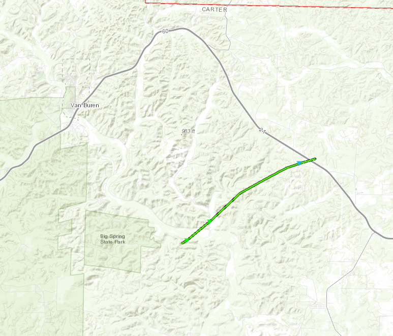
Tornado #3 - Chilton, Missouri
Carter County
| Date |
12/23/2015 |
| Time (CST) |
9:43 AM - 9:49 AM |
| EF Rating |
EF-1 |
| Est. Peak Winds |
95 mph |
| Path Length |
6 miles |
| Max Width |
100 yards |
| Injuries/Deaths |
0/0 |
|
Summary: OLD SCHOOL HOUSE WAS NEARLY DESTROYED. HUNDREDS OF TREES WERE EITHER SNAPPED IN HALF OR UPROOTED.
|
Track Map
|
Tornado #4 - Golden Gate, Illinois
Wayne County
| Date |
12/23/2015 |
| Time (CST) |
12:30 PM - 12:35 PM |
| EF Rating |
EF-1 |
| Est. Peak Winds |
95 mph |
| Path Length |
5 miles |
| Max Width |
100 yards |
| Injuries/Deaths |
0/0 |
|
Summary: A FEW UPROOTED TREES. SEVERAL TREES OR TREE BRANCHES SNAPPED. ONE HOME AND ONE BARN WITH ROOF/SHINGLE DAMAGE.
|
Track Map
.png)
|
Tornado #5 - Carmi, Illinois
White County
| Date |
12/23/2015 |
| Time (CST) |
12:25 PM - 12:28 PM |
| EF Rating |
EF-1 |
| Est. Peak Winds |
105 mph |
| Path Length |
1.25 miles |
| Max Width |
100 yards |
| Injuries/Deaths |
0/0 |
|
Summary: TORNADO BEGAN NEAR THE INTERSECTION OF 1500 N AND COUNTY RD 850 E AND ENDED JUST EAST OF BURRELL WOODS CAMPGROUND ON COUNTY RD 1575. NUMEROUS LARGE TREES WERE UPROOTED OR SNAPPED IN THE BURRELL WOODS CAMPGROUND AREA. NUMEROUS LARGE TREE LIMBS AND EVEN SOME LARGE TREE FORKS WERE ALSO SNAPPED. ONE LARGE TREE WAS UPROOTED AND BLOWN ONTO A DOG POUND NEAR BURREL WOODS CAMPGROUND.
|
Track Map
.png)
|
Tornado #6 - Mill Springs, Missouri
Wayne County
| Date |
12/23/2015 |
| Time (CST) |
9:56 AM - 9:59 AM |
| EF Rating |
EF-1 |
| Est. Peak Winds |
90 mph |
| Path Length |
3.5 miles |
| Max Width |
50 yards |
| Injuries/Deaths |
0/0 |
|
Summary: Several tree trunks snapped, a few trees uprooted, and several large tree branches broken or snapped.
|
Track Map
.png)
|
Tornado #7 - Patterson, Missouri
Wayne County
| Date |
12/23/2015 |
| Time (CST) |
10:08 AM - 10:11 AM |
| EF Rating |
EF-1 |
| Est. Peak Winds |
105 mph |
| Path Length |
3.5 miles |
| Max Width |
75 yards |
| Injuries/Deaths |
0/0 |
|
Summary: A couple dozen tree trunks snapped and some large tree branches broken or snapped.
|
Track Map
.png)
|
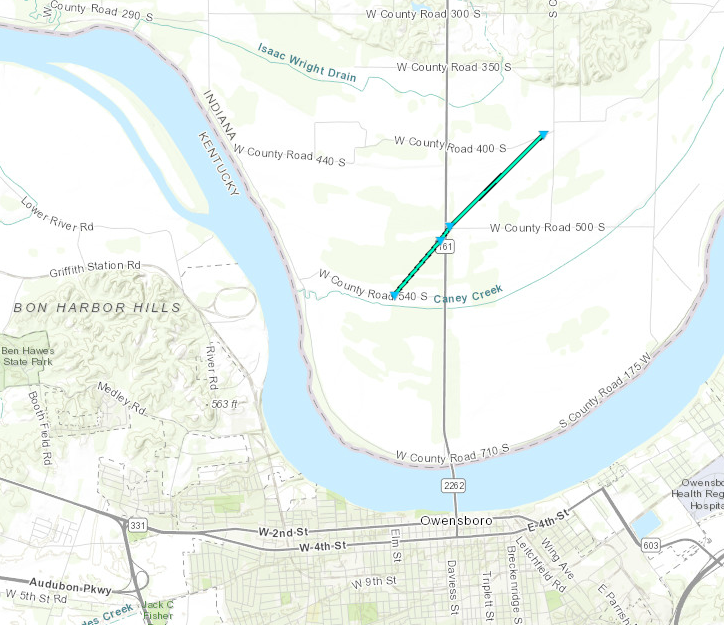
Tornado #8 - Owensboro North
Spencer County Indiana
| Date |
12/23/2015 |
| Time (CST) |
3:39 PM - 3:41 PM |
| EF Rating |
EF-0 |
| Est. Peak Winds |
75 mph |
| Path Length |
2 miles |
| Max Width |
50 yards |
| Injuries/Deaths |
0/0 |
|
Summary: Numerous tree limbs broken along with a few smaller trees snapped.
|
Track Map
|
The Enhanced Fujita (EF) Scale classifies tornadoes into the following categories:
EF0
Weak
65-85 mph |
EF1
Moderate
86-110 mph |
EF2
Significant
111-135 mph |
EF3
Severe
136-165 mph |
EF4
Extreme
166-200 mph |
EF5
Catastrophic
200+ mph |
 |


