Overview
|
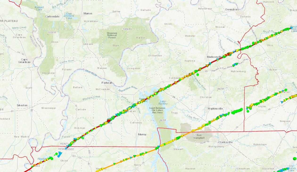
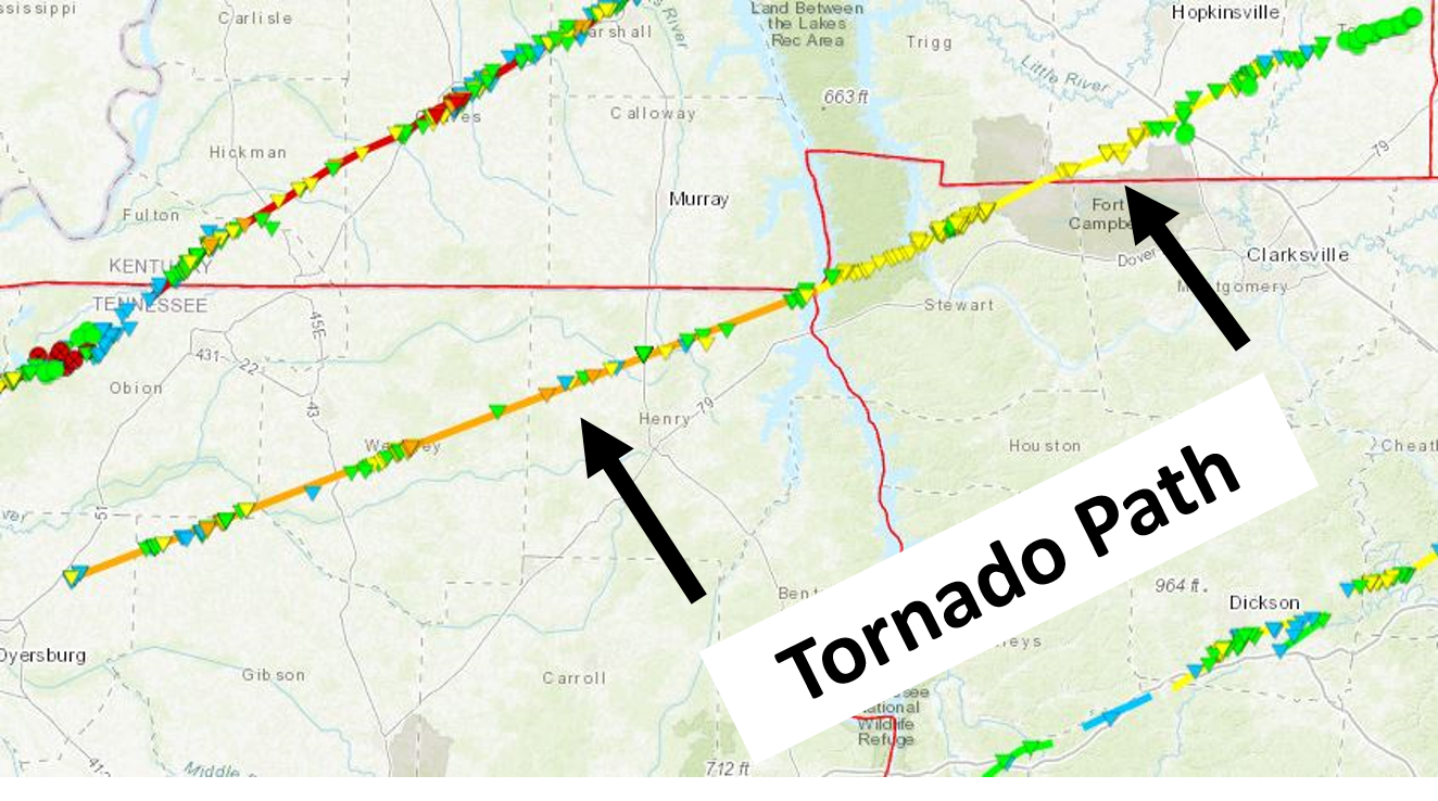
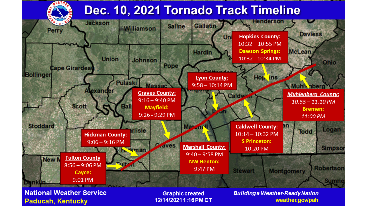
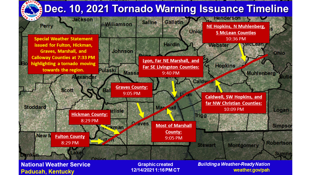
On the evening of Friday, December 10, 2021, a potent storm system moving across the central United States resulted in widespread severe weather across the region, including a significant long track tornadoes. NWS storm damage surveys found a violent EF-4 tornado began in far northwest Tennessee and moved across western Kentucky, resulting in significant destruction to portions of the region. The tornado began in Obion County, in northwest Tennessee, and tracked across 11 counties in western Kentucky: Fulton, Hickman, Graves, Marshall, Lyon, Caldwell, Hopkins, Muhlenberg, Ohio, Breckenridge, and Grayson. Its 165.7 mile long path length was on the longest for a tornado in U.S. history. Another long-track EF-3 tornado with estimated peak winds of 160 mph started in Dyer County, TN, and traveled 122.7 miles through northwest Tennessee and into Christian and Todd Counties in western Kentucky. Click here for an interactive StoryMap about the tornado outbreak that occurred across the region. |
 |
Tornadoes
Interactive Damage Survey Map - Zoom in and click the points to see damage information and pictures.
|
Tornado #1 - Long-Track EF-4 across western Kentucky
|
||||||||||||||||
|
||||||||||||||||
 |
Tornado #2 - Long-Track EF-3 across NW TN into W KY
|
||||||||||||||||
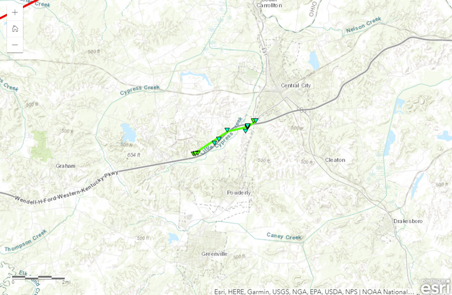
Tornado #3 - EF-1 Tornado near Central City, KY
|
||||||||||||||||
The Enhanced Fujita (EF) Scale classifies tornadoes into the following categories:
| EF0 Weak 65-85 mph |
EF1 Moderate 86-110 mph |
EF2 Significant 111-135 mph |
EF3 Severe 136-165 mph |
EF4 Extreme 166-200 mph |
EF5 Catastrophic 200+ mph |
 |
|||||
Photos & Video
|
Tornado devastation in Mayfield on December 11, 2021. |
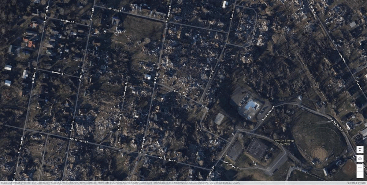
Tornado devastation in Dawson Springs on December 13, 2021. |
Tornado devastation in Bremen on December 13, 2021. |
 |
 |
 |
 |
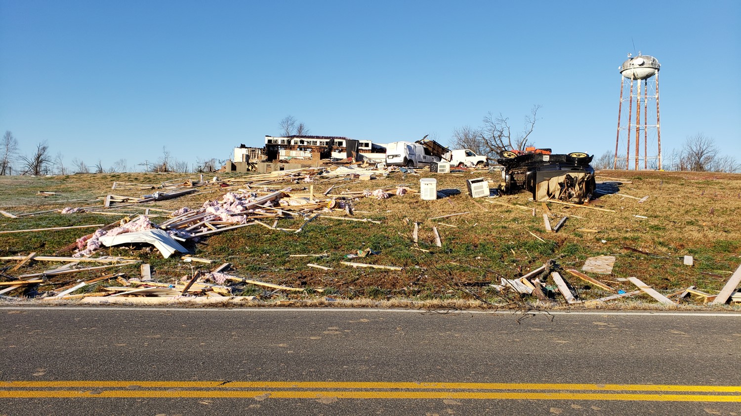
| Severe damage to a building in Cayce. (NWS Storm Survey) |
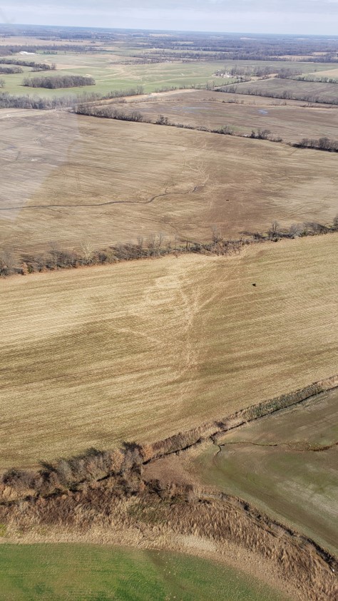
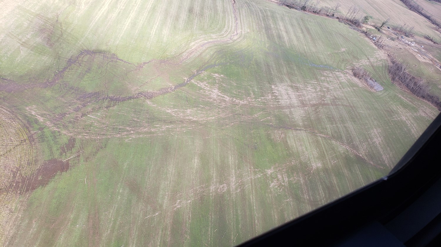
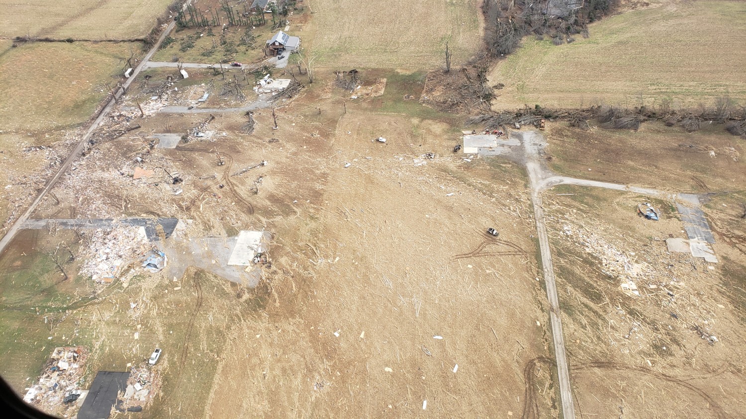
Tornado path across open fields northeast of Highway 116 to Highway 1127 in Fulton County. (NWS Storm Survey) | Poultry farm on Clark Road in Fulton County. (NWS Storm Survey) | Damage to a home in Cayce. (NWS Storm Survey) |
Hickman County
 |
 |
 |
 |
| Damage to a forest along Bayou de Chien in Hickman County. (NWS Storm Survey) | Tornado path through an open field south of Hodge Road in Hickman County. (NWS Storm Survey) |
Damage to a house in rural Hickman County. (NWS Storm Survey) | Uprooted trees on US 51 north of Sawmill Road in Hickman County. (NWS Storm Survey) |
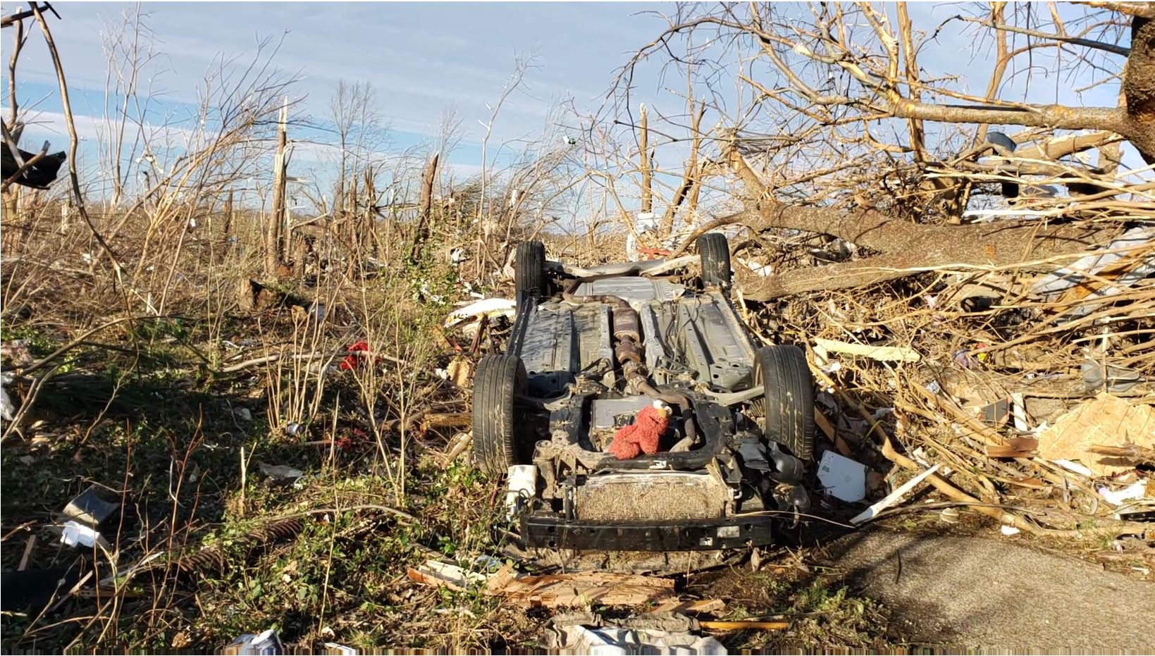
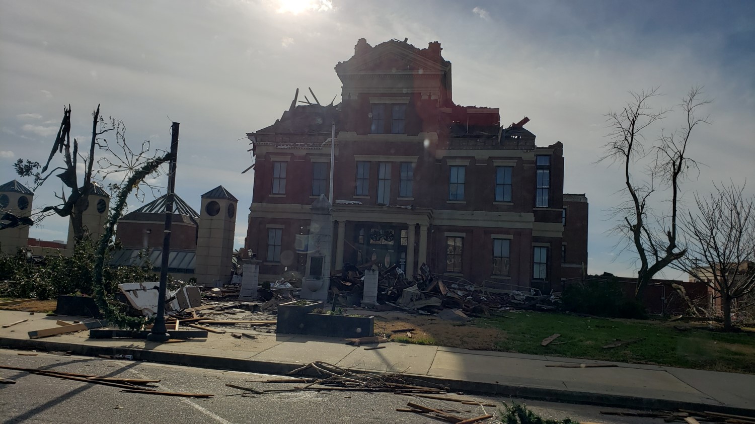
Graves County
 |
 |
 |
 |
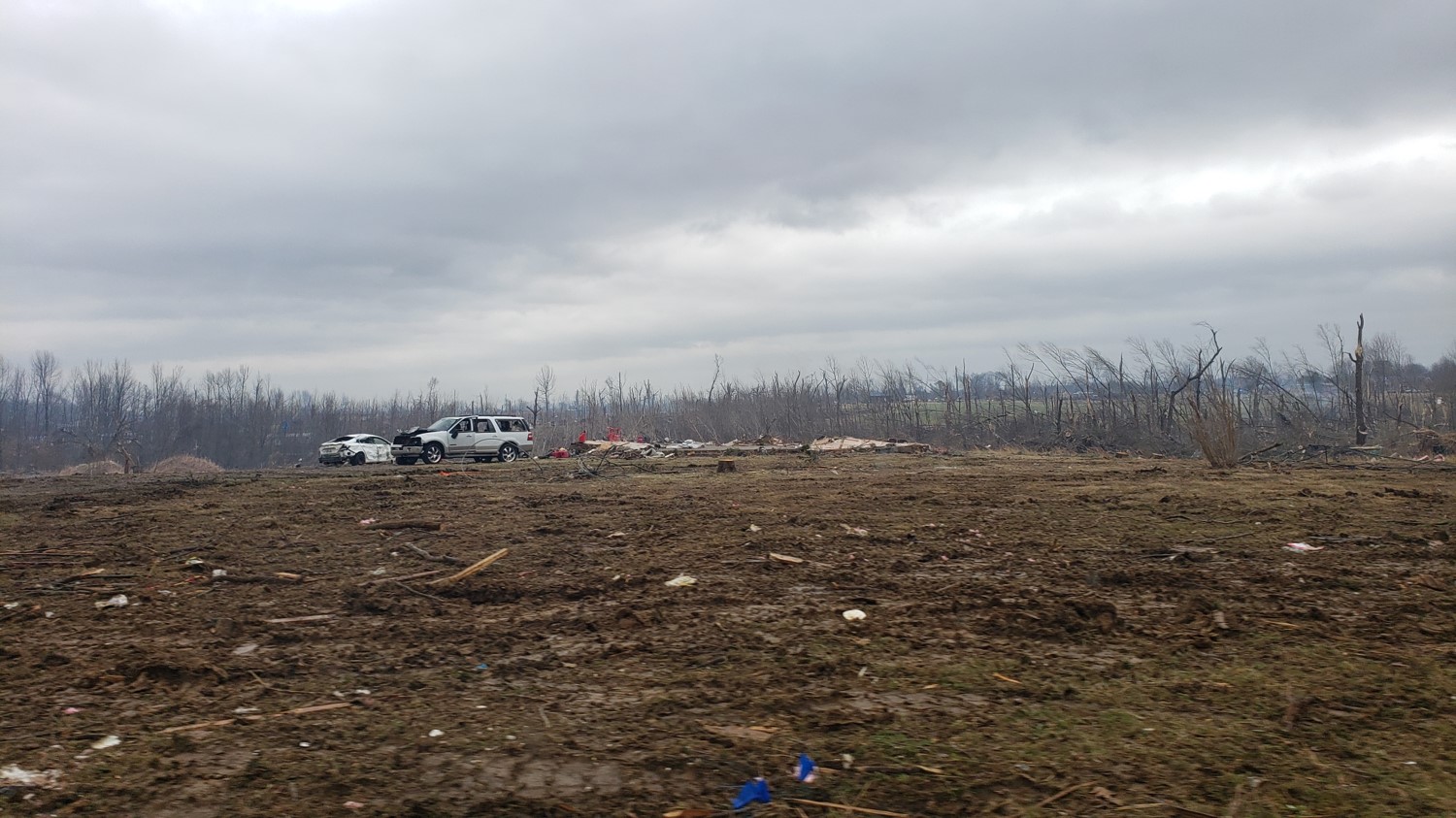
| Tornado devastation of Mayfield's central business district. (NWS Storm Survey) | Tossed vehicles and destroyed buildings in Mayfield. (NWS Storm Survey) | Tossed vehicles and destroyed buildings in Mayfield. (NWS Storm Survey) | Damage to trees and a home in Mayfield. (NWS Storm Survey) |
 |
 |
 |
 |
| Ground level view of the destruction in downtown Mayfield. (NWS Storm Survey) | Damage to a neighborhood in Mayfield. (NWS Storm Survey) |
Graves County Courthouse in downtown Mayfield. (NWS Storm Survey) | Damage to a medical center on Water Street in Mayfield. (NWS Storm Survey) |
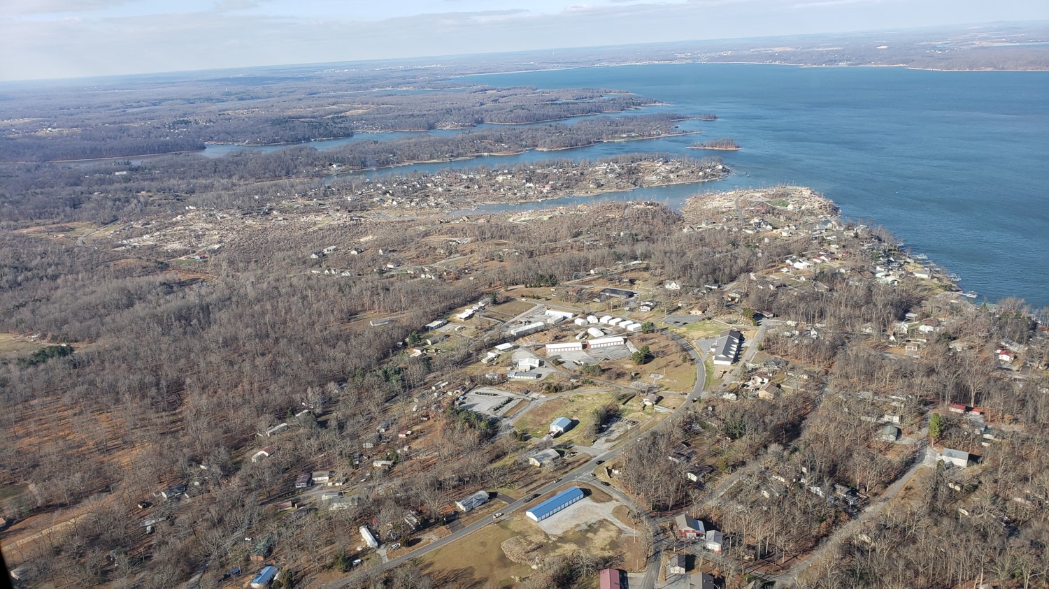
Marshall County
 |
 |
 |
 |
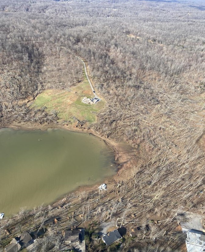
| Aerial view of the destruction of the Cambridge Shores community on Kentucky Lake (NWS Storm Survey) | Aerial view of damage to the Cambridge Shores and Sherwood Shores communities on Kentucky Lake. (NWS Storm Survey) |
Destruction in Cambridge Shores. (NWS Storm Survey) |
Destruction in Cambridge Shores looking east across Kentucky Lake. (NWS Storm Survey) |
Lyon County
 |
 |
 |
 |
| Forest destruction in the Land Between the Lake NRA. (NWS Storm Survey) | Devastated forecast at Hillman Ferry in Land Between the Lakes NRA. (Montana Mike) |
Kelsey Joe Lane along Lake Barkley in Lyon County. (NWS Storm Survey) | Blueridge Road near Lake Barkley in Lyon County. (NWS Storm Survey) |
Caldwell County
 |
 |
 |
 |
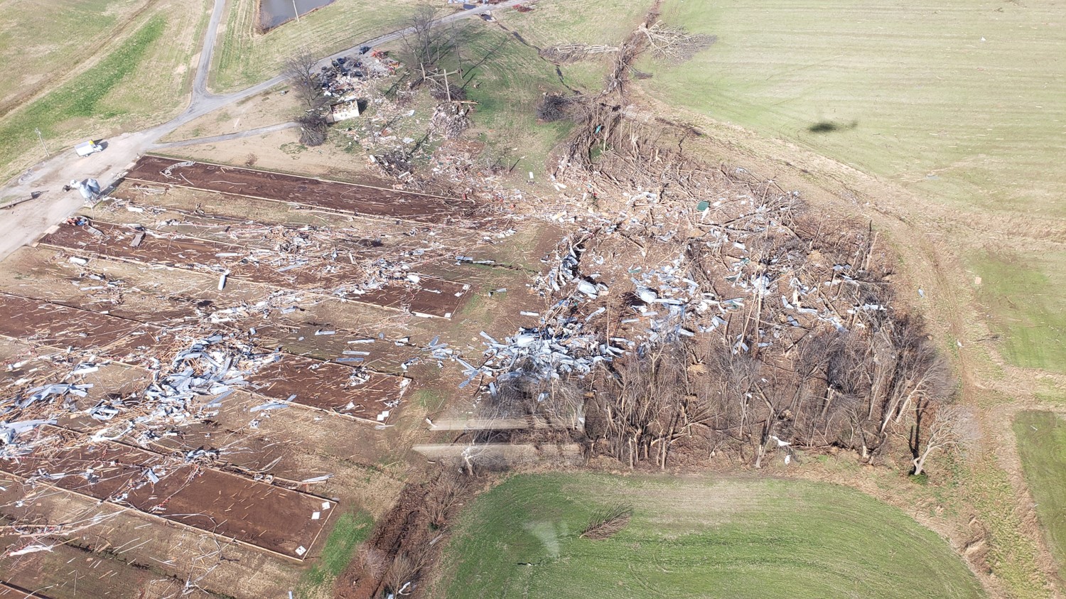
| University of Kentucky Research and Education Center south of Princeton. (NWS Storm Survey) | University of Kentucky Research and Education Center south of Princeton. (NWS Storm Survey) |
Damage to several homes in a neighborhood at the Princeton County Club. (NWS Storm Survey) | Damaged homes on US 62 west of Dawson Springs in Lyon County. (NWS Storm Survey) |
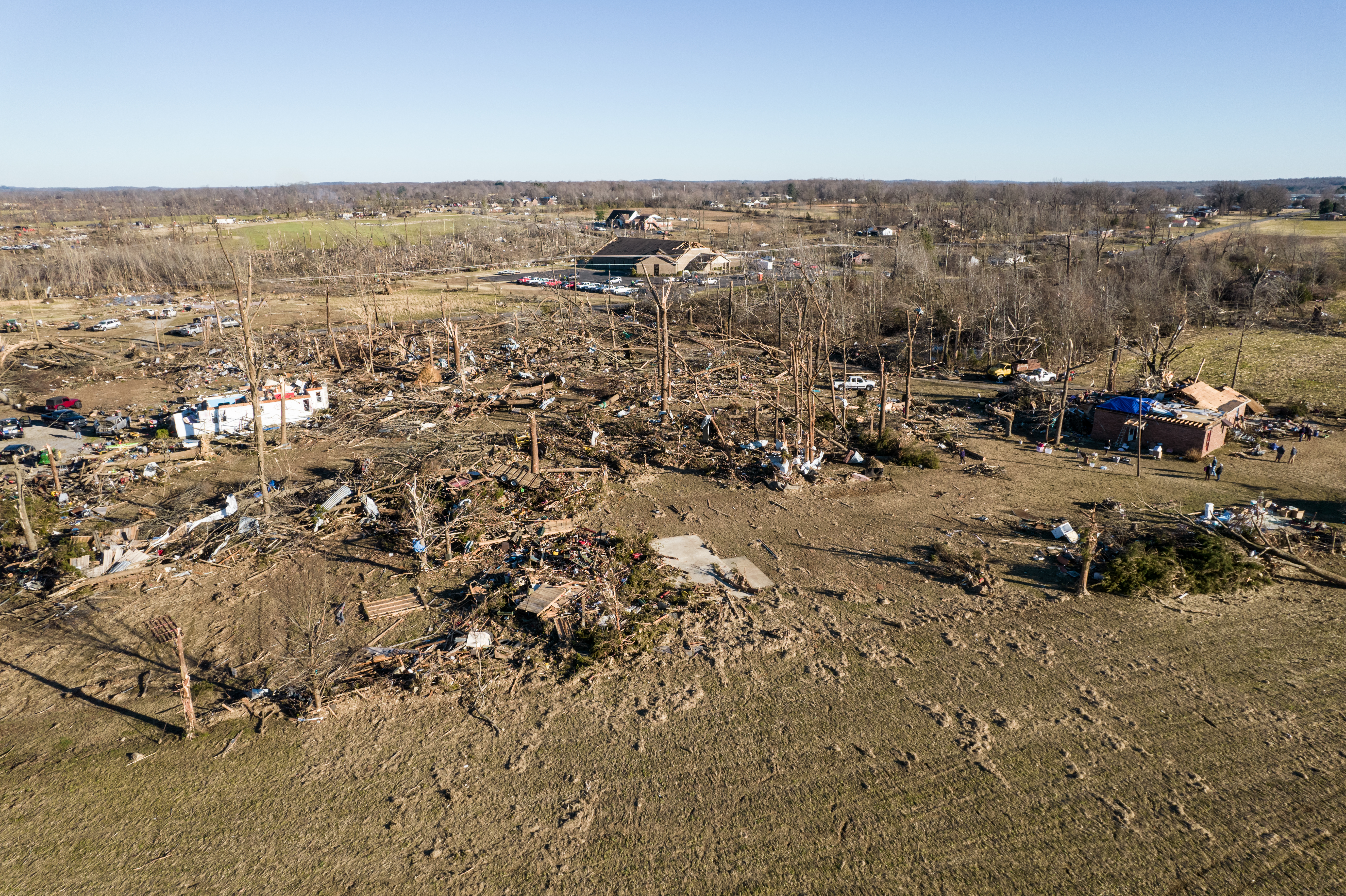
Hopkins County
 |
 |
 |
 |
| Pine Street in Dawson Springs. (NWS Storm Survey) |
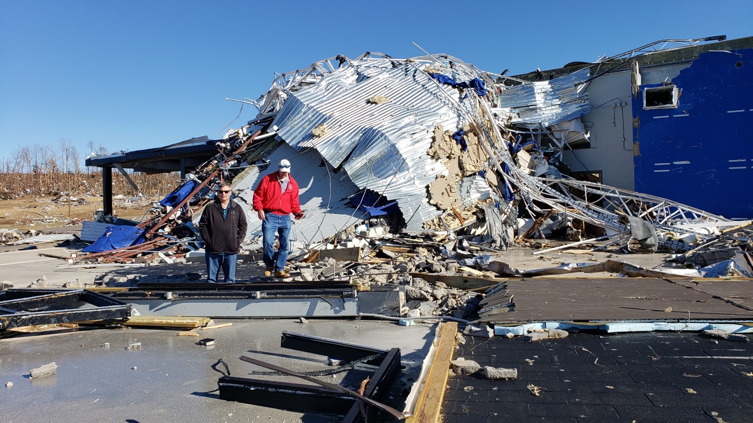
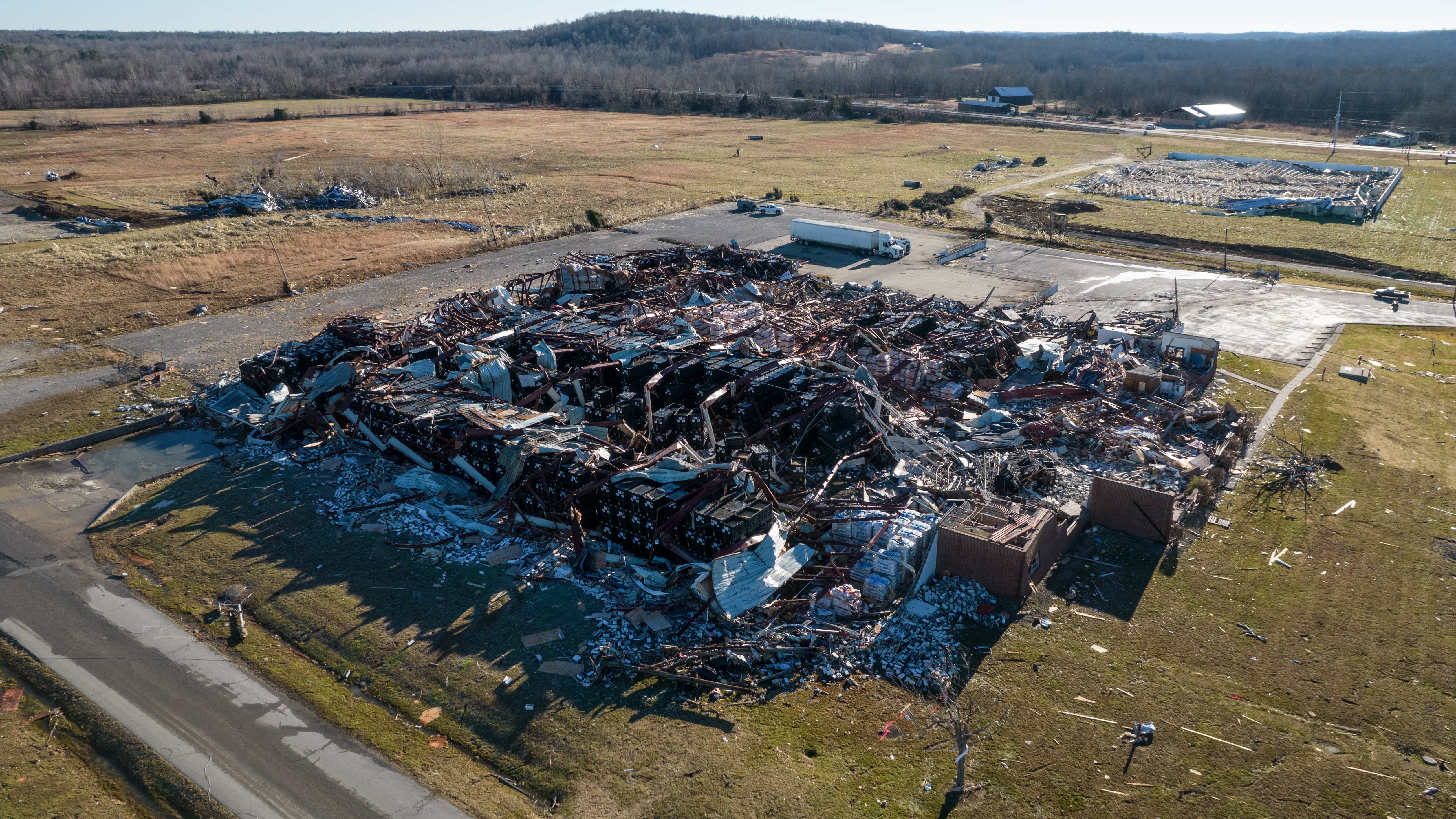
Damage to factory in Dawson Springs. (Chris Conley) |
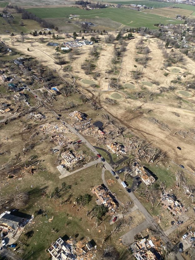
Aerial footage of damage in Dawson Springs. (Chris Conley) | Aerial footage of damage in Dawson Springs. (Chris Conley) |
 |
 |
 |
 |
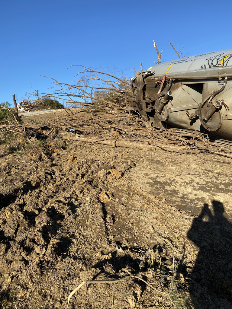
| Train derailment in Barnsley. (NWS Storm Survey) |
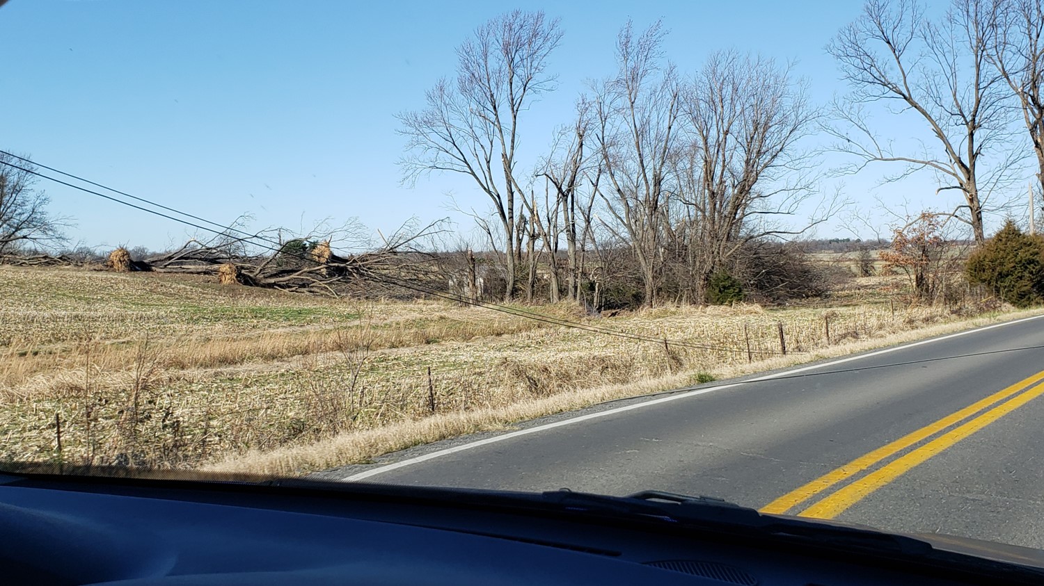
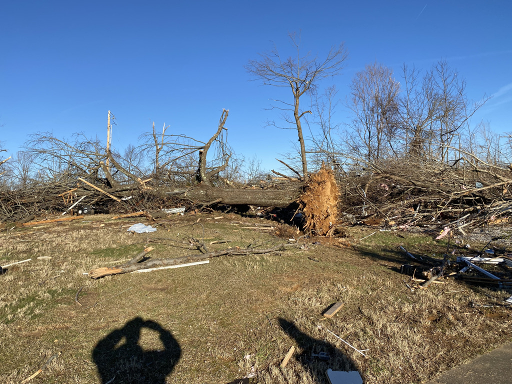
Tree damage in Barnsley. (NWS Storm Survey) |
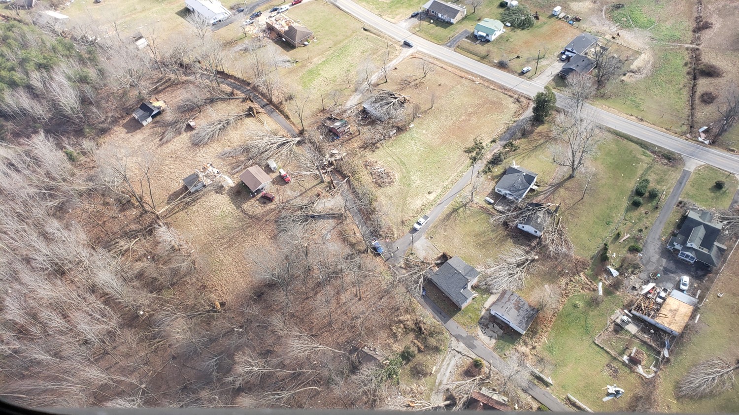
Destroyed neighborhood near the city park in Dawson Springs. (Chris Conley) | Destroyed neighborhood near the city park in Dawson Springs. (Chris Conley) |
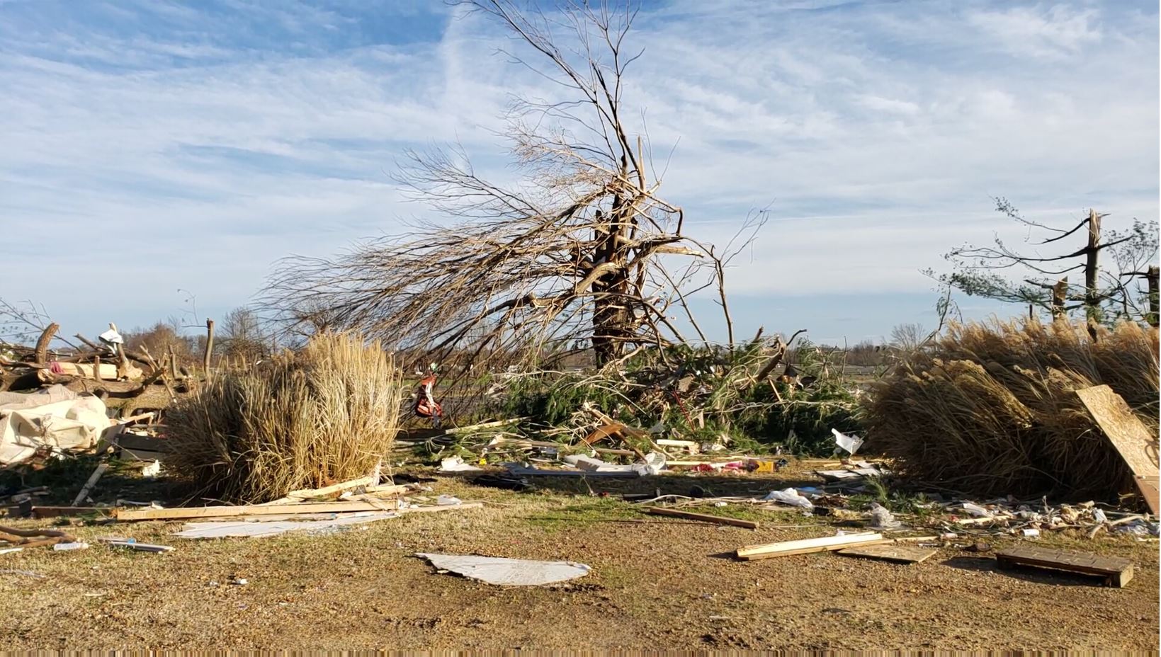
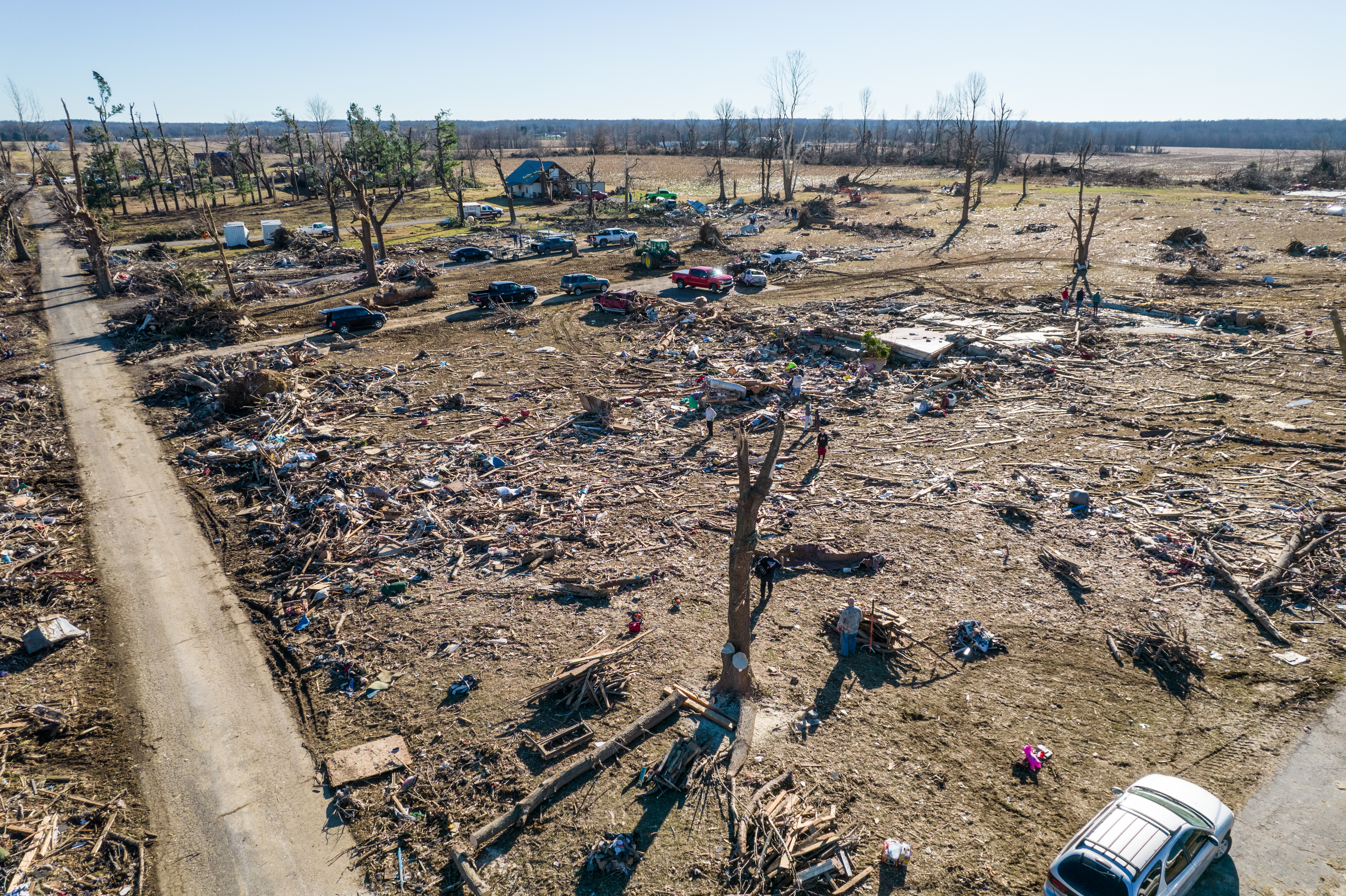
Muhlenberg County
 |
 |
 |
 |
| Complete destruction of a home near Bremen. (NWS Storm Survey) | Complete destruction of homes on Bethlehem Cemetery Road in Bremen. (NWS Storm Survey) |
Aerial footage of damage in Bremen. (Chris Conley) |
Aerial footage of damage in Bremen. (Chris Conley) |
|
The CBS program 60 Minutes interviewed staff from NWS Paducah and survivors of the tornado to share the power of its devastation with the world. |
|
NWS Paducah Lead Meteorologist Chris Noles did an in-depth interview with ABC News on its Good Morning America program about the tornado outbreak. |
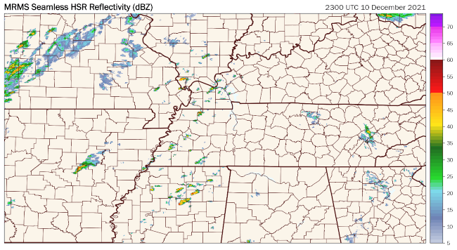
Radar
Click here for an interactive radar loop for the entire event.
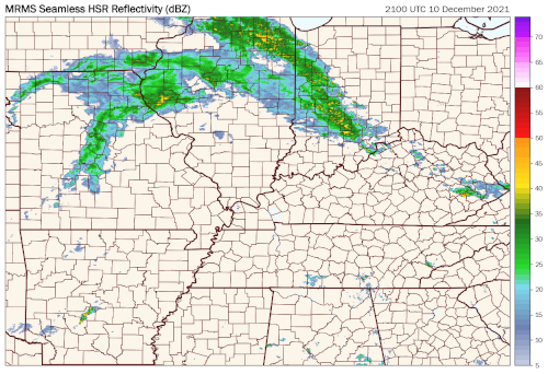 |
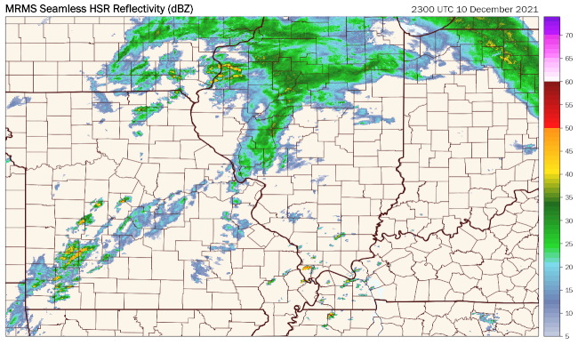 |
 |
| Regional radar loop across the Lower Ohio and Mississippi River valleys from 6 PM Dec. 10 to 8 AM Dec. 11. (Tomer Burg/Univ. of Oklahoma) | Regional radar loop across the Lower Ohio and Mid-Mississippi River valleys from 6 PM Dec. 10 to 8 AM Dec. 11. (Tomer Burg/Univ. of Oklahoma)
|
Regional radar loop across the Lower Ohio and Lower Mississippi River valleys from 6 PM Dec. 10 to 8 AM Dec. 11. (Tomer Burg/Univ. of Oklahoma) |
 |
 |
 |
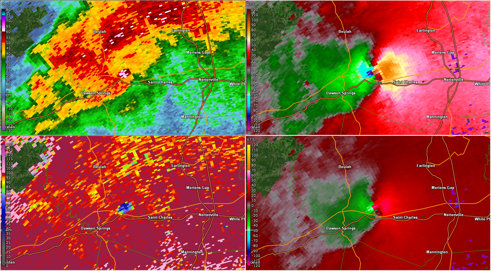 |
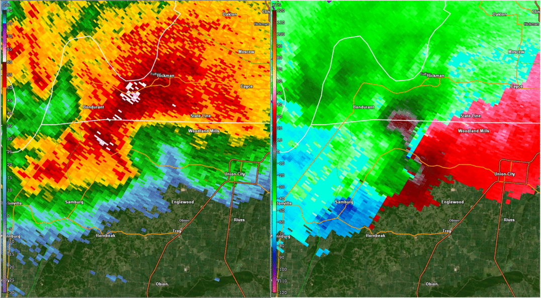
| Radar Loop from KPAH from 8:46 PM CST to 10:02 PM CST (Left: Base Reflectivity Right: Base Velocity) |
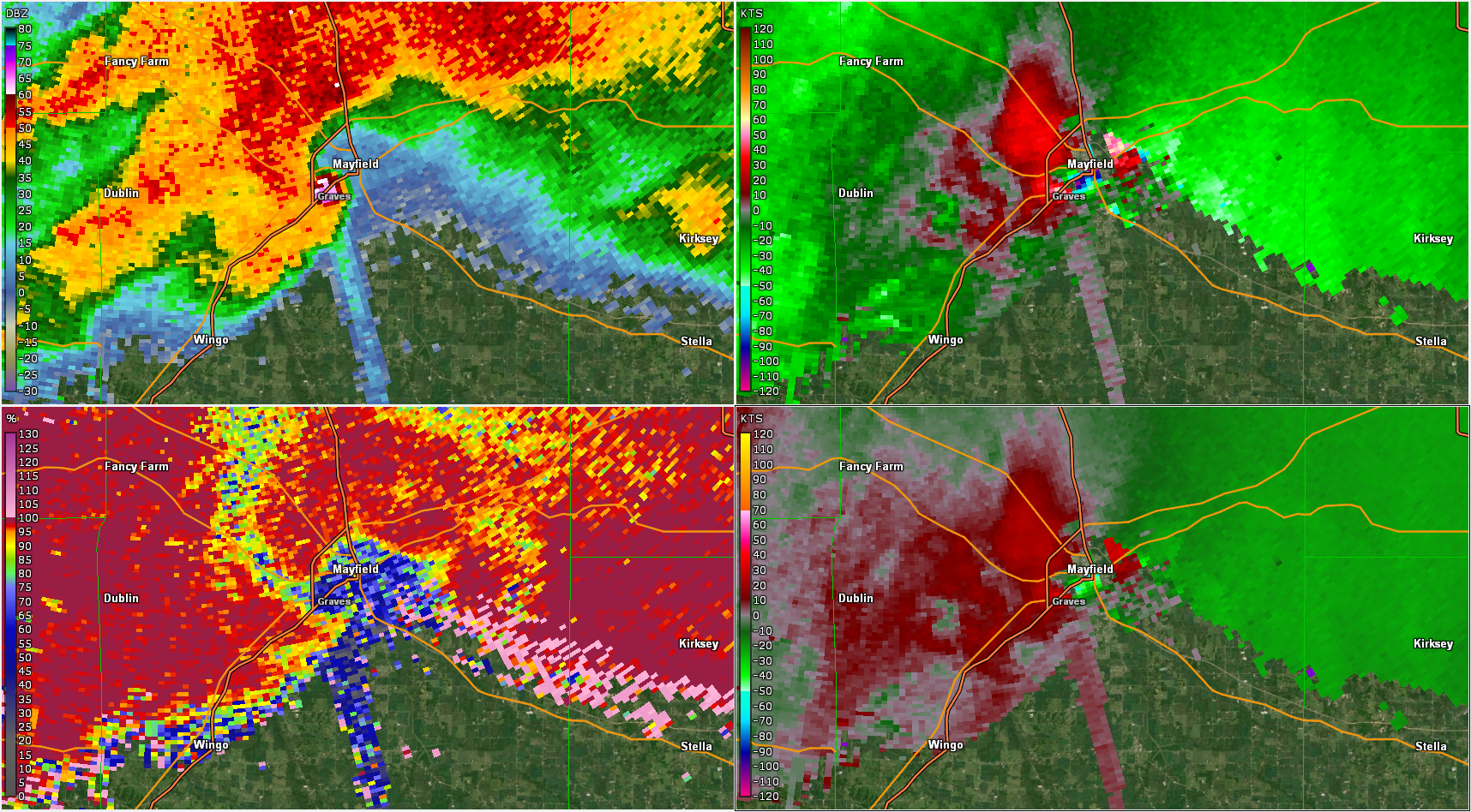
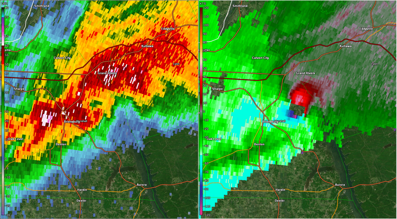
9:27 PM CST: Clockwise from top left: Base Reflectivity, Base Velocity, Storm Relative Velocity, Correlation Coefficient KPAH at Mayfield, KY | Radar Loop from KHPX from 9:55 PM CST to 11:22 PM CST (Left: Base Reflectivity Right: Base Velocity) |
10:36 PM CST: Clockwise from top left: Base Reflectivity, Base Velocity, Storm Relative Velocity, Correlation Coefficient KHPX near Dawson Springs, KY |
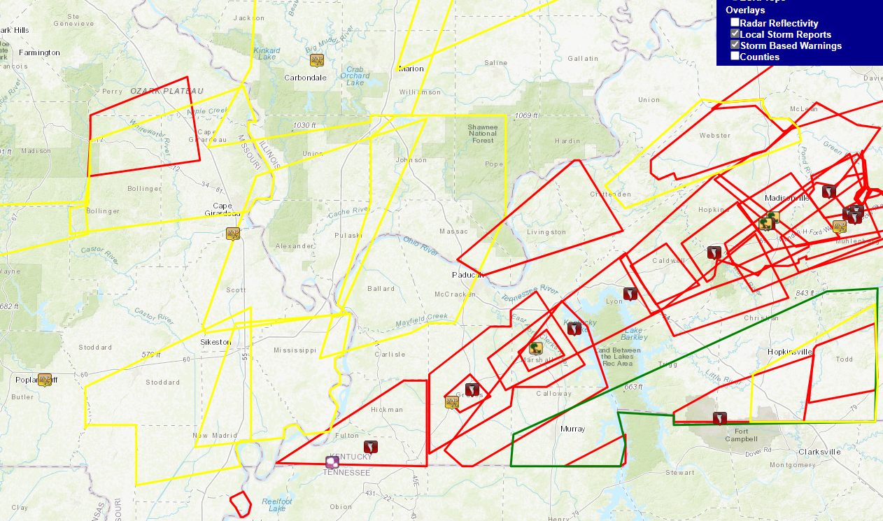
Storm Reports
Map of storm reports and warning polygons
(red=Tornado Warning, yellow=Severe Tstm Warning)
PRELIMINARY LOCAL STORM REPORT...SUMMARY
NATIONAL WEATHER SERVICE PADUCAH KY
1012 AM CST WED DEC 15 2021
..TIME... ...EVENT... ...CITY LOCATION... ...LAT.LON...
..DATE... ....MAG.... ..COUNTY LOCATION..ST.. ...SOURCE....
..REMARKS..
0838 PM TORNADO 2 WSW CENTRAL CITY 37.29N 87.16W
12/10/2021 MUHLENBERG KY STORM CHASER
POWER FLASHES JUST NORTH OF THE WEST
KENTUCKY PARKWAY JUST WEST OF CENTRAL CITY.
POWER IS OUT.
0839 PM TORNADO 1 SW CENTRAL CITY 37.28N 87.14W
12/10/2021 MUHLENBERG KY STORM CHASER
DEBRIS FROM HOMES AND BILLBOARDS ALONG THE
WEST KENTUCKY PARKWAY JUST WEST OF CENTRAL
CITY.
0841 PM TSTM WND GST 5 W ASH HILL 36.77N 90.32W
12/10/2021 M54 MPH BUTLER MO ASOS
ASOS STATION KPOF POPLAR BLUFF MO.
0845 PM TORNADO CENTRAL CITY 37.30N 87.13W
12/10/2021 MUHLENBERG KY TRAINED SPOTTER
DAMAGE TO HARDWARE STORE ON WEST EVERLY
BROS. BLVD.
0855 PM HAIL 4 S HICKMAN 36.51N 89.19W
12/10/2021 E1.75 INCH FULTON KY TRAINED SPOTTER
0901 PM TORNADO CAYCE 36.56N 89.04W
12/10/2021 FULTON KY AMATEUR RADIO
DAMAGE REPORTED IN CAYCE TO A CAFE AND THE
FIRE DEPARTMENT.
0917 PM NON-TSTM WND DMG 2 WNW POWDERLY 37.25N 87.20W
12/10/2021 MUHLENBERG KY PUBLIC
TREES DOWN AND DAMAGE TO A CARPORT.
0924 PM HAIL 2 N MAYFIELD 36.77N 88.65W
12/10/2021 M1.75 INCH GRAVES KY PUBLIC
0924 PM TSTM WND GST 4 NNE WINGO 36.70N 88.72W
12/10/2021 M107 MPH GRAVES KY MESONET
MESONET STATION PRYB MAYFIELD KY 6 SW.
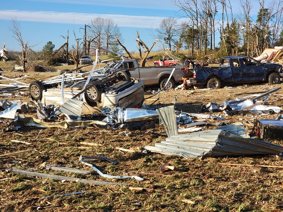
0925 PM TORNADO 1 NE MAYFIELD 36.74N 88.64W
12/10/2021 GRAVES KY NWS STORM SURVEY
*** 20 FATAL ***
TOTAL DESTRUCTION OF DOZENS OF HOMES AND
BUSINESSES. DAMAGE SURVEY IS ONGOING, BUT A
MINIMUM OF EF-3 DAMAGE HAS OCCURRED. THE
TORNADO TRACKED ACROSS THE ENTIRETY OF
GRAVES COUNTY, ENTERING FROM HICKMAN COUNTY
ABOUT 5 MILES W OF WINGO, PASSING THROUGH
THE CENTER OF MAYFIELD BEFORE MOVING ENE AND
EXITING INTO MARSHALL COUNTY ABOUT 10 MILES
NE OF MAYFIELD RIGHT ALONG I-69. PRELIMINARY
ESTIMATE OF 20 FATALITIES IN THE COUNTY.
0927 PM TORNADO MAYFIELD 36.74N 88.64W
12/10/2021 GRAVES KY BROADCAST MEDIA
MAJOR DAMAGE REPORTED IN MAYFIELD. NO
FURTHER DETAILS AVAILABLE AT THIS TIME.
0945 PM TSTM WND DMG 2 WNW BENTON 36.87N 88.39W
12/10/2021 MARSHALL KY TRAINED SPOTTER
A MOBILE HOME ON JACKSON SCHOOL ROAD WAS
COMPLETELY DESTROYED. A NEARBY GARAGE WAS
SWEPT OFF ITS FOUNDATION. POSSIBLE TORNADO.
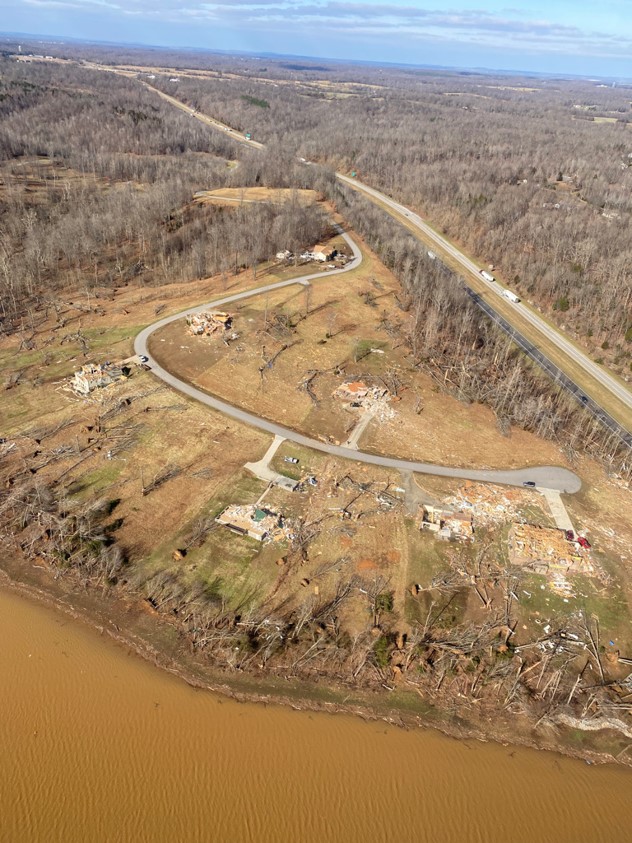
0958 PM TORNADO 5 S GRAND RIVERS 36.93N 88.24W
12/10/2021 MARSHALL KY NWS STORM SURVEY
*** 2 FATAL ***
TOTAL DESTRUCTION OF DOZENS OF HOMES IN THE
CAMBRIDGE SHORES AND SHERWOOD SHORES AREAS
ALONG KY LAKE. DAMAGE SURVEYS ARE ONGOING,
BUT A MINIMUM OF EF-3 DAMAGE HAS OCCURRED.
MAX PATH WIDTH APPROXIMATELY 3/4 TO 1 MILE
WIDE. PRELIMINARY ESTIMATE OF 2 FATALITIES.
DAMAGE SURVEY RESULTS REVEAL THE TORNADO WAS
ON THE GROUND ACROSS THE ENTIRETY OF
MARSHALL COUNTY FROM APPROXIMATELY 8 MILES
WSW OF BENTON, PASSING BY JUST NORTH OF
BENTON, AND CONTINUING ONTO KY LAKE.
1015 PM TORNADO 4 SE EDDYVILLE 37.04N 88.02W
12/10/2021 LYON KY NWS STORM SURVEY
*** 1 FATAL ***
CONSIDERABLE DAMAGE OF DOZENS OF HOMES IN
THE BELL HOLLOW AREA ALONG LAKE BARKLEY,
SOME OF WHICH WERE COMPLETED DESTROYED. 1
FATALITY OCCURRED ON KELSEY JOE LANE JUST
WEST OF I-24. DAMAGE SURVEYS ARE ONGOING,
BUT A MINIMUM OF EF-3 DAMAGE HAS OCCURRED.
MAX PATH WIDTH APPROXIMATELY 3/4 TO 1 MILE
WIDE. THE TORNADO PASSED THROUGH THE NORTH
END OF LBL AND MOVED ACROSS LAKE BARKLEY,
PASSING BY ABOUT 4-5 MILES SOUTH OF
EDDYVILLE BEFORE CROSSING INTO CALDWELL
COUNTY.
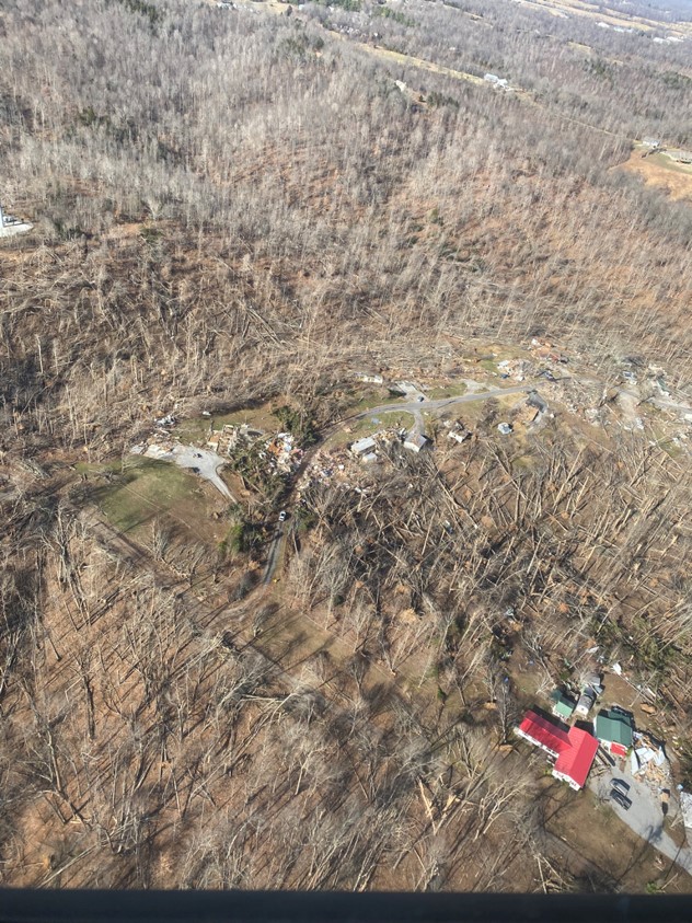
1030 PM TORNADO DAWSON SPRINGS 37.17N 87.69W
12/10/2021 HOPKINS KY NWS STORM SURVEY
*** 12 FATAL ***
TOTAL DESTRUCTION OF DOZENS OF HOMES. DAMAGE
SURVEY IS ONGOING ACROSS THE COUNTY, BUT A
MINIMUM OF EF-3 DAMAGE HAS OCCURRED IN THE
DAWSON SPRINGS AREA. PRELIMINARY ESTIMATE OF
12 FATALITIES OCCURRED.
1040 PM TSTM WND DMG DAWSON SPRINGS 37.17N 87.69W
12/10/2021 HOPKINS KY EMERGENCY MNGR
MAJOR DAMAGE WITH BUILDINGS LEVELED,
MULTIPLE INJURIES.
1052 PM TORNADO 1 NNW MORTONS GAP 37.26N 87.48W
12/10/2021 HOPKINS KY TRAINED SPOTTER
POSSIBLE RAIN WRAPPED TORNADO BETWEEN
MORTONS GAP AND EARLINGTON.
1052 PM TSTM WND DMG 2 NNW MORTONS GAP 37.26N 87.49W
12/10/2021 HOPKINS KY TRAINED SPOTTER
TRAIN CARS KNOCKED OFF TRACK NEAR THE
COMMUNITY OF BARNSLEY.
1052 PM TSTM WND DMG 2 NNW MORTONS GAP 37.26N 87.49W
12/10/2021 HOPKINS KY TRAINED SPOTTER
TREES AND POWER LINES/POLES DOWN AND
STRUCTURAL DAMAGE IN BARNSLEY.
1057 PM TSTM WND DMG 3 NNE MORTONS GAP 37.28N 87.46W
12/10/2021 HOPKINS KY TRAINED SPOTTER
SEMI AND CARS FLIPPED OFF INTERSTATE 69 NEAR
EARLINGTON.
1100 PM TORNADO 1 W BREMEN 37.36N 87.24W
12/10/2021 MUHLENBERG KY NWS STORM SURVEY
*** 11 FATAL ***
TOTAL DESTRUCTION OF DOZENS OF HOMES. DAMAGE
SURVEYS ARE ONGOING, BUT A MINIMUM OF EF-3
DAMAGE HAS OCCURRED. PRELIMINARY ESTIMATE OF
11 FATALITIES IN THE BREMEN AREA. MAX WIDTH
IS ESTIMATED TO BE BETWEEN 3/4 AND 1 MILE
WIDE. THE TORNADO ENTERED MUHLENBERG COUNTY
FROM HOPKINS COUNTY ALONG HWY 70 ABOUT 6
MILES NORTHWEST OF GRAHAM. IT MOVED ENE AND
INTO THE NORTHWEST PORTION OF BREMEN BEFORE
MOVING ALONG THOROFARE ROAD AND EXITING THE
COUNTY ALONG THE GREEN RIVER 6 MILES NNE OF
SOUTH CARROLTON.
1148 PM TSTM WND GST 3 SSW DE SOTO 37.77N 89.25W
12/10/2021 M64 MPH JACKSON IL ASOS
MEASURED BY CARBONDALE AIRPORT ASOS.
1215 AM TORNADO 1 WSW LAFAYETTE 36.65N 87.67W
12/11/2021 CHRISTIAN KY PUBLIC
POSSIBLE TORNADO JUST SOUTHWEST OF
LAFAYETTE.
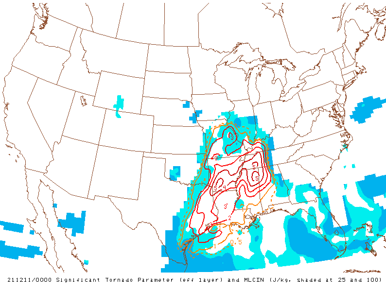
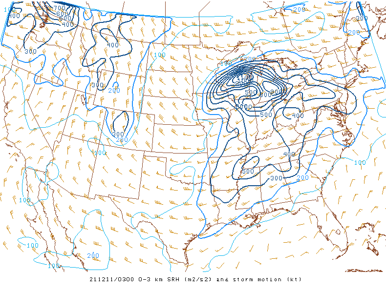
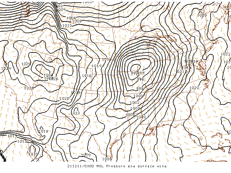
Environment
 |
 |
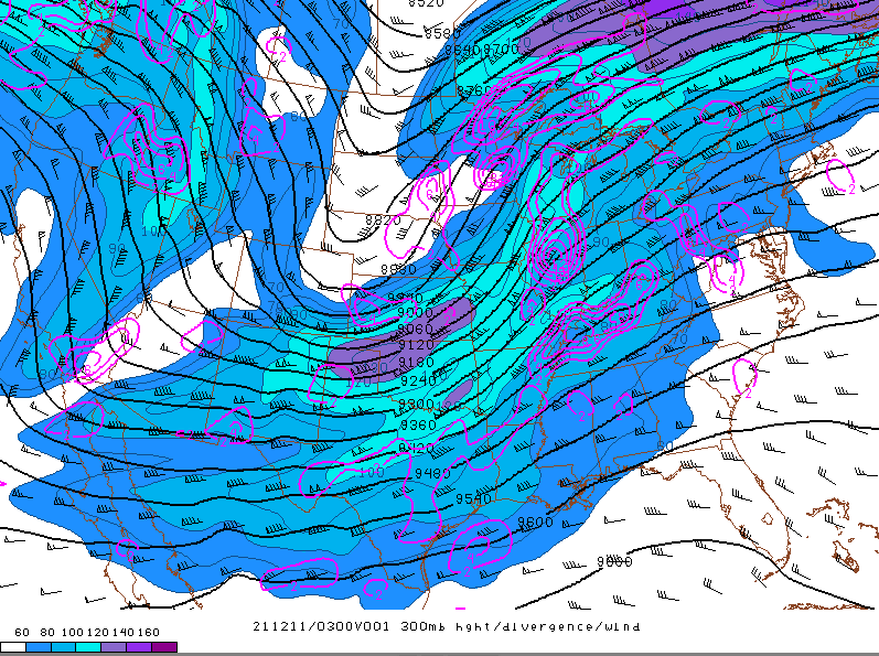 |
| Sig Tor Parameter at 6 PM | 0-3 km SRH valid at 9 PM | 300mb wind and height at 9 PM |
 |
 |
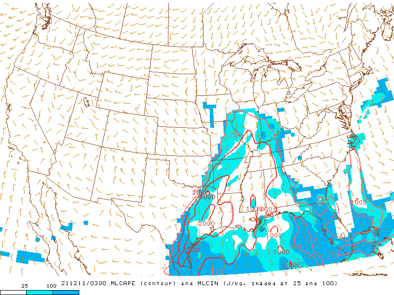 |
| 0-1km SRH at 9 PM | Surface map valid at 9 PM | Mixed-layer cape at 9 PM |
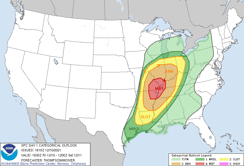
Additional Information
 |
 |
 |
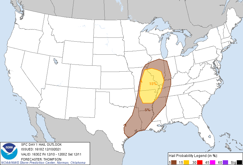 |
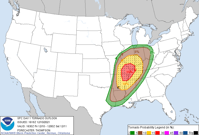
| SPC Day 1 Outlook update issued at 10:18 AM | SPC Day 1 Tornado Probability issued at 10:18 AM | SPC Day 1 Wind Probability issued at 10:18 AM | SPC Day 1 Hail Probability issued at 10:18 AM |
 |
 |
 |
|
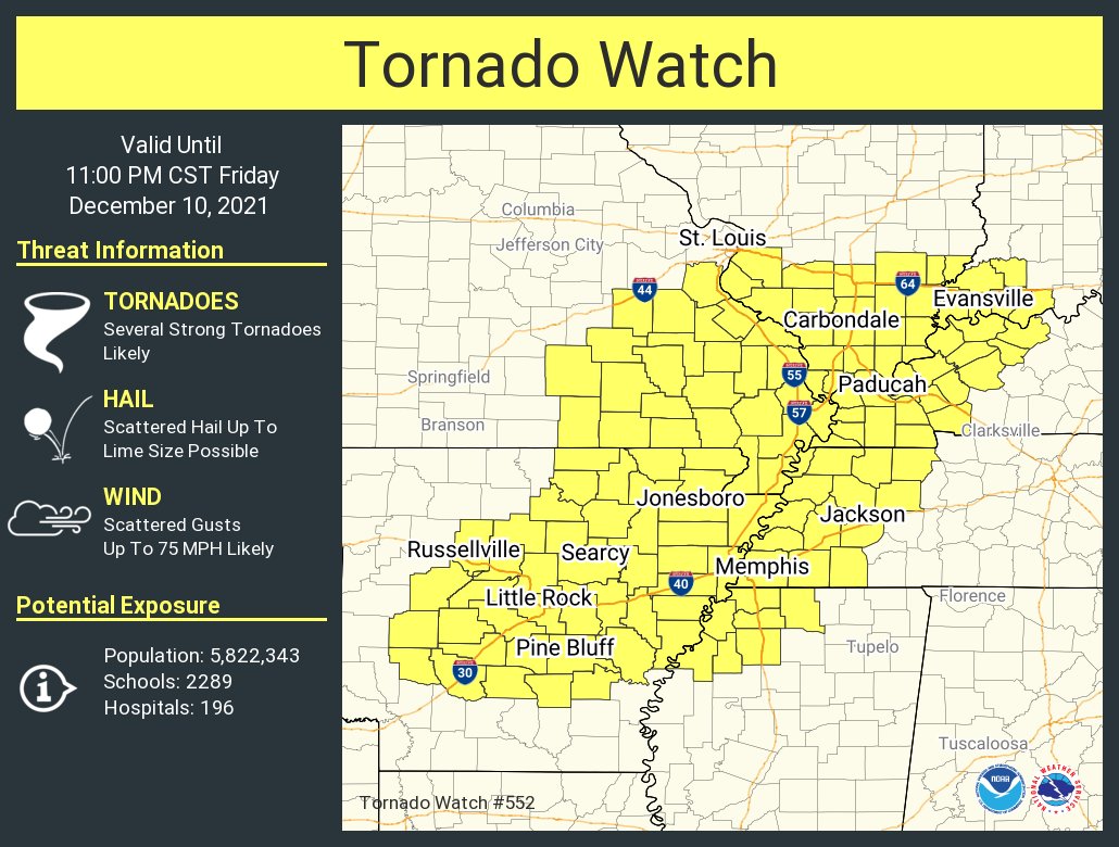
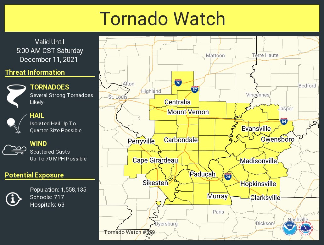
Tornado Watch #552. |
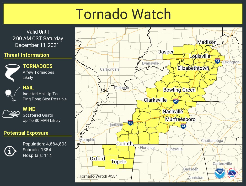
Tornado Watch #554. | Tornado Watch #559. |
Recovery
 |
 |
 |
 |
|
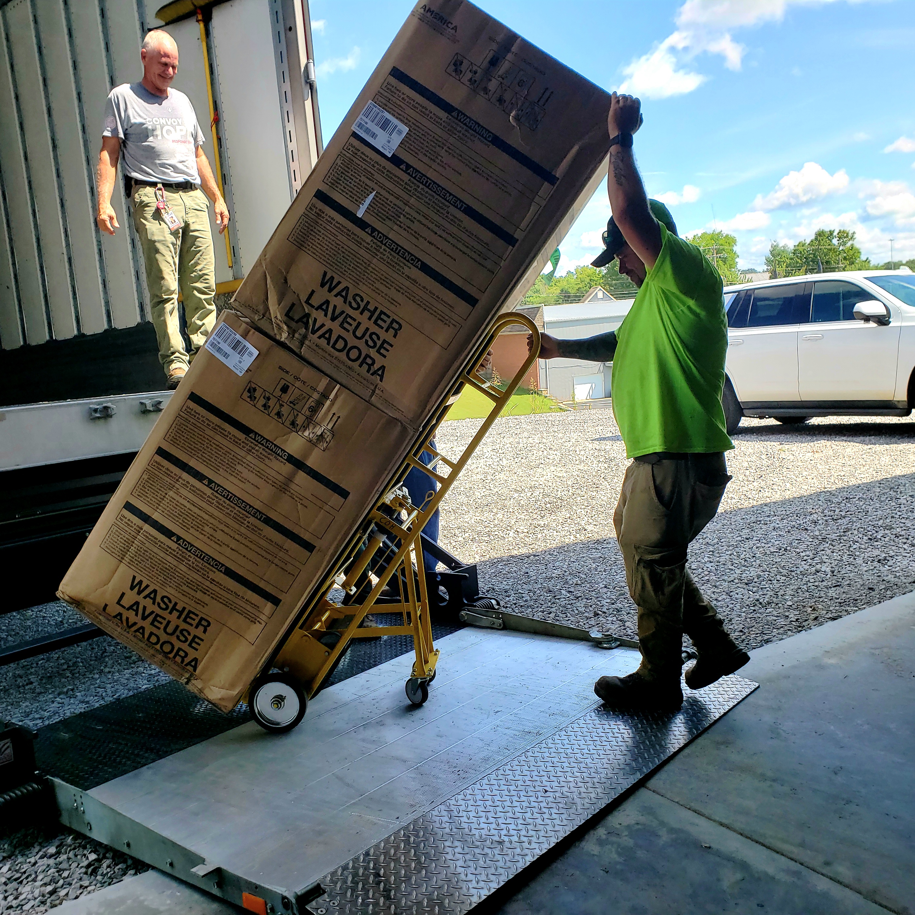
Convoy of Hope in Lyon County (Lyon County EMA) |
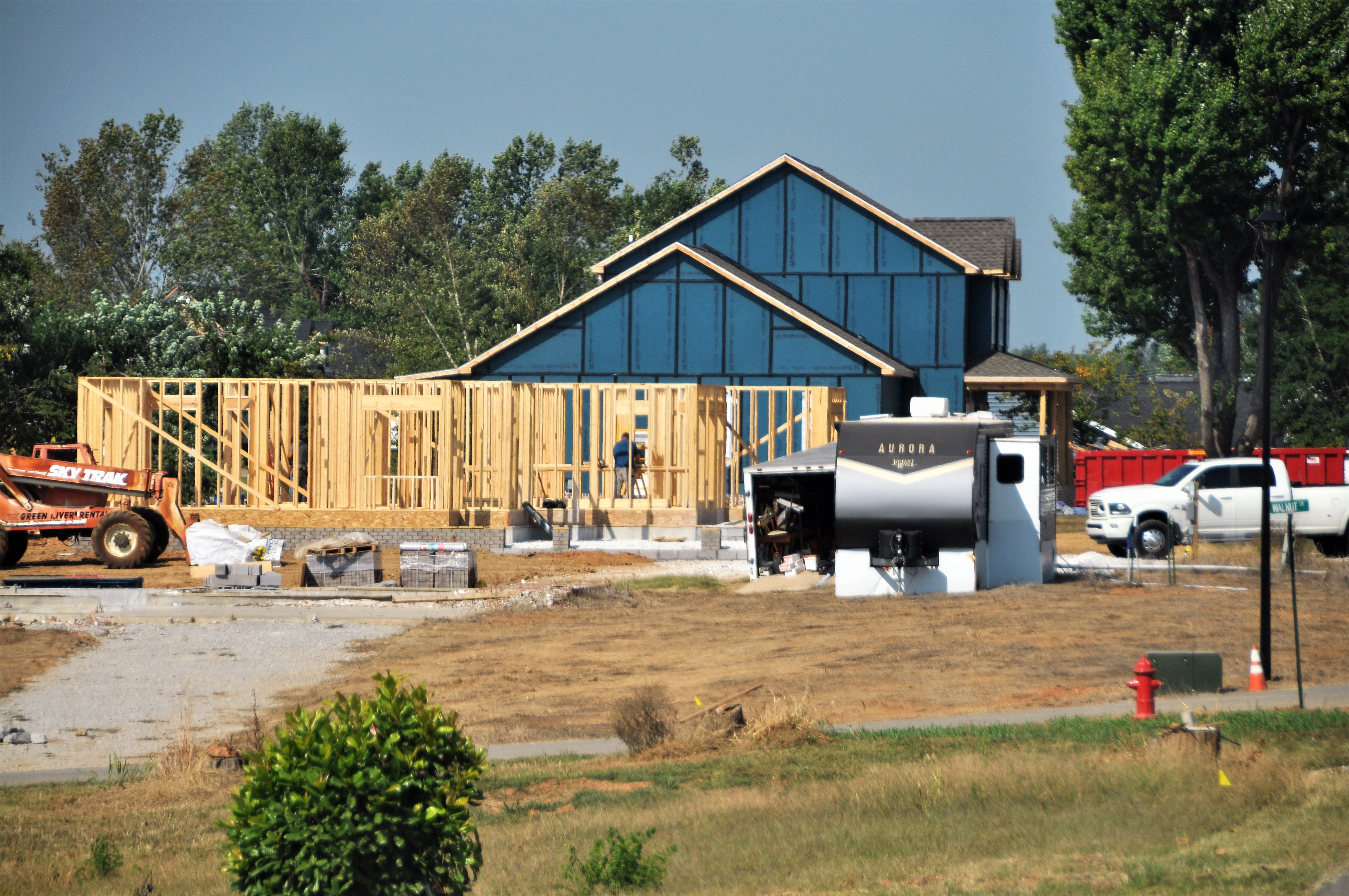
Rebuilding homes in Lyon County (Lyon County EMA) |
Rebuilding homes in Lyon County (Lyon County EMA) |
Delivering new appliances to tornado victims in Lyon County (Lyon County EMA) |
|
Recovery efforts in Princeton, Dawson Springs, and Bremen. Filmed in August 2022 by Chris Conley/270 Drone Aerial Imagery. |
Time lapse of home reconstruction in Mayfield. |