Overview
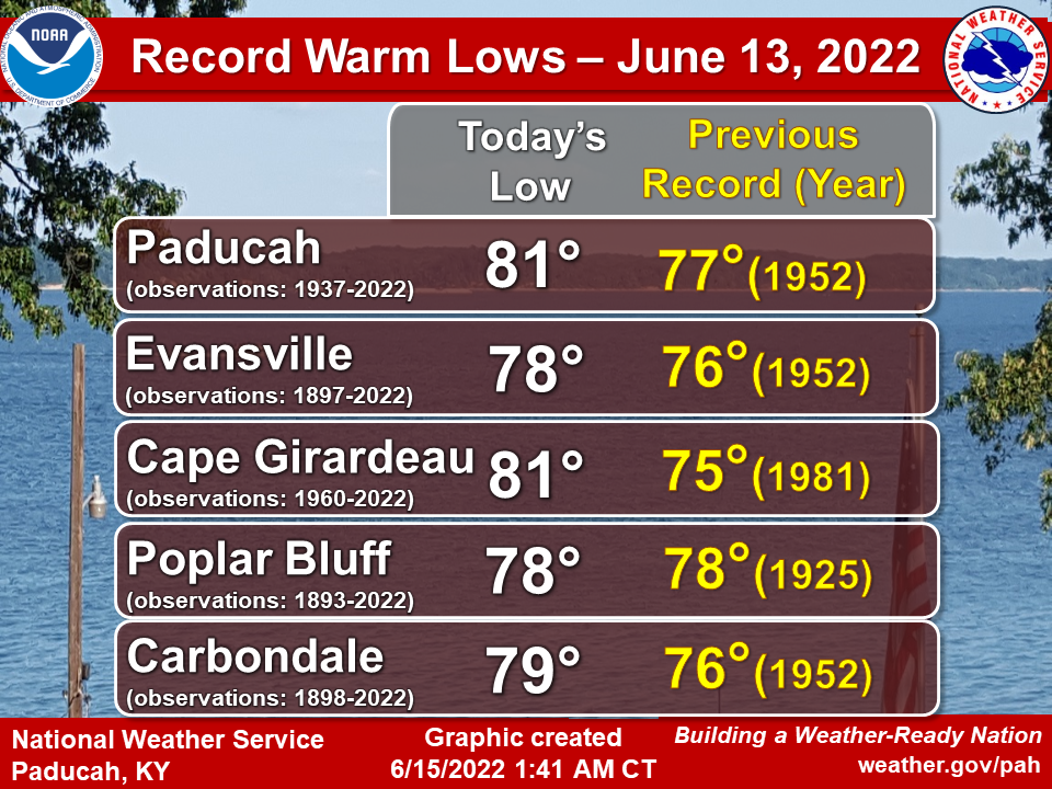
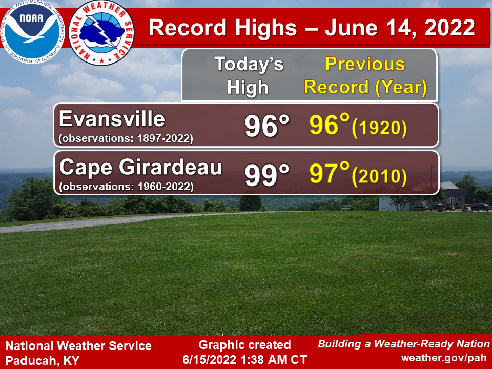
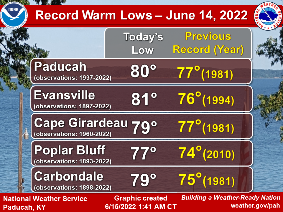
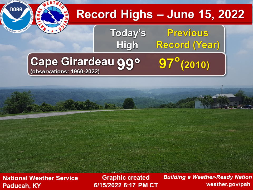
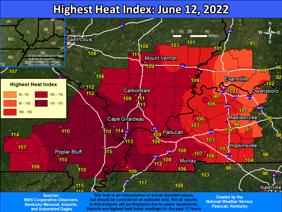
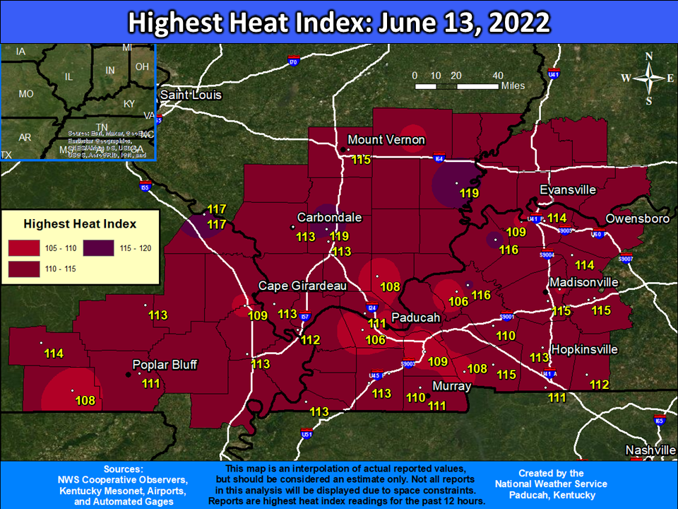
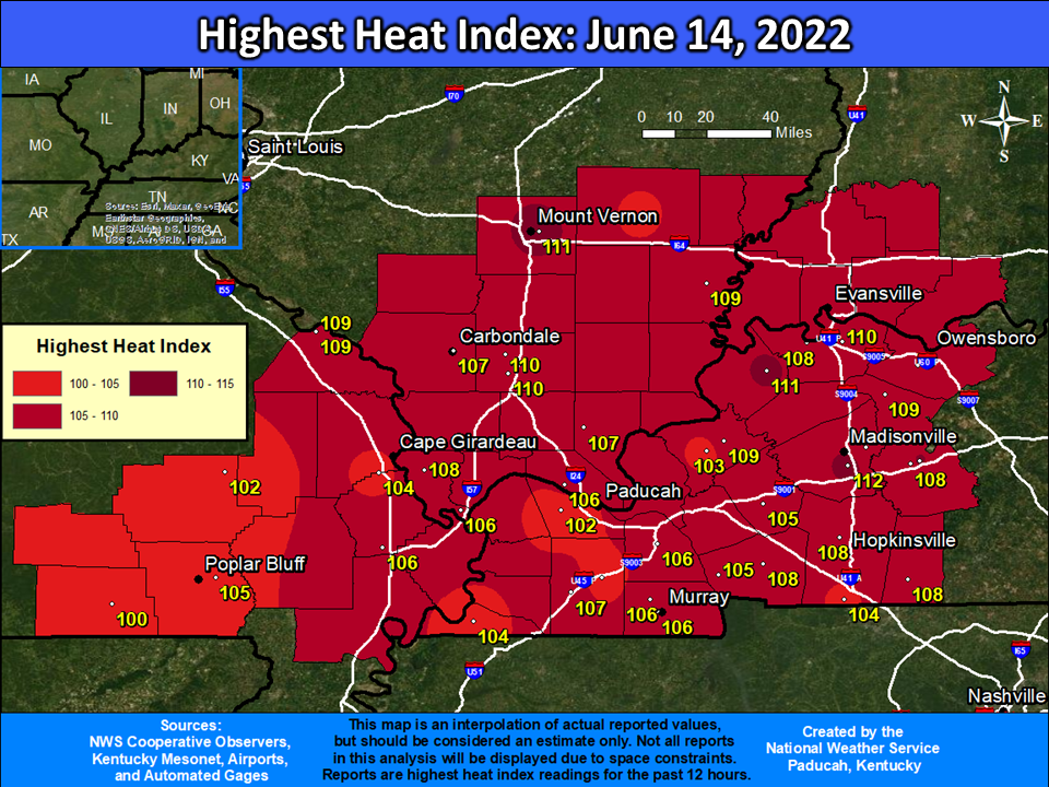
A strong upper level ridge of high pressure developed across the Ohio and Tennessee Valley, producing a record breaking early season heat wave. Numerous record highs and warm lows were established across our forecast area, including the first triple digit temperatures experienced since 2016 in Cape Girardeau, MO and 2013 in Poplar Bluff, MO. Low temperatures in the 80s were observed in several locations, setting monthly and all-time records in some cases. Heat index values exceeded 105 degrees starting on June 12 and continued through June 16. The most oppressive day was June 13th, when dewpoints in the mid 70s to around 80 produced heat index values of 110 to nearly 120.
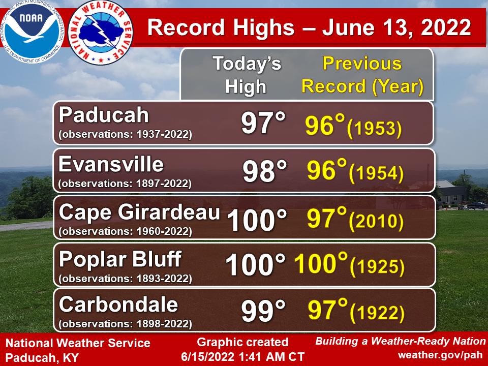
Records:
Numerous record highs and warm lows were set during this heat wave. Paducah and Evansville tied their June all-time warmest low temperature of 81 degrees. Meanwhile, Cape Girardeau broke their June record and tied their all-time warmest low record of 81 degrees. This was the earliest in the season that 80 degree low temperatures had ever been observed at all 3 of these sites. This was only the 2nd time on record that Paducah observed 4 consecutive days reaching 95 degrees this early in the season (before June 20). The other occurrence was back in 1952 with 8 straight days at or above 95 degrees from June 9-16.
 |
 |
 |
 |
 |
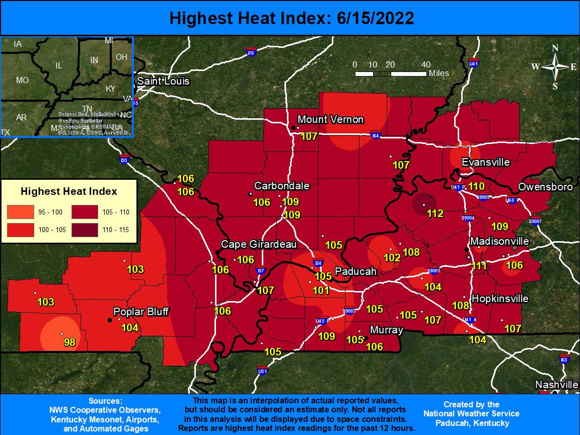
Heat Index Graphics and Table:
Observed Heat Index Readings Sunday June 12th through Thursday June 16th, 2022 (Click images to enlarge)
 |
 |
 |
 |
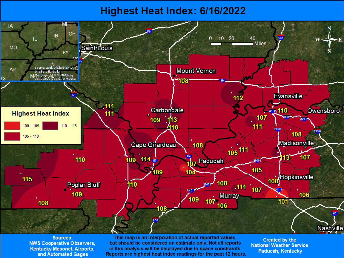 |
The table below shows the maximum daily heat index readings observed at all airport locations (ASOS/AWOS) and Kentucky Mesonet stations across our 58 county forecast area. These are the most reliable and accurate stations across the region. The bottom row of the chart gives the highest daily heat index reading observed across the area from these 32 stations. The heat index is calculated from a combination of air temperatures and dewpoint temperatures or relative humidity.
Maximum Daily Heat Index Readings:
| Location | State | Station Type | June 12 | June 13 | June 14 | June 15 | June 16 |
| Cape Girardeau | MO | ASOS | 110 | 109 | 104 | 106 | 109 |
| Carbondale | IL | ASOS | 109 | 113 | 107 | 106 | 109 |
| Evansville | IN | ASOS | 95 | 110 | 106 | 103 | 106 |
| Paducah | KY | ASOS | 106 | 106 | 102 | 101 | 104 |
| Poplar Bluff | MO | ASOS | 110 | 111 | 105 | 104 | 109 |
| Cairo | IL | AWOS | 113 | 112 | 106 | 107 | 109 |
| Murray | KY | AWOS | 111 | 110 | 106 | 105 | 107 |
| Fort Campbell | KY | AWOS | 97 | 111 | 104 | 104 | 101 |
| Owensboro | KY | AWOS | 98 | 111 | 107 | 107 | 106 |
| Mayfield | KY | AWOS | 108 | 110 | 103 | 103 | 106 |
| Henderson | KY | AWOS | 99 | 109 | 108 | 103 | 107 |
| Madisonville | KY | AWOS | 99 | 109 | 105 | 103 | 106 |
| Mt Vernon | IL | AWOS | 109 | 115 | 111 | 107 | 108 |
| Fairfield | IL | AWOS | 102 | 109 | 104 | 101 | 105 |
| Carmi | IL | AWOS | 109 | 119 | 109 | 107 | 112 |
| Marion | IL | AWOS | 111 | 119 | 110 | 109 | 113 |
| 5 NNE La Center (Ballard Co.) |
KY | Mesonet | 110 | 113 | 107 | 107 | 110 |
| 2 SE Princeton (Caldwell Co.) |
KY | Mesonet | 103 | 110 | 105 | 104 | 105 |
| 1 W Murray (Calloway Co.) | KY | Mesonet | 106 | 111 | 106 | 106 | 106 |
| 6 N Hopkinsville (Christian Co.) |
KY | Mesonet | 103 | 113 | 108 | 108 | 106 |
| 4 NE Marion (Crittenden Co.) |
KY | Mesonet | 106 | 116 | 109 | 108 | 111 |
| 2 E Hickman (Fulton Co.) | KY | Mesonet | 109 | 113 | 104 | 105 | 108 |
| 6 SW Mayfield (Graves Co.) | KY | Mesonet | 112 | 113 | 107 | 109 | 109 |
| 5 E Henderson (Henderson Co.) |
KY | Mesonet | 101 | 114 | 110 | 110 | 110 |
| 4 S Madisonville (Hopkins Co.) |
KY | Mesonet | 102 | 115 | 112 | 111 | 113 |
| 4 N Benton (Marshall Co.) | KY | Mesonet | 108 | 109 | 106 | 105 | 108 |
| 5 NW Calhoun (McLean Co.) |
KY | Mesonet | 101 | 114 | 109 | 109 | 108 |
| 6 N Greenville (Muhlenberg Co.) |
KY | Mesonet | 100 | 113 | 111 | 107 | 108 |
| 5 SW Elkton (Todd Co.) | KY | Mesonet | 104 | 112 | 108 | 107 | 106 |
| 4 SW Cadiz (Trigg Co.) | KY | Mesonet | 106 | 115 | 108 | 107 | 107 |
| 4 E Morganfield (Union Co.) | KY | Mesonet | 106 | 116 | 111 | 112 | 111 |
| 1 NW Dixon (Webster Co.) | KY | Mesonet | 102 | 110 | 109 | 107 | 107 |
| Daily Maximum: | 113 | 119 | 112 | 112 | 113 |
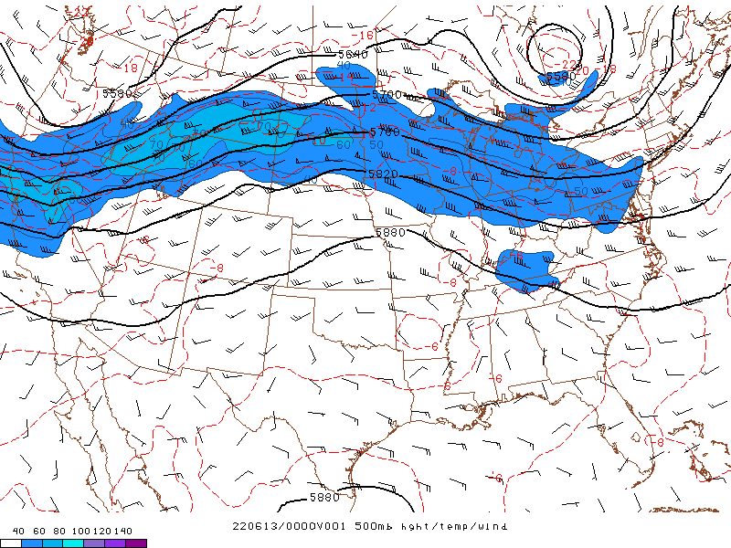
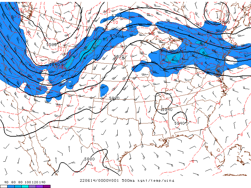
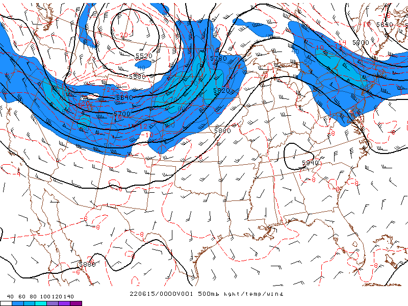
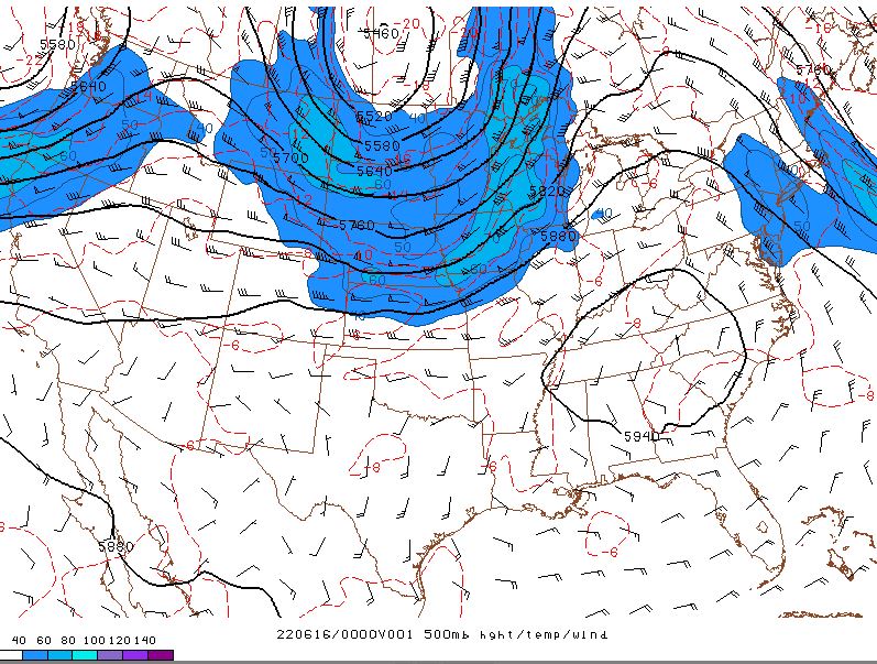
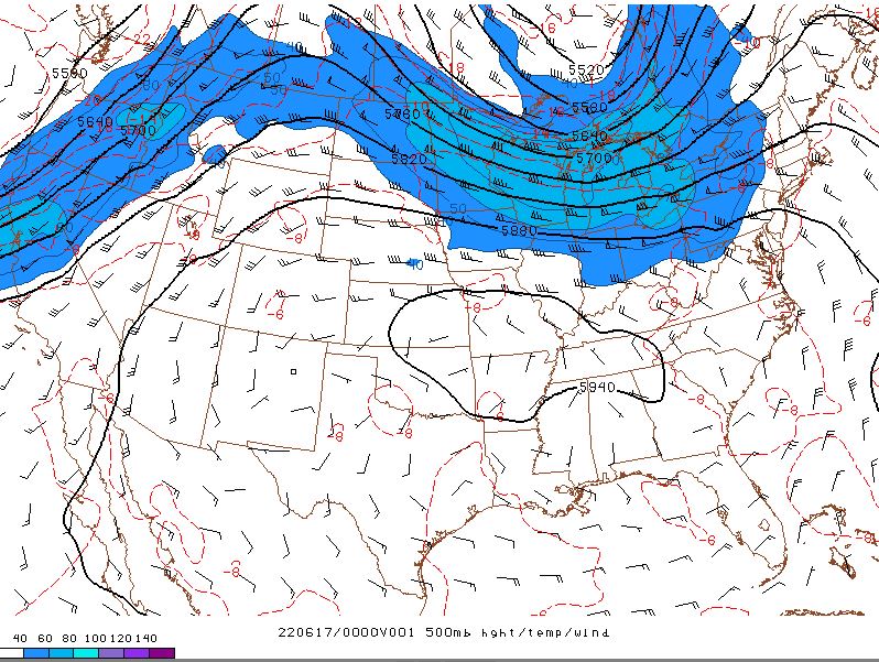
Upper Level Pattern
The graphics below show observed 500 mb heights, wind, and temperature. This shows the overall weather pattern approximately 20,000 feet above the surface. The higher heights are indicative of upper level ridging which originated in the southwest U.S. and built into the Tennessee and Ohio Valleys by June 14. As shortwave troughing progressed from the Northern Rockies into the Great Lakes, it squashed the ridge to the southern U.S. on June 16 and eventually repositioned it across the Central Plains by June 17-18.
 |
 |
| Valid 7 PM Sunday June 12 | Valid 7 PM Monday June 13 |
 |
 |
| Valid 7 PM Tuesday June 14 | Valid 7 PM Wednesday June 15 |
 |
|
| Valid 7 PM Tuesday June 16 |
 |
Media use of NWS Web News Stories is encouraged! Please acknowledge the NWS as the source of any news information accessed from this site. |
|

