Overview
Several rounds of thunderstorms occurred from the evening of the 2nd through the early morning hours of the 3rd. Rainfall rates were over an inch per hour in some of the storms, leading to storm total amounts of 3 to 5 inches in some locales in western Kentucky. Along and southeast of a line from Murray to Greenville and Central City., flash flooding caused vehicles to stall out, and an isolated water rescue or two was conducted. While rotation was observed in several of the storms across west Kentucky, only one confirmed tornado was documented.Tornadoes:
|
Tornado - Hopkinsville, KY
Track Map (click on map for larger size)  
|
||||||||||||||||
The Enhanced Fujita (EF) Scale classifies tornadoes into the following categories:
| EF0 Weak 65-85 mph |
EF1 Moderate 86-110 mph |
EF2 Significant 111-135 mph |
EF3 Severe 136-165 mph |
EF4 Extreme 166-200 mph |
EF5 Catastrophic 200+ mph |
 |
|||||
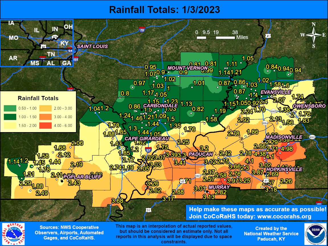
Flooding
Rainfall map for the event on Jan. 2-3, 2023
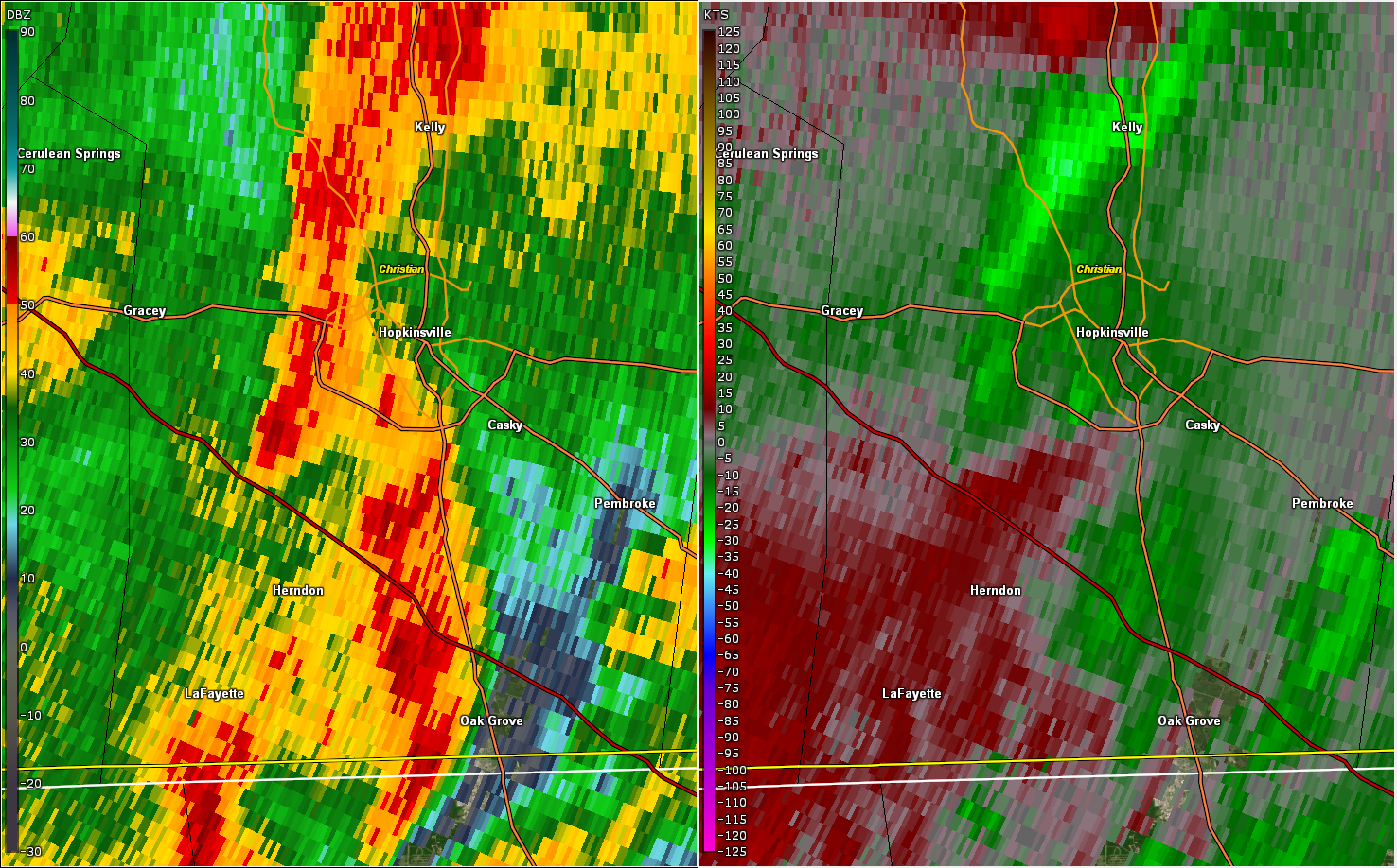
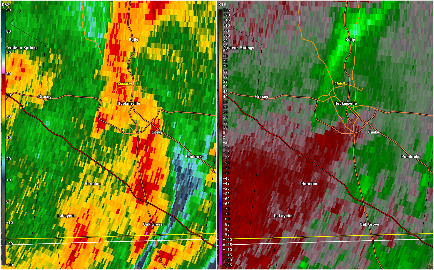
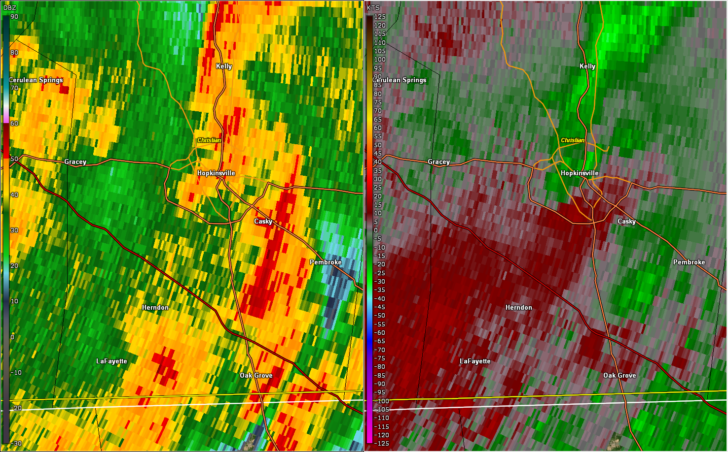
Radar Imagery
Regional scale: A 24-hour animated radar loop can be found here. Includes watch and warning polygons. Graphic courtesy of Iowa State.
Storm scale: Still images from the Paducah radar around the time of the Hopkinsville tornado. Click on images for larger size. Images generated with GR2Analyst software.
 |
 |
 |
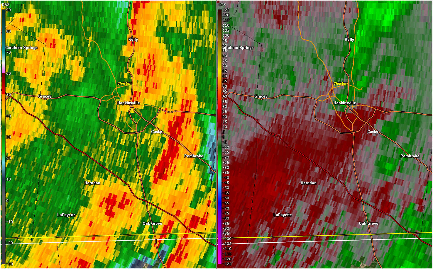 |
| Paducah radar 0.5 degree scan at 4:33 AM CST | Paducah radar 0.5 degree scan at 4:35 AM CST | Paducah radar 0.5 degree scan at 4:38 AM CST | Paducah radar 0.5 degree scan at 4:39 AM CST |
Storm Reports
PRELIMINARY LOCAL STORM REPORT...SUMMARY
NATIONAL WEATHER SERVICE PADUCAH KY
407 PM CST WED JAN 4 2023

..TIME...   ...EVENT...      ...CITY LOCATION...     ...LAT.LON...
..DATE...   ....MAG....      ..COUNTY LOCATION..ST.. ...SOURCE....
            ..REMARKS..

0958 PM     FLOOD            1 ENE BROOKPORT         37.13N 88.61W
01/02/2023                   MASSAC             IL   EMERGENCY MNGR

            2-3 INCHES OF WATER OVER UNIONVILLE RD.

1100 PM     FLOOD            PADUCAH                 37.07N 88.64W
01/02/2023                   MCCRACKEN          KY   EMERGENCY MNGR

            FLOODED ROADWAYS AT SEVERAL LOCATIONS IN THE
            PADUCAH AREA, MOSTLY FLOOD-PRONE UNDERPASSES
            AND LOW SPOTS.

1120 PM     TSTM WND DMG     1 NW FARIDEALING        36.86N 88.25W
01/02/2023                   MARSHALL           KY   EMERGENCY MNGR

            METAL CARPORT BLOWN INTO TREES.

1153 PM     HEAVY RAIN       2 SE HEATH              37.07N 88.77W
01/02/2023  M2.64 INCH       MCCRACKEN          KY   ASOS

            6-HOUR RAINFALL AT ASOS STATION KPAH PADUCAH KY.

0330 AM     TSTM WND DMG     3 WSW HAWKINS           37.02N 87.70W
01/03/2023                   CHRISTIAN          KY   EMERGENCY MNGR

            TREES DOWN ALONG PRINCETON ROAD, TIME
            ESTIMATED BY RADAR.

0425 AM     TSTM WND DMG     3 ENE HERNDON           36.73N 87.55W
01/03/2023                   CHRISTIAN          KY   PUBLIC

            TREES DOWN NEAR HERNDON. TIME ESTIMATED BY
            RADAR.

0435 AM     TORNADO          2 WSW HOPKINSVILLE      36.84N 87.53W
01/03/2023                   CHRISTIAN          KY   NWS STORM SURVEY

            A BRIEF EF-0 TORNADO WITH ESTIMATED PEAK
            WINDS OF 85 MPH STRUCK THE SOUTHWEST SIDE OF
            HOPKINSVILLE DURING THE PREDAWN HOURS OF
            TUESDAY, JANUARY 3RD. MOST OF THE DAMAGE WAS
            IN THE FORM OF SEVERAL LARGE SNAPPED TREE
            LIMBS. A CINDER BLOCK GARAGE ATTACHED TO A
            HOME OFF COX MILL ROAD HAD ITS ROOF REMOVED,
            WITH THE ADJACENT PORTION OF THE HOME HAVING
            A SMALL PORTION OF ITS ROOF REMOVED AS WELL.
            A LARGE CARPORT WAS LIFTED AND TOSSED AT
            LEAST 25 YARDS INTO A WOODED AREA NEAR
            WOODMONT DRIVE.

0443 AM     FLASH FLOOD      6 E MURRAY              36.62N 88.21W
01/03/2023                   CALLOWAY           KY   EMERGENCY MNGR

            FLOODING IN LOW LYING AREAS OF THE COUNTY.
            ONE PICKUP TRUCK STALLED IN FLOOD WATERS.

0447 AM     FLASH FLOOD      4 SW CADIZ              36.83N 87.87W
01/03/2023                   TRIGG              KY   LAW ENFORCEMENT

            FAIRLY WIDESPREAD FLOODING OF LOW LYING
            ROADS, SEVERAL ROADS CLOSED.

0456 AM     FLASH FLOOD      3 S CROFTON             37.00N 87.48W
01/03/2023                   CHRISTIAN          KY   EMERGENCY MNGR

            WATER OVER WILLIAM LILE ROAD AND IN A FEW
            OTHER PLACES THROUGH THE COUNTY.

0501 AM     TSTM WND DMG     4 N ELKTON              36.87N 87.16W
01/03/2023                   TODD               KY   LAW ENFORCEMENT

            TREES DOWN AT 181/LATHAM. TREES ALSO DOWN ON
            DEE ROAD.

0507 AM     FLASH FLOOD      1 ENE GREENVILLE        37.21N 87.16W
01/03/2023                   MUHLENBERG         KY   LAW ENFORCEMENT

            DISPATCH REPORTS A FEW WATER RESCUES, WATER
            IN A FEW RESIDENCES AND NUMEROUS ROADS
            CLOSED DUE TO FLOODING THROUGHOUT THE
            COUNTY.

0621 AM     HEAVY RAIN       3 SW GOLDON POND        36.78N 88.06W
01/03/2023  M4.98 INCH       TRIGG              KY   MESONET

            MESONET STATION LBLK2 GOLDEN POND KY.

0630 AM     HEAVY RAIN       4 WNW CERULEAN          36.98N 87.78W
01/03/2023  M3.82 INCH       CALDWELL           KY   MESONET

            MESONET STATION CBBK2 4.3 W CERULEAN.

0645 AM     HEAVY RAIN       4 SE ALLEGRE            36.88N 87.17W
01/03/2023  M3.43 INCH       TODD               KY   MESONET

            MESONET STATION DW3900 ELKTON KY.

0645 AM     HEAVY RAIN       6 S WOLF ISLAND         36.66N 89.20W
01/03/2023  M3.11 INCH       MISSISSIPPI        MO   MESONET

            MESONET STATION EW4994 DORENA MO.

0653 AM     HEAVY RAIN       2 SE HEATH              37.07N 88.77W
01/03/2023  M3.39 INCH       MCCRACKEN          KY   ASOS

            ASOS STATION KPAH PADUCAH KY.

0700 AM     HEAVY RAIN       3 NNW CROFTON           37.09N 87.50W
01/03/2023  M4.38 INCH       CHRISTIAN          KY   CO-OP OBSERVER

            CO-OP OBSERVER STATION CRFK2 CROFTON 3 N.

0700 AM     HEAVY RAIN       6 SSE AURORA            36.70N 88.10W
01/03/2023  M5.16 INCH       CALLOWAY           KY   MESONET

            MESONET STATION 1357D 5 SSE AURORA.

0700 AM     HEAVY RAIN       6 WSW GREENVILLE        37.16N 87.27W
01/03/2023  M4.98 INCH       MUHLENBERG         KY   COCORAHS

            COCORAHS STATION KY-MU-1 GREENVILLE 6.2 WSW.

0708 AM     FLASH FLOOD      4 ESE MURRAY            36.59N 88.26W
01/03/2023                   CALLOWAY           KY   PUBLIC

            CULVERT WASHED OUT ON OUTLAND SCHOOL ROAD
            NEAR OLD SALEM ROAD.

0714 AM     FLASH FLOOD      WISWELL                 36.58N 88.39W
01/03/2023                   CALLOWAY           KY   PUBLIC

            SIGNIFICANT FLOODING REPORTED ON CROSSLAND
            ROAD.
 |
Media use of NWS Web News Stories is encouraged! Please acknowledge the NWS as the source of any news information accessed from this site. |
|

