Overview
Severe thunderstorms impacted our region on Columbus Day 2014, with 6 tornadoes being confirmed.
Tornadoes:
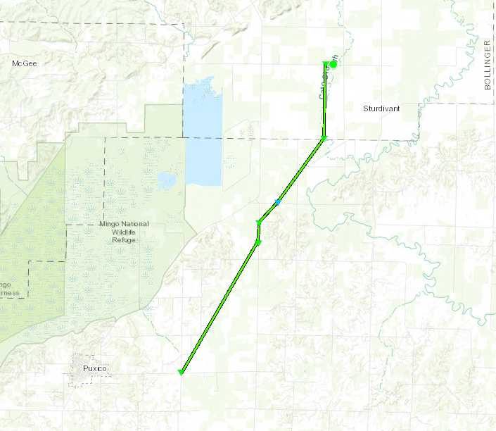
Tornado #1 - Puxico, Missouri
Stoddard & Bollinger Counties
| Date |
10/13/2014 |
| Time (CDT) |
1:30 PM - 1:43 PM |
| EF Rating |
EF-1 |
| Est. Peak Winds |
107 mph |
| Path Length |
9.5 miles |
| Max Width |
75 yards |
| Injuries/Deaths |
0/0 |
|
Summary: THE TORNADO MAINLY SNAPPED AND UPROOTED TREES ALONG THE PATH. TREE DAMAGE INCLUDED ONE TREE FALLING ON A HOME AND DOWNED POWER LINES.
|
Track Map
|
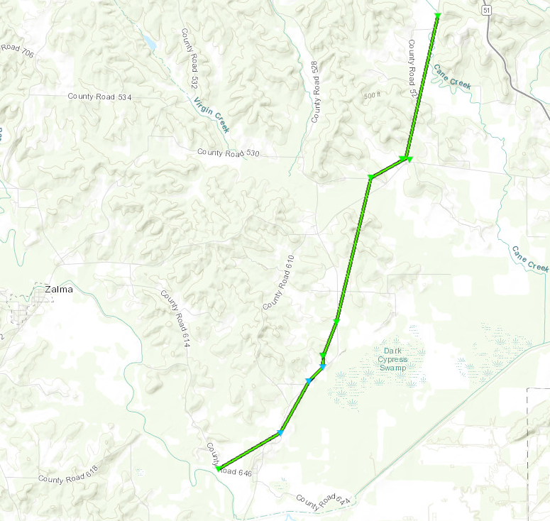
Tornado #2 - Zalma, Missouri
Bollinger County
| Date |
10/13/2014 |
| Time (CDT) |
1:45 PM - 1:58 PM |
| EF Rating |
EF-1 |
| Est. Peak Winds |
107 mph |
| Path Length |
7 miles |
| Max Width |
100 yards |
| Injuries/Deaths |
0/0 |
|
Summary: THE TORNADO DESTROYED TWO SMALL BARNS AND A FEW SILOS. A MOBILE HOME WAS SHIFTED OFF ITS FOUNDATION. A HOUSE NEXT TO THE MOBILE HOME HAD ITS PORCH BLOWN OVER THE HOUSE. ANOTHER HOUSE HAD A CARPORT THAT COLLAPSED AND FELL ON VEHICLES. A THIRD HOME SUSTAINED DAMAGE MAINLY TO WINDOWS. OTHERWISE NUMEROUS TREES SNAPPED WERE SNAPPED AND UPROOTED ALONG THE PATH.
|
Track Map
|
Tornado #3 - Leopold, Missouri
Bollinger County
| Date |
10/13/2014 |
| Time (CDT) |
2:02 PM - 2:03 PM |
| EF Rating |
EF-1 |
| Est. Peak Winds |
93 mph |
| Path Length |
2 miles |
| Max Width |
50 yards |
| Injuries/Deaths |
0/0 |
|
Summary: THE TORNADO DAMAGED A FEW BARNS, THROWING DEBRIS ACROSS A YARD AND BUCKLING ONE BARN ROOF. SEVERAL TREES WERE UPROOTED AND SNAPPED ALONG THE PATH.
|
Track Map
.png)
|
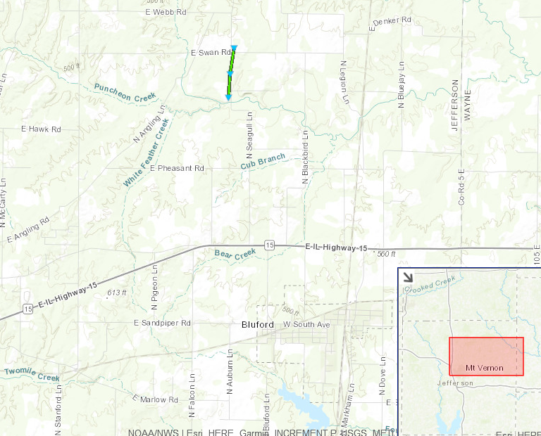
Tornado #4 - Bluford, Illinois
Jefferson County
| Date |
10/13/2014 |
| Time (CDT) |
4:07 PM - 4:08 PM |
| EF Rating |
EF-1 |
| Est. Peak Winds |
105 mph |
| Path Length |
0.5 miles |
| Max Width |
50 yards |
| Injuries/Deaths |
0/0 |
|
Summary: THE TORNADO BRIEFLY TOUCHED DOWN ALONG NORTH SEAGULL LANE AND BROUGHT DOWN POWER LINES ALONG THE ROAD. A BARN WAS DAMAGED WITH ITS METAL ROOF PEELED TOWARD THE NORTH. THE TORNADO DAMAGED THE ROOF OF A HOUSE AND DESTROYED A BARN. METAL CHAIRS WERE PUSHED UP ALONG A RAILING NEAR THE HOUSE. TREES WERE SNAPPED AND UPROOTED.
|
Track Map
|
Tornado #5 - Dix, Illinois
Jefferson County
| Date |
10/13/2014 |
| Time CDT) |
4:06 PM - 4:10 PM |
| EF Rating |
EF-1 |
| Est. Peak Winds |
105 mph |
| Path Length |
2.5 miles |
| Max Width |
100 yards |
| Injuries/Deaths |
0/0 |
|
Summary: The tornado first touched down just northeast of Dix, snapping a couple of trees and downing large limbs. The tornado moved northeast, uprooting a tree and damaging some others. At a residence at the end of County Road 2330, shingles were blown off a mobile home, several trees were uprooted, and patio furniture was thrown about 25 yards in all directions. This residence is where the strongest winds occurred, estimated near 105 mph. The tornado downed corn, broke large tree limbs, and uprooted a large oak tree as it crossed County Road 32 from Jefferson County into Marion County.
|
Track Map
.png)
|
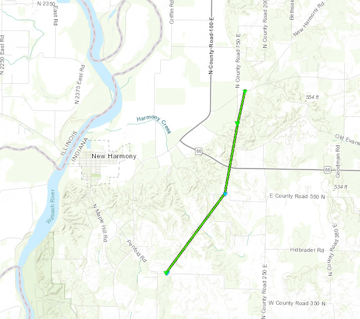
Tornado #6 - New Harmony, Indiana
Posey County
| Date |
10/13/2014 |
| Time (CDT) |
5:31 PM - 5:42 PM |
| EF Rating |
EF-1 |
| Est. Peak Winds |
100 mph |
| Path Length |
5 miles |
| Max Width |
150 yards |
| Injuries/Deaths |
0/0 |
|
Summary:
|
Track Map
|
The Enhanced Fujita (EF) Scale classifies tornadoes into the following categories:
EF0
Weak
65-85 mph |
EF1
Moderate
86-110 mph |
EF2
Significant
111-135 mph |
EF3
Severe
136-165 mph |
EF4
Extreme
166-200 mph |
EF5
Catastrophic
200+ mph |
 |


