Excessive rainfall may produce locally considerable flash flooding over parts of South Texas, the western Gulf Coast, and Lower Mississippi River Valley through Thursday. Hot temperatures will persist over central and northern California and the Pacific Northwest through today. Read More >
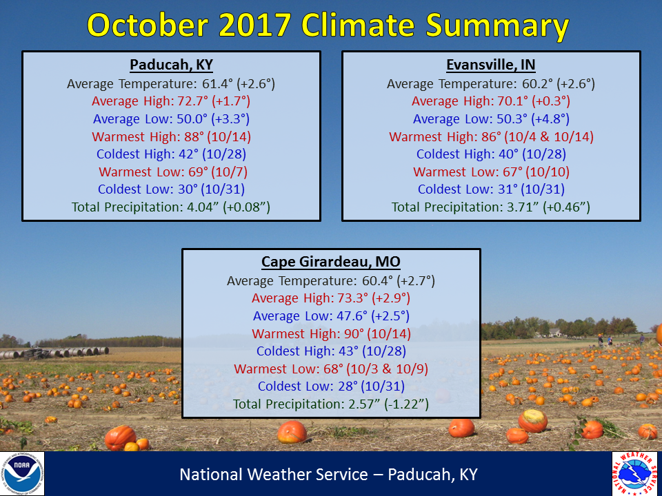
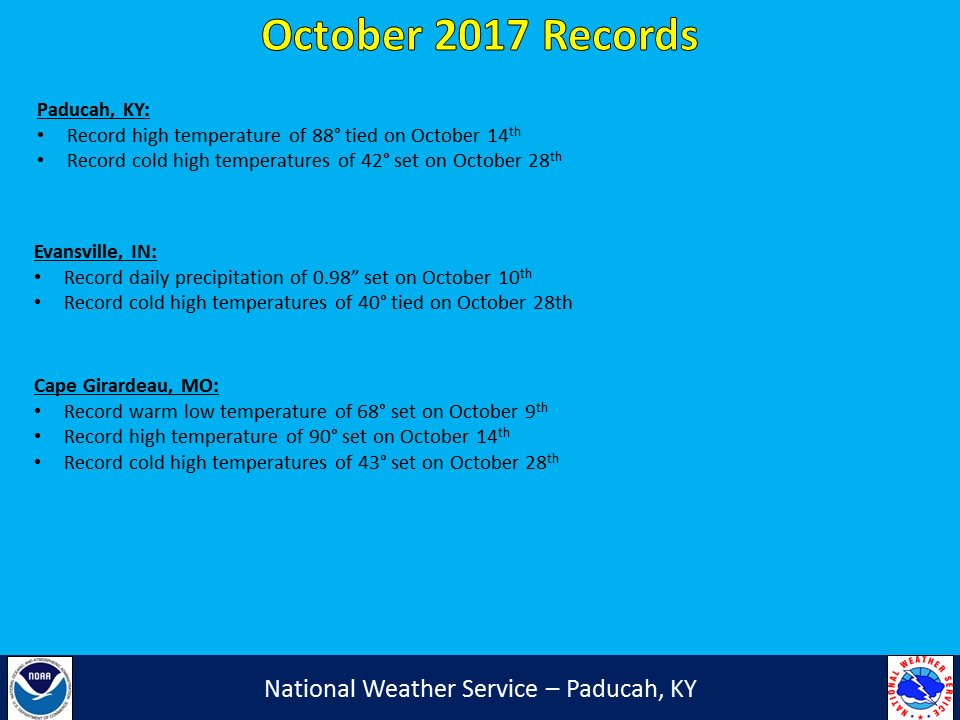
Temperatures were above normal, generally by 2 to 3 degrees. The first half of the month was well above normal, with highs routinely in the 80s. You may not remember that warm weather though, because the last 4 days of the month were well below normal, which helped to lower the overall monthly average temperature. In fact, the high temperature on Halloween was the coldest since 1993 in Evansville, IN and 2002 in Paducah, KY and Cape Girardeau, MO. Highs will typically warm into the 60s on Halloween, but were stuck in the upper 40s to lower 50s this year. Our first freeze of the season occurred on October 25th in Cape Girardeau, October 28th in Paducah and October 29th in Evansville. This was right around the average date for the season’s first freeze.
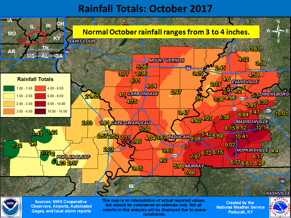
Precipitation varied across the region, ranging from excessively wet across the Pennyrile region of west Kentucky to excessively dry in the Ozark Foothills of Missouri. Rainfall amounts of 8-10+ inches occurred in portions of Christian, Hopkins, and Muhlenberg Counties in Kentucky. The highest reported amount was at the Kentucky Mesonet station north of Greenville which recorded 12.16”! (Long time records aren’t available at this station, but for comparison the wettest October on record in Paducah only received 10.55” of rain back in 2009 and the wettest October in Evansville was 11.19” back in 1910.) Above normal rainfall also occurred across much of southwest Indiana and along the Interstate 57 corridor in Illinois from Cairo to Mount Vernon and also into Wayne County. Another month of abnormally dry conditions in the Ozark Foothills resulted in moderate drought conditions developing, encompassing our 6 western counties. The drier conditions also resulted in a greater diurnal temperature swing occurring at Cape Girardeau, compared to Paducah and Evansville. Larger temperature swings from highs to lows are common in drier regions of the country, because more of the sun’s energy is focused on heating up the surface rather than evaporating moisture from it. Drier ground conditions can also lead to cooler night time temperatures.
| October 2017 Review: Precipitation and Temperature Maps (Click on image to enlarge) |
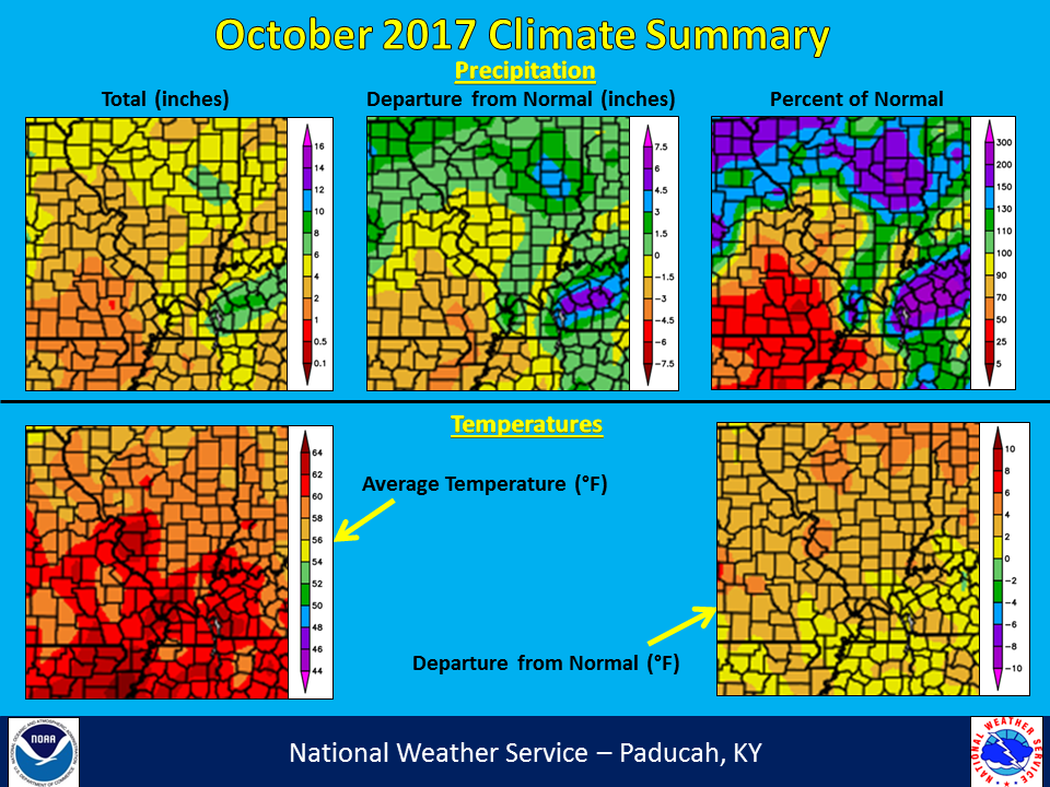 |
| Climate Maps are from the Northeast Regional Climate Center |
The graphic below is an interpolated rainfall map using actual observations. Please note that there are likely discrepancies in between observations, since the values are estimated based on nearest reports. Due to the convective nature of rainfall in the warmer months, amounts are more likely to vary over shorter distances, compared to the cooler months.
 |