The graphic below shows observed snowfall totals, along with estimated snowfall amounts in-between actual observations. There is a table located below the map, that shows the amount and location of snowfall totals.
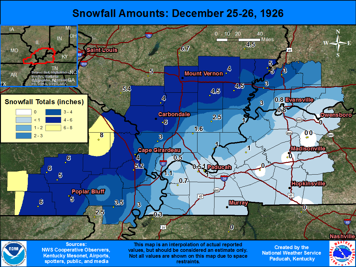
| State | Location | Type | County | Snow |
| MO | PATTON | COOP | Bollinger | 8 |
| MO | DONIPHAN | COOP | Ripley | 6 |
| MO | GREENVILLE 6 N | COOP | Wayne | 6 |
| MO | LEEPER | COOP | Wayne | 6 |
| IL | CARBONDALE SEWAGE PLT | COOP | Jackson | 6 |
| IL | MT VERNON 3 NE | COOP | Jefferson | 6 |
| MO | BENTON | COOP | Scott | 5.2 |
| MO | POPLAR BLUFF | COOP | Butler | 5 |
| MO | WILLIAMSVILLE | COOP | Wayne | 5 |
| IL | MT CARMEL | COOP | Wabash | 5 |
| IL | MT CARMEL 4 NW | COOP | Wabash | 5 |
| IL | MCLEANSBORO | COOP | Hamilton | 4.5 |
| IL | CARMI 6 NW | COOP | White | 4.5 |
| MO | CAPE GIRARDEAU | COOP | Cape Girardeau | 4 |
| IL | DU QUOIN 4 SE | COOP | Perry | 4 |
| IL | FAIRFIELD RADIO WFIW | COOP | Wayne | 4 |
| MO | PARMA | COOP | New Madrid | 3.5 |
| MO | NEW MADRID | COOP | New Madrid | 3 |
| IL | ANNA | COOP | Union | 3 |
| IN | MT VERNON | COOP | Posey | 3 |
| IN | STEWARTSVILLE | COOP | Posey | 3 |
| IN | PRINCETON 1 W | COOP | Gibson | 3 |
| MO | DEXTER | COOP | Stoddard | 2.5 |
| IL | HARRISBURG | COOP | Saline | 2.5 |
| IL | NEW BURNSIDE | COOP | Johnson | 1.6 |
| IL | CAIRO | WBAN | Alexander | 1.1 |
| KY | PADUCAH RIVER | COOP | McCracken | 1 |
| KY | PADUCAH | COOP | McCracken | 1 |
| IL | GOLCONDA RIVER | COOP | Pope | 1 |
| IL | SHAWNEETOWN OLD TOWN | COOP | Gallatin | 1 |
| KY | MARION | COOP | Crittenden | 1 |
| IN | CYPRESS DAM 48 | COOP | Vanderburgh | 0.8 |
| IN | EVANSVILLE FT COUR | COOP | Vanderburgh | 0.8 |
| KY | BLANDVILLE | COOP | Ballard | 0.7 |
| IL | GRAND CHAIN DAM 53 | COOP | Pulaski | 0.5 |
| KY | PADUCAH LONE OAKS | COOP | McCracken | 0.5 |

