Paducah, KY
Weather Forecast Office
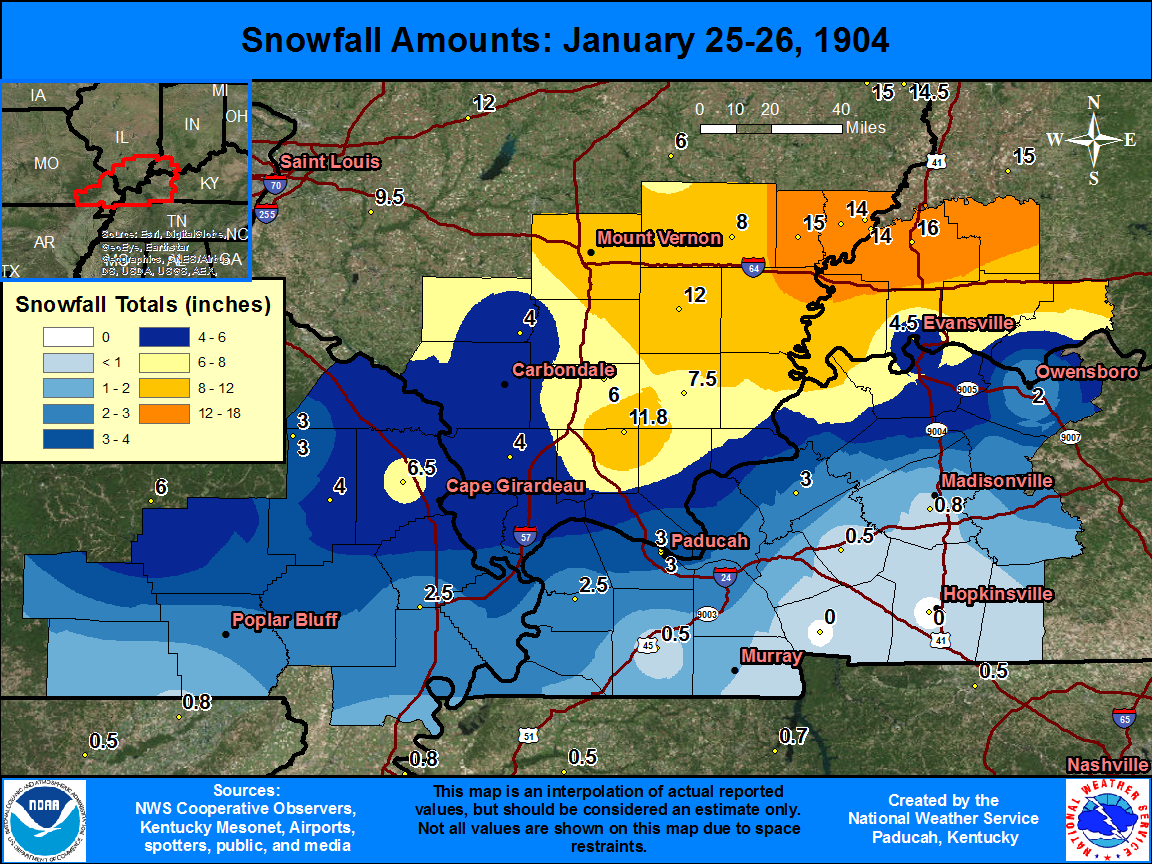
The graphic below shows observed snowfall totals, along with estimated snowfall amounts in-between actual observations. There is a table located below the map, that shows the amount and location of snowfall totals.
| State | Location | Type | County | Snow |
| IN | PRINCETON 1 W | COOP | Gibson | 16 |
| IL | ALBION | COOP | Edwards | 15 |
| IL | MT CARMEL | COOP | Wabash | 14 |
| IL | MT CARMEL 4 NW | COOP | Wabash | 14 |
| IL | FRIEND GROVE | COOP | Wabash | 14 |
| IL | MCLEANSBORO | COOP | Hamilton | 12 |
| IL | NEW BURNSIDE | COOP | Johnson | 11.8 |
| IL | MT VERNON 3 NE | COOP | Jefferson | 10 |
| IL | FAIRFIELD RADIO WFIW | COOP | Wayne | 8 |
| IL | HARRISBURG | COOP | Saline | 7.5 |
| MO | JACKSON | COOP | Cape Girardeau | 6.5 |
| IL | HALFWAY | COOP | Williamson | 6 |
| IN | EVANSVILLE FT COUR | COOP | Vanderburgh | 4.5 |
| MO | MARBLE HILL | COOP | Bollinger | 4 |
| IL | ANNA | COOP | Union | 4 |
| IL | DU QUOIN 4 SE | COOP | Perry | 4 |
| MO | PINE HILL | COOP | Bollinger | 3 |
| KY | PADUCAH RIVER | COOP | McCracken | 3 |
| KY | PADUCAH | COOP | McCracken | 3 |
| KY | MARION | COOP | Crittenden | 3 |
| MO | SIKESTON | COOP | New Madrid | 2.5 |
| KY | BLANDVILLE | COOP | Ballard | 2.5 |
| KY | OWENSBORO | COOP | Daviess | 2 |
| KY | EARLINGTON | COOP | Hopkins | 0.8 |
| KY | MAYFIELD 2 S | COOP | Graves | 0.5 |
| KY | PRINCETON | COOP | Caldwell | 0.5 |
FORECASTS
Forecast Discussion
User Defined Area Forecast
Hourly Forecasts
Fire Weather
Activity Planner
LOCAL INFORMATION
Aviation Weather
Our Office
SKYWARN
Items of Interest
Hazardous Weather Support
Local Observations
Weather History
NWS Paducah KY Weekly Partner Briefing
US Dept of Commerce
National Oceanic and Atmospheric Administration
National Weather Service
Paducah, KY
8250 Kentucky Highway 3520
West Paducah, KY 42086-9762
270-744-6440
Comments? Questions? Please Contact Us.

