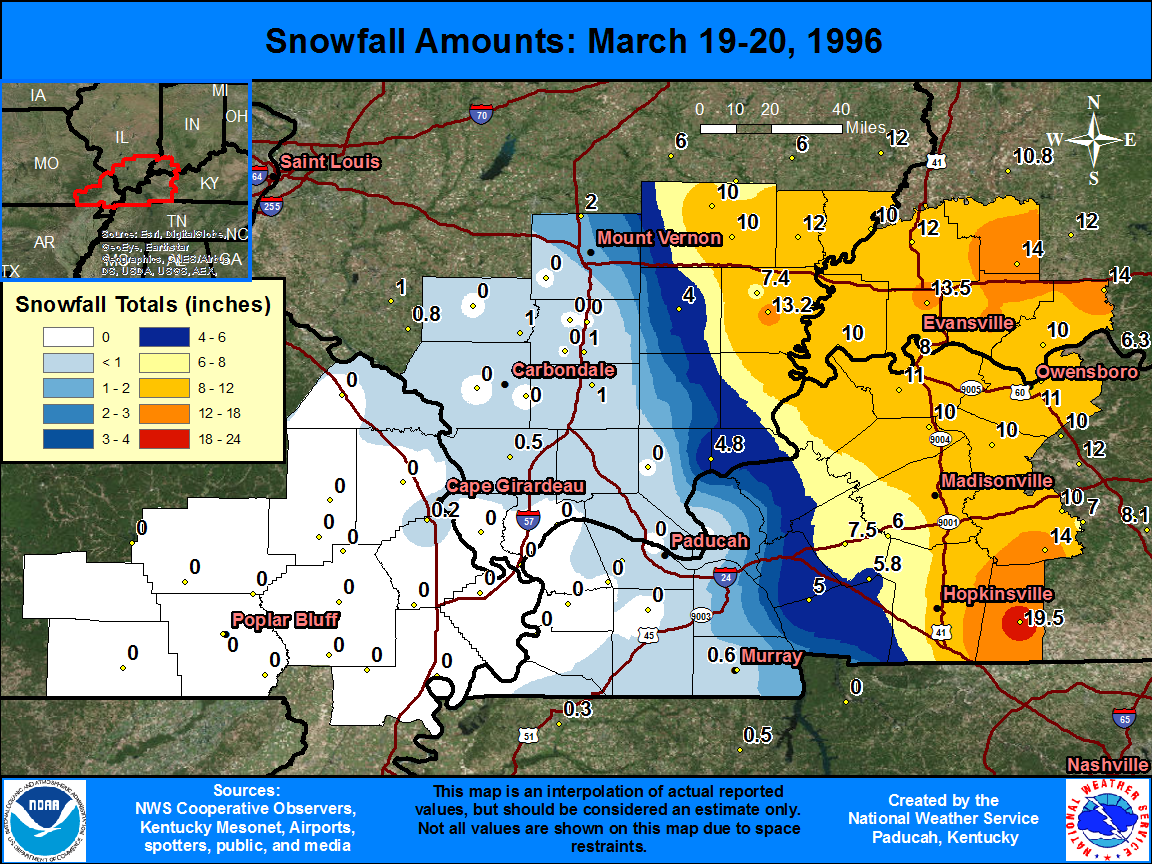
The graphic below shows observed snowfall totals, along with estimated snowfall amounts in-between actual observations. There is a table located below the map, that shows the amount and location of snowfall totals.
| State | Location | Type | County | Snow |
| KY | ELKTON | COOP | Todd | 19.5 |
| KY | BELTON 6 SW | COOP | Muhlenberg | 14 |
| IN | SAINT MEINRAD | COOP | Spencer | 14 |
| IN | STENDAL | COOP | Pike | 14 |
| IN | MCCUTCHANVILLE 4 N | COOP | Vanderburgh | 13.5 |
| IL | CARMI 3 | COOP | White | 13.2 |
| IN | BOONVILLE 1 S | COOP | Warrick | 12.2 |
| IN | PRINCETON 1 W | COOP | Gibson | 12 |
| IL | ALBION | COOP | Edwards | 12 |
| KY | HENDERSON 8 SSW | COOP | Henderson | 11 |
| KY | OWENSBORO 3E | COOP | Daviess | 11 |
| KY | CALHOUN LOCK 2 | COOP | McLean | 10 |
| KY | SEBREE 1 E | COOP | Webster | 10 |
| IL | MT CARMEL | COOP | Wabash | 10 |
| KY | PARADISE STEAM PLT | COOP | Muhlenberg | 10 |
| IN | ROCKPORT 4 N | COOP | Spencer | 10 |
| IN | MT VERNON | COOP | Posey | 10 |
| IL | FAIRFIELD RADIO WFIW | COOP | Wayne | 10 |
| IL | CISNE 2 S | COOP | Wayne | 10 |
| IN | EVANSVILLE REGIONAL AP | WBAN | Vanderburgh | 9.6 |
| IN | EVANSVILLE MUSEUM | COOP | Vanderburgh | 8 |
| KY | PRINCETON 1 SE | COOP | Caldwell | 7.5 |
| IL | CARMI 6 NW | COOP | White | 7.4 |
| KY | DAWSON SPRINGS | COOP | Hopkins | 6 |
| KY | COBB | COOP | Caldwell | 5.8 |
| KY | GOLDEN POND 8 N | COOP | Trigg | 5 |
| IL | ROSICLARE 5 NW | COOP | Hardin | 4.8 |
| IL | MCLEANSBORO | COOP | Hamilton | 4 |
| IL | DIX | COOP | Jefferson | 2 |
| IL | MT VERNON 3 NE | COOP | Jefferson | 2 |
| IL | MARION 4 NNE | COOP | Williamson | 1 |
| IL | WEST FRANKFORT | COOP | Franklin | 1 |
| IL | DU QUOIN 4 SE | COOP | Perry | 1 |
| KY | PADUCAH BARKLEY RGNL AP | WBAN | McCracken | 0.8 |
| KY | MURRAY | COOP | Calloway | 0.6 |
| IL | ANNA | COOP | Union | 0.5 |
| MO | CAPE GIRARDEAU MUNI AP | WBAN | Scott | 0.2 |

