Top 10 Weather Headlines of 2002
The 2002 spring severe weather season will long be remembered for a series of destructive tornado outbreaks in late April. Three fatalities and over a hundred injuries occurred. The first F-4 tornado in our county warning area since the early 1990's struck near Poplar Bluff, Missouri on April 24. Flooding and droughts both made news headlines in 2002. Major flooding on the Mississippi River in May inundated many thousands of acres of cropland, and flash flooding took one life in Marble Hill, Missouri. Severe drought conditions then set in during the summer, and crop damage totals across our region topped those of the 1999 drought. Winter weather made an appearance before the year was out, with a major snow and ice storm on December 4. Overall, the year 2002 was a busy weather year.
The rankings below are based mostly on damage figures and casualties.
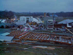
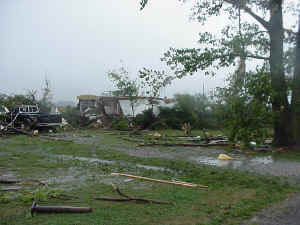
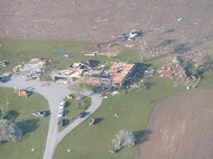 1. Late April Tornadoes - killed three and injured over 100. A long-track tornado across Carter and Butler Counties in Missouri produced F-4 damage near Poplar Bluff. A tornado in Wayne County, Illinois took one life on April 21. Two more lives were lost during a tornado outbreak in the wee morning hours of April 28, one near Marble Hill, Missouri and another near Dongola, Illinois. A tornado destroyed parts of Providence, Kentucky but caused no loss of life. 1. Late April Tornadoes - killed three and injured over 100. A long-track tornado across Carter and Butler Counties in Missouri produced F-4 damage near Poplar Bluff. A tornado in Wayne County, Illinois took one life on April 21. Two more lives were lost during a tornado outbreak in the wee morning hours of April 28, one near Marble Hill, Missouri and another near Dongola, Illinois. A tornado destroyed parts of Providence, Kentucky but caused no loss of life. |
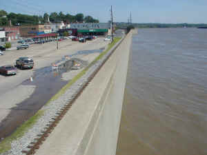 2 . Mississippi River flooding in May - The fourth highest river stage on record occurred at Cape Girardeau. Widespread flooding of farmland occurred. Rural areas not protected by levees or floodwalls were inundated. Flash flooding preceding the river flooding took one life near Marble Hill, Missouri. 2 . Mississippi River flooding in May - The fourth highest river stage on record occurred at Cape Girardeau. Widespread flooding of farmland occurred. Rural areas not protected by levees or floodwalls were inundated. Flash flooding preceding the river flooding took one life near Marble Hill, Missouri. |
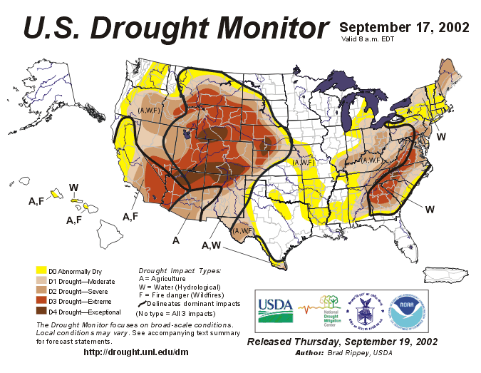 3. Severe Summer Drought - Farmers planted their crops late due to excessively wet fields in the spring, only to find their crops wilting in intense heat and dry soil during the summer. Crop loss estimates exceeded those of the 1999 drought, which was more severe but much more limited in areal extent. The widespread nature of this drought and its timing were the main factors in the high crop damage figures. 3. Severe Summer Drought - Farmers planted their crops late due to excessively wet fields in the spring, only to find their crops wilting in intense heat and dry soil during the summer. Crop loss estimates exceeded those of the 1999 drought, which was more severe but much more limited in areal extent. The widespread nature of this drought and its timing were the main factors in the high crop damage figures. |
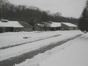 4. Major Winter Storm on December 4 - Up to 9 inches of snow and 1 inch of ice caused widespread travel problems. Serious icing in the Tennessee border counties of western Kentucky caused numerous power outages lasting up to three days. Schools and businesses were shut down, and at least two fatal vehicle accidents occurred. 4. Major Winter Storm on December 4 - Up to 9 inches of snow and 1 inch of ice caused widespread travel problems. Serious icing in the Tennessee border counties of western Kentucky caused numerous power outages lasting up to three days. Schools and businesses were shut down, and at least two fatal vehicle accidents occurred. |
 5. Tornado at Calhoun, KY on Jan. 23 - A tornado struck the north side of Calhoun, KY, during the late evening hours. Around one million dollars in damage occurred, but there were no deaths or known injuries. The tornado was rated F-2 in intensity. 5. Tornado at Calhoun, KY on Jan. 23 - A tornado struck the north side of Calhoun, KY, during the late evening hours. Around one million dollars in damage occurred, but there were no deaths or known injuries. The tornado was rated F-2 in intensity. |
 6. Poseyville, IN Tornado on Sept. 20 - A tornado struck rural areas just outside of Poseyville, Indiana during the late morning hours, destroying several buildings and about 10 mobile homes. The F-2 tornado caused one minor injury during its 5-mile path. The storm that produced this tornado eventually went on to produce many others as it moved northeast across central Indiana. 6. Poseyville, IN Tornado on Sept. 20 - A tornado struck rural areas just outside of Poseyville, Indiana during the late morning hours, destroying several buildings and about 10 mobile homes. The F-2 tornado caused one minor injury during its 5-mile path. The storm that produced this tornado eventually went on to produce many others as it moved northeast across central Indiana. |
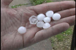
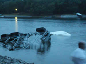 7. Thunderstorm Microburst at Kentucky Lake on July 10 - About a dozen homes on the west shore of Kentucky Lake in Marshall County received substantial damage from a localized thunderstorm microburst. Damage to boat docks and boats was extensive. There was a weak tornado embedded in the microburst. 7. Thunderstorm Microburst at Kentucky Lake on July 10 - About a dozen homes on the west shore of Kentucky Lake in Marshall County received substantial damage from a localized thunderstorm microburst. Damage to boat docks and boats was extensive. There was a weak tornado embedded in the microburst. |
 8. Severe Weather Event on November 10 - A major tornado outbreak struck the Ohio and Tennessee Valleys on this day, however, the Paducah county warning area was west of the most destructive weather. A couple of weak tornadoes occurred in southern Illinois, producing no significant damage. Large hail and isolated reports of wind damage were the main effects of this weather system. 8. Severe Weather Event on November 10 - A major tornado outbreak struck the Ohio and Tennessee Valleys on this day, however, the Paducah county warning area was west of the most destructive weather. A couple of weak tornadoes occurred in southern Illinois, producing no significant damage. Large hail and isolated reports of wind damage were the main effects of this weather system. |
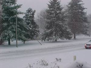 9. Winter Storm in Southern Illinois on December 24 - A Christmas Eve snow and ice storm dumped up to 8 inches of snow from Perryville, Missouri to Carbondale and Mount Vernon, Illinois. The significant snow and ice accumulations stayed mainly north of the Ohio River and north of Cape Girardeau. 9. Winter Storm in Southern Illinois on December 24 - A Christmas Eve snow and ice storm dumped up to 8 inches of snow from Perryville, Missouri to Carbondale and Mount Vernon, Illinois. The significant snow and ice accumulations stayed mainly north of the Ohio River and north of Cape Girardeau. |
 10. Severe Weather Event on March 29 - Numerous reports of large hail, along with isolated strong wind gusts, were received east of the Mississippi River. 10. Severe Weather Event on March 29 - Numerous reports of large hail, along with isolated strong wind gusts, were received east of the Mississippi River. |
|
Have a safe and happy 2003! |

