Overview
A line of showers and thunderstorms raced east-northeast across western Kentucky and southwest Indiana, producing pockets of damaging wind and a couple of brief tornadoes.Tornadoes:
|
Tornado #1 - East of Mariah Hill Indiana
Track Map %2012-31-18.png) 
|
||||||||||||||||
|
Tornado #2 - Blue Water Estates Kentucky
Track Map %2012-31-18.png)
|
||||||||||||||||
The Enhanced Fujita (EF) Scale classifies tornadoes into the following categories:
| EF0 Weak 65-85 mph |
EF1 Moderate 86-110 mph |
EF2 Significant 111-135 mph |
EF3 Severe 136-165 mph |
EF4 Extreme 166-200 mph |
EF5 Catastrophic 200+ mph |
 |
|||||
Wind Overview:
The primary severe weather event type was wind. In addition to thunderstorm winds, there were strong gusty non-thunderstorm winds associated with a deepening low pressure system over the mid Mississippi Valley. Please check the "non-thunderstorm winds" tab of this web summary for more information. Little or no hail was associated with the storms.
Wind (details)
The line of showers and thunderstorms produced the first couple of microbursts in extreme western Kentucky in Paducah and Graves County. Damaging winds became more frequent as the line moved east across the Murray, Cadiz, and Hopkinsville areas. Pockets of tree damage were reported across Calloway, Trigg, Christian, Todd, and Muhlenberg Counties. NWS damage surveys concluded there were a couple of isolated tornadoes, including one in northeast Spencer County, Indiana and a second in Trigg County, KY.
The following are the results of two damage surveys conducted on Monday, December 31:
1. PADUCAH, KY............
Public Information Statement
National Weather Service Paducah, KY
845 PM CST Mon Dec 31 2018

...NWS DAMAGE SURVEY FOR 12/31/2018 MCCRACKEN COUNTY KY
MICROBURST...

Peak wind /Estimated/:   80 mph
Path length /Statute/:   1.0 mile
Path width /Maximum/:    0.6 mile
Fatalities:              Zero
Injuries:                Zero

Start date:              12/31/2018
Start time:              11:47 AM CST
Start location:          4 miles W of downtown Paducah, KY
                         (just east of intersection of
                         Cairo Rd. and Interstate 24)

End date:                12/31/2018
End time:                11:48 AM CST
End location:            3.5 miles NW of downtown Paducah, KY
                         (just north of Cairo Rd. and
                         Noble Rd. intersection)

SURVEY_SUMMARY: The damage was generally along and north of Cairo
Rd. and east of Interstate 24. Loss of metal siding or roofing
occurred on at least three businesses, and loss of shingles
occurred on at least one home. An HVAC unit was dislodged atop
Rural King. Metal fencing was blown off a business on Moody Rd.
Several trees or tree limbs were broken or uprooted, and two power
and security light poles were damaged or blown over.

NOTE:
The information in this statement is PRELIMINARY and subject to
change pending final review of the event and publication in NWS
Storm Data.
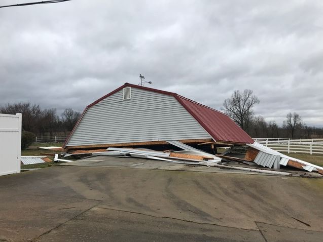
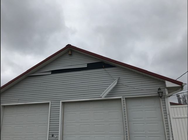
2. GRAVES COUNTY, KY (SYMSONIA AREA)............
Public Information Statement
National Weather Service Paducah, KY
658 PM CST Mon Dec 31 2018

...NWS DAMAGE SURVEY FOR 12/31/2018 GRAVES COUNTY KY THUNDERSTORM
WIND EVENT...

Peak wind /Estimated/:   75 mph
Path length /Statute/:   1.0 mile
Path width /Maximum/:    0.4 mile
Fatalities:              Zero
Injuries:                Zero

Start date:              12/31/2018
Start time:              11:52 AM CST
Start location:          5 miles SW Symsonia, KY

End date:                12/31/2018
End time:                11:53 AM CST
End location:            4.5 miles W Symsonia, KY

SURVEY_SUMMARY: Straight line thunderstorm winds damaged at least
three buildings, including the lifting of the roof structure from
a carport. Several tree limbs were broken.

NOTE:
The information in this statement is PRELIMINARY and subject to
change pending final review of the event and publication in NWS
Storm Data.
Non-thunderstorm winds:
Following the passage of the line of showers and storms, winds increased again from the west-southwest. There were several gusts around 40 mph late in the afternoon.
The following are reports of strong winds that were not associated with thunderstorms:
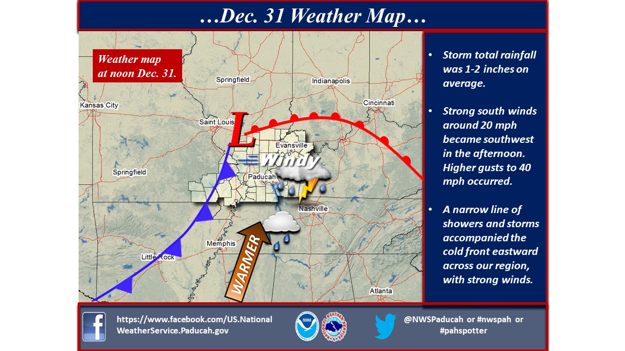
Below is the weather map for Monday, Dec. 31 at noon.
Photos
Damage survey pictures
 |
 |
| West of Symsonia, KY microburst (NWS photo) |
West of Symsonia, KY (NWS photo) |
Storm Reports
PRELIMINARY LOCAL STORM REPORT...SUMMARY
NATIONAL WEATHER SERVICE PADUCAH KY
1033 PM CST MON DEC 31 2018

..TIME...   ...EVENT...      ...CITY LOCATION...     ...LAT.LON...
..DATE...   ....MAG....      ..COUNTY LOCATION..ST.. ...SOURCE....
            ..REMARKS..

1146 AM     TSTM WND DMG     6 N METROPOLIS          37.24N 88.71W
12/31/2018                   MASSAC             IL   PUBLIC

            A LARGE OAK TREE FELL ACROSS A DRIVEWAY 1
            MILE SOUTH OF ROUND KNOB.

1147 AM     DOWNBURST        4 W PADUCAH             37.10N 88.68W
12/31/2018                   MCCRACKEN          KY   NWS STORM SURVEY

            NWS DAMAGE SURVEY FOUND THAT A MICROBURST
            WITH ESTIMATED PEAK WINDS OF 80 MPH OCCURRED
            IN PADUCAH. THE EVENT BEGAN AT 11:47 AM CST
            ABOUT 4 MILES W OF DOWNTOWN PADUCAH (JUST
            EAST OF THE INTERSECTION OF CAIRO RD. AND
            I-24) AND ENDED AT 11:48 AM CST 3.5 MILES NW
            OF DOWNTOWN PADUCAH (JUST NORTH OF THE
            INTERSECTION OF CAIRO RD. AND NOBLE RD.).
            THE DAMAGE WAS GENERALLY ALONG AND NORTH OF
            CAIRO RD. AND EAST OF I-24. LOSS OF METAL
            SIDING OR ROOFING OCCURRED ON AT LEAST THREE
            BUSINESSES AND AT LEAST ONE HOME. AN HVAC
            UNIT WAS DISLODGED ATOP RURAL KING. METAL
            FENCING WAS BLOWN OFF A BUSINESS ON MOODY
            RD. SEVERAL TREES OR TREE LIMBS WERE BROKEN
            OR DAMAGED, AND TWO POWER AND SECURITY LIGHT
            POLES WERE DAMAGED OR BLOWN OVER.

1147 AM     TSTM WND DMG     2 NW PADUCAH            37.09N 88.66W
12/31/2018                   MCCRACKEN          KY   PUBLIC

            ROOF DAMAGE REPORTED AT THE RURAL KING
            INCLUDING AN AC UNIT THAT WAS TORN OFF THE
            ROOF.

1152 AM     TSTM WND DMG     5 SW SYMSONIA           36.86N 88.57W
12/31/2018                   GRAVES             KY   NWS STORM SURVEY

            NWS DAMAGE SURVEY FOUND STRAIGHT LINE WIND
            DAMAGE WITH ESTIMATED PEAK WINDS OF 75 MPH.
            THE DAMAGE STARTED AT 11:52 AM CST 5 MILES
            SW OF SYMSONIA, KY, AND ENDED AT 11:53 AM
            CST 4.5 MILES W OF SYMSONIA, KY. THE DAMAGE
            PATH WAS 1 MILE IN LENGTH WITH A MAXIMUM
            PATH WIDTH OF 0.4 MILES. AT LEAST THREE
            BUILDINGS WERE DAMAGED, INCLUDING THE ROOF
            STRUCTURE BEING LIFTED OFF A CARPORT.
            SEVERAL TREES OR TREE LIMBS WERE BROKEN.

1154 AM     TSTM WND DMG     4 W SYMSONIA            36.90N 88.58W
12/31/2018                   GRAVES             KY   EMERGENCY MNGR

            SIGNIFICANT DAMAGE TO A BARN ON KY 994
            ACROSS FROM THE NORTH GRAVES FIRE
            DEPARTMENT.

1210 PM     TSTM WND DMG     MURRAY                  36.61N 88.32W
12/31/2018                   CALLOWAY           KY   TRAINED SPOTTER

            DOWNED TREES REPORTED IN MURRAY AND ON THE
            NORTH SIDE OF CALLOWAY COUNTY.REPORT OF A
            DOWNED TREE BLOCKING RADIO ROAD CLOSE TO THE
            NORTHSIDE BAPTIST CHURCH. SCATTERED POWER
            OUTAGES ALSO REPORTED IN MURRAY AND NORTH
            SIDE OF COUNTY.

1215 PM     TSTM WND GST     3 ESE KIRKSEY           36.66N 88.37W
12/31/2018  M59 MPH          CALLOWAY           KY   AWOS

            AWOS STATION CEY, MURRAY KY.

1215 PM     TSTM WND DMG     BENTON                  36.85N 88.36W
12/31/2018                   MARSHALL           KY   EMERGENCY MNGR

            8000 REPORTED WITHOUT POWER IN MARSHALL
            COUNTY.

1234 PM     NON TSTM WND     STURGIS                 37.55N 87.99W
12/31/2018                   UNION              KY   EMERGENCY MNGR

            KY 365/N MONROE ST. BLOCKED DUE TO A
            BUILDING WITH STRUCTURAL DAMAGE.

1238 PM     TSTM WND DMG     CADIZ                   36.87N 87.82W
12/31/2018                   TRIGG              KY   TRAINED SPOTTER

            NUMEROUS POWER OUTAGES REPORTED ACROSS THE
            COUNTY.

1238 PM     TSTM WND DMG     CADIZ                   36.87N 87.82W
12/31/2018                   TRIGG              KY   TRAINED SPOTTER

            NUMEROUS POWER OUTAGES REPORTED ACROSS THE
            COUNTY.

1245 PM     TSTM WND DMG     HAWKINS                 37.03N 87.65W
12/31/2018                   CHRISTIAN          KY   TRAINED SPOTTER

            TREES DOWN AND 85MPH WINDS MEASURED IN
            HAWKINS NEAR HWY 91 AT MILE MARKER 15.

0105 PM     TSTM WND GST     2 SW HOPKINSVILLE       36.83N 87.52W
12/31/2018  M68 MPH          CHRISTIAN          KY   TRAINED SPOTTER

0119 PM     TSTM WND DMG     ELKTON                  36.81N 87.15W
12/31/2018                   TODD               KY   911 CALL CENTER

            TREES DOWN COUNTYWIDE. TIME ESTIMATED FROM
            RADAR.

0123 PM     TSTM WND DMG     GREENVILLE              37.20N 87.18W
12/31/2018                   MUHLENBERG         KY   911 CALL CENTER

            TREES DOWN COUNTYWIDE. TIME ESTIMATED FROM
            RADAR.

0144 PM     TSTM WND DMG     4 SE SAINT HENRY        38.17N 86.89W
12/31/2018                   SPENCER            IN   PUBLIC

            PRELIMINARY REPORT. SHED/OUTBUILDING
            COMPLETELY TORN APART/DESTROYED. SMALL
            YARDBARN DESTROYED. ROOFING/SHINGLES MISSING
            FROM HOUSE, FLASHING OFF OF GARAGE AND UNDER
            PORCH. NEIGHBOR WITH PART OF ROOF TORN OFF
            OF HOME. DELAYED REPORT. TIME ESTIMATED FROM
            RADAR.

Map of preliminary storm reports on December 31, 2018

Environment -
A deepening low pressure system tracked northeast from Arkansas across the St. Louis area to Indiana. A warm front lifted north across the lower Ohio Valley in the morning, followed by unseasonably warm and moist air. A cold front then moved east, triggering a line of showers and thunderstorms along the Mississippi River by midday. This line of showers and storms raced east across western Kentucky and southwest Indiana during the afternoon.
|
| Figure 1: Surface map 18z Dec. 31 |
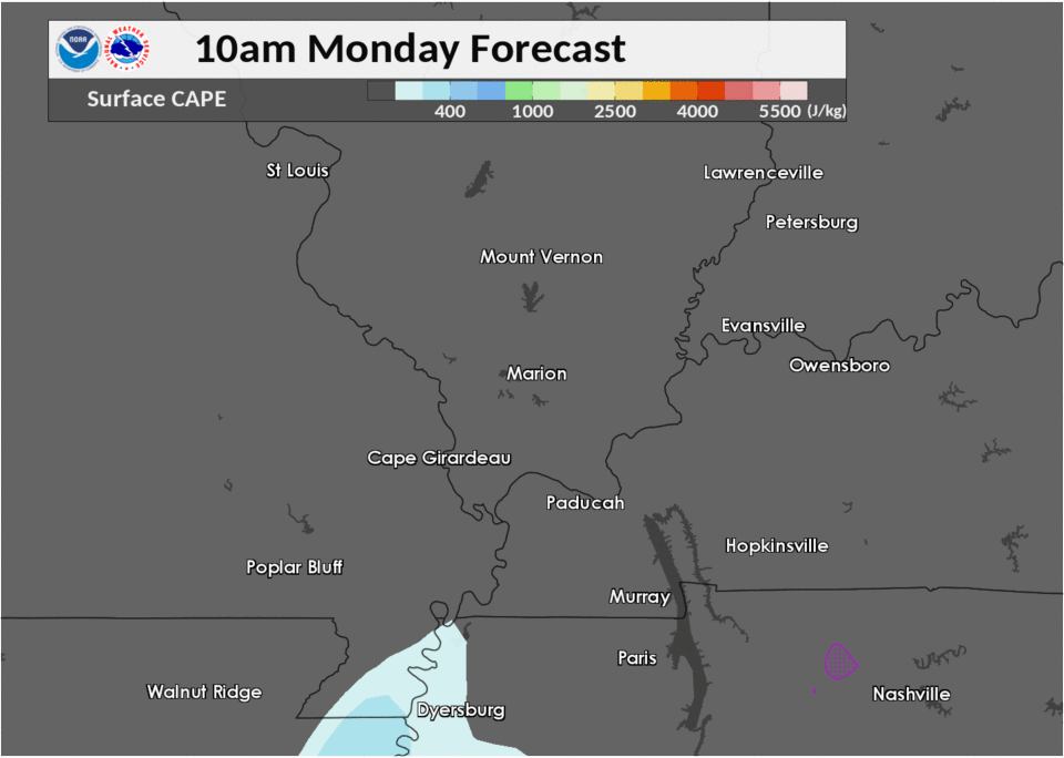
Near-storm environment summary.
 |
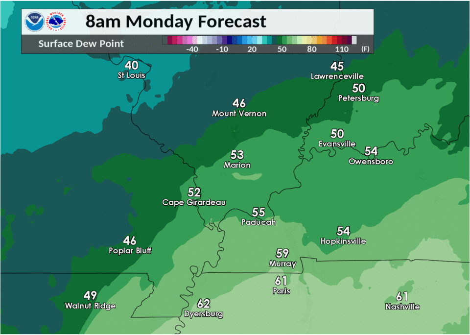 |
| Figure 4: CAPE forecast (RAP model) | Figure 6: Sfc dew points (observed) |
Additional environmental data.
 |
 |
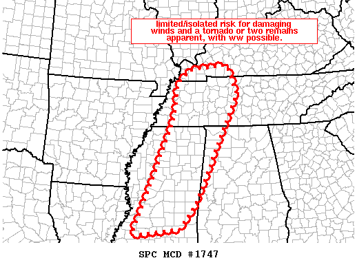 |
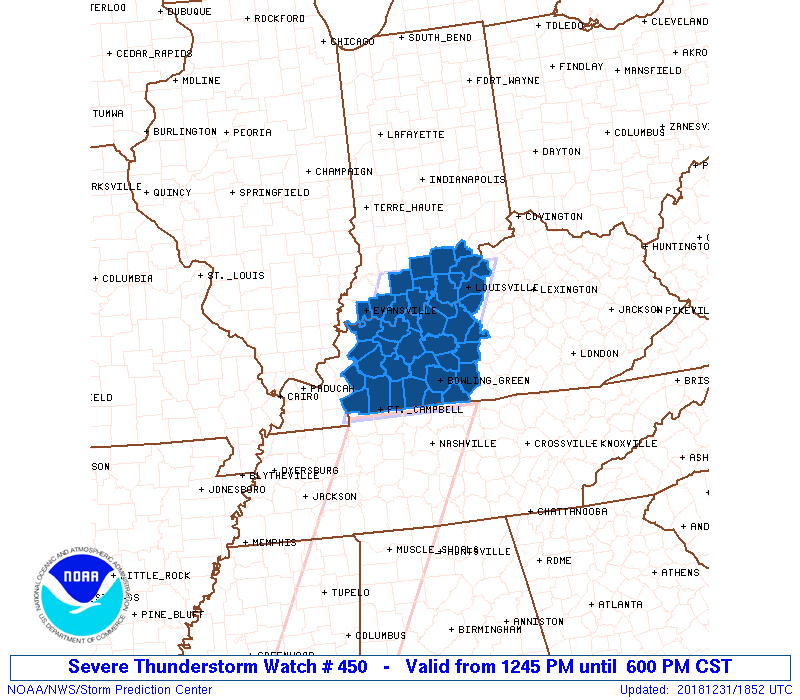
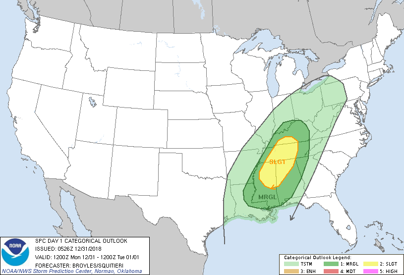
| Figure 7: Svr Tstm Watch 450 | Figure 8: Day 1 Svr Outlook | Figure 9: Mesoscale Discussion 1747 |
 |
Media use of NWS Web News Stories is encouraged! Please acknowledge the NWS as the source of any news information accessed from this site. |
|

