Overview
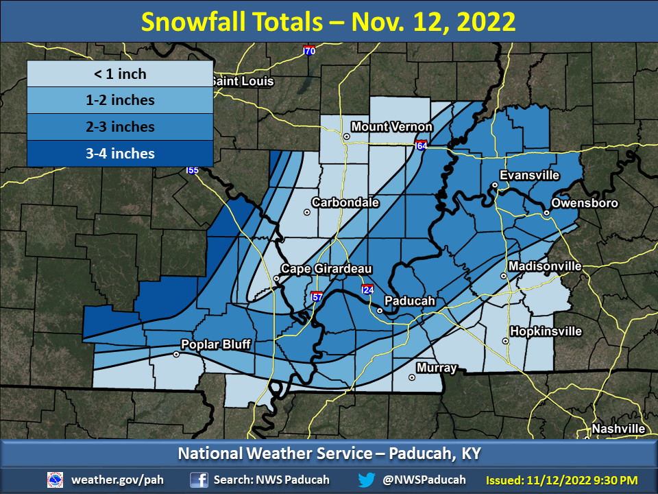
A burst of snow fell across the region during the early morning hours of November 12. Accumulations ranged from just a dusting in a few spots to three inches in other places. Average amounts ranged from 1 to 2 inches, including a swath from Evansville to Paducah. Most of the snow fell in just 1 to 3 hours between 2 AM and 8 AM. Visibility was below one mile in the heaviest snow bands, and even one-quarter mile at Evansville. Because temperatures had been in the 60's, 70's, and even lower 80's in the days preceding the snow, pavement temperatures were such that the snow melted on roads. However, snowfall rates were high enough to briefly cover bridges and overpasses, resulting in a few accidents. This unseasonably early snowfall was the third earliest snow event of an inch or more at Paducah. The earliest was on the day before Halloween of 1993 (2 inches), and the second earliest was on November 11, 2019 (1.2 inches).Snow/Ice
PRELIMINARY LOCAL STORM REPORT...SUMMARY
NATIONAL WEATHER SERVICE PADUCAH KY
304 PM CST SAT NOV 12 2022

..TIME...   ...EVENT...      ...CITY LOCATION...     ...LAT.LON...
..DATE...   ....MAG....      ..COUNTY LOCATION..ST.. ...SOURCE....
            ..REMARKS..

0421 AM     SNOW             3 W PATTERSON           37.20N 90.61W
11/12/2022  M3.0 INCH        WAYNE              MO   EMERGENCY MNGR

            MEASURED ON AN ELEVATED SURFACE.

0700 AM     SNOW             15 NW DONIPHAN          36.78N 91.01W
11/12/2022  M2.5 INCH        RIPLEY             MO   COCORAHS


0700 AM     SNOW             6 W FAIRDEALING         36.66N 90.72W
11/12/2022  M0.5 INCH        RIPLEY             MO   COCORAHS


0700 AM     SNOW             5 WNW ELLSINORE         36.96N 90.83W
11/12/2022  M2.5 INCH        CARTER             MO   COCORAHS


0713 AM     SNOW             2 WSW VAN BUREN         36.97N 91.05W
11/12/2022  E3.5 INCH        CARTER             MO   EMERGENCY MNGR

            MOSTLY ON ELEVATED SURFACES.

0700 AM     SNOW             2 SE CAPE GIRARDEAU     37.29N 89.52W
11/12/2022  M0.0 INCH        CAPE GIRARDEAU     MO   COCORAHS


0700 AM     SNOW             1 WSW OAK RIDGE         37.49N 89.75W
11/12/2022  M0.5 INCH        CAPE GIRARDEAU     MO   COCORAHS


0700 AM     SNOW             4 WNW POPLAR BLUFF      36.79N 90.47W
11/12/2022  M0.5 INCH        BUTLER             MO   COCORAHS


0700 AM     SNOW             5 ENE STURGIS           37.57N 87.90W
11/12/2022  M3.3 INCH        UNION              KY   COCORAHS


0643 AM     SNOW             4 ESE GRAHAMVILLE       37.09N 88.71W
11/12/2022  M2.3 INCH        MCCRACKEN          KY   PUBLIC


0700 AM     SNOW             1 NNE PADUCAH           37.09N 88.63W
11/12/2022  M2.5 INCH        MCCRACKEN          KY   COCORAHS


0700 AM     SNOW             2 NNE EDDYVILLE         37.10N 88.07W
11/12/2022  M1.3 INCH        LYON               KY   COCORAHS


1000 AM     SNOW             HENDERSON               37.84N 87.58W
11/12/2022  M2.5 INCH        HENDERSON          KY   PUBLIC


0700 AM     SNOW             5 W FULTON              36.51N 88.97W
11/12/2022  M1.0 INCH        FULTON             KY   COCORAHS


1000 AM     SNOW             2 W OWENSBORO           37.76N 87.16W
11/12/2022  M2.0 INCH        DAVIESS            KY   PUBLIC


1100 AM     SNOW             E OWENSBORO             37.76N 87.12W
11/12/2022  M2.0 INCH        DAVIESS            KY   PUBLIC


0700 AM     SNOW             4 NW OAK GROVE          36.71N 87.48W
11/12/2022  M0.0 INCH        CHRISTIAN          KY   COCORAHS


0700 AM     SNOW             2 WSW MURRAY            36.60N 88.35W
11/12/2022  M0.4 INCH        CALLOWAY           KY   COCORAHS


0700 AM     SNOW             4 NW KEVIL              37.13N 88.94W
11/12/2022  M2.0 INCH        BALLARD            KY   COCORAHS


0945 AM     SNOW             NEWBURGH                37.95N 87.41W
11/12/2022  M3.1 INCH        WARRICK            IN   BROADCAST MEDIA


0708 AM     SNOW             2 ESE EVANSVILLE        37.98N 87.51W
11/12/2022  M2.5 INCH        VANDERBURGH        IN   FIRE DEPT/RESCUE


1228 PM     SNOW             EVANSVILLE              37.98N 87.54W
11/12/2022  M2.3 INCH        VANDERBURGH        IN   BROADCAST MEDIA

            MEASURED NEAR DOWNTOWN.

1228 PM     SNOW             EVANSVILLE              37.98N 87.54W
11/12/2022  M2.5 INCH        VANDERBURGH        IN   ASOS

            MEASURED AT THE EVANSVILLE AIRPORT.

0700 AM     SNOW             4 WNW ROCKPORT          37.91N 87.12W
11/12/2022  M1.5 INCH        SPENCER            IN   COCORAHS

            STILL SNOWING AT TIME OF OB.

1100 AM     SNOW             SANTA CLAUS             38.12N 86.93W
11/12/2022  M2.0 INCH        SPENCER            IN   PUBLIC


0700 AM     SNOW             9 WSW EVANSVILLE        37.93N 87.70W
11/12/2022  M3.0 INCH        POSEY              IN   COCORAHS


0700 AM     SNOW             1 ENE PETERSBURG        38.50N 87.26W
11/12/2022  M0.0 INCH        PIKE               IN   COCORAHS

            JUST STARTED SNOWING AT OB TIME.

0700 AM     SNOW             FRANCISCO               38.33N 87.45W
11/12/2022  M2.0 INCH        GIBSON             IN   COCORAHS

            STILL SNOWING AT OB TIME.

0730 AM     SNOW             FORT BRANCH             38.25N 87.57W
11/12/2022  M2.5 INCH        GIBSON             IN   PUBLIC


0700 AM     SNOW             3 E CROSSVILLE          38.16N 88.01W
11/12/2022  M3.5 INCH        WHITE              IL   COCORAHS


0700 AM     SNOW             4 NW MOUNT CARMEL       38.46N 87.82W
11/12/2022  M2.4 INCH        WABASH             IL   COCORAHS


0700 AM     SNOW             COBDEN                  37.53N 89.25W
11/12/2022  M0.4 INCH        UNION              IL   COCORAHS


0716 AM     SNOW             1 ENE WARE              37.45N 89.38W
11/12/2022  M0.3 INCH        UNION              IL   TRAINED SPOTTER


0714 AM     SNOW             HARRISBURG              37.74N 88.55W
11/12/2022  M2.5 INCH        SALINE             IL   TRAINED SPOTTER


0710 AM     SNOW             2 N SAINT JOHNS         38.06N 89.24W
11/12/2022  M3.0 INCH        PERRY              IL   PUBLIC


0711 AM     SNOW             2 NW METROPOLIS         37.17N 88.73W
11/12/2022  M2.3 INCH        MASSAC             IL   TRAINED SPOTTER


0700 AM     SNOW             5 SSW MOUNT VERNON      38.25N 88.95W
11/12/2022  M0.5 INCH        JEFFERSON          IL   COCORAHS


0700 AM     SNOW             1 W CARBONDALE          37.72N 89.24W
11/12/2022  M0.8 INCH        JACKSON            IL   COCORAHS


0815 AM     SNOW             1 W SHAWNEETOWN         37.71N 88.18W
11/12/2022  M2.6 INCH        GALLATIN           IL   EMERGENCY MNGR


0700 AM     SNOW             1 NNE BENTON            38.02N 88.91W
11/12/2022  M0.8 INCH        FRANKLIN           IL   COCORAHS
.
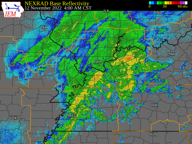
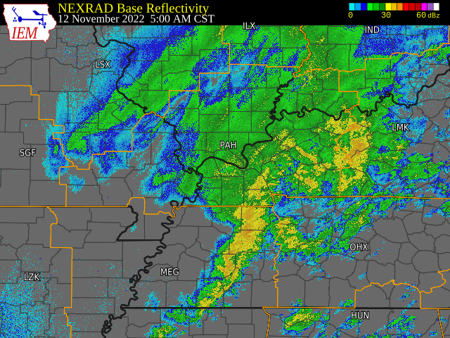
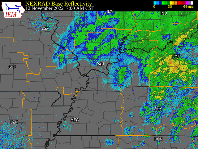
Radar
Time sequence of radar images (regional mosaics from Iowa State Univ.)
 |
 |
 |
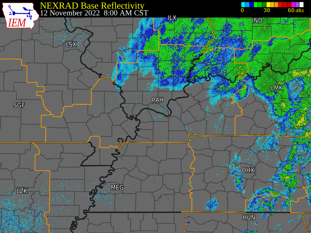 |
| Radar at 4 AM CST | Radar at 5 AM CST | Radar at 7 AM CST | Radar at 8 AM CST |
 |
Media use of NWS Web News Stories is encouraged! Please acknowledge the NWS as the source of any news information accessed from this site. |
|

