
Dangerous severe weather will continue overnight in the nation’s heartland with potentially intense tornadoes and very large hail. The threat for severe weather will shift eastward into the Ohio Valley and mid-South on Tuesday. Farther west on the back side of this large storm system, strong winds and critical fire weather will affect the southern and central High Plains through midweek. Read More >
| Forecasts for Ocean, Bay, and DE River Gauges - Numbers in Parentheses Denote Minor, Moderate, and Major Flood Levels | |
| Arthur Kill at Perth Amboy, NJ (7.1', 8.1', 9.1') | Sandy Hook, NJ (6.7', 7.7', 8.7') |
 |
 |
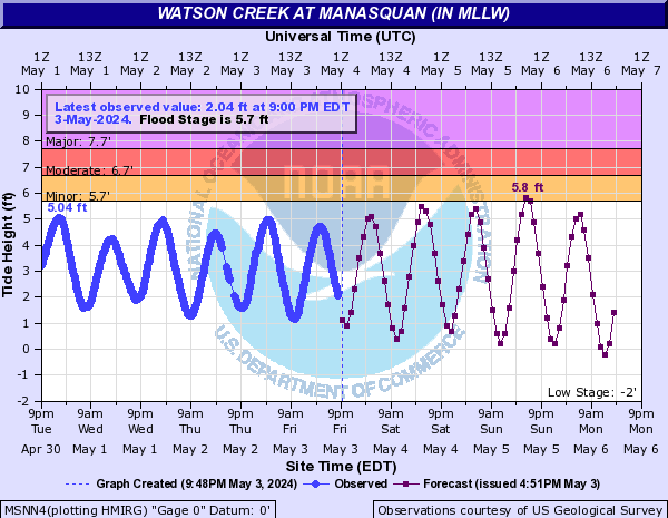
| Watson Creek at Manasquan, NJ (5.7', 6.7', 7.7') | Barnegat Bay at Barnegat Light, NJ (3.5', 4.5', 5.5') |
 |
 |
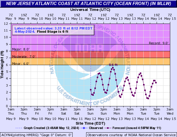
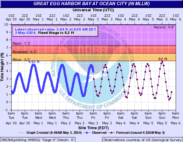
| Atlantic City, NJ Ocean Front (6.0', 7.0', 8.0') | Great Egg Harbor at Ocean City (5.3', 6.3', 7.3') |
 |
 |
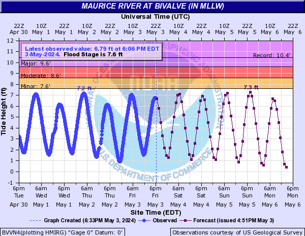
| Cape May Harbor (6.2', 7.2', 8.2') | Maurice River at Bivalve, NJ (7.2', 8.2', 9.2') |
 |
 |
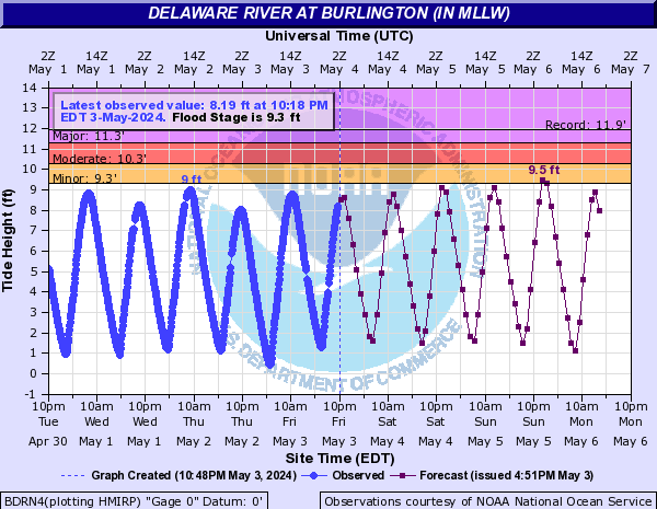
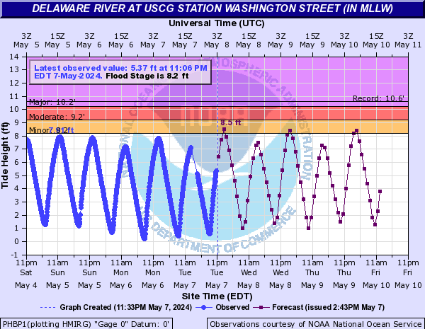
| Delaware River at Burlington, NJ (9.3', 10.3', 11.3') | Delaware River at USCG Stn Washington St (8.2', 9.2', 10.2') |
 |
 |
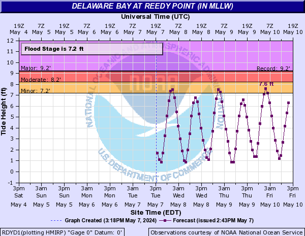
| Delaware Bay at Reedy Point, DE (7.2', 8.2', 9.2') | Murderkill River at Bowers Beach, DE (6.6', 7.6', 8.6') |
 |
 |
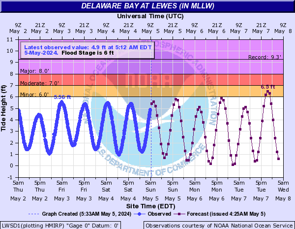
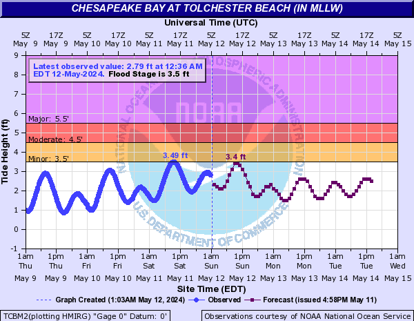
| Delaware Bay at Lewes (6.0', 7.0', 8.0') | Chesapeake Bay at Tolchester Beach, MD (3.5', 4.5', 5.5') |
 |
 |
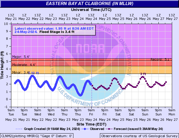
| Eastern Bay at Claiborne (3.5', 4.5', 5.5') | |
 |
|


 Coastal Flood
 Marine Forecasts
 Text Products
 Climate Information
 Skywarn
 Submit Storm Report
 Weather Event Archives
 Forecast Discussion
 Emergency Managers
 Briefing Page
 Follow us on YouTube