
Tropical Cyclone (TC) graphics available following updated bulletins issued by the Joint Typhoon Warning Center (JTWC) for cyclones within our AOR (Area of Responsibility) - extends out 300 nautical miles from Tutuila, American Samoa. Read More >
.JPG)
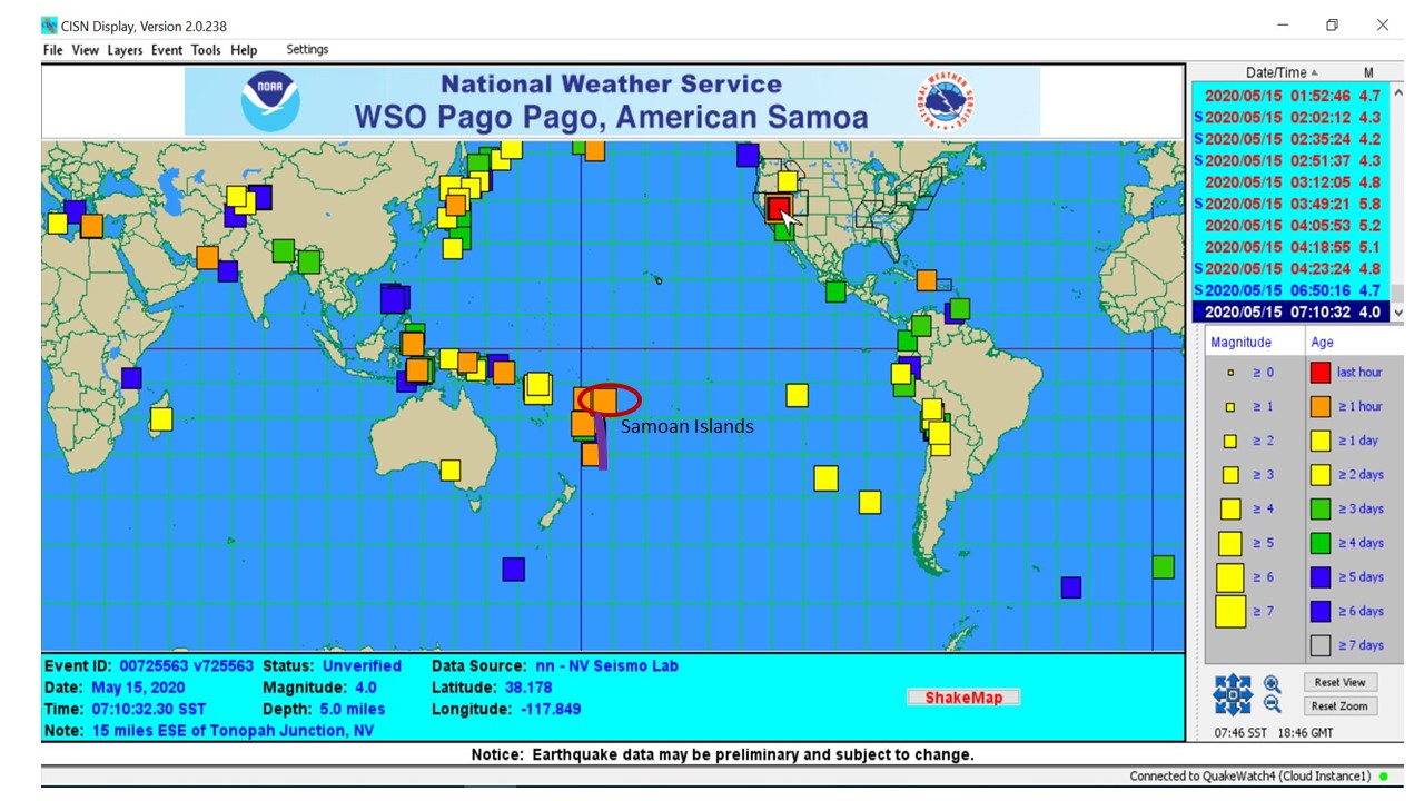
Attached here is a snippet of what a typical earthquake map would look like in a day. The size of the boxes and different colors tell the magnitude and time/date an earthquake occurred.
Quick Tips on Earthquakes for American Samoa...
1. Earthquakes happen every day and at different magnitudes/strengths and cannot be forecasted.
2. There are local/nearby (within 300 nautical miles) and distant (300+ nautical miles) earthquakes.
3. American Samoa's nearby earthquake threshold for a Tsunami Warning is 7.1 or greater, different from Samoa's threshold 7.5 or higher.
4. Our main threat is the Tongan Trench (purple curve on map), underwater.
5. It is widely encouraged that if you feel a strong earthquake for 20 seconds or more and/or you are not able to stand or see things falling off shelves, DO NOT WAIT FOR A TSUNAMI WARNING, but EVACUATE TO HIGHER GROUNDS IMMEDIATELY!
6. To keep our roads and communication lines open for first response efforts, please remain wherever you are if you are in a safe zone.
7. Have a family plan ready for a designated meeting area for you and your family if you are separated during an event.
Please contact the American Samoa Department of Homeland Security at 699-3800 for preparedness information and on safe zones. Contact National Weather Service Office at 699-9130 on any weather related and earthquake/tsunami information.


 mPING (Ripoti mai Tala o le Tau)
 Pacific Tsunami Warning Center (PTWC)
 Previous 36hrs Airport Obs (Vaaiga o le Tau i le Malae Vaalele)
 Submit a Storm Report (Ripoti mai le Tau)
 Sunrise/Sunset Info (Oso/Goto le La)
 Tides Info (Tala o le Tai)