Severe thunderstorms capable of damaging winds will be possible from the Ozark Plateau east into portions of the Southeast today. Rounds of heavy thunderstorms ahead of a slow moving front will continue locally heavy rainfall and scattered flash flooding potential from the Ozarks to the Ohio and Tennessee Valleys today. Read More >
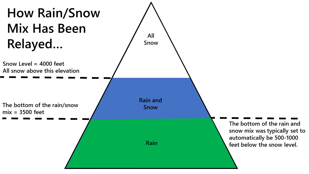
Up until December 2023, NWS Portland's official forecast has displayed a single high temperature and a single snow level forecast for a location. This has been the case even on a Day 7 forecast when uncertainty in the forecast may be high based on weather models showing a variety of scenarios. Picking a single value is not ideal.
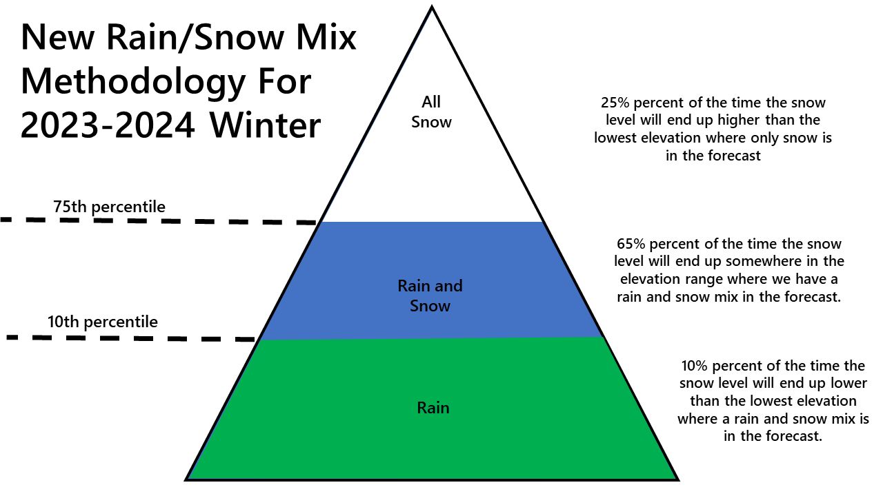
During the 2023-24 winter season, the Portland NWS office, in conjunction with surrounding Pacific Northwest offices, will be testing out a new methodology in an attempt to better communicate uncertainty in the precipitation type forecast. We will still provide a single snow level forecast, but instead of a rain/snow mix always being in the 500 to 1000 feet layer below the snow level, it will change depending on the amount of variability shown in the weather models. This will be an attempt to better communicate the uncertainty in the precipitation type forecast.
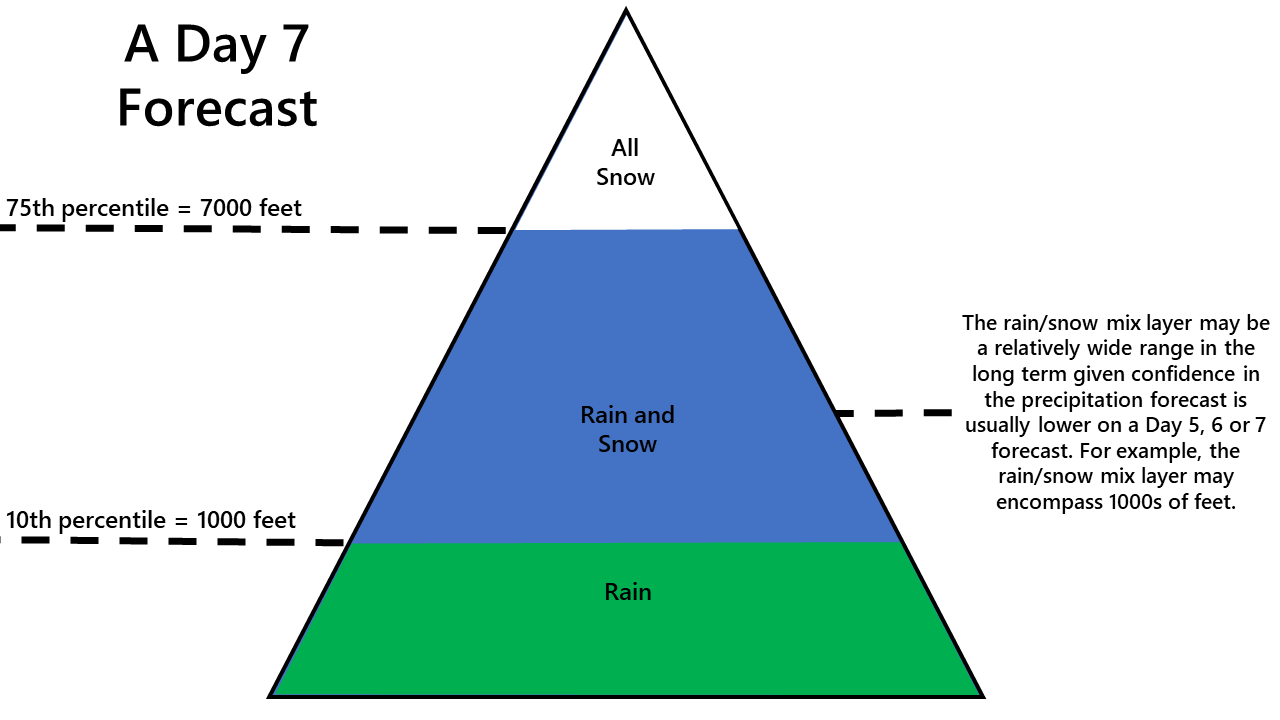
For example, we may have a scenario where 25% of the weather models suggest snow levels will be 7000 feet or higher. We may have another 10% of the weather models that suggest the snow level will end up near 1000 feet and the remaining 65% of the models suggest a snow level around 5000 feet. Traditionally, we would pick a single snow level. In this instance, it would most likely be near 5000 feet. In past winters, this would produce snow above 5000 feet, a rain/snow mix between 5000 feet and 4500 feet and rain below 4500 feet in our forecast.
This new methodology would still inform you the snow level will be around 5000 feet, but now the forecast will show all snow above 7000 feet, a rain/snow mix between 1000 and 7000 feet and all rain below 1000 feet while still communicating our snow level is most likely to end up at 5000 feet.
Snow accumulations will still be forecasted at higher elevations like 5000 feet or 6000 feet in the example above where the temperature forecast is more likely to be colder, but you may see no snow accumulations in the forecast for the lowest elevations closer to 1000 feet where the most likely temperature forecast would keep precipitation rain or prevent sticking snow. In this scenario, you may also see a temperature forecast in the 40s with a rain/snow mix in the forecast for those sites near the bottom of the rain/snow mix layer. You might scratch your head, and wonder why is the NWS forecasting temperatures in the 40s with a rain/snow mix? To put it simply, we have to pick the most likely temperature forecast, which in this case keeps temperatures in the 40s at your elevation. However, we are trying to communicate that there is at least a 10% chance that a colder scenario will pan out, temperatures will end up in the 30s and either a rain/snow mix will occur or all snow will occur. A large rain/snow mix range is much more likely to happen on a Day 5, 6 or 7 forecast than on a Day 1 forecast. Nonetheless, it's certainly possible it could happen on a Day 1 forecast when we are entering a quick warm up for example. There are high level plans to transform the NWS website to better communicate uncertainty surrounding the weather. In the meantime, this is an effort to at least communicate some of the uncertainty surrounding the type of precipitation that will fall at any given location.
Please email colby.neuman@noaa.gov if you have any questions.