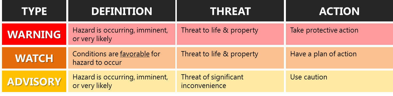
• Weather Impact Email Briefing Threshold: A 10+% probability of a hazard at Impact level 3 in the next 7 days, no matter the Risk color.
• Live Weather Briefing Threshold: A 40+% probability of a hazard at Impact level 4 in the next 7 days, no matter the Risk color.
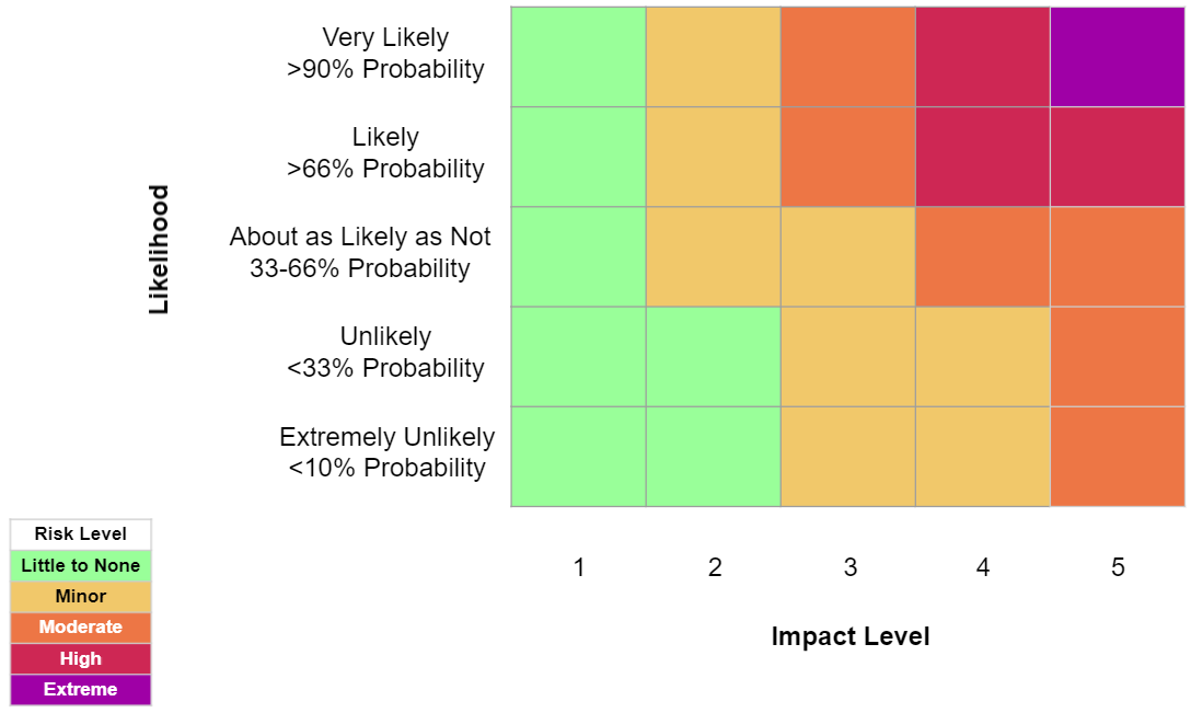
The Weather Risk Outlook is determined by a combination of the Likelihood of a weather hazard occurring and the Impact of the weather hazard using the Weather Risk Matrix shown below. The Impacts NWS Portland bases Impact Levels and briefing initiation on are also shown below.
The Weather Risk Matrix
Impact Levels
| IMPACT LEVEL | Wind | Snow | Ice | Cold | Urban Flooding and Debris Flows | River Flooding | Heat | Thunderstorms | Marine and Coastal Hazards | Fire Weather (‘Dry & Wind’ or ‘Dry & Thunderstorms’ in matrix) |
|---|---|---|---|---|---|---|---|---|---|---|
| 1 No Impactful Weather. |
• No threat of wind damage | • No snow | • No ice | • No threat of cold: Apparent temperatures 35F or warmer | • No threat of urban flooding or debris flows | • No threat of river flooding | • Little to no HeatRisk (0; Green) Do NOT use impact/likelihood table. Use NWS HeatRisk |
• No threat of thunderstorms | Marine: • Small Craft Advisory |
• Fuels are not ready to burn and/or conditions will not meet any components of a Red Flag Warning |
| 2 Potential threat to lives & property if no or incorrect actions are taken. Localized impacts on commerce are possible. |
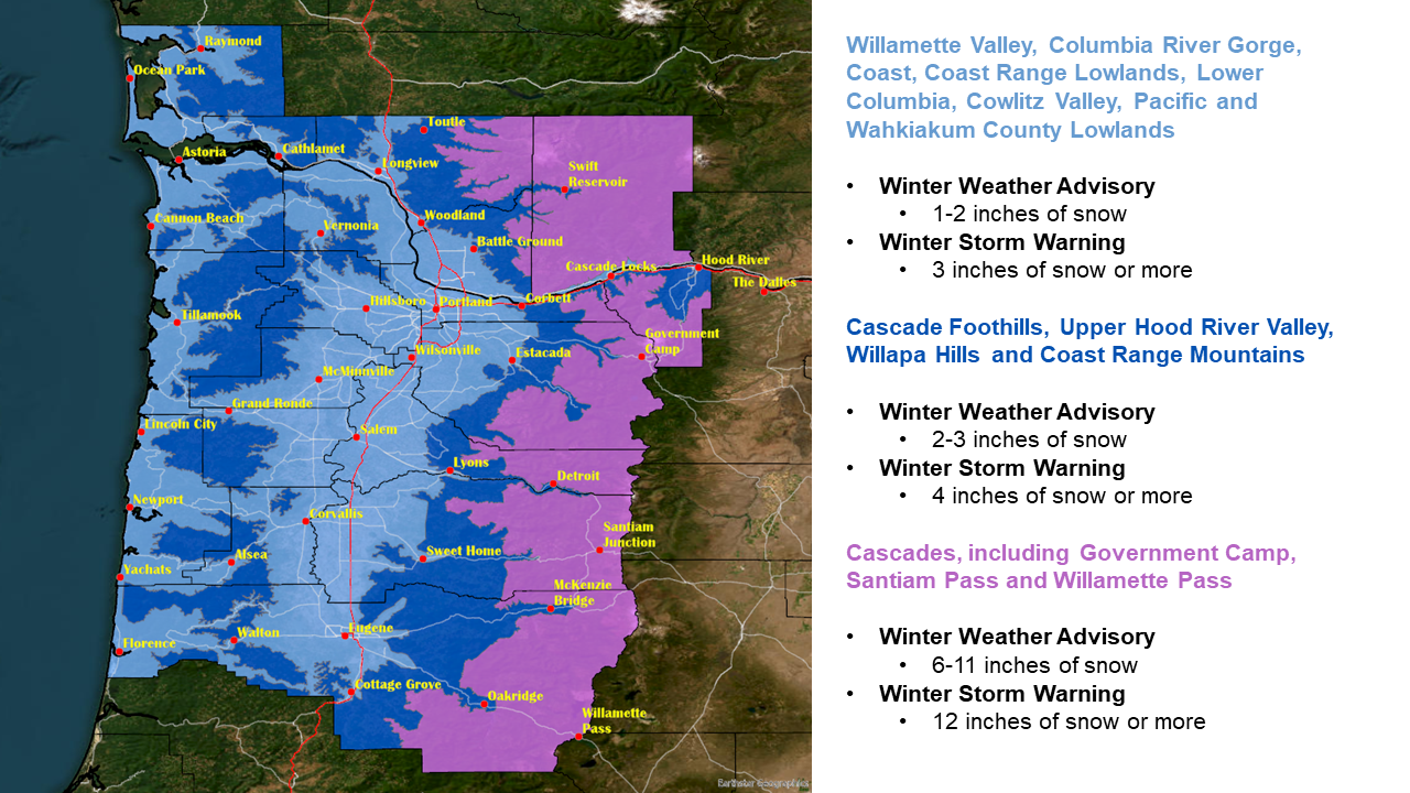
• Wind gusts 35-45 mph inland, 40-50 mph for inland coastal communities, 50-60 mph for beaches and headlands | • Snow below 2500 ft with little to no accumulation on roads • Advisory level snow above 2500 ft |
• Freezing rain that is occurring when road temps are above freezing (e.g. little to no travel impacts) • Patchy road ice not associated with freezing rain |
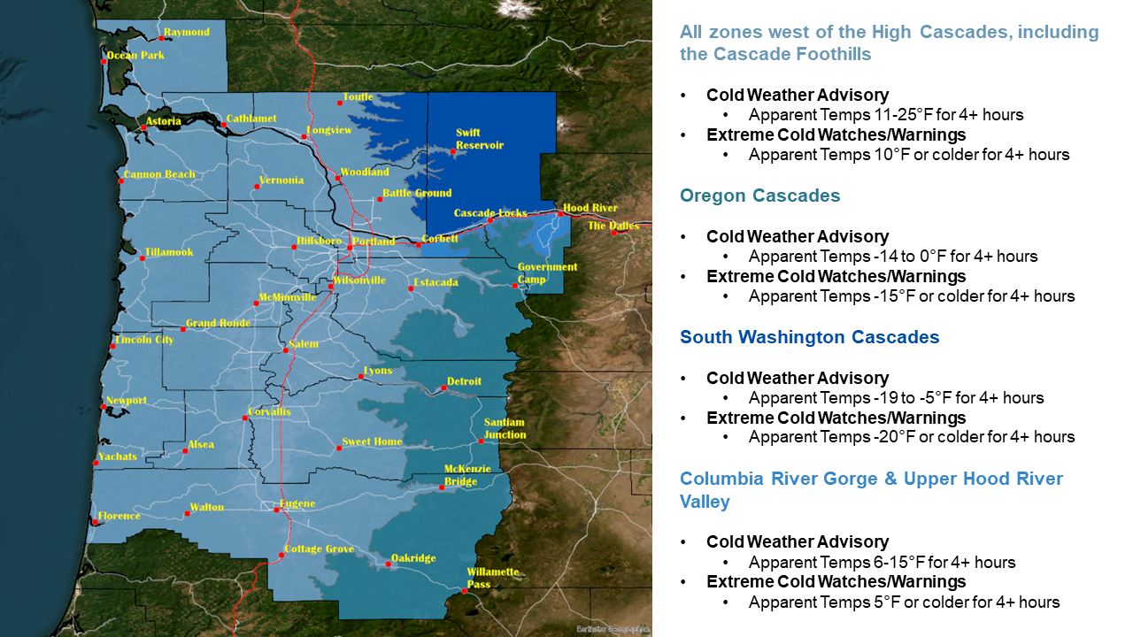
• Apparent temperatures 26-34F for elevations below 2500 ft except for 16-34F for the Columbia River Gorge & Upper Hood River Valley (focus on population centers) • Apparent temperatures between -5F and 0F for the Cascades above 2500ft NOTE: If during growing season (Apr 1-Oct 31), add freeze/agricultural impacts to your email briefing details |
• Hourly rain rates < 0.25"/hr (Winter) or < 0.5"/hr (Summer), producing minor and isolated urban flooding in low-lying flood prone areas • 2" in 24 hours for elevations in urban areas |
• Isolated minor river flooding | • Minor HeatRisk (1; Yellow); focus on levels in population centers & valleys Do NOT use impact/likelihood table. Use NWS HeatRisk *Email briefing: Include in Matrix but not in Details section |
• SPC General Thunder risk (set your thunderstorm risk level to MINOR in your email briefing) | Marine: • High-end Small Craft Advisory (gusts around 30-33 kt) • Gales (if in Fall/Winter) • Low end Hazardous Seas under 18 ft Coastal Areas: • Moderate or high risk for sneaker waves |
• Fuels are ready. Red Flag Warning wind criteria met but Relative Humidity > 25%, OR Relative Humidity < 25% and winds not meeting Red Flag Warning criteria, OR 15% chance thunderstorms with Relative Humidity < 30% |
| 3 Potential threat to lives & property if no or incorrect actions are taken. Impacts on commerce are possible. |
• Wind gusts 45-55 mph inland, 50-60 mph inland coastal communities, 60-70 mph for beaches and headlands | • Low-end warning level mountain snow above 2500 ft (12-24 inches total or rates of 1-2 inches per hour for 2 or less hours) • Advisory level snow amounts below 2500 ft, including urban areas, overnight or on weekends |
• Freezing rain occurring when road temps are below freezing and road impacts are expected: Widespread ice accumulation of 0.01-0.24" • Widespread road ice not associated with freezing rain |
• Cold Weather Advisory criteria is met NOTE: If during growing season (Apr 1-Oct 31), add hard freeze/agricultural impacts to your email briefing details |
• 0.25"/hr for 1-2 hours (Winter) or 0.5"/hr for 1-2 hours (Summer) • 0.5"/hr for 1 hour (Winter) or 1.0"/hr for 1 hour (Summer) • 3" in 24 hours for elevations in urban areas |
• Widespread minor to moderate river flooding | • Moderate HeatRisk (2; Orange) focus on levels in population centers & valleys Do NOT use impact/likelihood table. Use NWS HeatRisk |
• SPC Marginal risk (set your thunderstorm risk level to MODERATE in your email briefing) | Marine: • Gales (if in Summer) • High end Hazardous Seas of 18-19 ft • Isolated waterspouts (1 or 2 expected) Coastal Areas: • High Surf Advisory • Coastal Flood Advisory for tidal overflow |
• Red Flag Warning in effect or Red Flag conditions expected for any category |
| 4 Actions likely needed to save lives and/or property. Significant impacts to commerce possible. |
• Wind gusts of 55-65 mph inland, 60-70 mph inland coastal communities, 70-80 mph beaches and headlands | • High-end warning level mountain snow above 2500 ft (24+ inches total or rates of 2+ inches per hour for 3 hours or more) • Advisory level snow amounts below 2500 ft, including urban areas, during the middle of a week day (impacts to commutes) • Warning level snow below 2500 ft, including urban areas, overnight or on weekends • Near blizzard conditions, but visibilities are above 1/4 mile so no Blizzard Warning is expected |
• Ice storms with widespread ice accumulation between 0.25-0.5" or 0.1-0.25" of ice accumulation in populated areas along the I-5 corridor (Kelso to Eugene) | • Extreme Cold Warning criteria is met for 1 or 2 days NOTE: If during growing season (Apr 1-Oct 31), add hard freeze/agricultural impacts to your email briefing details |
• 0.25"/hr for 3-4 hours (Winter) or 0.5"/hr for 3-4 hours (Summer) • 0.5"/hr for 2 hours (Winter) or 1.0"/hr for 2 hours (Summer) • Debris flow criteria met, Flash Flood Watches/Warnings may be needed over burn areas • 4" in 24 hours for urban areas |
• Widespread moderate and major river flooding | • Major HeatRisk (3; Red); focus on levels in population centers & valleys Do NOT use impact/likelihood table. Use NWS HeatRisk |
• SPC Slight risk (set your thunderstorm risk level to MAJOR in your email briefing) | Marine: • Storm Force winds • Hazardous Seas at or over 20 ft • Freezing Spray Advisory • Several waterspouts expected (3 or more) Coastal Areas: • High Surf Warning • Low-end Coastal Flood Warning (< 3 ft) |
• Red Flag Warning in effect or Red Flag Warning conditions expected for any category with an active fire ongoing, OR Relative Humidity < 25% with gusts up to 38 mph, or Relative Humidity < 25% and 50% chance thunderstorms or higher |
| 5 Actions required to save lives and/or property. Significant and extended impacts to commerce. |
• Wind gusts over 65 mph inland, over 70 mph inland coastal communities, over 80 mph beaches and headlands | • Blizzard conditions with Blizzard Warnings expected • High-end snowstorms for elevations below 1000ft with hourly snow rates over 1"/hr during the morning and/or evening commute and snow totals around 6" or more • Historic mountain snow amounts |
• High end ice storms with widespread tree damage/power outages expected due to ice accumulations of 0.5" or higher | • Extreme Cold Warning criteria is met for 3 or more days (all 3+ days will be labeled impact 5) • A Cold Weather Advisory or Extreme Cold Warning that would coincide with the potential for power outages, which could cause infrastructure & public health impacts to buildings that would typically have adequate heating sources (ex. bursting pipes, freezing toilets, etc) NOTE: If during growing season (Apr 1-Oct 31), add hard freeze/agricultural impacts to your email briefing details |
• 0.5"/hr or more for over 3 hours or more (Winter) or 1.0"/hr for 3 hours or more (Summer) • 5" or more in 24 hours for urban areas |
• Widespread major or record flooding with impacts to major population areas • Imminent dam failure |
• Extreme HeatRisk (4; Magenta); focus on levels in population centers & valleys Do NOT use impact/likelihood table. Use NWS HeatRisk |
• SPC Enhanced, Moderate, or High risk (set your thunderstorm risk level to EXTREME in your email briefing) | Marine: • Hurricane force winds • Heavy freezing spray Coastal Areas: • Significant coastal flooding >= 3 ft (high-end Coastal Flood Warning) |
• Particularly Dangerous Situation Red Flag Warning in effect or Particularly Dangerous Situation conditions expected |
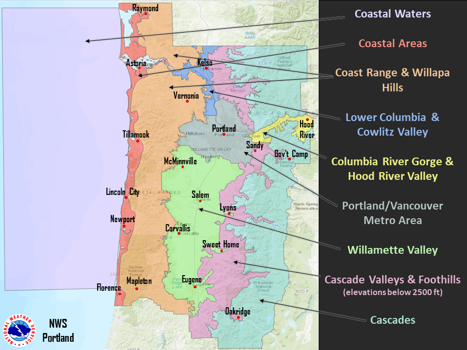
Weather Matrix Locations