March 1-2, 2023: Late Season Winter Storm Brings Low-Elevation Snowfall
|
|
Fig. 1. Water Vapor Satellite Imagery depicting the strong low pressure system moving from the west coast through Arizona on March 1-2, 2023
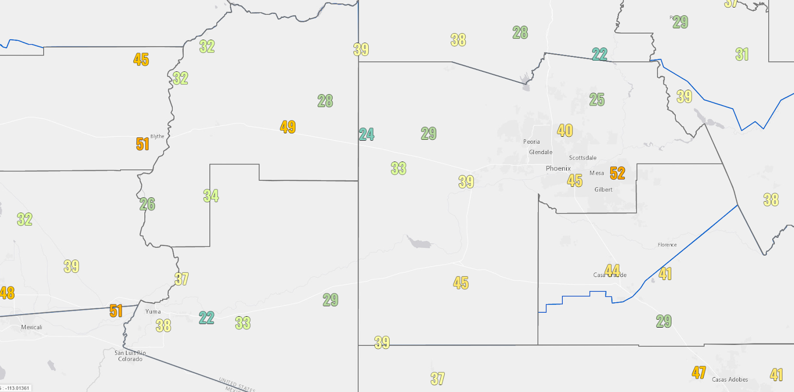
On March 1-2, 2023, a strong late-season winter storm moved from the west coast through Arizona bringing widespread gusty winds and precipitation (Fig. 1). The strongest winds were observed ahead and along an associated cold front, with widespread gusts 30-40+ mph (Fig. 2). A widespread band of moderate to locally heavy rainfall along the cold front was also observed, moving from west to east through south-central Arizona during the late afternoon and evening hours on March 1st (Fig. 3). Rainfall amounts of 0.50-1.00” were observed across most of the Phoenix metro area, with locally higher precipitation amounts of over 1.00” confined across the higher terrain areas to the north and east of the metro (Fig. 4).
|
|
Fig. 2. Max wind gusts observed in MPH on March 1, 2023
|
|
Fig. 3. Radar reflectivity loop from 5:30 PM MST March 1, 2023 through 3 AM MST March 2, 2023 from the KIWA (Phoenix, AZ) radar
|
|
Fig. 4. Observed precipitation totals on March 1-2, 2023
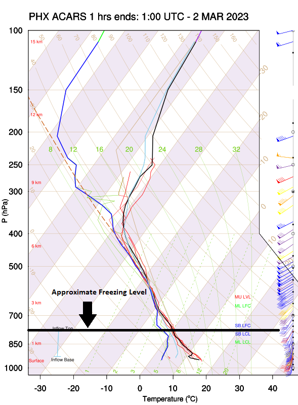
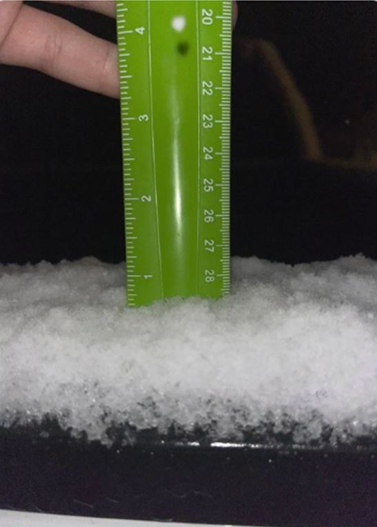
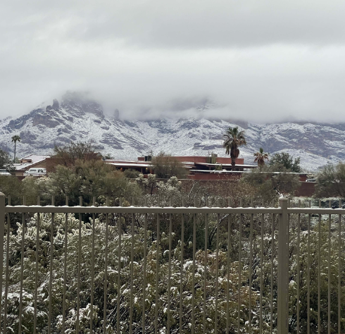
However, the more interesting aspect of the storm came after the cold front passage during the late evening into the overnight hours of March 1st into the 2nd as colder air building in caused snow levels to significantly drop below 2000-2500 feet. The progression of the colder air mass can be seen by the aircraft data obtained in Phoenix before and after the frontal passage during the evening hours of March 1st with the height of the freezing level getting progressively lower with time (Fig. 5-8). With enough moisture still present, the airmass was just cold enough for the rain change to snow in areas just on the fringes of the Phoenix metro. Measurable snow was reported in places such as North Scottsdale, Gold Canyon, and Queen Valley, located just to the north and east of the metro at elevations between 1800-3000 feet (Fig. 10-13). Even though snowfall did not amount to much, it was noticeable given that it was observed in areas that rarely see it.
|
|
|
Fig. 5-8. Observed weather data obtained from aircraft at Phoenix, AZ (clockwise from top-left) at 6:00 PM MST (March 1); 11 PM MST (March 1); and 3 AM MST (March 2)
|
|
Fig. 9. Total Snow depth from 06z February 28th to 06z March 4th, 2023. Note the measurable amounts on the foothills just to the north and east of the Phoenix metro during March 1st-2nd with the winter storm.
|
|
|
|
|
|
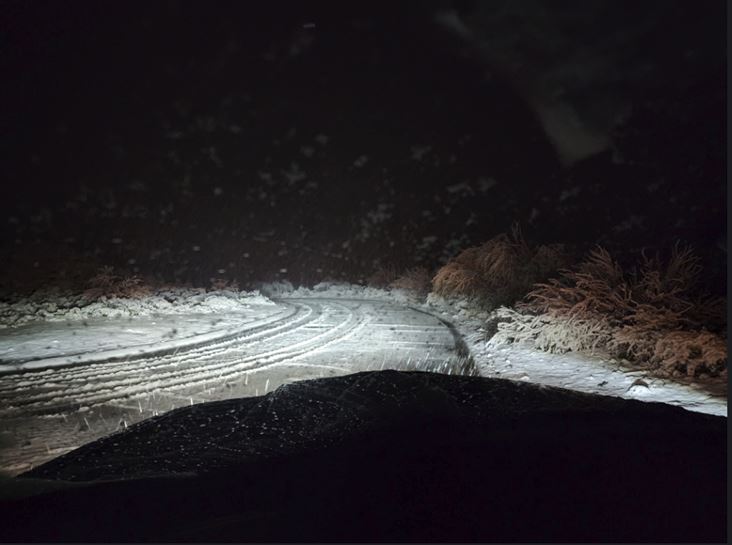
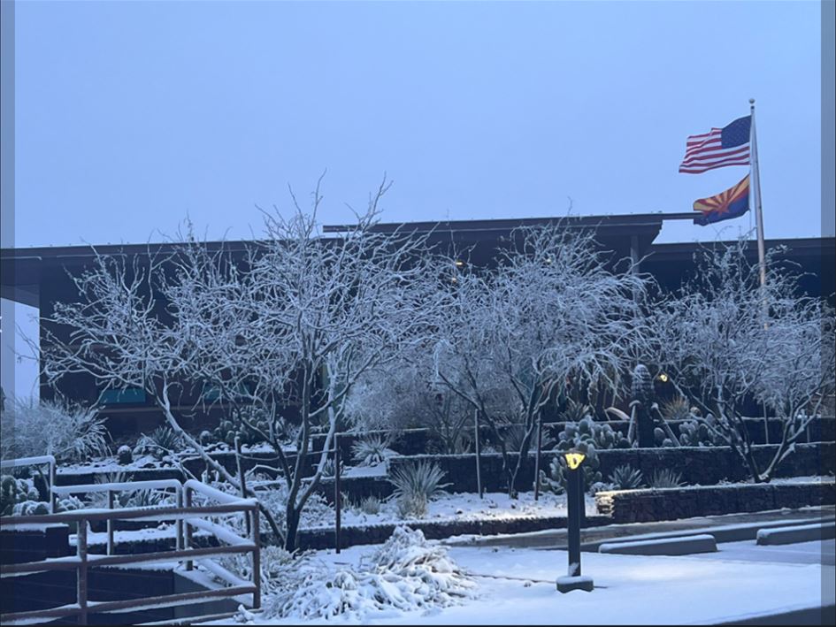
Fig. 10-13. Images from the snowfall accumulations in the fringes of the Phoenix metro. Image location and sources (clockwise from top-left): Snow across Saguaro forest in desert mountain in North Scottsdale, AZ at approximately 3000 ft. elevation (credit: Mason Meiners); Snow at Fire Station 616 in North Scottsdale, AZ at approximately 3000 ft. elevation (credit: Scottsdale Fire Department); Snow in Gold Canyon at approximately 1800 ft. elevation (credit:Craig Codiga); Snow at Queen Valley, AZ at approximately 1900 ft. elevation (credit: @Chris19670756 on twitter)
Why were snow levels, even in early March, so low across the area? The biggest factor was the very cold air mass this storm system brought. According to the North American Ensemble Forecast System (NAEFS), temperatures in the mid to lower-levels of the atmosphere (500-850 hPa layer), were anomalously cold with values near record minimum (Fig. 13). As a result, the air mass was cold enough for snow to fall at low elevations.
|
|
Fig.13. North American Ensemble Forecast System showing the mean temperature and climatological percentile at 200 hPa (about 40,000 ft. above MSL), 500 hPa (about 18,000 ft. above MSL), 700 hPa (about 10,000 ft. above MSL), 850 hPa (about 5,000 ft. above MSL) and 1000 hPa (near sea level)


 Follow us on YouTube