National Weather Service United States Department of Commerce
 
Flooding in Indiana

On this page you learn what types of flooding are typical in Illinois and how do you protect yourself, your family and your home. You will also find out more about significant Illinois floods. Finally, you'll find links to NWS offices that provide forecast and safety information for Illinois, as well as links to our partners who play a significant role in keeping you safe.

Significant Illinois Floods

+Summer 1993 Flood

+July 1996 Flash Flood, Northeast IL

Location impacted (areal coverage): Northeast Illinois
Number of fatalities: 2
Number of injuries: UnknownJuly 17-18 1996

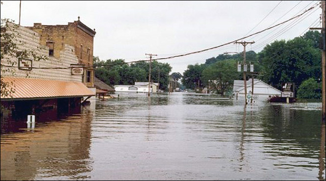
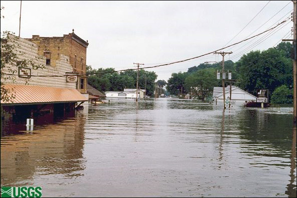
Record rainfall produced flash flooding over Northeast Illinois. A new state 24-hour rainfall record was set when Aurora, IL, received 16.94 inches of rain. Major flooding along portions of the Fox, Illinois, and DuPage Rivers occurred, causing widespread flood damage. Record flood discharges were recorded at 19 USGS streamflow gaging stations, with near record discharges at several more stations. One notable record discharge was that of the Du Page River at Shorewood, IL. This station experienced a record stage of 14.03 feet. The previous record was 11.06 feet, set in October 1954. The record discharge was 17,300 cfs measured on July 18, 1996. The flooding caused hundreds of millions of dollars of damage and resulted in 2 deaths. Numerous houses were inundated and many bridges were washed out. Three dams in the region experienced partial or complete failure. The following excerpt from a post event study by the Illinois State Water Survey details some of the impacts as a result of the record rainfall:

  • Approximately half of the homes in Aurora sustained flood damage.
  • About 200 homes in the Mayfair subdivision in Joliet were severely damaged, and the city reported 8,000 other homes with flood damage.
  • About 100 homes in Montgomery were badly damaged (at a cost of $10 million), and 200 homes were flooded in the Parkview Estate subdivision.
  • Damage totaled $40 million from severe flooding of 1,878 Shorewood homes, which affected 7,200 people.
  • About 200 trailers in a Sycamore trailer camp were inundated, resulting in the loss of 152 trailers.
  • A subdivision in Cortland was flooded by 8 feet of water and 78 homes were badly damaged.
  • Chicago reported some 23,000 flooded basements.
  • A Kirkland trailer park was flooded and 84 trailers were damaged or destroyed.
  • Several subdivisions in and near lisle were flooded, with over 400 homes damaged.
  • Between 60 and 80 homes in New Milford were flooded.

Learn More:

+June 2008 Flood

Location impacted (areal coverage): Detailed below
Number of fatalities: Unknown
Number of injuries: Unknown
Dollar damage: Unknown

June 1-15, 2008 Midwest Precipitation Summary from NCDC

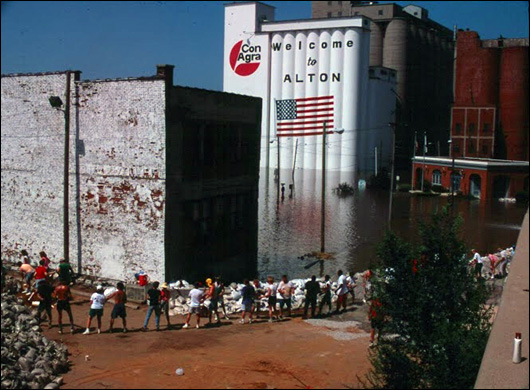
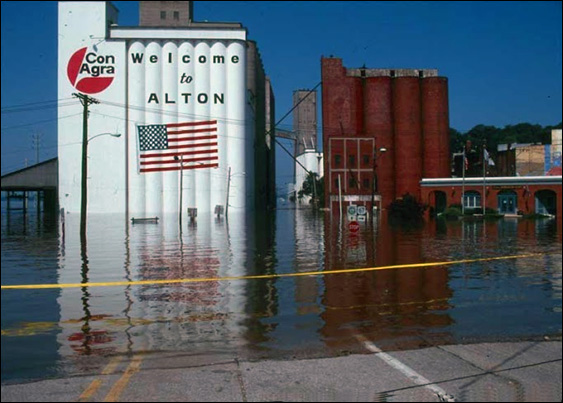
During the course of the first half of June 2008, much of the Midwest received copious amounts of rainfall as one storm system after another traversed the region. Parts of Indiana, Illinois, Iowa and Wisconsin were recipients of over a foot of rainfall, with widespread flooding reported along the Mississippi River and its tributaries. Dams and levees were breached across parts of Wisconsin, Iowa, Indiana and along the Mississippi River. Historical record high streamflows occurred in some of the major regional rivers including the Des Moines, Cedar and Wisconsin Rivers. Reported river crests exceeded 500-year levels in some locations. Major levees in Des Moines and Cedar Rapids were breached, forcing evacuations and causing extensive damage. Navigation along the Mississippi River was affected by the closure of several of the locks and dams. By the end of June, many of the communities along the Mississippi River from Rock Island, IL to Cape Girardeau, MO were still experiencing major flooding.

Prior to this flood event, much of the Upper Mississippi and Ohio River Basins had experienced wet conditions during the 2007-2008 winter and into the spring. Notably, over the past 6 months, eastern Iowa (climate divisions 3 and 6) and southern Wisconsin (climate divisions 7, 8 and 9) have been characterized by Standardized Precipitation Index (SPI) values greater than +2, extremely wet conditions which normally occur less than 2.5% of the time. Precipitation received across the Upper Mississippi Basin from December 2007 through May 2008 was the 2nd wettest in the 1895 to present record, illustrating how saturated the region was prior to this event. The vast majority of the rainfall received in June across the region was subsequently channeled directly into the lakes, rivers and streams, which is an important factor in the severity of the flooding. The 13 June USGS river gauge monitor indicated historic high streamflows across much of Iowa, southern Wisconsin and northern Illinois. Many of the gauges in this region remained much above normal throughout the remainder of June.

In June, Wisconsin's climate divisions 6, 7, 8 and 9, Indiana's division 4 and Michigan's division 4 were all the wettest on record. Precipitation received across the state of Iowa led to a ranking of 2nd wettest during June 2008. For the most recent 3-month period (April through June), Iowa ranked wettest and the East North Central region was 2nd wettest since records began in 1895. The year-to-date (January through June) rankings illustrate the persistent wetness across much of the Midwest. Iowa, Missouri and Ohio were all record wettest. Illinois, Indiana and the East North Central region were 2nd wettest.

The large-scale weather pattern during the first 2 weeks of June primarily consisted of a high pressure system over the southern Plains and Ohio Valley and abnormally low pressure situated over the northern Plains. The boundary between these two pressure systems was the focal point for the development of the heavy rainfall and severe storms. The 300mb chart for the evening of June 5, 2008, shows the jet stream position across the High Plains and is an indicator for locations which favor severe weather. The persistence of this pattern over the first half of June exacerbated the magnitude of the rainfall accumulations and subsequent flooding.

Northern Illinois
Torrential rainfall over portions of the upper Rock, Pecatonica, Fox, and Des Plaines rivers in southern Wisconsin resulted in widespread record flooding especially in the upper Rock and Fox watersheds. As that water began to move downstream into northern Illinois, rivers began to rise.

Fox River 
Areas along the upper Fox River experienced flooding once again as high flows from Wisconsin moved downstream. This was the third significant flood episode in the last year for many residents along the Chain O’Lakes area and upper Fox River. It was estimated that around 408 structures were damaged by flooding along the Chain O’Lakes and upper Fox River. In Lake County IL, 103 structures received minor to significant damage, 305 structures had water up to crawlspaces, water affecting the well or septic systems, water affecting driveways or access to structures, or water affecting accessory structures. Most of the flooding occurred along the Fox River from the Wisconsin/Illinois state line down to areas in Kane County. 

Rock River 
Significant flooding occurred along the upper Rock River especially in the Machesney Park area and locations north of Rockford. It was reported that 600 homes were affected by flooding in the Machesney Park area. The Rock River at the Rockton gage location crested at the second highest peak on record. 

Southeastern Illinois 
Due to very heavy rain that fell across east-central and southeast Illinois from June 6-8, both the Embarras and Wabash rivers overflowed their banks, breaching several levees. As a result, widespread flooding occurred across eastern Lawrence County, with over 75 square miles affected. 

Embarras River 
Four levee failures led to widespread flooding in eastern Lawrence County. At approximately 0133 CST on June 10, Lawrence County emergency managers reported a 100 yard wide levee failure along the Embarras River just northwest of Lawrenceville. At approximately 0136 CST on 6/10, Lawrence County emergency managers reported a 200 yard wide levee failure along Otter Pond Creek two miles west of the Lawrenceville airport. At approximately 0655 CST on 6/10, Lawrence County emergency managers reported a 400 yard wide levee failure along the Embarras River near Beaver Creek just south of Lawrenceville. At approximately 0703 CST on 6/10, Lawrence County emergency managers reported a levee failure along the Wabash River one mile south of the Lincoln Memorial Bridge.

As a result of the heavy rainfall and additional flooding from the levee failures, the town of Lawrenceville had 158 homes with water in the first floor living area, while 48 others reported water in the basement. Eight businesses had in excess of 5 feet of water. Record crests we observed along the Embarras River leading up to the levee failures.

  • Record crest (28.06') on the Embarras River at Ste. Marie (STMI2) on 6/7.
  • Record crest (42.61') on the Embarras River at Lawrenceville (LAWI2) on 6/10.

Learn More:

+Spring 2011 Middle & Lower Mississippi River Valley Floods

Location impacted (areal coverage): Most of southern Illinois (south of I-64)
Number of fatalities: 0
Number of injuries: Unknown
Dollar damage: Approximately $8 million across southern IL

Southern Illinois 
Heavy rainfall in March set the stage for flooding when heavy and even record-setting rains fell in April and May. From April 22 to May 3, between 9 and 22 inches of rain fell across the region. Rainfall totals for April-May at some Illinois sites include: 22.89” at Crab Orchard, 19.54” at Cairo, 26.06 inches at Carmi, 22.41” at Murphysboro, and 22.25 inches at Carbondale. There was approximately $8 million in damage across southern Illinois alone. There was no loss of life. 

Many communities spent the better part of 2 weeks sandbagging their homes and businesses and trying to shore up existing levees. Whole communities were evacuated with hundreds of homes eventually flooding. Dozens of roads were closed and just traveling across southern Illinois proved difficult in several locations. Some schools and government offices closed during the flood. Water treatment plants were sandbagged.

When the Birds Point-New Madrid Floodway was activated on May 2, many communities had chosen to pull back and let nature run its course. Brookport, IL, had ended its flood fight and the flood wall at Cairo was in danger of overtopping. The effects of the activation were immediate and substantial on the lowest part of the Ohio River.

Below are some crests from the event:

Big Muddy River
Plumfield: 34.68 ft, 5/4/2011, Record
Murphysboro: 40.42 ft , 5/2/2011, Record

Little Wabash
Carmi, 38.34 ft,,5/3/2011, 2nd highest crest on record

Skillet Fork River
Wayne City: 22.88 ft, 4/28/2011 5th highest crest on record

Ohio River
Brookport: 57.00 ft, 5/6/2011, 2nd highest crest on record
Grand Chain: 62.20 ft, 5/3/2013, 2nd highest crest on record
Cairo: 61.72 ft, 5/3/2013, Record
(The crests at Brookport and Grain Chain are 2nd only to the Great 1937 Flood on the Ohio River)

Learn More:

+April 2013 Record Des Plaines and Illinois River Flood

Location impacted (areal coverage): Areas along the Des Plaines and Illinois Rivers
Number of fatalities: 1
Number of injuries: Unknown
Dollar damage: Approximately $375 million from flash flooding and river flooding

A nearly stationary frontal boundary, interacting with an unseasonably warm and moist airmass, brought widespread showers and thunderstorms to parts of northern and central Illinois from the later afternoon of April 17 through the morning of April 18. Several rounds of thunderstorms produced torrential rainfall, major flash flooding and subsequent river flooding. Between 4 and 8 inches of rain fell across the most heavily impacted areas. Some of these areas experienced rainfall rates of up to 2 inches per hour. This was exacerbated by the fact that soils in these areas were already saturated. Plus water levels in area rivers were already high due to a combination of snowmelt and a wet early spring.

The heavy rain caused record flooding on portions of the DesPlaines River, North Branch of the Chicago River, the Illinois River, Vermillion River, east branch of the DuPage River, and the Fox River. Marseilles was especially hard hit when barges broke loose from a tug, damaging the dam. Many homes were inundated. One person died in LaSalle County while attempting to drive around a barricaded road.

Widespread flooding was reported across the county.
  • All lanes on Interstate 94 were impassable near Pratt Avenue.
  • Hundreds of homes were flooded, including homes along the Des Plaines River where some basements were flooded to the ceiling.
  • The exit ramp from Interstate 90 to Arlington Heights Road was blocked due to flooding.
  • Over 6 inches of water was reported on Milwaukee Avenue from Golf Road to north of Glenview Road.
  • Expressways were closed due to flooding.
  • Chicago received over 1,200 calls for flooded basements.

Grundy County:

  • Hardest hit areas were Morris, Mazon, and Minooka.
  • Numerous rescues took place, including people trapped in vehicles in rising waters.
  • Forty-four patients at Morris Hospital were evacuated when the lower floor flooded.
  • The aqueduct that carries the I&M canal over Nettle Creek collapsed.
  • South of Morris, Pine Bluff Road was impassable with approximately a foot of water.

Lake County:

  • A levee was breached in Lincolnshire, IL requiring 49 homes to be evacuated.
  • Route 41 was closed between Route 137 and Route 176.
  • Near Beach Park, water was reported over many roads, ponds were out of banks, and many homes had water up to doorsteps.
  • County emergency managers estimated that 4,500 properties were affected by the flooding.

DuPage County:

  • Du Page County received the most rainfall during this evening with several sites reporting over seven inches of rain.
  • Widespread flooding was reported over much of DuPage County.
  • Dozens of homes were underwater in Towers of Four Lakes Village requiring emergency crews to rescue people trapped inside.
  • Numerous roadways were covered with flowing water causing several cars to stall.
  • Lower levels of several apartment buildings were flooded.
  • Retention ponds were overflowing.
  • Roosevelt Road was closed between Wegner Drive and Joliet Street due to high water.
  • Portions of Route 53 were closed between 75th Street and Royce Road.
  • Numerous basements were flooded near Elmhurst, Lisle, and Naperville.
  • Some residents had to be rescued in Lisle.
  • The Glen Ellyn Public Library building's sub-basement flooded under five feet of water and also received extensive damage on the first floor.
  • In Lombard, basements as well as first floors were flooded.
  • Approximately 30 streets in Lombard were completely submerged.

LaSalle County:

  • Approximately six inches of running water was reported a mile east of Route 251 on North 2nd Road, making the road impassable.
  • County emergency managers estimated that over 500 buildings were damaged by flooding across La Salle County.
  • In Marseilles, 1500 people were evacuated due to a compromised levee which led to dozens of homes and facilities being flooded along the river front.
  • Several barges broke loose from a tugboat on the Illinois River and rammed into the levee.
  • Five of the eight locks were damaged such that they could not close completely.
  • Flooding occurred in Utica east of Route 178 resulting in evacuations on the I&M Canal.
  • Creeks were reported out of their banks in Mendota.

Woodford County:

  • Hundreds of homes and businesses in Roanoke, Eureka and Metamora were flooded and several water rescues had to be made.
  • Roads near the town of Minonk were flooded with more than one foot of flowing water.
  • Every road from the central to northeast part of the county was impassable.
  • No injuries were reported.
  • $18 million in property damage.

Schuyler County:

  • Damage to hundreds of houses in the county, which included several basement walls which collapsed.
  • Nearly every creek and stream in the county was flooded, which damaged a few bridges and culverts.
  • Nearly every road in the county was also impassable with water one to two feet deep in spots.
  • Several water rescues were made.
  • $2 million in property damage.

Fulton County:

  • Nearly 2000 damaged houses in the county.
  • Several homes had to be evacuated in the town of London Mills.
  • Every creek and stream in the county was flooded, which damaged a few levees and culverts.
  • Nearly every road in the county was impassable, and numerous water rescues were made.
  • The levee protecting the town of London Mills from the Spoon River broke in several locations during the evening of April 18th. This exacerbated the flooding which had already occurred the night before from torrential rainfall.
  • Twenty houses were inundated on the south side of London Mills.
  • Illinois Route 116 and County Road 2 were under several feet of water.
  • Evacuations had been done so there were no injuries reported.
  • $13.7 million in property damage.

Peoria County:

  • Damage to thousands of houses and businesses in the county, including the city of Peoria where two houses collapsed into the basement injuring two people.
  • Every creek and stream in the county was flooded.
  • Nearly every road in the county was impassable, including parts of Interstate 74 which had to be closed.
  • Numerous water rescues were made.
  • Mudslides were also reported along the eastern bluffs along the Illinois River.
  • $100 million in property damage.

Tazewell County:

  • Damage to thousands of houses and businesses in the county, which included the cities of East Peoria, Pekin, Washington and Morton.
  • Every creek and stream in the western and northern part of the county was flooded.
  • Nearly every road in the flooded area was impassable, including parts of Interstate 74 which had to be closed.
  • Numerous water rescues were made.
  • Mudslides were also reported on the bluffs along the Illinois River which did damage to a gas station and covered U.S. Highway 150 with several inches of mud.
  • $31.4 million in property damage.

Marshall County:

  • Damage to about 2,000 houses and businesses in the county, including several in the cities of Henry and Lacon.
  • Every creek and stream in the county was flooded.
  • Every road in the county was impassable.
  • Several water rescues were made.
  • Numerous roads and culverts were damaged by the flash flooding.
  • $10 million in property damage.

Knox County:

  • Damage to thousands of houses and businesses in the county, including several in the cities of Galesburg and Knoxville.
  • Every creek and stream in the county was flooded.
  • Nearly every road in the county was impassable, and several water rescues were made.
  • $39.5 million in property damage.

Stark County:

  • Damage to 1000 homes and businesses.
  • Every creek and stream in the county was flooded.
  • Nearly every road in the county was impassable, and several water rescues were made.
  • $5 million in property damage.
River Flooding (Over $50 million in damage):
  • Record crest (24.91") on the Illinois River at Morris (MORI2) on 4/19.
  • Record crest (473.72") on the Illinois River at Ottawa (OTWI2) on 4/19.
  • Record crest (24.91")) on the Illinois River at Morris (MORI2) on 4/19.
  • Record crest (34.44")) on the Illinois River near LaSalle (LSLI2) on 4/20.
  • Record crest (32.87") on the Illinois River at Henry (HNYI2) on 4/22.
  • Record crest (29.35")) on the Illinois River at Peoria (PIAI2) on 4/23.
  • Record crest (27.78")) on the Illinois River at Havana (HAVI2) on 4/25.
  • Record crest (29.81")) on the Illinois River at Beardstown (BEAI2) on 4/27.
  • Record crest (35.83")) on the Spoon River at Seville (SEVI2) on 4/20.
  • 2nd highest crest (26.50")) on the Spoon River at London Mills (LNMI2) on 4/19.
  • 3rd highest crest (459.57")) on the Sangamon River near Chandlerville (CDLI2) on 4/24

Learn More:

Flood Hazard Information

+Flash Flooding

Flash flooding is a rapid and extreme flow of high water into a normally dry area, or a rapid water level rise in a stream or creek above a predetermined flood level, beginning within six hours of the causative event (i.e., intense rainfall, dam failure, ice jam). More information...

+River Flooding

River flooding occurs when river levels rise and overflow their banks or the edges of their main channel and inundate areas that are normally dry. More information...

+Tropical Systems and Coastal Flooding

At any time of year, a storm from over the ocean can bring heavy precipitation to the U.S. coasts. Whether such a storm is tropical or not, prolonged periods of heavy precipitation can cause flooding in coastal areas, as well as further inland as the storm moves on shore. More information...

+Ice/Debris Jams

A back-up of water into surrounding areas can occur when a river or stream is blocked by a build-up of ice or other debris. Debris Jam: A back-up of water into surrounding areas can occur when a river or stream is blocked by a build-up of debris. More information...

+Snowmelt

Flooding due to snowmelt most often occurs in the spring when rapidly warming temperatures quickly melt the snow. The water runs off the already saturated ground into nearby streams and rivers, causing them to rapidly rise and, in some cases, overflow their banks.More ainformation...

+Dam Breaks/Levee Failure

A break or failure can occur with little to no warning. Most often they are caused by water overtopping the structure, excessive seepage through the surrounding ground, or a structural failure. More information...
Protect Life and Property                                NWS Forecast Offices and River Forecast Centers (RFC) Covering Illinois