Southeast RFC
River Forecast Center
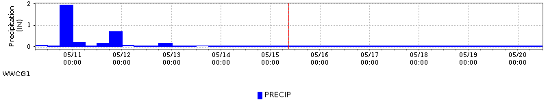
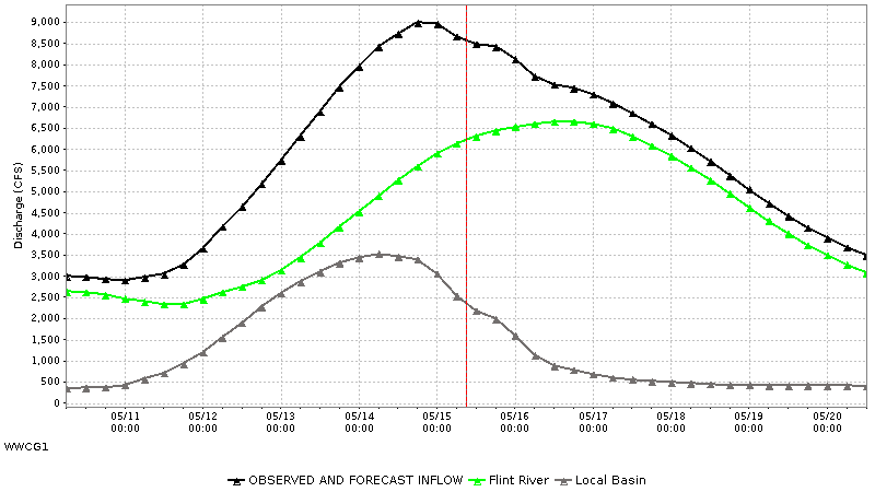
These graphs are automated model output produced every three hours. If you have any questions on the inflow guidance please call our office...770-486-0028 ext 1.
Updated: Apr 04, 2026 @ 04:00:01Z
<center>
| Crisp County Dam Gridded Precipitation Areal Mean Estimate IN | INFLOW River Discharge Simulated Instantaneous CFS | |
|---|---|---|
| 03/30/2026 06GMT | 0.00 | 2369.71 |
| 03/30/2026 12GMT | 0.00 | 2353.48 |
| 03/30/2026 18GMT | 0.00 | 2338.94 |
| 03/31/2026 00GMT | 0.00 | 2324.95 |
| 03/31/2026 06GMT | 0.00 | 2309.44 |
| 03/31/2026 12GMT | 0.00 | 2295.08 |
| 03/31/2026 18GMT | 0.00 | 2284.42 |
| 04/01/2026 00GMT | 0.02 | 2275.28 |
| 04/01/2026 06GMT | 0.03 | 2267.18 |
| 04/01/2026 12GMT | 0.00 | 2257.82 |
| 04/01/2026 18GMT | 0.00 | 2248.28 |
| 04/02/2026 00GMT | 0.21 | 2246.39 |
| 04/02/2026 06GMT | 0.07 | 2253.50 |
| 04/02/2026 12GMT | 0.00 | 2260.60 |
| 04/02/2026 18GMT | 0.00 | 2271.71 |
| 04/03/2026 00GMT | 0.00 | 2290.58 |
| 04/03/2026 06GMT | 0.00 | 2322.53 |
| 04/03/2026 12GMT | 0.00 | 2357.52 |
| 04/03/2026 18GMT | 0.00 | 2384.12 |
| 04/04/2026 00GMT | 0.35 | 2404.13 |
| 04/04/2026 06GMT | 0.20 | 2429.24 |
| 04/04/2026 12GMT | 0.02 | 2453.67 |
| 04/04/2026 18GMT | 0.01 | 2487.02 |
| 04/05/2026 00GMT | 0.09 | 2525.70 |
| 04/05/2026 06GMT | 0.02 | 2556.53 |
| 04/05/2026 12GMT | 0.00 | 2567.92 |
| 04/05/2026 18GMT | 0.03 | 2580.18 |
| 04/06/2026 00GMT | 0.21 | 2577.84 |
| 04/06/2026 06GMT | 0.03 | 2566.01 |
| 04/06/2026 12GMT | 0.00 | 2566.29 |
| 04/06/2026 18GMT | 0.00 | 2583.26 |
| 04/07/2026 00GMT | 0.00 | 2609.75 |
| 04/07/2026 06GMT | 0.00 | 2650.51 |
| 04/07/2026 12GMT | 0.00 | 2692.51 |
| 04/07/2026 18GMT | 0.00 | 2741.43 |
| 04/08/2026 00GMT | 0.00 | 2769.18 |
| 04/08/2026 06GMT | 0.00 | 2774.40 |
| 04/08/2026 12GMT | 0.00 | 2791.00 |
| 04/08/2026 18GMT | 0.00 | 2819.15 |
| 04/09/2026 00GMT | 0.00 | 2836.71 |
| 04/09/2026 06GMT | 0.00 | 2841.06 |
</center>
US Dept of Commerce
National Oceanic and Atmospheric Administration
National Weather Service
Southeast RFC
4 Falcon Drive
Peachtree City, GA 30269
770-486-0028
Comments? Questions? Please Contact Us.

