
Scattered severe thunderstorms capable of damaging wind gusts and some hail are expected this afternoon and evening from the Upper Ohio River Valley into the Northeast, and from the Appalachians into the Mid-Atlantic States. Excessive rainfall from heavy thunderstorms may produce areas of flash flooding from southern New Mexico into the western and northern Gulf Coast into Wednesday. Read More >
Certain National Weather Service outlooks, watches, warnings, advisories, and statements are issued by forecast zones. These zones have historically been a direct match to the counties. Complex terrain, and the size of some counties, sometimes make it difficult to line up expected conditions to zones. A a result, we are dividing six counties in eastern Oklahoma and northwest Arkansas to better tie our messages to the forecast. These changes will take effect on April 16th:
 |
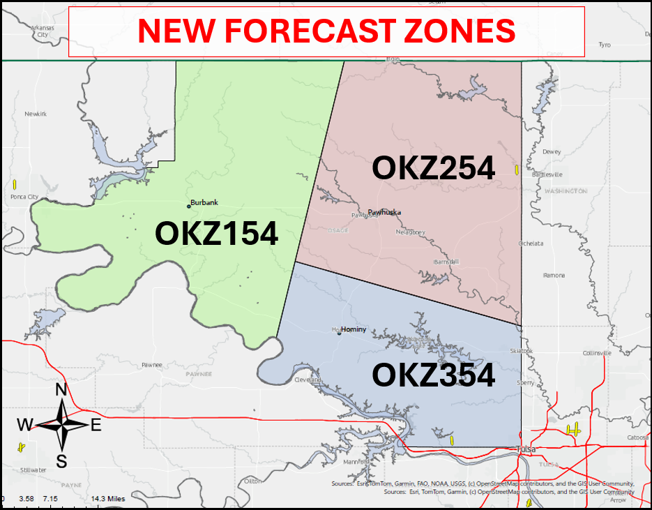 |
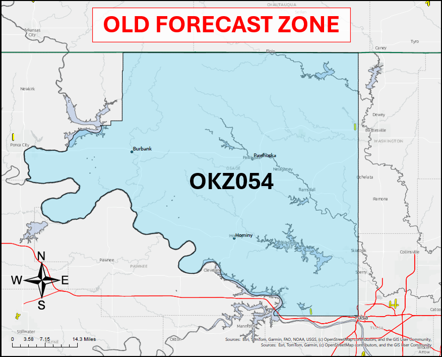
Osage County is geographically large, extending from the Tulsa metropolitan area to prairie land that reaches the Kansas border. Ozone Alerts facilitated by the Oklahoma Department of Environmental Quality for Tulsa needlessly cover rural areas well outside of Tulsa. Meteorologically, winter weather products issued for regions near the Kansas border also highlight communities and school districts near Tulsa that are not within the forecasted impacts. We will be dividing Osage County into three zones: Western Osage County, Northeast Osage County, and Southeast Osage County.
Western Osage (OKZ154)
Northeast Osage (OKZ254)
 |
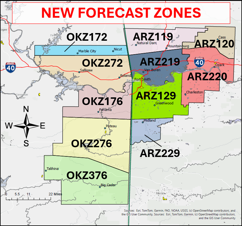 |
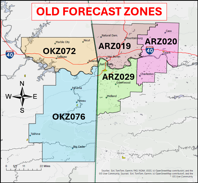
Sequoyah County contains terrain that varies from the Arkansas River Valley in the south to the beginning of Boston Mountains (Ozarks) in the north. Elevations range from near 400 feet above sea level to near 1500 feet above sea level. At times this change in terrain is important to precipitation and temperature forecasts. We will be dividing Sequoyah County into two zones: Northern Sequoyah County and Central and Southern Sequoyah County. This division will at times provide increased specificity for hydro-meteorological watches, warnings, and advisories and result in better cross-border hazard alert continuity with proposed changes in Arkansas.
Northern Sequoyah (OKZ172)
Central and Southern Sequoyah (OKZ272)
Le Flore County is geographically large, and contains terrain ranging from the Arkansas River Valley to higher elevations around 2200 feet above sea level in the Ouachita Mountains. Significant variations in temperature, wind, and precipitation occur in this county. The conditions in the higher terrain, which in southern Le Flore County contain highways and small communities, can reach hydro-meteorological advisory or warning levels when the majority of the county and population centers do not. These variations make Impact-based Decision Support Services and messaging difficult. We will be dividing Le Flore County into three zones: Northern Le Flore County, Central Le Flore County, and Southern Le Flore County. The zone division between central Le Flore County and southern Le Flore County match the zone delineation in the neighboring WFO Little Rock area.
Northern Le Flore (OKZ176)
Central Le Flore (OKZ276)
Southern Le Flore (OKZ376)
Crawford County contains terrain that varies from the Arkansas River Valley in the south to the Boston Mountains (Ozarks) in the north. Elevations range from near 400 feet above sea level to near 2000 feet above sea level. The conditions in the higher terrain, which in northern Crawford County impact Interstate 49, can reach hydro-meteorological advisory or warning levels when much of the county and population centers do not. Elevated stretches of I-49 over valleys are particularly vulnerable to winter weather conditions. By targeting winter weather headlines to the terrain, there will be times that travelers on I-40 in southern Crawford County will receive better winter weather messaging. Fire weather forecasts will be tied to the terrain and related burning conditions. Additionally, summer heat advisory and warning criteria are often met in the river valley, but not in the higher elevations. This complex terrain can make Impact-based Decision Support Services and messaging difficult. We will be dividing Crawford County into two zones: Northern Crawford County and Southern Crawford County.
Northern Crawford (ARZ119)
Southern Crawford (ARZ219)
Sebastian County contains the Arkansas River Valley in the north and the north edge of the Ouachita Mountains in the south. Elevations range from near 400 feet above sea level to near 2200 feet above sea level. The greatest variation in winter weather impacts are mostly in southern Sebastian County. This proposed change will match a previous change in areas to the east made by WFO Little Rock, enhancing continuity in hazard graphics and Impact-based Decision Support Services. We will be dividing Sebastian County into two zones: Northern and Central Sebastian County and Southern Sebastian County.
North and Central Sebastian (ARZ129)
Southern Sebastian (ARZ229)
Franklin County contains terrain that varies from the Arkansas River Valley in the south to the Boston Mountains (Ozarks) in the north. Elevations range from near 400 feet above sea level to near 2200 feet above sea level. The conditions in the higher terrain, which in northern Franklin County contain State Highways 23 and 215, can reach hydro-meteorological advisory or warning levels when much of the county and population centers do not. By targeting winter weather headlines to the terrain, there will be times that travelers on I-40 in central Franklin County will receive better winter weather messaging. Similarly, fire weather forecasts will be tied to the terrain and burning conditions. Additionally, summer heat advisory and warning criteria are often met in the river valley, but not in the higher elevations. This complex terrain can make IDSS and messaging difficult. We will be dividing Franklin County into two zones: Northern Franklin County and Central and Southern Franklin County.
Northern Franklin (ARZ120)
Central and Southern Franklin (ARZ220)

