| What is a Monsoon? PDF version |
||||
|
The word monsoon is derived from the Arabic word mausim, which means season. Traders plying the waters off the Arabian and Indian coasts noted for centuries that dry northeast winds in the winter suddenly turn to the southwest during the summer, and bring beneficial yet torrential rains to the Asian subcontinent. We now know that these large scale wind shifts, from dry desert areas to moist tropical areas, occur in other parts of the Earth, including the Oceanic subcontinent, Southeast Asia, Australia, North America, Africa and South America. |
||||
|
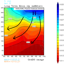
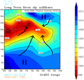
These wind shifts, and the dramatic change in weather they bring, are all more or less driven by a similar mechanism. For much of the year, low level winds in dry subtropical regions tend to blow from the land toward the sea (Graphic 1). However by late spring, strong solar heating causes temperatures to soar over these land areas. The intense heat causes surface air pressure to fall, forming an area of low pressure known as a thermal low. Adjacent large bodies of water are also warmed, but not as quickly. Thus air pressures remain high relative to the land. Eventually, the pressure difference increases to the point that the cooler and much more humid air over the ocean is drawn toward the hot, dry air over land (Graphic 2). This moist air moving onto the hot land eventually becomes unstable and develops into thunderstorms. Once this occurs and rain begins to fall, humidity levels increase over land, which only triggers more thunderstorms. This cycle will continue until land areas begin to cool in the early fall and water temperatures reach their peak in early fall. This reduces the pressure difference, which in turn causes the moist onshore flow to diminish, and the monsoon gradually ends. |
||||
|
||||
|
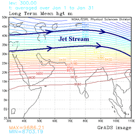
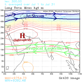
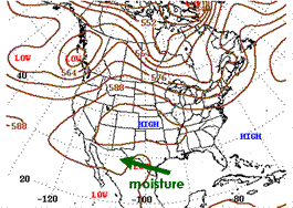
Monsoon patterns also share a similar upper level flow characteristic. As surface low pressure forms over the hot land areas, the air in the upper levels of the atmosphere also sinks and warms. The sinking air aloft forms high pressure at jet stream level and causes upper level winds to weaken. The jet stream, which blows from west-to-east around the globe, is forced toward the poles as the upper level high expands (Graphic 3). As the upper high migrates north, upper level temperatures south of the high cool slightly, while winds aloft over a monsoon region turn around to the east (Graphic 4). These easterly winds aloft import considerable moisture off nearby oceans. When combined with the low level moisture, a favorable environment for thunderstorm development is created over areas that are typically dry for much of the year. As rain begins to fall, humidity levels increase over land, triggering more thunderstorms. This cycle continues until land areas cool in early fall and ocean water temperatures reach their peak. This reduces the pressure difference and the moist onshore flow, which in turn ends the monsoon. |
||||
|
||||
| Monsoons typically occur in areas with a large, elevated landmass which further enhances temperature and pressure contrasts between land and ocean, enhances moisture transport, and supports stronger subtropical highs. All of these, in turn, enhance rainfall in monsoon regions. This explains why the Indian Monsoon is the strongest and largest. The presence of the Tibetan Plateau, which resides to the north of the Indian subcontinent, is the largest and highest elevated landmass on Earth. | ||||
| Graphics were produced using NCEP Reanalysis Derived data provided by the NOAA/OAR/ESRL PSD, Boulder, Colorado, USA. [Available on line at: Web site at https://www.cpc.ncep.noaa.gov/ ]. | ||||
|
For further reading: Holton, J.R., J.A. Curry, and J. A. Pyle (eds.), 2003: Monsoons. Encyclopedia of the Atmospheric Sciences. Elsevier Science Ltd., Oxford, UK, 3, 1365-1400. ____, 2004: The North American Monsoon. Reports to the Nation on our Changing Planet. NOAA/National Weather Service. [Available on line at: https://www.cpc.ncep.noaa.gov//products/outreach/Report-to-the-Nation-Monsoon_aug04.pdf ]
|
| The North American Monsoon PDF version |
| Until the late 1970s, there was serious debate about whether a monsoon truly existed in North America. However, considerable research, which culminated in the Southwest Arizona Monsoon Project (SWAMP) in 1990 and 1993, established the fact that a bonafide monsoon, characterized by large-scale wind and rainfall shifts in the summer, develops over much of Mexico and the intermountain region of the U.S. Published papers at the time called this pattern by different names, including the "Summer Thunderstorm Season," "The Mexican Monsoon," "The Southwest Monsoon," and the "Arizona Monsoon." |
| In 2004, a major multinational research project was conducted in northwest Mexico and the southwest U.S. The North American Monsoon Experiment (NAME) sought to better describe the monsoon in North America, and increase our ability to predict it on a daily, weekly and seasonal basis. NAME showed that despite its many names, the weather pattern we see during the summer is not only a true monsoon, but it also affects the weather over a large portion of North America. Thus the generally accepted name is now "North American Monsoon." |
| The North American Monsoon is not as strong or persistent as its Indian counterpart, mainly because the Mexican Pleateau is not as high or as large as the Tibetan Plateau in Asia. However, the North American Monsoon shares most of the basic characteristics of its Indian counterpart. There is a shift in wind patterns in summer which occurs as Mexico and the southwest U.S. warm under intense solar heating. As this happens, the flow reverses from dry land areas to moist ocean areas. In the North American Monsoon, the low level moisture is transported primarily from the Gulf of California and eastern Pacific. The Gulf of California, a narrow body of water surrounded by mountains, is particularly important for low-level moisture transport into Arizona and Sonora. Upper level moisture is also transported into the region, mainly from the Gulf of America by easterly winds aloft. Once the forests of the Sierra Madre Occidental green up from the initial monsoon rains, evaporation and plant transpiration can add additional moisture to the atmosphere which will then flow into Arizona. Finally, if the southern Plains of the U.S. are unusually wet and green during the early summer months, that area can also serve as a moisture source. This combination causes a distinct rainy season over large portions of western North America, which develops rather quickly and sometimes dramatically. Graphic 1 shows the general moisture sources for the North American Monsoon. |
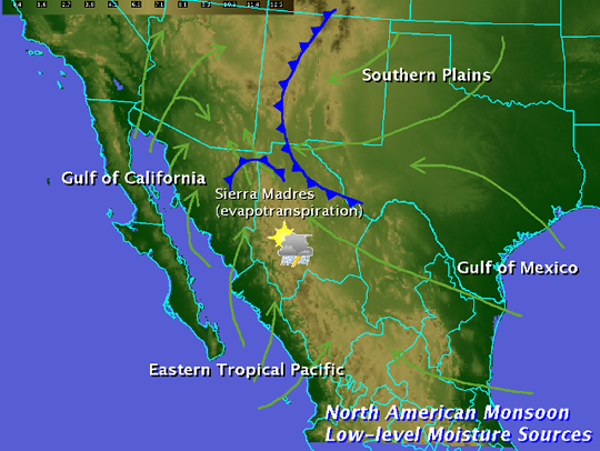 |
| Graphic 1: Moisture sources for the North American Monsoon. |
| Rainfall during the monsoon is not continuous. It varies considerably, depending on a variety of factors. There are usually distinct "burst" periods of heavy rain during the monsoon, and "break" periods with little or no rain. Monsoon precipitation, however, accounts for a substantial portion of annual precipitation in northwest Mexico and the Southwest U.S. Most of these areas receive over half their annual precipitation from the monsoon. |
| The North American Monsoon circulation pattern typically develops in late May or early June over southwest Mexico. By mid to late summer, thunderstorms increase over the "core" region of the southwest U.S. and northwest Mexico, including the U.S. and Mexican states of Arizona, New Mexico, Sonora, Chihuahua, Sinaloa and Durango. The monsoon typically arrives in mid to late June over northwest Mexico, and early July over the southwest U.S. Once the monsoon is underway, mountain ranges, including the Sierra Madre Occidental and the Mogollon Rim provide a focusing mechanism for the daily development of thunderstorms. Thus much of the monsoon rainfall occurs in mountainous terrain. For example, monsoon rainfall in the Sierra Madre Occidental typically ranges from 10 to 15 inches. Since the southwest U.S. is at the northern fringe of the monsoon, precipitation is less and tends to be more variable. Areas further west of the core monsoon region, namely California and Baja California, typically receive only spotty monsoon-related rainfall. In those areas, the intense solar heating isn't strong enough to overcome a continual supply of cold water from the North Pacific Ocean moving down the west coast of North America. Winds do turn toward the land in these areas, but the cool moist air actually stabilizes the atmosphere. |
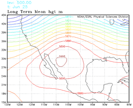
| In addition to the lower level monsoon circulation, an upper level monsoon (or subtropical) ridge develops over the southern High Plains and northern Mexico. In June, this ridge is too far south over Mexico and actually blocks deep moisture from moving north into Arizona (Graphic 2). |
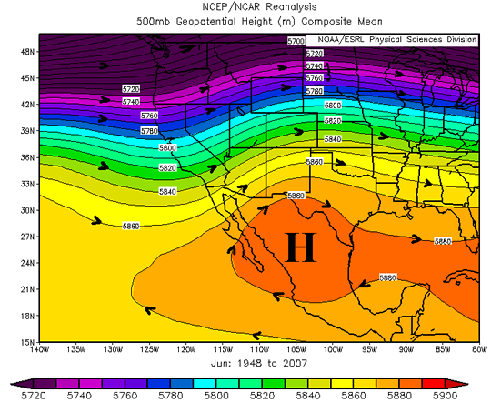 |
| Graphic 2: Mean 500mb height pattern, June. Subtropical high is strengthening over northern Mexico |
| However by late June or early July, this ridge shifts north into the southern Plains or southern Rockies (Graphic 3). As this shift takes place, mid and upper level moisture streams into Arizona, and low level moisture surges from Mexico meet less resistance. |
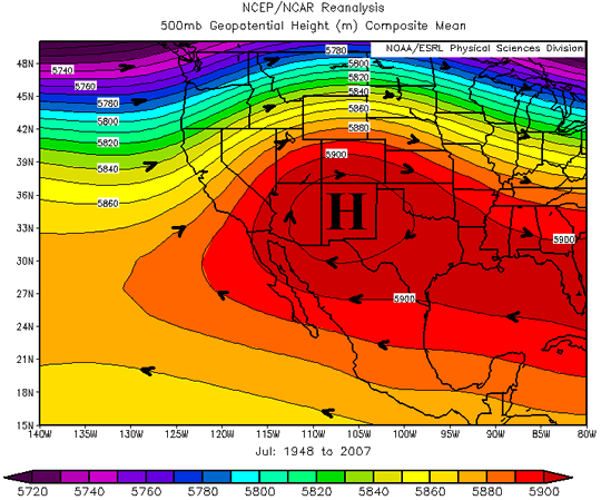 |
| Graphic 3: Mean 500mb height pattern, July. Subtropical high is near maximum seasonal strength over New Mexico. |
| This monsoon ridge is almost as strong as the one which develops over Asia during the summer. However, since the lower level moisture flow is not as persistent as in the Indian monsoon, the upper level steering pattern and disturbances around the ridge are critical for influencing where thunderstorms develop on any given day. The exact strength and position of the subtropical ridge also governs how far north the tropical easterly winds aloft can spread. If the ridge is too close to a particular area, the sinking air at its center suppresses thunderstorms and can result in a significant monsoon "break." If the ridge is too far away or too weak, the east winds around the high are inadequate to bring tropical moisture into the mountains of Mexico and southwest U.S. However, if the ridge sets up in a few key locations, widespread and potentially severe thunderstorms can develop. |
| It is important to note that the monsoon is not an individual thunderstorm. While the word "monsoon" accurately conjures up images of torrential rains and flooding, calling a single thunderstorm a "monsoon" is incorrect. A monsoon is a large scale weather pattern which causes our summer thunderstorms. |
| 500 mb graphics were produced using NCEP Reanalysis Derived data provided by the NOAA/OAR/ESRL PSD, Boulder, Colorado, USA. [Available on line at: Web site at https://www.cpc.ncep.noaa.gov/ ]. |
|
For further reading: Adams, D.K., and A.C. Comrie, 1997: The North American Monsoon. Bull. Amer. Meteor. Soc., 78, 2197-2213. Douglas, M.W., R.A. Maddox, K Howard, and S. Reyes, 1993: The Mexican monsoon. J. Climate, 6, 1665-1667. ____, 2004: The North American Monsoon. Reports to the Nation on our Changing Planet. NOAA/National Weather Service. [Available on line at: https://www.cpc.ncep.noaa.gov//products/outreach/Report-to-the-Nation-Monsoon_aug04.pdf ] Tang, M., and E.R. Reiter, 1984: Plateau monsoons of the Northern Hemisphere: a comparison between North America and Tibet. Mon Wea Rev., 112, 617-637. |
| Gulf of California Moisture Surges PDF Version |
| Gulf of California moisture surges, or simply Gulf Surges, are one of the most researched components of the North American Monsoon. As early as the 1970s, Gulf Surges were identified as a key contributor to thunderstorm development (Hales 1972; Brenner 1974). In 1990 and 1993, the Southwest Area Monsoon Project (SWAMP) was conducted to investigate these features (Reyes et al. 1994, Douglas and Li 1996). They came under even closer scrutiny during the North American Monsoon Experiment (NAME) in 2004 (Higgins, et al. 2006; Higgins and Gochis 2007). The reasons why Gulf Surges develop are varied and complex (Zehnder 2004), which makes forecasting them a challenge. However, knowing the strength, timing, duration, and amount of moisture these surges transport northward is critical to correctly forecasting thunderstorm outbreaks in the monsoon region, especially over Sonora, Arizona, and adjacent Great Basin states.. |
| During the monsoon season, water temperatures in the Gulf of California warm to 90°F (32°C). Considerable moisture evaporates into the atmosphere, with surface dewpoints occasionally climbing above 80°F (25°C). During July and August, an area of low pressure tends to linger along the Colorado River as temperatures over 105°F (40°C) cause the air to become less dense and rise. Meanwhile, cooler water off the west coast of Baja California lowers air temperatures to 85-90°F (29-32°C) at the southern end of the Gulf, and creates an area of relatively high pressure. The resulting air pressure imbalance between the two ends of the Gulf causes winds to generally blow up the Gulf during the monsoon (Figure 1). |
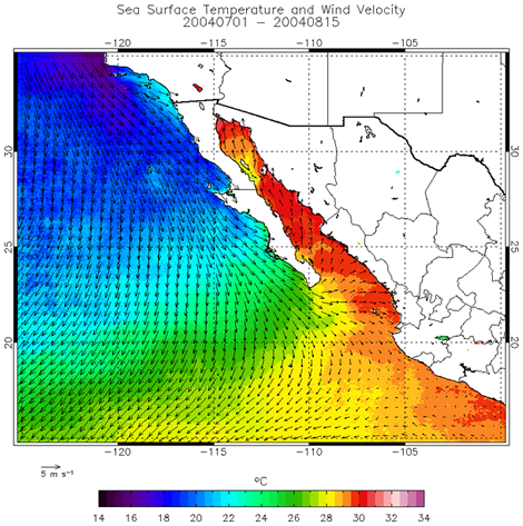 |
| Figure 1: Mean sea surface temperatures (color) and mean surface wind, 1 July-15 August 2004. From Johnson, et al. (2007). |
| Douglas (1995) and Johnson et al. (2007) both indicated that this flow typically is about 4000 feet deep, tends to be strongest between midnight and 9am MST, and weakest during the afternoon. The core of the strongest winds is typically found about 500 feet above sea level with an average speed around 18mph (8.0 m/s). This nocturnal southerly flow occasionally extends north into extreme southwest Arizona. However by the time they arrive in Arizona, the flow is usually quite shallow, develops later in the night, and dissipates earlier in the day. These limited moisture incursions then tends to dissipate during the day as daytime heating takes place and mixes the lower atmosphere. |
| However, there are certain weather conditions that can greatly enhance this low level flow, and lead to significant increases both the amount and depth of the moisture that is pushed into Arizona. There are several ways to classify Gulf Surges, but in general, Fuller and Stensrud (2000) offers a useful summary of weather changes that occur as they push north from the northern Gulf of California: |
|
| The most common way to turn the normal low level flow into a Gulf Surge is to push thunderstorm outflows into the central or northern Gulf of California. Large thunderstorm clusters develop frequently over the Sierra Madre Occidental during the monsoon, usually as an upper tropospheric low moves west across northern Mexico, or as a tropical wave passes across central Mexico. The rain falling from these thunderstorms creates areas of cool high pressure which extend into the Gulf. As long as the atmospheric pressure remains relatively low over the Colorado River Valley, the high pressure cells moving out into the Gulf will enhance the preexisting air pressure differences, will enhance the flow up the gulf, and will feed more moisture into Arizona. The rain-cooled air moving north with the outflows will also bring considerable moisture with them. These surges can get quite deep, sometimes extending up to 10,000 feet MSL. However, the areas of high pressure tend to weaken rapidly as they move away from the thunderstorms that produced them. Since these surges typically last only a few hours, they transport only limited additional moisture into Arizona. However these outflow surges, or as Adams and Comrie (1997) named them: "minor surges", can enhance thunderstorm development over Arizona, particularly if moisture is already rather plentiful, or if other triggering mechanisms are present. |
| In contrast, major surges usually involve the entire Gulf of California. It is still not entirely clear how these surges initiate, but extensive research has shown that a strong disturbance near the mouth of the Gulf of California, usually a tropical cyclone or tropical wave, can force more air into the southern Gulf of California than usual. The push of slightly cooler air apparently starts a complex process where an intense atmospheric wave, or series of waves, is forced up the Gulf between the two mountain ranges on either side. These waves can move at over 30 mph, and greatly enhance the typical low level flow. Winds as high as 50 mph have been detected just a few hundred feet above the surface with the strongest surges, and despite being rather shallow, this enhanced, moisture-laden, low level flow can push deep into Arizona. Instead of mixing out like thunderstorm outflows, these surges can continue well into the day, and can even continue over a couple of days. An example of a strong Gulf Surge, which is described in detail by Rogers and Johnson (2007) is shown in Figures 2 and 3. |
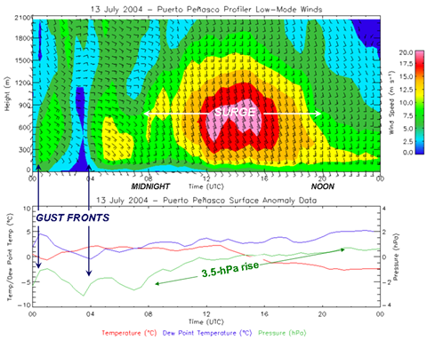 |
| Figure 2: Weak outflow Gulf Surges are followed by a strong (gravity wave) Gulf Surge at Puerto Peñasco, Sonora, 13 July 2004. Note the 20 m/s (45mph winds) just above the surface between 12 UTC (5am MST) and 19 UTC (Noon MST). [NAME data repository on line at http://www.eol.ucar.edu/projects/name] |
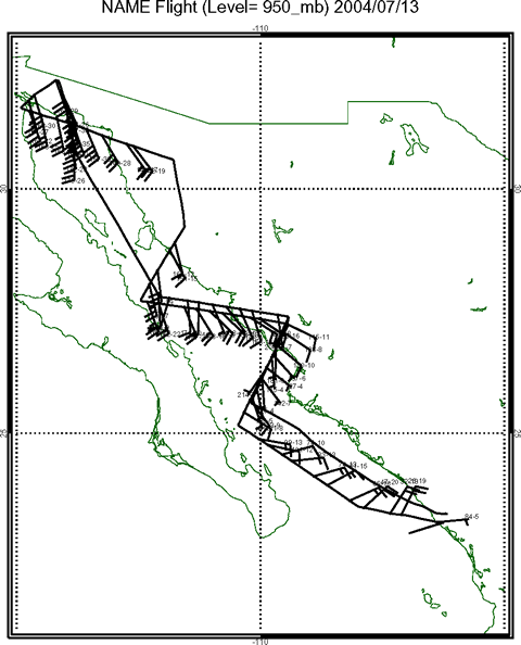 |
| Figure 3: NOAA-P3 aircraft data from a Gulf Surge on 13 July 2004. Winds are at 950mb/about 1000ft above sea level. East winds at the southern end were from outflows pushing off the Sierra Madres and a tropical storm well to the south. Farther north, the winds were accelerating from 20-30mph at mid-Gulf to 35-45mph at the northern tip. (NAME data repository) |
| Strong surges, especially if they last for at least 12 hours, can cause surface dewpoints in the Arizona deserts to soar above 65°F, and sometimes as high as 75°F. However, the more humid airmass also does not heat up as much as a drier airmass. Surges also bring the slightly cooler air temperatures from the Gulf into the state. Thus on the same day a surge pushes into the deserts, afternoon temperatures may be held down by a few degrees. That can actually suppress thunderstorm development despite the significant humidity increase. Eventually though, usually by the next day, as the moist and relatively cool air mixes deeper into the atmosphere, the deserts once again heat up, while the additional moisture brought into Arizona by the surge, provides the fuel for widespread thunderstorms and heavy rain. |
| References: |
|
Adams, D.K., and A.C. Comrie, 1997: The North American Monsoon. Bull. Amer. Meteor. Soc., 78, 2197-2213. Brenner, I.S., 1974: A surge of maritime tropical air - Gulf of California to the Southwestern U.S. Mon Wea Rev, 102, 375-389. Douglas, M.W., 1995: The summertime low level jet over the Gulf of California. Mon. Wea. Rev., 123, 2334-2347. Douglas, M.W., and S. Li, 1996: Diurnal variation of the lower tropospheric flow over the Arizona low desert from SWAMP-1993 observations. Mon. Wea. Rev., 124, 1211-1224. Fuller, R.D. and D.J. Stensrud, 2000: The relationship between tropical easterly waves and surges over the Gulf of California during the North American Monsoon. Mon Wea. Rev., 128, 2983-2989. Hales, J.E.: Surges of maritime tropical air northward over the Gulf of California. Mon Wea Rev, 100, 298-306. Higgins, R.W., and Coauthors, 2006: The North American Monsoon Experiment (NAME) 2004 field campaign and modeling strategy. Bull. Amer. Meteor. Soc., 87, 70-94. Higgins, R.W., and D Gochis, 2007: Synthesis of results from the North American Monsoon Experiment (NAME) process study, J. Climate, 20, 1601-1607. Johnson, R.H., P.E. Ciesielski, B.D. McNulty, P.J. Rogers, and R.K. Taft, 2007: Multiscale variability of the flow during the North American Monsoon Experiment. J. Climate, 20, 1628-1648. Reyes, S., M.W. Douglas, and R.A. Maddox, 1994: El Monzon del suroeste de Norteamérica (TRAVASON/SWAMP). Atmósfera, 7, 117-137. Rogers, P. J. and R.H. Johnson, 2007: Analysis of the 13-14 July gulf surge event during the 2004 North American Monsoon Experiment. Mon. Wea. Rev., 135, 3098-3117. Zehnder, J.A., 2004: Dynamic mechanisms of the gulf surge. J. Geophys. Rea., 109, D10107, 14pp. |
| Southeast Arizona Monsoon Progression? PDF version |
||||||
| No two years are ever alike weather-wise, and the same can certainly be said about the monsoon. However the monsoon ebbs and flows in a relatively predictable cycle each year across Arizona, with five broadly-defined phases. These phases depend heavily on where the subtropical (monsoon) ridge is located, and how strong it is. | ||||||
| Many tools are used to track these trends, but the single best method is to monitor the height of the 500mb atmospheric pressure. This 500mb height, usually expressed in meters above sea level, indicates how strong the monsoon ridge is, where it is centered, and how warm it is underneath. A height above 5950m is indicative of a strong monsoon ridge with hot temperatures underneath. It also tends to lead to stronger easterly flow aloft south of the ridge. A height below 5880m is indicative of a weak monsoon ridge, with slightly cooler temperatures underneath. It also means weaker easterly winds south of the ridge, and the tendency for the high to shift south and allow drier westerly winds aloft to penetrate into the monsoon region. | ||||||
| Ramp-Up: Mid June through early July | ||||||
| By mid June, the flow of tropical moisture has begun into the Sierra Madres in southern Chihuahua, Durango and Sinaloa, Mexico. The monsoon ridge has formed, is strengthening, and is expanding north into the Rio Grande Valley. This causes upper level winds over southeast Arizona to turn from the southwest or west to the southeast or east. The shift begins to spread upper level subtropical moisture from the Gulf of America into northwest Mexico and the southwest U.S. Isolated thunderstorms develop, mainly during the hottest part of the day in late afternoon. The lower levels of the atmosphere remain dry, though, so most of the rain from these mainly mountain thunderstorms evaporates before reaching the ground. Instead, the storms produce strong, gusty and highly variable winds, and dry lightning. By this time, the mountain forests have not received precipitation since April, so both live and dead vegetation is at its driest. Thus the risk of wildfires is at its highest as well. | ||||||
| A few of these weakening thunderstorms may be pushed by the winds aloft into the lower deserts during the early evening hours. As the rain from these thunderstorms evaporates into the hot, dry desert air, it cools and accelerates downward to the surface. This is known as a microburst. Microbursts, while only a mile or two across, can be accompanied by damaging wind gusts exceeding 70 mph. As these gusts strike the desert and valley floors, a dust storm, or haboob, can occur. Dust storms like this can reach great heights and travel dozens of miles away from the thunderstorm. Within the dust storm, visibilities can drop to near zero. | ||||||
| In this ramp up phase, the monsoon ridge can shift back to the south, and cause a temporary return to hot, dry, early summer weather. This "false start" can be problematic if wildfires have been ignited, since the return to very low humilities is usually accompanied by stronger winds. Once every few years, though, the low level moisture does not lag behind the upper level moisture. Instead, the low level moisture surges into Arizona from the subtropical rain forests of the southern Sierra Madres, up the Rio Grande Valley, or up the Gulf of California. If that happens, we can entirely skip this phase and jump to the Onset Phase. | ||||||
|
||||||
| Onset: late June through mid July | ||||||
| As moisture increases over northern Mexico, and thunderstorms become a daily occurrence over the Sierra Madres just south of the Arizona border, dramatic changes take place in the mountain landscape. Areas that were brown and dry in spring and early summer rapidly green up as semitropical trees begin to soak up recently-fallen monsoon rains and sprout canopies of leaves. These trees, shrubs and grasses, combined with the wet soils, put considerable moisture into the atmosphere through evapotranspiration. Meanwhile, the monsoon ridge continues to strengthen and move northward into the southern Plains of the U.S. By now, winds aloft over southeast Arizona are solidly out of the east or southeast. Moisture spreads into the region not only aloft, but also at the surface. Surface dewpoints are usually the last weather parameter to reach critical values as the monsoon arrives in earnest. | ||||||
| At this stage, the deserts are still relatively hot and dry. However, the thunderstorms become much more organized, more numerous, and produce more rain. They start developing earlier in the afternoon, and may continue to grow and organize into the evening hours as they move west or northwest more easily. Severe weather becomes an even greater concern as the damaging winds being to affect larger areas. Dust storms and microbursts may still occur, especially as the storms spread north and west toward Phoenix and the low deserts. However, as the first heavy rains begin to fall on the deserts, dust storms become less common as the risk of flash flooding increases. | ||||||
|
||||||
| Peak: mid July through mid August | ||||||
| This is monsoon prime-time in southeast Arizona. The monsoon high is at its strongest and northernmost extent in the four corners region of the U.S. This high can meander over the region, and at times may even shift into the Great Basin. Steering winds aloft are persistently out of the east over southern Arizona, and may even turn to the northeast. If the monsoon ridge is unusually weak or is pushed south by an unseasonably strong storm in the Pacific Northwest, monsoon "breaks" can occur as the upper level winds weaken and fail to bring additional moisture into the region. | ||||||
| Two particular phenomena can also take place and cause heavy "burst" periods of rainfall. First, there are occasional low-level moisture surges from the Gulf of California, which by now has water temperatures approaching 90° F. These Gulf Surges travel up the Colorado River Valley and low deserts of Arizona, sometimes even reaching Utah and Nevada. Second, upper level disturbances rotating around the subtropical high pass rather regularly across southern Arizona and Sonora. These create a more favorable atmospheric environment at upper levels for thunderstorm development. When one or both of these conditions occur, thunderstorms moving westward off the mountain ranges and into the low deserts may continue to grow and organize, instead of decaying. The favorable upper level environment can also affect the timing of thunderstorm development. Instead of the typical development in the afternoon, thunderstorms can occasionally develop in the middle of the night, early in the morning, or redevelop repeatedly over the same general area. With the increased moisture, and more focusing mechanisms in the upper atmosphere, flash flooding becomes the main concern. Dry microbursts are unusual during this time, but the rain can be so heavy (sometimes falling at the rate of 4 inches per hour) that the down-rushing, cold rain and even hail can produce damaging winds on their own. | ||||||
|
||||||
| Late Monsoon: mid August through early September | ||||||
| It is unusual for the monsoon to end abruptly. By mid August, the increasingly lower sun angle in the northern hemisphere becomes less effective in maintaining the monsoon ridge. The high begins to retreat southeast into the southern Plains and can even break into pieces as the polar jet stream begins to shift south from Canada. Upper level winds become more variable, and sometimes turn to the south or even southwest. Breaks become longer between thunderstorm events. However, the combination of wet soils and continued rain over Mexico usually keeps low level moisture in place over Arizona. Because steering winds become more variable and sometimes light, thunderstorms can still be slow-moving and pose a serious flash flood threat, particularly in places where it has been wet all summer. | ||||||
| This is the time of year where the tropical eastern Pacific becomes a concern. Very warm water temperatures support tropical storms and hurricanes west of the Mexican coast. Most of these hurricanes move harmlessly west into the open Pacific. However as the monsoon ridge shifts south, moisture from these systems can be steered toward Arizona. When this happens, thunderstorm rains can be enhanced and lead to flash flooding. | ||||||
|
||||||
| Decay: late August-late September | ||||||
| By September, the subtropical ridge has weakened considerably, while the jet stream continues to strengthen and shift deeper into the U.S. Winds aloft begin to blow more consistently from the southwest and work their way to the surface. Unless a tropical system is captured, this southwest flow disrupts both the upper and lower level moisture feed into Arizona. The soils begin to dry out, and temperatures begin to cool while remaining relatively warm aloft. The lack of low level moisture and a more stable atmosphere causes thunderstorm activity to diminish and the monsoon to fade. | ||||||
| In this decay phase, though, the weather can still turn active. Moisture lingering from earlier in the summer remains over Mexico until early October. If any incoming cold fronts from the Pacific tap into this moisture, thunderstorms will redevelop. This can be a dangerous time since the cold fronts are usually accompanied by colder air and stronger winds aloft. This situation, which is more typical for the Plains states, can lead to rotating, supercell storms. Although Arizona only sees a few tornadoes a year, they are most likely to occur during this transition period. | ||||||
| Once every 2 to 3 years, an east Pacific tropical storm or hurricane is steered into Arizona, either by an incoming Pacific storm system, or by the weakening subtropical high over Mexico. Most of the time, these systems dissipate before reaching the border. However, they can induce moisture surges into Arizona and support larger areas of heavy rain. About once every 10 years, a system survives long enough to actually cross into Arizona as a minimal tropical storm. In either case, torrential rains and flooding can result as the monsoon winds down. | ||||||
|
| Monsoon Inter-annual variability? PDF version |
||||
|
Monsoon variability from one summer to the next is substantial, and exceeds the normal monsoon seasonal precipitation at most locations. For example, the normal monsoon precipitation at Tucson, AZ is 6.06 inches. The driest monsoon season measured 1.59 inches, and the wettest measured 13.84 inches. Therefore a variation between seasons of 12.25 inches exists, which is over twice the normal monsoon precipitation at Tucson. Understanding the causes for this huge variation is the first step in developing an ability to forecast an upcoming monsoon season. |
||||
| Research within the past decade or so has investigated the possible causes behind North American Monsoon variability. Specific factors examined include: | ||||
|
||||
| All of these research factors uncovered important details affecting the monsoon in the Southwest, but none of them provided a perfectly clear picture of all conditions affecting its variability. These factors are related to each other and are not independent. For example, sea surface temperatures affect all the other factors to some extent. In additional to inter-annual monsoon variability, multi-decadal variability has been observed. In other words, data from 1963 through 1996 may show results in one aspect, while larger data sets from 1900 through 1963 uncover results not seen in the later time periods. | ||||
| The role of sea surface temperature anomalies: | ||||
|
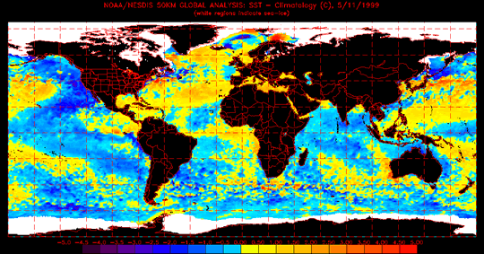
From a climatic perspective, an important factor to examine in any precipitation regime is the surrounding sea surface temperatures (SSTs). Atmosphere-ocean coupling is a strong driver in many seasonal patterns observed around the globe. The El Nino/Southern Oscillation is perhaps the most well known. Sea surface temperature anomalies (SSTAs) are the primary data set used in these studies. SSTAs can be statistically correlated to many observed conditions such as precipitation, maximum temperature or snow cover, and SSTs vary slowly when compared to changing weather patterns. Monsoon variability research shows that Pacific SSTs are an important factor in determining summertime drought or rainy conditions in both the Southwest and the Great Plains. Additionally these Pacific SSTs help modulate the previous winter season precipitation amounts. These analyses show winters preceding early-onset monsoons are characterized by cold SSTA in the mid-latitudes of the North Pacific and warm SSTA in the subtropics of the North Pacific; the opposite is true for late onset monsoons. The SSTA analysis shown in Figure 1 depicts a typical early onset monsoon pattern. Blue colors represent colder than normal temperatures; yellows and reds represent warmer than normal. The actual temperature scale in degrees Celsius is given at the bottom. |
||||
 |
||||
| Figure 1: Sea surface temperature anomalies with cooler than normal temperatures (blue) off the western U.S. Cooler water in this location is typical of an early onset monsoon pattern. | ||||
| A significant correlation exists in the observed data such that wet winters are generally followed by dry monsoons, and dry winters are generally followed by wet monsoons. Dry and wet conditions are classified as the bottom or top 25% of the years examined. Therefore the Southwest summer rainfall is modulated by the Pacific SSTs. Unfortunately SSTs are not the only factor involved, since 16 consecutive wet (dry) winters and wet (dry) monsoons have been observed in the past 100 years. Likewise near normal winter or monsoon precipitation, the middle 50% or half of the years examined were unrelated to each other. | ||||
| The role of the large scale circulation | ||||
| The North American monsoon is closely linked to the large scale (continental) weather patterns over the United States. The monsoon onset is connected with a shift in the Bermuda high toward the west, which in turn provides light easterly flow at mid and upper levels into Mexico and the Southwest. The exact location of the summertime ridge over the United States is a big factor in monsoon variability from one year to the next. Additionally the location of this ridge is affected by SSTs in the months of May of June. These two figures illustrate an idealized relationship between the ridge location and the character of monsoon observed over the Southwest. | ||||
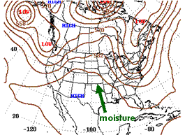
| Two idealized configurations of the ridge exist. The first configuration (Figure 2) has a strong ridge located in the Great Plains. Upper level easterlies carry moisture and disturbances from the Gulf of America south of the ridge. In this configuration the monsoon arrives early in the Southwest and is wet. The second configuration (Figure 3) centers the ridge in northwest Mexico because a trough occurs in the western U.S. This situation directs moisture into the Great Plains. The Southwest is dry and monsoon onset is late. | ||||
|
||||
| Another important concept in examining the large scale circulation is the thermal contrasts between the land and sea. This thermal contrast is what establishes a large scale thermally direct circulation of hot, rising air over the continent and cooler, sinking air over the ocean. The monsoon thermally driven circulation is physically similar to a sea breeze observed near an ocean or lake, except on a much larger scale. | ||||
| The North Pacific sea surface temperature patterns affect these large scale circulations by influencing the summer precipitation in the Great Plains. Warmer water in the eastern North Pacific favors a ridge in that area with a trough over the West. Conversely cold water in the eastern North Pacific supports a strong ridge in the Great Plains. Many studies have found a strong relationship between the Southwest and the Great Plains. During the summertime, when the Great Plains is persistently wet, the Southwest will tend to be dry. If the Great Plains is experiencing a summer drought, the Southwest will tend to be wet. This reversal of phase observation is directly related to the large scale circulations present, and is a factor in monsoon variability from one year to the next. | ||||
| The role of land surface conditions | ||||
| A significant correlation exists in the observed data such that wet winters in the Southwest are generally followed by dry monsoons, and dry winters are generally followed by wet monsoons. One of the possible physical explanations for this observation is found in examining the spring snow pack in the southern Rocky Mountains. A heavy snow pack in southern Utah and Colorado may delay the development of the summer ridge over the U.S. because more solar energy goes toward melting snow instead of heating the atmosphere necessary to build the monsoon ridge. A statistical analysis of this feedback indicates it influences western New Mexico the most and to a lesser extent Arizona and the Plains. | ||||
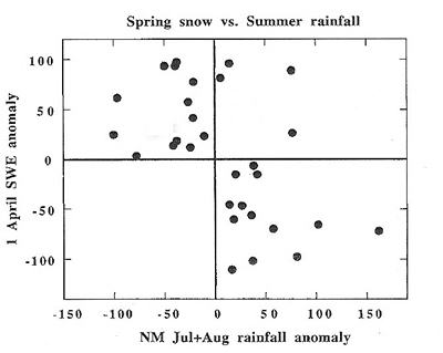
| Figure 4 illustrates the relationship between spring snowfall and summer rainfall in New Mexico. Solid dots above the horizontal center line occur when the water equivalent of the spring snow pack is above normal. Below the center line indicates less than normal snow pack. The vertical center line differentiates above (right of line) or below (left of line) normal monsoon rainfall. As you can see, most of the solid dots occur in the upper left quadrant (above normal snow, below normal rainfall) and lower right quadrant (below normal snow, above normal rainfall). These data are from a 30 year period 1961 to 1990. | ||||
 |
||||
| Figure 4: Snow water equivalent (SWE) on April 1 plotted with the amount of New Mexico rainfall observed that year in July and August (from Gutzler, 2000). | ||||
| The evolution of the monsoon as it develops over North America is characterized by the rains starting in southwest Mexico in May and moving northward into the U.S. by July. As the rains move northward, a rapid green up in vegetation is observed and is associated with this increase in precipitation. The abundant vegetation then improves the ability for moisture to remain in the lower levels of the atmosphere, due to transpiration by plants, and assists the moisture moving northward. Drier lower levels in the atmosphere can impede moisture movement, since much of the rainfall evaporates before it reaches the ground. Hence the lower levels never reach saturation. These monsoon moisture conditions remain until a large-scale circulation pattern change occurs and dries out the atmosphere. The effect of vegetation on atmospheric moisture is most important during the latter part of the monsoon in August and September. | ||||
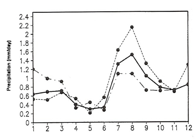
| Given this evolution of the monsoon, a question arises: does an early start in Mexico imply an early start in the Southwest? This question is important because an early start to the monsoon in the Southwest invariably leads to a wet monsoon. Therefore, if we know what is happening in Mexico we may be able to anticipate what happens in Arizona and New Mexico A late start often has a "sputtering" monsoon with below normal precipitation. Figure 5 depicts how the start date affects the amount of precipitation received and was created using data from 1963 to 1988. | ||||
 |
||||
| Figure 5: Precipitation amounts received in Arizona and New Mexico throughout a year. Dash-dot line represents dry monsoons; dashed line wet monsoons and the solid line is a composite of all monsoons (from Higgins, 1999). | ||||
| In Figure 5 the dashed line represents wet monsoons, the dash-dot line represents dry monsoons and the solid line is a composite of all monsoons. Additionally Figure 5 illustrates the relationship between a dry winter/wet monsoon and wet winter/dry monsoon. | ||||
| Coming back to the question about how an onset date in Mexico relates to Arizona and New Mexico; the answer is no relationship exists between the southwest Mexico onset date and seasonal rainfall anomalies. Thus an early monsoon start in Mexico is not related to the monsoon precipitation characteristics elsewhere. | ||||
| The role of the inter-tropical convergence zones | ||||
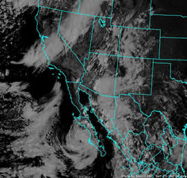
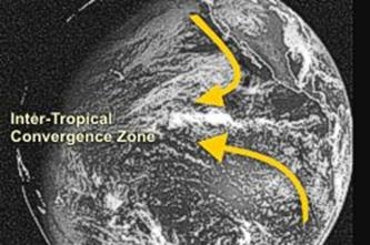
| The inter-tropical convergence zone (ITCZ) is an area of convection located between 5o and 10oN as shown in Figure 6. On a satellite picture, the ITCZ appears as an area of thunderstorms north of the equator. The activity in this zone off the coast of Mexico during the spring directly impacts the type of monsoon observed. For example, a wet monsoon in the Southwest is associated with suppressed precipitation in the eastern Pacific ITCZ and enhanced precipitation north and south of this zone. Likewise an active ITCZ area during the spring preceding monsoon onset is indicative of a dry monsoon. | ||||
| The shifts in the ITCZ can be affected by sea temperatures. Warmer temperatures favor a stronger and more southward displaced ITCZ off the Mexican coast. Cooler temperatures tend to weaken the convergence zone and displace it further north. Thus cooler sea surface temperatures can both increase the land-sea temperature gradient and inhibit the ITCZ; warmer SSTs have the opposite effect. | ||||
 |
||||
| Figure 6: Visible satellite picture illustrating an inter-tropical convergence zone. | ||||
| The physical reason behind the ITCZ/monsoon interaction is not entirely clear. A tropical convergence zone is maintained by lower level westerly winds from the equator colliding with lower level easterly winds from the northern latitudes. The stronger the intensity of these winds, the stronger the storms in this convergence zone. When ITCZ activity off the southern coast of Mexico is weak, a plausible explanation related to the monsoon is that the land-sea interactions associated with the monsoon can more easily develop. Moisture and abundant rainfall then enters southern Mexico under these conditions. A strong ITCZ inhibits this critical circulation pattern from developing over Mexico. | ||||
| The role of moisture transport | ||||
| Moisture entering the Southwest during the North American Monsoon generally comes from two locations, the Gulf or Mexico or the Gulf of California. Analysis data shows mid and upper level moisture primarily originates from the Gulf of America, while lower level moisture advection originates from the Gulf of California. Of course, once thunderstorms start in Arizona or New Mexico, all levels of the atmosphere become moist. However the variability of where this moisture originates in the first place helps explain the variability from one monsoon to the next. | ||||
| Local sea surface temperatures (SSTs) are an important aspect of this moisture transport. Research has shown that roughly 80% of the rainfall in Arizona and New Mexico occurs after SSTs in the northern Gulf of California exceed 28.5oC. Likewise positive correlations with SST anomalies over the Gulf of America have been found too. Hence the warm water in these areas increases the availability of moisture to be transported elsewhere. | ||||
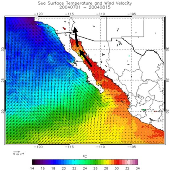
| One common method for transporting moisture from one place to another is by increasing the low level winds. Regions of lower level wind speed maximum are referred to as lower level jets. Two lower level jets exist affecting the Southwest; one in the Gulf of California and another over the Great Plains. A lower level jet coming up the Gulf of California directly transports moisture into Arizona and is called a gulf surge. One factor affecting the variability of moisture transport in the Gulf of California is the SSTs along the California and northern Baja coasts. An increased thermal gradient in this region promotes the formation of lower level jet episodes as shown in Figure 7. | ||||
 |
||||
| Figure 7: Cooler sea surface temperatures off the Baja coast is a favorable condition for moisture transport from the Gulf of California into Arizona and California. | ||||
| The lower level jet in the Great Plains primarily determines the type of summer precipitation over Texas, Oklahoma and Kansas. The eastern portion of New Mexico may directly experience affects from the Great Plains lower level jet moisture, but most of the Southwest does not. The importance of this jet is that it weakens when the large-scale circulation pattern reduces precipitation in the Plains. Instead of moving north, this moisture gets shunted into Mexico and eventually into the Southwest as the source of mid and upper level moisture. | ||||
 |
||||
| Figure 8: Warm sea surface temperatures in the Gulf of America which can promote mid and upper level moisture transport into the Southwest. | ||||
| Climate Change and the Monsoon | ||||
| A question of concern is how the North American Monsoon will be altered in the future as a result of climate change. Global warming projections are given by numerical computer models, such as those documented by the Intergovernmental Panel on Climate Change. Unfortunately the IPCC models poorly represent the North American Monsoon in the Southwest. Hence this question does not have an accurate answer at this time. | ||||
| Summary | ||||
| Many factors influence the variability from one monsoon season to the next. All of these factors are inter-related to each other, and likewise none of them totally account for monsoon variability. The scientific understanding of this variability has increased substantially over the past 15 years and remains an active research area. | ||||
| Further Reading and References: | ||||
| Carleton, et.al., 1990: Mechanisms of Interannual Variability of the Southwest United States Summer Rainfall Maximum. J. Climate, 3, 999-1015.
Castro, C.L., McKee, T. B. and Pielke, R.A., 2001: The Relationship of the North American Monsoon to Tropical and North Pacific Sea Surface Temperatures as Revealed by Observational Analyses. J. Climate, 14, 4449-4473. Castro, C.L., Pielke, R.A. and Adegoke, J.O., 2007: Investigation of the Summer Climate of the Contiguous United States and Mexico Using the Regional Atmospheric Modeling System (RAMS). Part I: Model Climatology (1950-2002). J. Climate, 20, 3844-3865. Castro, C.L., Pielke, R.A. and Adegoke, J.O., 2007: Investigation of the Summer Climate of the Contiguous United States and Mexico Using the Regional Atmospheric Modeling System (RAMS). Part II: Model Climate Variability. J. Climate, 20, 3866-3887. Gutzler, David and Preston, Jessica, 1997: Evidence for a relationship between spring snow cover in North America and summer rainfall in New Mexico. Geophysical Research Letters, 24, 2207-2210. Gutzler, David S., 2000: Covariability of Spring Snowpack and Summer Rainfall across the Southwest United States. J. Climate, 13, 4018-4027. Higgins, R.W., Mo, K.C. and Yao, Y., 1998: Interannual Variability of the U.S. Summer Regime with Emphasis on the Southwestern Monsoon. J. Climate, 11, 2583-2606. Higgins, R.W., Chen, Y. and Douglas, A.V., 1999: Interannual Variability of the North American Warm Season Precipitation Regime. J. Climate, 12, 653-679. Higgins, R.W. and Shi, W., 2000: Dominant Factors Responsible for Interannual Variability of the Summer Monsoon in the Southwestern United States. J. Climate, 13, 759-776. Higgins, R.W. and Shi, W., 2001: Intercomparison of the Principal Modes of Interannual and Intraseasonal Variability of the North American Monsoon System. J. Climate, 14, 403-417. Mo, Kingtse C. and Paegle, Julia Nogues, 2000: Influence of Sea Surface Temperature Anomalies on the Precipitation Regimes over the Southwest United States. J. Climate, 13, 3588-3598. Vera, C. et. al., 2006: Toward a Unified View of the American Monsoon Systems. J. Climate, 19, 4977-5000. |
| Summer Severe Thunderstorm Patterns in Arizona. PDF version |
| In the 1990s, three general, large-scale weather patterns were identified which are favorable for producing severe thunderstorm and flash floods in central Arizona. (McCollum 1993, Maddox et al. 1995). Because of the lack of a dense, statewide severe weather spotter network, the research focused on mainly the Phoenix Metro Area. It also focused on just July and August from 1978 to 1990. Since then, a much better spotter network and rapid population growth has greatly expanded our severe weather database, particularly in the southeast and along the Mogollon Rim. The new data has confirmed that these three patterns support severe thunderstorm and flash flood outbreaks over much of the state. However, the additional data suggest that a fourth pattern, which tends to occur late in the monsoon season, produces its share of damaging winds, hail and flash flooding as well. |
| Type I: Southern Plains/Four Corner High |
| This is the most common severe thunderstorm pattern for southeast and south central Arizona, especially early in the monsoon. In this situation the monsoon ridge sets up over the southern Plains and extends west to the Arizona-Utah border. A secondary high usually develops near the Four-Corner region. When this happens, mid level temperatures across southern Arizona cool, low level moisture increases from the south or east, and winds between 10,000 and 20,000 feet increase out of the east. This causes thunderstorms to tilt slightly, and allows them to maintain themselves for longer periods of time while organizing into lines or clusters. If the lower levels of the atmosphere are rather dry, straight line winds and dust storms are a major concern. If the lower levels are moist, flash flooding becomes a problem as well. |
| Initially, thunderstorms on Type-I days form on the mountains and spread east-to-west or southeast-to-northwest. Thunderstorms on the Mogollon Rim and in the White Mountains tend to remain where they develop, while the storms in the mountains of southeast Arizona or northern Sonora tend to move into the valleys and eventually the low deserts. As these storms move progressively farther to the north or the west, they typically encounter a more stable atmosphere and dissipate. When a Gulf Surge is underway, though, the atmosphere remains unstable as the storms move into the lower deserts. In these instances, storms may continue to travel all the way to the Colorado River Valley. |
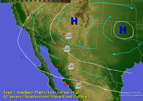 |
| Type I: Southern Plains / Four Corner High |
| Type II: Great Basin High |
| This severe thunderstorm pattern is less common, and tends to occur during the height of the monsoon. In this situation the monsoon high migrates unusually far northwest into the Great Basin of southwest Utah or southern Nevada. Over the eastern U.S., an unusually deep upper level trough develops which sometimes pushes a cold front south through the Plains and west toward the Arizona-New Mexico border. The clockwise circulation around the upper level high causes winds between 10,000 and 18,000 feet increase out of the northeast over Arizona. |
| As the thunderstorms develop on the mountains, the Mogollon Rim readily forces them to organize into squall lines, which are then pushed southwest by the winds aloft into the deserts. The northeast winds aloft usually bring drier air into Arizona, so if the drying is deep enough, the thunderstorms may dissipate before moving very far away from the higher terrain. However, if there is only drying aloft and low level moisture remains plentiful, the downdrafts associated with these lines of storms can become large and severe. Areas most susceptible to Type II events are those immediately downwind from the Rim or White Mountains of east central Arizona, including: the Phoenix Metro Area, the Gila River Valley, and the valleys of Yavapai County. The changing wind direction and speed with height also helps to sustain the thunderstorms for even longer periods than in Type-I patterns, which can allow them to persist well into the night as they move southwest through Tucson and the Colorado River Valley. |
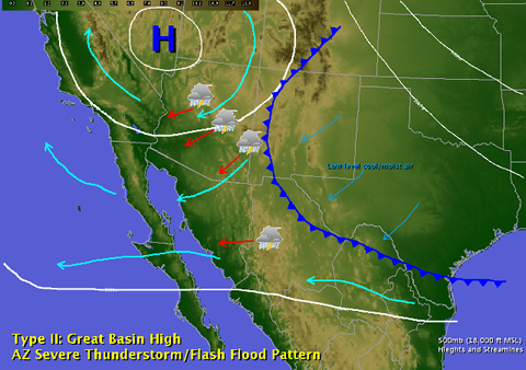 |
| Type II: Great Basin High |
| Type III: Trapping High |
| This pattern is quite different than the other two in that the monsoon ridge is weaker and suppressed father to the south - sometimes extending along the U.S.-Mexican border. The ridge will sometimes break into two separate centers with one over south Texas and the other over northern Baja. If this occurs either in June or September, the ridge placement tends to block moisture coming north from Mexico. However during monsoon peak, moisture still finds its way into Arizona from the south and east. Meanwhile, upper level disturbances can move into the region from several different directions, and either slow down, or become trapped within the ridge and stall. The presence of a weak upper low keeps temperatures aloft relatively cool, and the entire atmosphere unstable. |
| Winds aloft in Type III patterns are usually very light. Though thunderstorms are not particularly well organized due to the lack of wind shear, they tend to move slowly or remain relatively stationary. Moisture becomes trapped over the region, which only causes more slow-loving thunderstorms to develop. This rather stagnant situation will end when either the high strengthens and causes mid level temperatures to warm, or winds aloft increase. |
| This pattern, which tends to develop most often in late July or August, can result in flash flooding and isolated. In fact, the atmosphere can remain so moist and unstable that thunderstorms may not follow the typical diurnal pattern of developing in the afternoon and fading a couple of hours after sunset. The most notorious and recent example of what this pattern can do occurred between July 26 and August 1, 2006. An upper level disturbance stalled between breaks in a weak monsoon ridge along the International Border. Widespread flash flooding plagued much of Arizona for several nights in a row which resulted in millions of dollars in damage. |
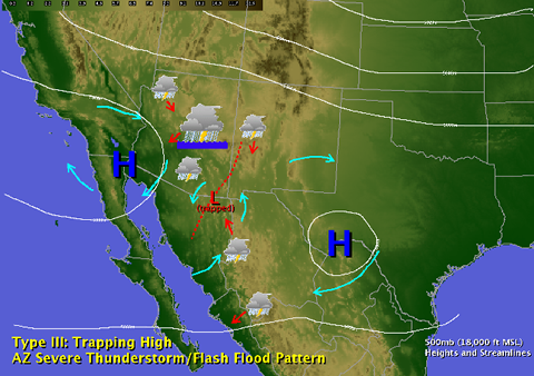 |
| Type III: Trapping High |
| Type IV: Transitional |
| This pattern does not need the monsoon itself to generate severe weather in Arizona. It tends to develop sometime in late August or September, and usually acts on moisture that was transported into Arizona during the monsoon season. This pattern is called "transitional" because winds aloft shift from the tropical easterlies back to the southwest or west. This typically happens as the subtropical high weakens and shifts southeast into northern Mexico or the Gulf of America, and a trough of low pressure develops near the West Coast. This trough is sometimes accompanied by a weak surface cold front, which helps to organize thunderstorms development. |
| Surface winds ahead of these upper level troughs usually remain out of the south or southeast, while upper level winds shift to the southwest or west. The resulting wind shear can cause squall lines, or rotating, supercell thunderstorms to develop. This pattern is actually similar to the conditions that trigger severe weather in the Great Plains during the spring and summer. Tornadoes are uncommon in Arizona, but this is the one pattern most likely to support stronger ones, especially from the Phoenix area north into the Rim Country and along the Utah border. Large hail can also be a problem in these situations, in addition to the damaging winds. Type-IV patterns can also cause flash flooding if the front moves slowly, or if the front taps into a tropical system well to the south. Once the trough and associated cold front passes through Arizona, dry westerly flow at all levels of the atmosphere usually overspreads the region. After a Type-IV event, the weather usually turns quiet across Arizona for several days, and may even signal the end of the monsoon. |
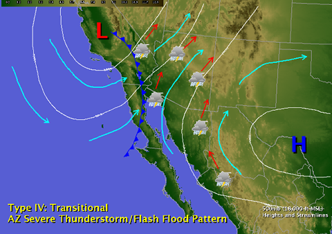 |
| Type IV: Transitional |
| References: |
|
Maddox, R.A., McCollum, D., and Howard, K., 1995: Large-scale patterns associated with severe summertime thunderstorms over Central Arizona. Wea. Forecasting, 763-778. McCollum, D.M., 1993: Synoptic-scale patterns associated with severe thunderstorms in Arizona during the summer monsoon. M.S. thesis, School of Meteorology, University of Oklahoma, 166 pp. |
| Upper Level Lows and the Monsoon. PDF version |
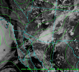
| Although the North American Monsoon has been researched extensively since 1990, there are several components that are still being explored. One of them involves fairly large, subtropical, upper level disturbances that interact with the monsoon. These upper level lows behave very differently than ones which travel west-to-east with the jet stream and affect Arizona during the winter. These subtropical upper lows move east-to-west, tend to be strongest in the upper levels of the atmosphere, and tend to generate more precipitation on their outer edges than near their centers. It is also unusual for these lows to generate a surface low pressure system or surface front. This makes them virtually impossible to track using surface information alone. Fortunately, they can be tracked using upper level observations and especially water vapor satellite imagery (Figure 1). |
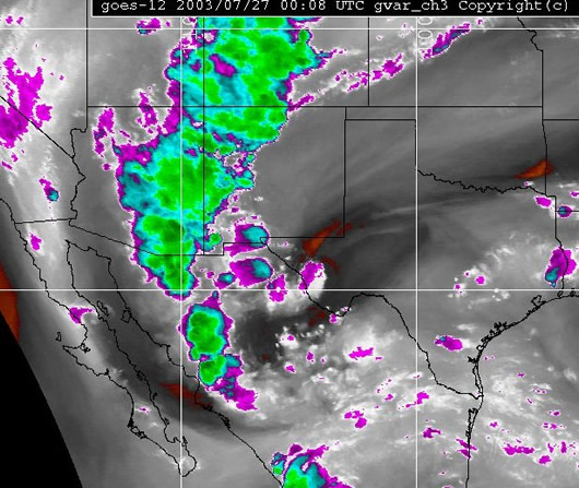 |
| Figure 1: Water vapor satellite image of a subtropical upper low, moving west from Texas toward Arizona, 508 pm MST, July 26, 2003. This low triggered a major severe thunderstorm outbreak across southeast Arizona. |
| These subtropical upper lows are known to produce heavy precipitation in other parts of the U.S. (Whitfield and Lyons 1992) and the world (Kelley and Mock 1982). These upper lows have also been known to enhance monsoon-related thunderstorms in Australia (Keenan and Brody 1988). However, during the North American Monsoon Experiment, it became apparent that these lows are a primary driver of thunderstorm outbreaks across northwest Mexico and the southwest U.S. (NAME Science Plan 2004). This was confirmed in several post-NAME studies (Pytlak, et al. 2005; Pytlak 2006; Englehart and Douglas 2006; Douglas and Englehart 2007). The studies also showed that unlike other parts of the world where the thunderstorms tended to develop on the west sides of the lows while the east sides remained quiet, large thunderstorm outbreaks can occur anywhere near these upper lows, especially when the approach the high terrain of the Sierra Madres or southern Rockies. |
| An idealized depiction of these upper lows is in Figure 2. As one of these lows moves west across the southern Plains of the U.S. or northern Mexico, the flow at jet stream level over the monsoon region is forced to diverge. This causes the air underneath to begin to rise and cool. The resulting large scale lift, combined with the mountains and monsoon moisture, causes thunderstorms to develop and grow into large Mesoscale Convective Systems (MCSs). Because the winds aloft also increase as a subtropical upper low approaches, wind shear usually increases, which allows thunderstorms to last longer than usual, move farther west into the deserts, and survive well into the night. If one of these upper lows passes directly overhead, sinking air at the center may briefly cause a downturn in thunderstorms. However as it moves off to the west, the counterclockwise flow around it will usually drag more moisture north and trigger yet more thunderstorms on the back side. |
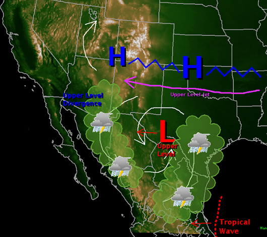 |
| Figure 2: Conceptual hypothesis of a subtropical upper tropospheric low moving west into the North American Monsoon regime. From Pytlak, et al, 2005. |
| Forecasting these upper level lows, and the thunderstorm outbreaks they can produce, remains a challenge. This hypothesis is still being researched, and it is unclear how strong or large these upper lows have to be to produce thunderstorm outbreaks. The amount of available moisture and the exact placement of the upper level high center are both critical, and not all of these upper lows ignite widespread thunderstorms. However, one study by Bieda, et al. (2008) supports the ideas that these upper lows enhance thunderstorm coverage and intensity, cause them to develop earlier in the day, and cause them to persist later into the night. Another study underway by Bosart, et al. (2007) suggests that many of these upper lows start their lives as upper level jet stream disturbances in the northern U.S., and can be better-tracked by monitoring the height of the tropopause (the temperature inversion which separates the lower- and middle atmosphere at about 50,000 feet). As the research into these features continues, we hope to improve our ability to forecast severe thunderstorm and flash flood outbreaks farther in advance. |
| References: |
|
Bieda, S.W., C.L. Castro, S.L Mullen, A.C. Comrie, and E. Pytlak, 2008: The relationship of transient upper-level troughs to intraseasonal and interannual variability of the North American Monsoon System. M.S. research paper, University of Arizona, Tucson, AZ. 35 pp. In review for J. Climate. Bosart, L.F., and coauthors, 2007: A Study of Southwestern US Warm Season Convection Associated with Westward- and Southwestward-Propagating Upper-Level Disturbances. Research Proposal for the Cooperative Project for Operational Meteorology Education and Training (COMET), Award Number: S07-66811. [Abstract available on line at: http://www.comet.ucar.edu/outreach/abstract_final/0766811.htm]. Douglas, A.V. and P.J. Englehart, 2007: A climatological perspective of transient synoptic features during NAME 2004. J. Climate, 20, 1947-1954. Englehart, P.J. and A.V. Douglas, 2006: Defining intraseaosnal rainfall variability within the North American Monsoon. J. Climate, 19, 4243-4253. Keenan, T.D. and L.R. Brody, 1988: Synoptic-scale moduilation of convection during the Australian summer monsoon. Mon Wea. Rev., 116, 71-85. Kelley, W.E. and D.R. Mock, 1982: A diagnostic study of upper tropospheric cold lows over the western North Pacific. Mon. Wea. Rev., 110, 471-480. North American Monsoon Experiment: Science Implementation Plan, 2004: NAME Science Working Group. [Available on line at http://www.cpc.ncep.noaa.gov/products/precip/monsoon/NAME.html.] Pytlak, E., M. Goering, and A. Bennett, 2005: Upper tropospheric lows and their interaction with the North American Monsoon. Preprint CD-ROM, Living with a Limited Water Supply, Symposium, 85th Annual Meeting of the American Meteorological Society, San Diego, CA. J.P. 2.3 Pytlak, E. 2006: Revisiting upper tropospheric lows and their interaction with the North American Monsoon: What is next in hypothesis formulation and testing? Oral presentation at the 31st Annual Meeting, National Weather Association, Cleveland, OH. [Available on line at http://www.nwas.org/meetings/nwa2006/index.php.] Whitfield, M.B. and S.W. Lyons, 1992: An upper-tropospheric low over Texas during summer. Wea. Forecasting, 7, 89-106. |
| For more information... PDF version |
| Monsoon references: |
| There are numerous references available on the North American Monsoon, ranging from broad overviews to detailed and highly technical material.
The National Weather Service in Tucson is greatly indebted to Dr. Chris Castro, Physics and Atmospheric Sciences Department, University of Arizona, for his academic review of this monsoon website. |
| General Interest: |
| ____, 2004: The North American Monsoon. Reports to the Nation on our Changing Planet. NOAA/National Weather Service. [Available on line at: http://www.cpc.noaa.gov/products/outreach/Report-to-the-Nation-Monsoon_aug04.pdf]
Glueck, J.R., 1997: Climate of Tucson, Arizona. NOAA Technical Memorandum, NWS-WR-249. Available upon request from NOAA/NWS Tucson, AZ. Shoemaker, C. and J.T. Davis, 2008: Hazardous Weather Climatology for Arizona. NOAA Technical Memorandum, NWS-WR 282. 47 pp. [Available on line at: https://www.wrh.noaa.gov/images/twc/monsoon/TM-282.pdf] |
| Academic Research Cited on This Page: |
| Adams, D.K., and A.C. Comrie, 1997: The North American Monsoon. Bull. Amer. Meteor. Soc., 78, 2197-2213.
Bieda, S.W., C.L. Castro, S.L Mullen, A.C. Comrie, and E. Pytlak, 2008: The relationship of transient upper-level troughs to intraseasonal and interannual variability of the North American Monsoon System. M.S. research paper, University of Arizona, Tucson, AZ. 35 pp. In review for J. Climate. Bosart, L.F., and coauthors, 2007: A Study of Southwestern US Warm Season Convection Associated with Westward- and Southwestward-Propagating Upper-Level Disturbances. Research Proposal for the Cooperative Project for Operational Meteorology Education and Training (COMET), Award Number: S07-66811. [Abstract available on line at: http://www.comet.ucar.edu/outreach/abstract_final/0766811.htm]. Carleton, A.M., D.A. Carpenter, and P. J. Weser, 1990: Mechanisms of Interannual Variability of the Southwest United States Summer Rainfall Maximum. J. Climate, 3, 999-1015. Castro, C.L., T.B. McKee, and R.A. Pielke, 2001: The Relationship of the North American Monsoon to Tropical and North Pacific Sea Surface Temperatures as Revealed by Observational Analyses. J. Climate, 14, 4449-4473. Castro, C.L., R.A. Pielke, and J.O. Adegoke, 2007: Investigation of the Summer Climate of the Contiguous United States and Mexico Using the Regional Atmospheric Modeling System (RAMS). Part I: Model Climatology (1950-2002). J. Climate, 20, 3844-3865. Castro, C.L., R.A. Pielke, and J.O. Adegoke ,2007: Investigation of the Summer Climate of the Contiguous United States and Mexico Using the Regional Atmospheric Modeling System (RAMS). Part II: Model Climate Variability. J. Climate, 20, 3866-3887. Douglas, A.V., and P.J. Englehart, 2007: A climatological perspective of transient synoptic features during NAME 2004. J. Climate, 20, 1947-1954. Douglas, M.W., 1995: The summertime low level jet over the Gulf of California. Mon. Wea. Rev., 123, 2334-2347. Douglas, M.W., and S. Li, 1996: Diurnal variation of the lower tropospheric flow over the Arizona low desert from SWAMP-1993 observations. Mon. Wea. Rev., 124, 1211-1224. Douglas, M.W., R.A. Maddox, K Howard, and S. Reyes, 1993: The Mexican monsoon. J. Climate, 6, 1665-1667. Englehart, P.J., and A.V. Douglas, 2006: Defining intraseaosnal rainfall variability within the North American Monsoon. J. Climate, 19, 4243-4253. Fuller, R.D., and D.J. Stensrud, 2000: The relationship between tropical easterly waves and surges over the Gulf of California during the North American Monsoon. Mon. Wea. Rev., 128, 2983-2989. Gutzler, D.S., 2000: Covariability of Spring Snowpack and Summer Rainfall across the Southwest United States. J. Climate, 13, 4018-4027. Gutzler, D.S., and J. Preston, 1997: Evidence for a relationship between spring snow cover in North America and summer rainfall in New Mexico. Geophysical Research Letters, 24, 2207-2210. Higgins, R.W., Y. Chen, Y. and A.V. Douglas, 1999: Interannual Variability of the North American Warm Season Precipitation Regime. J. Climate, 12, 653-679. Higgins, R.W., K.C. Mo, and Y. Yao, 1998: Interannual Variability of the U.S. Summer Regime with Emphasis on the Southwestern Monsoon. J. Climate, 11, 2583-2606. Higgins, R.W., and W. Shi, 2000: Dominant Factors Responsible for Interannual Variability of the Summer Monsoon in the Southwestern United States. J. Climate, 13, 759-776. Higgins, R.W., and W. Shi ,2001: Intercomparison of the Principal Modes of Interannual and Intraseasonal Variability of the North American Monsoon System. J. Climate, 14, 403-417. Holton, J.R., J.A. Curry, and J. A. Pyle (eds.), 2003: Monsoons. Encyclopedia of the Atmospheric Sciences. Elsevier Science Ltd., Oxford, UK, 3, 1365-1400. Johnson, R.H., P.E. Ciesielski, B.D. McNulty, P.J. Rogers, and R.K. Taft, 2007: Multiscale variability of the flow during the North American Monsoon Experiment. J. Climate, 20, 1628-1648. Kalnay, E., M. Kanamitsu, R. Kistler, W. Collins, D. Deaven, L. Gandin, M. Iredell, Keenan, T.D., and L.R. Brody, 1988: Synoptic-scale moduilation of convection during the Australian summer monsoon. Mon Weat Rev., 116, 71-85. Kelley, W.E., and D.R. Mock, 1982: A diagnostic study of upper tropospheric cold lows over the western North Pacific. Mon. Wea. Rev., 110, 471-480. Mo, K.C., and J.N. Paegle, 2000: Influence of Sea Surface Temperature Anomalies on the Precipitation Regimes over the Southwest United States. J. Climate, 13, 3588-3598. Maddox, R.A. McCollum, D., and Howard, K., 1995: Large-scale patterns associated with severe summertime thunderstorms over Central Arizona. Wea. Forecasting, 10, 763-778. McCollum, D.M., 1993: Synoptic-scale patterns associated with severe thunderstorms in Arizona during the summer monsoon. M.S. thesis, School of Meteorology, University of Oklahoma, 166 pp. McCollum, D., D. Bright, J. Meyer, and J. Glueck, 1996: Operational Applications of the Real-time National Lightning Detection Network Data at the NWSO Tucson, AZ. NOAA Technical Memorandum, NWS-WR-241 (PB97-108450) North American Monsoon Experiment: Science Implementation Plan, 20/04: NAME Science Working Group. [Available on line at http://www.cpc.ncep.noaa.gov/products/Global_Monsoons/American_Monsoons/NAME/index.shtml.] Pytlak, E., M. Goering, and A. Bennett, 2005: Upper tropospheric lows and their interaction with the North American Monsoon. Preprint CD-ROM, Living with a Limited Water Supply, Symposium, 85th Annual Meeting of the American Meteorological Society, San Diego, CA. J.P. 2.3 Pytlak, E. 2006: Revisiting upper tropospheric lows and their interaction with the North American Monsoon: What is next in hypothesis formulation and testing? Oral presentation at the 31st Annual Meeting, National Weather Association, Cleveland, OH. Rogers, P. J., and R.H. Johnson, 2007: Analysis of the 13-14 July gulf surge event during the 2004 North American Monsoon Experiment. Mon. Wea. Rev., 135, 3098-3117. Tang, M., and E.R. Reiter, 1984: Plateau monsoons of the Northern Hemisphere: a comparison between North America and Tobet. Mon Wea Rev., 112, 617-637. Vera, C., W. Higgins, J. Amador, T. Ambrizzi, R. Garreaud, D. Gochis, D. Gutzler, D. Lettenmaier, J. Marengo, C.R. Mechoso, J. Nogues-Paegle, P.L. Silva Dias, and C. Zhang, 2006: Toward a Unified View of the American Monsoon Systems. J. Climate, 19, 4977-5000. Whitfield, M.B., and S.W. Lyons, 1992: An upper-tropospheric low over Texas during summer. Wea. Forecasting, 7, 89-106. NCEP Reanalysis Derived data provided by the NOAA/OAR/ESRL PSD, Boulder, Colorado, USA, from their Web site at http://www.cdc.noaa.gov |
| Other Monsoon-Related References: |
Adang, T. C., and R. L. Gall, 1989: Structure and dynamics of the Arizona Monsoon Boundary. Mon. Wea. Rev., 117, 1423-1438. Andrade, E. R., W. D. Sellers, 1988: El Nino and its effect on precipitation in Arizona and western New Mexico. J. Climato., 8, 403-410. Badan-Dangon, A. C. E. Dorman, M. A. Merrifield, and C. D. Winant, 1991: The lower atmosphere over the Gulf of California. J. Geophys. Res., 96, 877-896. Balling, R. C., Jr., and S. W. Brazel, 1987: Diurnal variations in Arizona monsoon precipitation frequencies. Mon. Wea. Rev., 115, 342-346. Bartels, D. L., D. P. Jorgensen and B. F. Smull: Airborne Doppler analysis of a mesoscale convective system ovserved during the southwest area monsoon project. Preprints, 25th Intl. Conf. On Radar Meteorology, June 24-28, Paris. 486-489. Blake, D., 1923: Sonora storms. Mon Wea. Rev., 51, 585-588. Brazel, A. J., and W. G. Nickling, 1986: The relationship of weather types to dust storm generation in Arizona (1965-1980). J. Climato., 6, 255-275. Brenner, I. S., 1974: A surge of maritime tropical air-Gulf of California to the southwestern United States. Mon. Wea. Rev., 102, 375-389. Bright, D.R., and S.L. Mullen, 2002a: The sensitivity of the numerical simulation of the Southwest monsoon boundary layer and choice of PBL turbulence parameterization in MM5. Wea. Forecasting, 17, 99-114. Btight, D.R. and S.L. Mullen, 2002b: Short-range ensemble forecasts of precipitation during the southwest monsoon. Wea. Forecasting, 17, 1080-1100. Carleton, A. M., 1985: Synoptic and satellite aspects of the southwestern U.S. summer "monsoon." J. Climato., 5, 389-402. Carleton, A.M., 1986: Synoptic-dynamic character of 'bursts' and 'breaks' in the south-west U.S. summer precipitation singularity. J. Climato., 6, 605-622. Carleton, A.M., 1987: Summer circulation climate of the American southwest. Annals of the Association of American Geographers, 77, 619-634. Douglas, M.W., 1992: Structure and fluctuations of the summertime low-level jet over the Gulf of California and environs. Preprints, Fifth Conference on Mesoscale Processes, Jan. 5-10, Atlanta, GA. Fosdick, E.K., A.I. Watson, 1996: Cloud-to-ground lightning patterns in New Mexico during the summer. Natl. Weather Digest, 19, 17-24. Gao., X., J. Li, and S. Sorooshian, 2007: Modeling intraseasonal features of 2004 North American Monsoon Precipitation, J. Clumate, 20, 1882-1896. M. Gebremichael, E.R. Vivoni, C.J. Watts, and J.C. Rodriguez, 2007: Submesoscaile spatiotemporal variability of North American Monsoon raingall over complex terrain. J. Climate, 20, 1751-1773. Gochis, D.J., W.J. Shuttleworth, and Z. Yang, 2002a: Sensitivity of the modeled North American Monsoon regional climate to convective parameterization. Mon. Wea. Rev., 130, 1282-1298. Gochis, D.J., W.J. Shuttleworth, and Z. Yang, 2002b: Hydrometeorological response of the modeled North American Monsoon to convective parameterization. J. Hydrometeor. 4, 235-250. Gochis, D.J., C.J. Watts, J. Garatuza-Payan, and J. Cesar-Rodriguez, 2007: Spacial and temporal patterns of precipitation intensity as observed by the NAME event rain gage network from 2002 to 2004. J. Climate, 20, 1734-1750. Grantz, K., B. Rajagopalan, M. Clark, and E. Zagona, 2007: Seasonal shifts in the North American Monsoon. J. Climate, 20, 1923-1935. Green, C.R., and W.D. Sellers, Eds., 1964: Arizona Climate. University of Arizona Press, 503 pp. Green, G.D., D.Mitchell, and J.A. Haro, 1996: Mini supercell interaction: The February 13, 1995 Mesa tornado. NWS WR Tech. Attach., 96-32, 15pp. Green, G.D. and E. Pytlak, 2004: Severe weather outbreak over Phoenix, Arizona, on 14 July 2002. Preprints, 20th Conference on Weather Analysis and Forecasting, Amer. Meteor. Soc., Seattle, WA., P1.2. Hagemeyer, B.C., 1991: A lower-tropospheric thermodynamic climatology for March through September: some implications for thunderstorm forecasting. Wea. Forecasting, 6, 254-270. Higgins, R.W., Y. Yao, and X.L. Wang, 1997: Influence of the North American monsoon system on the U.S. summer precipitation regime. J. Climate, 10, 2600-2622. Holle, R.L., and S.P. Bennett, 1997: Lightning ground flashes associated with summer 1990 flash floods and stream flow in Tucson, Arizona: An exploratory study. Mon. Wea. Rev., 125, 1526-1536. Holle, R.L., and E.P. Krider, 2005: Suspension of an intercollegiate football game due to lightning. Preprints, International Conference on Lightning and Static Electricity, Seattle, WA, KMG-30. Janowiak, J.E., V.J. Dagostaro, V.E. Kousky, and R.J. Joyce, 2007: An examination of precipitation in observations and model forecasts during NAME with emphasis on the diurnal cycle. J. Climate, 20, 1680-1692. Lang, T.J., D.A. Ahijevych, S. W. Nesbitt, R.E. Carbone, S. Rutledge, and R. Cifelli, 2007: Radar-observed characteristics of precipitating systems during NAME 2004. J. Climate, 20, 1713-1733. Lopez, R.E., R.L. Holle, A.I. Watson, and J. Skindlov, 1997: Spatial and temporal distributions of lightning over Arizona from a power utility perspective. J. Appl. Meteor., 36, 825-831. Lorenz, D.J. and D.L. Hartmann, 2005: The effect of the MJO on the North American Monsoon. J. Climate, 19, 333-343. Maddox, R.A., C.F. Chappell, and L.R. Hoxit, 1979: Synoptic and meso-alpha scale aspects of flash flood events. Bull. Amer. Meteor. Soc., 60, 115-123. Maddox, R.A.,C.F. Canova, and L.R. Hoxit, 1980: Meteorological characteristics of flash flood events over the western United States. Mon. Wea. Rev., 108, 1866-1877. Maddox, R.A., M. Douglas, and K.W. Howard, 1991: Mesoscale precipitation systems over southwestern North America: A warm season overview. Preprints, Int. Conf. on Mesoscale Meteor. and TAMEX. Taipei, Taiwan. Amer. Meteor. Soc., 393-402. Maddox, R.A., K.W. Howard, and A.J. Negri, 1991: Analysis of GOES Infrared convective cloud-top temperatures for extended periods: An overview of the 1990 warm season for a subtropical region. Sixth Conf. on Satellite Meteorology and Oceanography, Atlanta, GA, Amer. Meteor. Soc., 205-208. Maddox, R.A., K.W. Howard, C.L. Dempsey, 1997: Intense convective storms with little or no lighting over central Arizona - A case of inadvertent weather modification? J. Appl. Meteor., 36, 302-314. Magril, C.S., R.H. Webb., M. Schaffner, S.W. Lyon, P.G. Griffiths, C. Shoemaker, C.L. Unkrich, S. Yatheendradas, P.A. Troch, E. Pytlak, D.C. Goodrich, S.L. Desilets, A. Youberg, and P.A. Peathtree, 2007: Impact of recent extreme Arizona storms. Eos Transactions, American Geophysical Union, 88, 191-193. McCollum, D.M., R.A. Maddox, and K.W. Howard, 1995: Case study of a severe Mesoscale convective system in central Arizona. Wea. Forcasting, 10, 643-665. Mestas-Nuñez, A.M., D. Ensfield, and C. Zhang, 2007: Water vapor fluxes over the intra-Americas Sea: seasonal and interannual variability and associations with rainfall. J. Climate, 20, 1910-1922. Mitchell, D.L., D. Ivanova, R. Rabin, T.J. Brown, and K. Redmond, 2002: Gulf of California sea surface temperatures and the North American Monsoon: mechanistic implications from observations. J. Climate, 15, 2261-2281. Mo, K.C., E. Rogers, W. Ebisuzaki, and R.W. Higgins, 2007: Influence of the North American Monsoon Experiment (NAME) 2004 enhanced soundings on NCEP operational analyses. J. Climate, 20, 1821-1842. Moore, T.J., R.L. Gall, and T.C. Adang, 1989: Disturbances along the Arizona monsoon boundary. Mon. Wea. Rev., 117, 932-941. Murphy, M.J., and R.L. Holle, 2005: Where is the real cloud-to-ground lightning maximum in North America? Wea. Forecasting, 20, 125-133. Negri, A.J., R.F. Adler, R.A. Maddox, K.W. Howard, and P.R. Keehn, 1993: A regional rainfall climatology over Mexico and the southwest United States derived from passive microwave and geosynchronous data. J. Climate, 6, 2144-2161. Pytlak, E., M. Murphy, N. Demetriades, R. Holle, 2008: Total lightning, radar and satellite observations of two monsoon thunderstorm events in the Tucson area in summer 2007. Preprints, 2nd International Lightning Meteorology Conference, Tucson, AZ. Ray, A.J., G.M. Garfin, M. Wilder, M. Vásquez-León, M. Lenart, and A.C. Comrie, 2007: Applications of monsoon research: opportunities to inform decision making and reduce regional vulnerability. J. Climate, 20, 1608-1626. Sellers, W.D., and R.H. Hill, 1974: Arizona Climate. 1931-1972. University of Arizona Press, 616 pp. Smith, W.P., and R.L. Gall, 1989: Tropical squall lines of the Arizona monsoon. Mon. Wea. Rev., 117, 1553-1569. Smith, W.P., 1986: The effects of eastern North Pacific tropical cyclones on the southwestern United States. NOAA Tech. Memo. NWS WR-197, 229 pp. [Available from NOAA National Weather Service, Western Region Headquarters, Scientific Services Division, P.O. Box 11188, Federal Bldg., Salt Lake City, UT 84147.] Stensrud, D.J., 1993: Elevated residual layers and their influence on surface boundary-layer evolution. J. Atmos. Sci., 50, 2284-2293. Stensrud, D.J., R.L. Gall, S.L. Mullen, and K.W. Howard, 1995: Model climatology of the Mexican Monsoon. J. Climate, 8, 1775-1794. Stensrud D.J., R.L. Gall, and M.K. Nordquist, 1997: Surges over the Gulf of California during the Mexican Monsoon. Mon. Wea. Rev., 125, 417-436. Vasquez, H., 1993: Weak upper level divergence and its role in organizing Mesoscale convective storms along the Arizona monsoon moisture boundary. NOAA/NWS Western Region Technical Attachment, 93-26. Wallace, C.E., R.A. Maddox, and K. Howard, 1999: Summertime Convective Storm Environments in Central Arizona: Local Observations. Wea. Forecasting, 14, 994-1006 Watson, A.I., R.E. Lopez, and R.L. Holle, 1994a: Cloud to ground lightning and upper-air patterns during bursts and breaks in the Southwest monsoon. Mon. Wea. Rev., 122, 1726-1739. Watson, A.I., R.E. Lopez, and R.L. Holle, 1994b: Diurnal cloud to ground lightning patterns in Arizona during the Southwest monsoon. Mon. Wea. Rev., 122, 1716-1725. Watts, C.J., R.L. Scott, J. Garatuza-Payan, J.C. Rodriguez, J.H. Prueger, W.P. Kustas and M. Douglas, 2007: Changes in vegetation condition and surface moisture fluxes during NAME 2004. J. Climate, 20, 1810-1820. Zhu, C., T. Cavazos, and D.P. Lettenmaier, 2007: Role of antecedent land surface conditions in warm season precipitation over northwestern Mexico. J. Climate, 20, 1774-1791. Zuidema, P. C. Fairall, L.H. Hartten, J.E. Hare, and D. Wolfe, 2007: On air-sea interaction at the mouth of the Gulf of California. J. Climate, 20, 1649-1661. |