
A slow moving storm system over the northern Gulf Coast will continue periods of showers and thunderstorms over much of the Southeast U.S. through this weekend. The risk for heavy to excessive rainfall increases on Sunday as a surge of increased moisture moves over parts of northern Florida into southern Georgia. Read More >
Last Map Update: Sat, May 10, 2025 at 1:20:07 am PDT

|
Text Product Selector (Selected product opens in current window)
|
|


 Social Media - Click to view more
 Elko Radar
 Regional Infrared Satellite Image
 National Weather Map - Click to enlarge
 Gridded Forecast Image
 Forecast Weather Tables
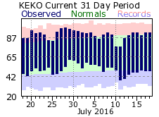 Recent LKN Temperatures
 Satellite-GOES
 Winter Weather