| 2017 Weather Highlights | Hydrology/Drought Status | Fire Weather | Records and Extremes | Monthly Highlights | Severe Weather |


|
Monthly Review of Weather Events Across New Mexico in 2017
|
|
|
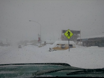
January 2017 was an active month with four storms bringing low elevation rain and higher elevation snow. A weak system on the first delivered mostly light amounts of snow to the northern mountains. The next storm on the 4th through 6th produced widespread rain and snow, including 1 to 2 feet of snow on the northern mountains. The third storm on the 14th through 15th blanketed mountain locations with around 1 foot of snow, and 2 feet reported near Magdalena. The fourth and final storm of the month was from the 22nd through 24th. It again delivered heavy snow to the northern mountains, on the order of 1 to 2 feet. Widespread rain and lighter snow fell elsewhere. January 2017 will likely end up as one of the wetter January's on record. Portions of central and eastern New Mexico ended up with 300 percent of normal or higher. The last week of the month finally produced an extended period of dry weather. Cold temperatures on the 25th through 27th gave way to milder, above normal highs and lows through the last few days of the month. A large swath from northwest to southeast New Mexico experienced above normal temperatures, while the northeast and southwest had near normal temperatures. |
January 21 heavy snow in Chama – photo courtesy of Deana Tafoya |
|
February 28 high winds caused overturned truck north of Roswell on SR 285 – photo courtesy of KOB-TV |
The first five days of February were quiet with chilly temperatures giving way to milder, above normal highs. Strong winds buffeted the state on the 6th and 8th. Record warmth graced portions of the state from the 9th through 11th. The first storm of the month blasted the state from the 12th through 14th with snow, rain and strong winds. The next storm on the 18th through the 19th was more tame with moderate snowfall in the western and northern mountains. High winds struck again on the 23rd and 28th with light rain at low elevations and moderate snow accumulations in the mountains.
|
|
March 2017 was drier and much warmer than normal. Below normal precipitation was common across all but the northeast and east central areas. Temperatures were above to well above normal statewide, and was easily the warmest March on record. Exceptionally strong winds pummeled New Mexico on the 6th. At least two dozen locations had wind gusts near or over 60 mph. Dry and exceptionally warm conditions produced record or near record highs from the 14th through 22nd. A pattern change to cooler and more unsettled weather finally arrived on the 23rd and continued through the end of the month. The storm on the 23rd to 24th delivered rain and mountain snow, along with widespread high winds. Blizzard conditions impacted the east slopes of the Sangre de Cristo Mountains and northeast with up to 21 inches of snow! The next system on the 28th to 29th produced widespread rain and higher mountain snow, as well as on the 31st as another storm approached. |
March 24 heavy snow near Eagle Nest - photo courtesy of Gavin Bevis
|
|
April 29 snow in Tijeras - photo courtesy of Cynthia Dares |
The month started with a bang as two storm systems brought mountain snow, lowland rain and strong winds through the first 5 days of the month. Strong winds buffeted the central and eastern areas of the state on the 9th. The first severe weather of the season struck on the 12th across Chaves County, including a confirmed weak tornado. Widespread beneficial rain fell over the eastern plains. It was pretty quiet from the 13th through 19th. Windy and cooler weather returned on the 20th into 22nd with only a little precipitation, although large hail was reported in the late evening of the 20th around Capulin. A warming trend started on the 22nd and continued through the 24th before a gradual cooling trend began on the 25th and continued for several days, along with increasing coverage of showers. An impressive spring storm on the 27th into early on the 29th produced widespread mountain snow, snow and blowing snow over the northeast, rain and isolated thunderstorms elsewhere. Strong winds produced extensive blowing snow in the northeast with white-out conditions. |
| The first week of May was quiet with dry weather and mostly above normal temperatures. That all changed on the 8th and 9th when severe weather struck eastern New Mexico on the afternoon and evening of the 8th, and much of northern and central New Mexico on the 9th. The amazing fact about the severe weather outbreak on the 9th was how widespread it was, and the duration of severe weather reports. The first report of severe weather, one inch hail, was reported near Fruitland in northwest New Mexico at 630am, while the last report of severe weather, again one inch hail, occurred near Portales at 1145pm MDT. In between, up to 2 inch diameter hail, a few tornadoes, and straight-line wind damage were documented. In all, this was one of the largest and longest duration outbreaks of severe weather ever recorded in New Mexico. Strong to high winds, and rain, including thunderstorms, were fairly widespread on the 16th. Large hail pelted the east central plains on the 22nd. Showers and thunderstorms returned late in the Memorial Day weekend through the end of the month. In between, from the 10th through 27th, mostly dry and warm weather was the norm. |
May 9 Tornado near Wagon Mound – photo courtesy of Tom Stef |
|
June 26 tennis ball size hail in Glorieta – photo courtesy of Wanda Gonzales |
The first three weeks of the month were mostly dry and hot. There were a couple of episodes of severe weather weather, most notably on the 6th and 7th. Isolated large hail and high winds were noted on the 20th through 23rd. A more active period of convection followed on the 24th through 26th and again on the 30th with numerous reports of severe weather, including large hail. |
|
Severe weather on June 30th spilled over into July 1st. Isolated reports of severe weather also occurred on the 2nd through 5th. Mostly dry and very warm conditions followed on the 6th through 8th. Spotty showers and thunderstorms began on the 9th and continued for the most part through the rest of the month, but the typical monsoon pattern of direct southerly flow bringing moisture into the state did not materialize. Torrential rains were pretty much non-existent until the end of the month, when flash floods were reported on the 27th, and 29th through 31st. |
July 17 funnel cloud in Albuquerque – photo courtesy of Allison Bridger |
|
August 25 mudslide near Red River - photo courtesy of KRQE-TV |
August 2017 delivered a typical supply of severe weather across the state, including flash flooding, large hail and damaging winds. Most of the severe weather, though, was across the eastern plains, which is more representative of April through June. Severe weather struck the east on the 9th (hail), 12th through 15th (hail and high winds) and 22nd (hail and flash flooding). The hail on the 9th was especially large, the size of golf balls in Las Vegas and east of Maes (San Miguel County). The weather was more tame across western and central New Mexico during this time. But some of these areas received plenty of rain, including around six inches near Los Alamos, Glenwood, Red Rock and Silver City. Cloudcroft picked up nearly eight inches of rain. The second half of August was relatively quiet by typical monsoon standards. The exception was on the 22nd when flash flooding occurred in Harding and Union Counties. |
|
September was relatively quiet through the 22nd, with the only reports of severe weather on the 14th, from thunderstorm wind gusts. A deep trough and closed low northwest of New Mexico on the 22nd pulled moisture north from Mexico, producing heavy rain and isolated flash flooding from the 23rd to the 25th. More heavy rain fell from the 27th through the end of the month. |
September 29 flash flood in Belen - photo courtesy of KRQE-TV |
|
|
The start of October continued the way late September ended - wet! More heavy rain and flooding occurred on the 4th into the 6th (see table below for sample rain amounts). Dry and seasonable weather ensued on the 7th and 8th. A cool down on the 9th and 10th allowed for the first snowfall of the season over the northern mountains. Amounts were light though, including around 3 inches in Angel Fire. Another warm-up followed for the 11th through 14th with mostly dry conditions. A sharp change to cooler on the 15th was quickly followed by another warming trend with dry conditions on the 16th to 18th. A welcome rain event unfolded on the 19th with widespread showers and thunderstorms. Dry and mostly mild weather embraced New Mexico from the 20th through 25th, with one brief cool down on the 24th. A powerful cold front blasted into the state on the 26th, sending cold air south and west. A little snow fell on the Sangre de Cristo Mountains and northeast highlands. The end of the month was quiet aside from a weak disturbance on Halloween. But only spotty light rain and mountain snow fell. |
|
The start of November was dry and much warmer than normal. In fact, near record highs were reported across the east from the 3rd through 5th. An upper level disturbance and surface cold front arrived on the 7th, delivering some rain and high mountain snow showers, as well as colder temperatures. A warming trend ensued with temperatures recovering to around normal on the 10th, then a dry and mild period of weather embraced the Land of Enchantment from the 11th through 17th, including some record highs. A strong cold front sent temperatures below normal on the 18th and 19th. Yet again, a big warm up followed for the 20th through the Thanksgiving weekend (26th). Generally above normal temperatures and dry weather continued through the remainder of the month. November 2017 set records for the warmest November on record for Albuquerque and Roswell. |
November 28 snow in Angel fire – photo courtesy of Ros Garland |
|
December 22, 2016 ice near Sandia Park – photo courtesy of Kerry Jones
|
The first 3 days of December continued unseasonably mild and dry. Colder air finally arrived on the 4th, with the 5th through 7th quite chilly; below to well below normal. This was quite a shock from the long duration of mild weather previously. And speaking of mild air, it returned starting on the 6th, and was in full force from the 7th through 13th, only backing off some on the 14th through 19th. It was dry during this time, aside from light snow in our southern mountains on the 16th to 17th. The remainder of the month was incredibly dry and unusually mild. Some arctic air did make it into the eastern plains on the 26th and 31st. |
| (Return to the main page) |


.jpg)

 Follow us on YouTube