Local and Regional Events:
September 12, 1931:
On this day in 1931, near-record or record heat came to an end across central and northeast South Dakota as well as west-central Minnesota. From September 9th through the 12th, many record highs were set at Aberdeen, Kennebec, Mobridge, Timber Lake, Watertown, and Wheaton. High temperatures during these four days ranged from 95 degrees to 109 degrees. Aberdeen rose to 107 degrees on the 10th, Kennebec rose to 109 on the 9th, Mobridge rose to 105 on the 9th, Timber Lake’s high was 106 on the 9th, Watertown rose to 104 on the 10th, and Wheaton rose to 108 degrees on the 10th.
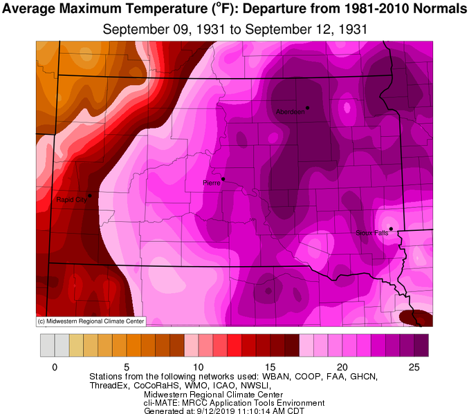
The image above shows the September 9-12, 1931 average high-temperature departure from normal.
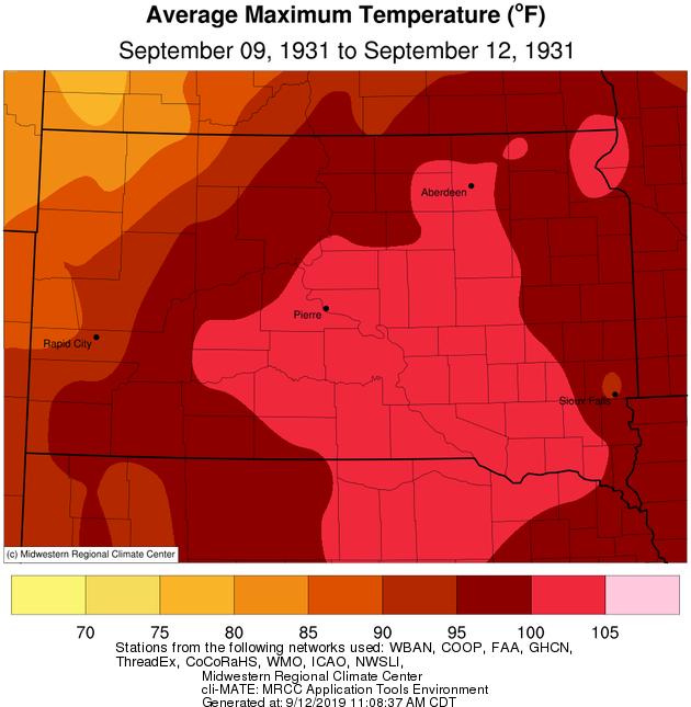
The image above shows the average high temperature from September 9-12, 1931.
U.S.A and Global Events for September 12th:
1857: The SS Central America sinks during a hurricane, killing 425 lives. Fourteen tons of gold was aboard the ship as well. Click HERE for a tweet from the Library of Congress.
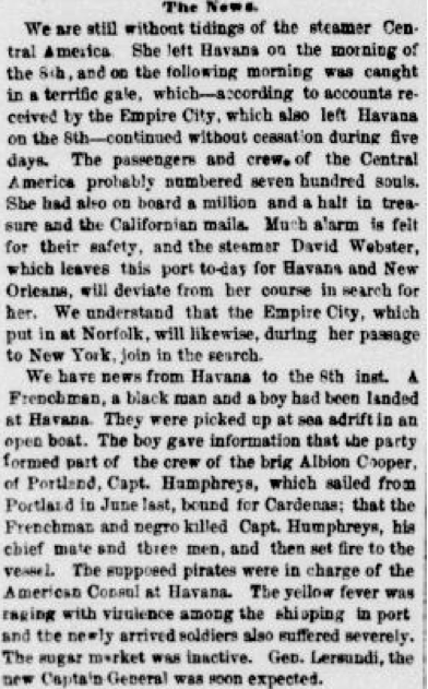
The newspaper clipping above is from the New York herald. September 17, 1857, MORNING EDITION, Page 4, Image 4 and is courtesy of Chronicling America.
1950: A hailstorm struck southern parts of Oklahoma City on this day. The storm damaged about 4,000 homes, 300 businesses, and 750 cars, resulting in a loss estimated at $987,000.
1961: Super Typhoon Nancy was an incredibly powerful tropical cyclone of the 1961 Pacific typhoon season. The system had possibly the strongest winds ever measured in a tropical cyclone and caused extensive damage and at least 173 deaths and thousands of injuries in Japan and elsewhere. A reconnaissance aircraft flying into the typhoon near its peak intensity on September 12 determined Nancy's one-minute sustained winds to be 215 mph. If these values are reliable, they would be the highest wind speeds ever measured in a tropical cyclone. However, it was later discovered that measurements and estimations of wind speeds from the 1940s to 1960s were excessive. Thus, Nancy's winds may be lower than its official best-track value.
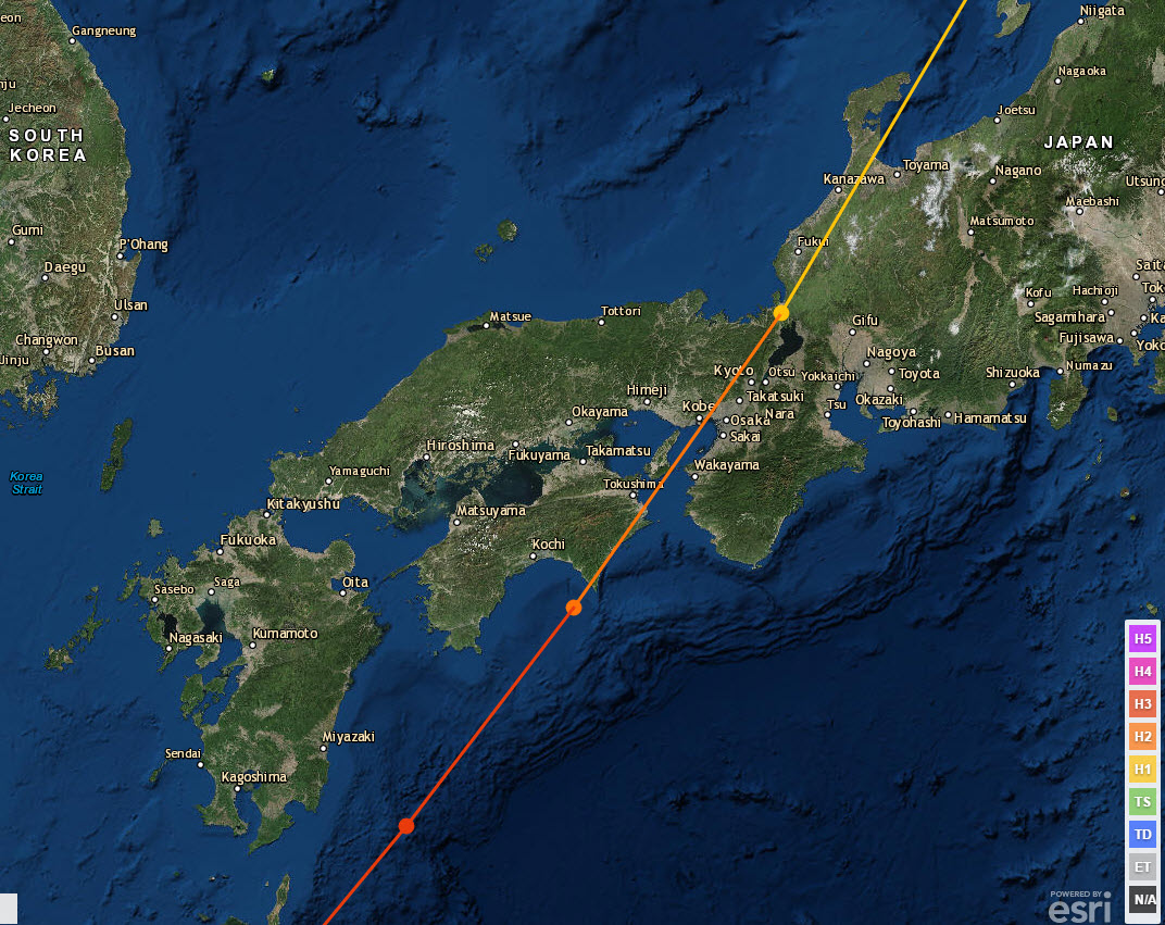
Typhoon Nancy made landfall on September 16 over Muroto Zaki.

Super Typhoon Nancy of 1961 on September 14th. The image is courtesy of the US Navy.
1963: President Kennedy gave his, “We choose to go to the moon” speech at Rice University.

Click HERE for a tweet from the NWS Office in Houston Texas.
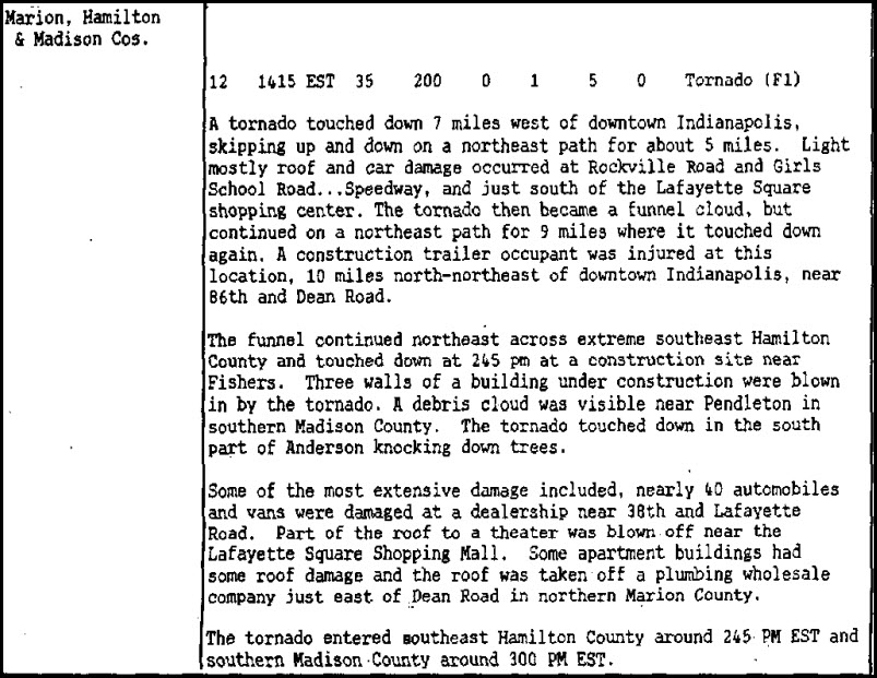
1988: An afternoon F1 tornado skipped across sections of Indianapolis, Indiana, damaging roofs and automobiles.
1999: Hurricane Floyd, a Category 4 storm with top winds of 145 mph, was making residents along the U.S. East Coast very nervous as it steamed steadily westward. Floyd was once forecast to strike Florida but turned away. Instead, Floyd hit the Bahamas at peak strength, causing substantial damage. It then paralleled the East Coast of the United States, causing massive evacuations and costly preparations from Florida through the Mid-Atlantic States.
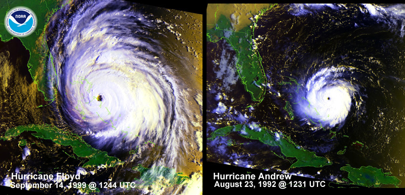
Above is a visual comparison of Hurricane Floyd and Hurricane Andrew. The two storms are at similar positions and nearly equal intensities (933 mbar), but Hurricane Floyd is remarkably more massive.
2006: Major flash flooding occurred in a matter of minutes after torrential rain starting pounding the city of Evansville, Indiana. A total of about 250 occupied structures sustained some degree of damage. Over 30 water rescues were conducted from cars stalled in floodwaters. Click HERE for more information from the NWS Office in Paducah, Kentucky.
Click HERE for more This Day in Weather History from the Southeast Regional Climate Center.

