 |
| Greening Begins in the Lower Valley Soaking Rains, Mild Temperatures Bring a Hint of Spring |
|
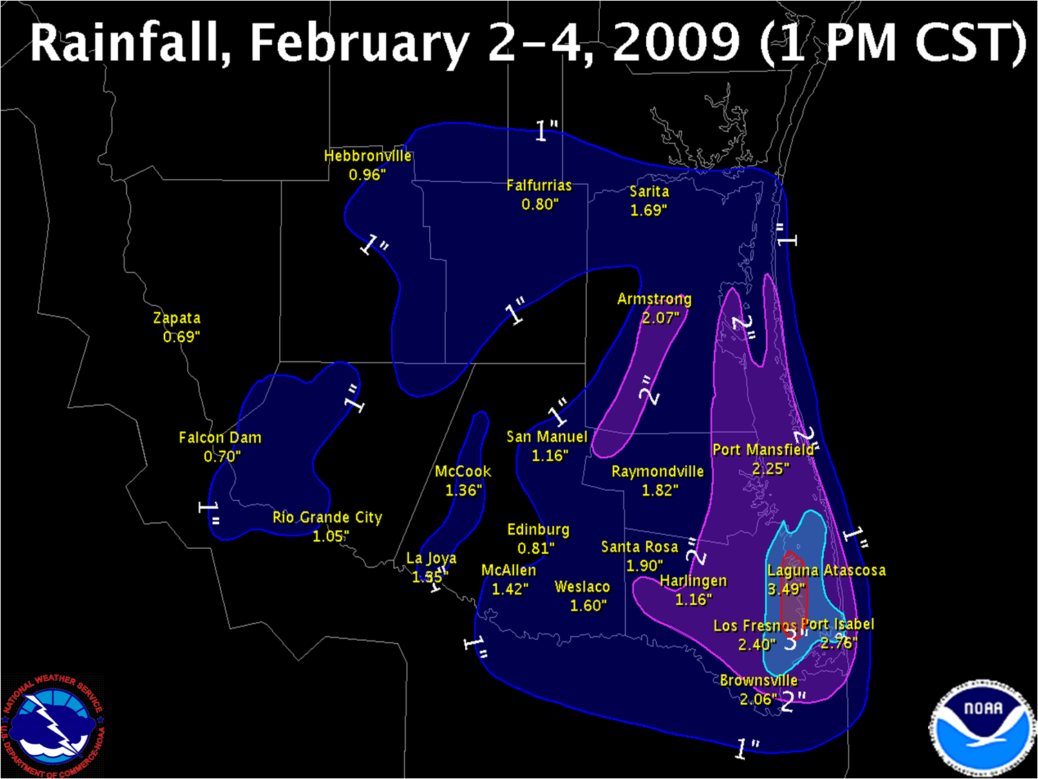
A large upper level disturbance crawling across the Southwestern U.S. and northern Mexico from Groundhog Day through Feburary 4th pulled deep tropical moisture across much of Texas for a prolonged period beginning on the evening of the 2nd and continuing through early afternoon of the 4th. The combination of deep moisture with an intense upper level jet streak close to the Lower RGV coast dropped 2 to 4 inches of rain from Cameron County through southern Kenedy County (above). Lesser, though still notable, rainfall of 1 to 2 inches fell in the Hidalgo County portion of the Lower RGV. In all these areas, the two day rainfall totals were above to well above the monthly average for February, which is a little more than an inch. The rain, combined with mild temperatures near 70 and humidity close to 100 percent triggered noticeable greening of some grasslands, a sure sign that Deep South Texas spring weather is not too far away. A summary of the rainfall data follows:
PUBLIC INFORMATION STATEMENT
NATIONAL WEATHER SERVICE BROWNSVILLE TX
348 PM CST THU FEB 4 2010

...PRELIMINARY RAINFALL TOTALS FOR DEEP SOUTH TEXAS...

THE FOLLOWING ARE PRELIMINARY RAINFALL TOTALS FOR DEEP SOUTH
TEXAS FROM FEBRUARY 2ND THROUGH MIDDAY TODAY. THESE VALUES
MAY BE UPDATED AS NEEDED AS SOME REPORTS MAY CONTAIN INCOMPLETE
DATA.


AIRPORTS/ASOS/RAWS          AMOUNT
====================================
LAGUNA ATASCOSA              3.49"
PORT ISABEL-CAMERON CO       2.76"
SANTA ANA NWR                2.65"
BROWNSVILLE                  2.06"
LINN-SAN MANUEL              1.71"
MCALLEN                      1.42"
HARLINGEN                    1.16"
FALCON LAKE                  1.03"
HEBBRONVILLE                 0.96"
EDINBURG                     0.81"
FALFURRIAS                   0.80"
ZAPATA                       0.69"


NWS COOPERATIVE OBSERVERS   AMOUNT*
====================================
PORT ISABEL                  3.08"
PORT MANSFIELD               2.25"
ARMSTRONG                    2.07"
HARLINGEN                    2.04"
ISLA BLANCA/S. PADRE         1.93"
SANTA ROSA                   1.90"
RAYMONDVILLE                 1.82"
MCALLEN                      1.80"
FALFURRIAS                   1.78"
EDINBURG                     1.71"
SARITA                       1.69"
HEBBRONVILLE                 1.68"
WESLACO                      1.60"
MERCEDES                     1.38"
MCCOOK                       1.36"
LA JOYA                      1.35"
SAN MANUEL                   1.16"
RIO GRANDE CITY              1.05"
FALCON DAM                   0.70"


VOLUNTEER COCORAHS          AMOUNT*
====================================
LOS FRESNOS 0.3 NE           2.40"
BROWNSVILLE 4.1 ENE          2.13"
BROWNSVILLE 4.9 NW           2.07"
BROWNSVILLE 4.4 NE           1.96"
SAN BENITO 5.0 SSE           1.95"
BROWNSVILLE 3.5 N            1.94"
RANCHO VIEJO 0.7 E           1.83"
BROWNSVILLE 0.9 SW           1.81"
HARLINGEN 2.6 ESE            1.80"
BROWNSVILLE 2.2 W            1.79"
BROWNSVILLE 4.1 NNE          1.59"
HARLINGEN 4.3 WSW            1.55"
HARLINGEN 4.7 WSW            1.48"


APRS/WXNET/CWOP/OTHER       AMOUNT
====================================
CW8690 LOS FRESNOS           1.54"
KC5WBG WESLACO               1.33"
CW3172 MISSION               1.17"
KB4OB MISSION                1.13"


*DENOTES RAINFALL TOTALS THROUGH 7AM THURSDAY.
|

